
Illinois Route 132
Encyclopedia
Illinois Route 132 is an arterial state road that connects Illinois Route 59
near Lake Villa
, with Illinois Route 131
in Waukegan
. It is known as Grand Avenue for its entire length, and Grand Avenue extends west beyond Lindenhurst to near U.S. Route 12
, 12 miles (19.3 km) west. Though Illinois 132 is one of the busiest state highways in Illinois, it is only 13.57 miles (21.8 km) long (21.83 km).
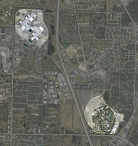 Illinois 132 serves the town of Gurnee
. Grand Avenue is the main road to both the Gurnee Mills
Shopping Center and Six Flags Great America
. At this point Illinois 132 is a divided, six lane road—its length wavers between 2 and 6 lanes around Gurnee.
Because Route 132 is a well-traveled road in suburban Chicago, it is also a major suburban Chicago shopping and industry corridor, especially on the Grand Avenue section of the route. A variety of car dealers, retail stores, full-service restaurants, mid-range hotels, etc. are located on this roadway.
from Decatur
to Mattoon
in central Illinois; in 1937, Illinois 121 replaced Illinois 131 and Illinois 132. In 1950 it was reassigned to the whole stretch of Grand Avenue; in 1967 it was dropped east of Illinois 131 and west of Illinois Route 59
.
.
Illinois Route 59
Illinois Route 59 is a north–south state highway in northeastern Illinois. It runs south from Illinois Route 83 in Antioch to Interstate Highway 55 in Shorewood, spanning the north–south width of Chicago's western suburbs...
near Lake Villa
Lake Villa, Illinois
Lake Villa is a village in Lake County, Illinois United States. The population was 5,864 at the 2000 census. Lake Villa lies within Lake Villa Township...
, with Illinois Route 131
Illinois Route 131
Illinois Route 131 is a north–south state road in northeastern Illinois. It extends south from Highway 31 and Lake CR A1/19 at the Illinois/Wisconsin state line by Pleasant Prairie, south to Illinois Route 176 in Lake Bluff, a distance of ....
in Waukegan
Waukegan, Illinois
Waukegan is a city and county seat of Lake County, Illinois. As of the 2000 census, the city had a total population of 87,901. The 2010 population was 89,078. It is the ninth-largest city in Illinois by population...
. It is known as Grand Avenue for its entire length, and Grand Avenue extends west beyond Lindenhurst to near U.S. Route 12
U.S. Route 12
U.S. Route 12 or US 12 is an east–west United States highway, running from Grays Harbor on the Pacific Ocean, in the state of Washington, to downtown Detroit, for almost . As a thoroughfare, it has mostly been supplanted by I-90 and I-94, but remains an important road for local travel.The...
, 12 miles (19.3 km) west. Though Illinois 132 is one of the busiest state highways in Illinois, it is only 13.57 miles (21.8 km) long (21.83 km).
Route description
Gurnee, Illinois
Gurnee is a village in Lake County, Illinois, United States. The population was 28,834 at the 2000 census, and estimated to be 30,772 in 2005. The village borders the city of Waukegan and is considered a part of the Chicago metropolitan area. Gurnee is perhaps best known for being the location of...
. Grand Avenue is the main road to both the Gurnee Mills
Gurnee Mills
Gurnee Mills is an indoor mall, established in Gurnee, Illinois. It's located about halfway between Chicago and Milwaukee, Wisconsin, a 40 minute drive either way, and near Six Flags Great America. It is a single-level Z-shaped mall. At of gross leasable area, it is the fourth largest mall in...
Shopping Center and Six Flags Great America
Six Flags Great America
Six Flags Great America is a Six Flags theme park in the Chicago metropolitan area, located in Gurnee, Illinois. It first opened in 1976 as Marriott's Great America. Six Flags purchased the park from the Marriott Corporation in 1984, making it the seventh park in the chain...
. At this point Illinois 132 is a divided, six lane road—its length wavers between 2 and 6 lanes around Gurnee.
Because Route 132 is a well-traveled road in suburban Chicago, it is also a major suburban Chicago shopping and industry corridor, especially on the Grand Avenue section of the route. A variety of car dealers, retail stores, full-service restaurants, mid-range hotels, etc. are located on this roadway.
History
SBI Route 132 was initially what is now Illinois Route 121Illinois Route 121
Illinois Route 121 is a major state road in central Illinois. Although it runs from northwest to southeast, it is marked as a north–south road. It runs from Illinois Route 130 in Greenup to Interstate 55 in Lincoln at the intersection of I-55 and Illinois Route 10...
from Decatur
Decatur, Illinois
Decatur is the largest city and the county seat of Macon County in the U.S. state of Illinois. The city, sometimes called "the Soybean Capital of the World", was founded in 1823 and is located along the Sangamon River and Lake Decatur in Central Illinois. In 2000 the city population was 81,500,...
to Mattoon
Mattoon, Illinois
Mattoon is a city in Coles County, Illinois, United States. The population was 18,555 as of the 2010 census. It is a principal city of the Charleston–Mattoon Micropolitan Statistical Area.Mattoon was the site of the "Mad Gasser" attacks of the 1940s....
in central Illinois; in 1937, Illinois 121 replaced Illinois 131 and Illinois 132. In 1950 it was reassigned to the whole stretch of Grand Avenue; in 1967 it was dropped east of Illinois 131 and west of Illinois Route 59
Illinois Route 59
Illinois Route 59 is a north–south state highway in northeastern Illinois. It runs south from Illinois Route 83 in Antioch to Interstate Highway 55 in Shorewood, spanning the north–south width of Chicago's western suburbs...
.
Major intersections
The entire route is in Lake CountyLake County, Illinois
Lake County is a county in the northeastern corner of the state of Illinois, on the shore of Lake Michigan. According to the 2010 census, it has a population of 703,462, which is an increase of 9.2% from 644,356 in 2000. Its county seat is Waukegan. The county is part of the Chicago metropolitan area...
.
| Location | Mile | Junction | Notes |
|---|---|---|---|
| Lake Villa Lake Villa, Illinois Lake Villa is a village in Lake County, Illinois United States. The population was 5,864 at the 2000 census. Lake Villa lies within Lake Villa Township... |
0.0 | ||
| 2.6 | |||
| Gurnee Gurnee, Illinois Gurnee is a village in Lake County, Illinois, United States. The population was 28,834 at the 2000 census, and estimated to be 30,772 in 2005. The village borders the city of Waukegan and is considered a part of the Chicago metropolitan area. Gurnee is perhaps best known for being the location of... |
7.0 | ||
| 9.9 | Cloverleaf interchange Cloverleaf interchange A cloverleaf interchange is a two-level interchange in which left turns, reverse direction in left-driving regions, are handled by ramp roads... |
||
| 11.2 | |||
| Waukegan Waukegan, Illinois Waukegan is a city and county seat of Lake County, Illinois. As of the 2000 census, the city had a total population of 87,901. The 2010 population was 89,078. It is the ninth-largest city in Illinois by population... |
12.7 | ||
| 13.57 |