
Illinois Route 8
Encyclopedia
Illinois Route 8 is an east–west state road in central Illinois
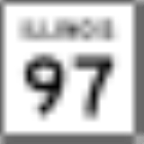
. It runs east from Illinois Route 97
south of Maquon
to the intersection of U.S. Route 24
(McClugage Avenue) and Business U.S. 24 near Washington
. Illinois 8 is 45.51 miles (73.24 km) long.
 Illinois 8 largely parallels Interstate 74
from Maquon to Washington. After entering Peoria
from the west, it crosses the Illinois River
with Illinois Route 29
and Illinois Route 116
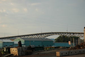
on the Cedar Street Bridge
between Peoria and East Peoria
. Illinois 8/29/116 stays joined until Main Street, where Illinois 29 continues southbound to Pekin
while Illinois 8/116 travel northbound, albeit briefly, towards I-74.
At Camp Street, Illinois 116 continues geographically northeast, and is signed east, with U.S. Route 150
westbound, forming a wrong-way concurrency. Illinois 8 turns east onto Camp Street with U.S. 150 eastbound. In spite of this concurrency
, as of 2005 the eastbound I-74 exit to Camp Street was only marked for U.S. 150, while the next eastbound exit to Washington Street was marked as "To Illinois 8" even though Washington Street is unnumbered in East Peoria. Past the Camp Street/Washington Street intersection, U.S. 150 leaves Illinois 8 and runs east-southeast towards Morton
, while Illinois 8 runs east-northeast through unincorporated Sunnyland.
Near Washington, Illinois 8 turns westbound onto Business U.S. 24 (despite being signed as East Illinois 8) to terminate at U.S. 24.
at the Iowa
state line to Sheldon
on U.S. Route 24
at the Indiana
state line. It was truncated in 1965, with some of its segments moving to its modern alignment from Illinois Routes 78
and 116
!County
!Location
!Mile
!Junction
!Notes
|-
|rowspan=2|Knox
|
|
|
|
|-
|
|bgcolor=#ddffdd|
|bgcolor=#ddffdd|
|bgcolor=#ddffdd|West end of IL 78 overlap
|-
|rowspan=3|Peoria
|Elmwood
|bgcolor=#ddffdd|
|bgcolor=#ddffdd|
|bgcolor=#ddffdd|East end of IL 78 overlap
|-
|rowspan=2|Peoria
|bgcolor=#ddffdd|
|bgcolor=#ddffdd|
|bgcolor=#ddffdd|West end of IL 116 overlap
|-
|bgcolor=#ddffdd|
|bgcolor=#ddffdd|
|bgcolor=#ddffdd|West end of IL 29 overlap
|-
|colspan=2 align=center|Illinois River
|colspan=3 align=center|Cedar Street Bridge
|-
|rowspan=7|Tazewell
|rowspan=5|East Peoria
|
|Edmund Street
|
|-
|bgcolor=#ddffdd|
|bgcolor=#ddffdd|
|bgcolor=#ddffdd|East end of IL 29 overlap
|-
|bgcolor=#ddffdd|
|bgcolor=#ddffdd|
|bgcolor=#ddffdd|East end of IL 116 overlap; West end of US 150 overlap
|-
|bgcolor=#ffdddd|
|bgcolor=#ffdddd|
|bgcolor=#ffdddd|Westbound exit and eastbound entrance
|-
|bgcolor=#ddffdd|
|bgcolor=#ddffdd|
|bgcolor=#ddffdd|East end of US 150 overlap
|-
|Washington
|bgcolor=#ddffdd|
|bgcolor=#ddffdd|
|bgcolor=#ddffdd|West end of US 24 Bus. overlap
|-
|
|bgcolor=#ddffdd|
|bgcolor=#ddffdd|
|bgcolor=#ddffdd|East end of US 24 Bus. overlap
Illinois
Illinois is the fifth-most populous state of the United States of America, and is often noted for being a microcosm of the entire country. With Chicago in the northeast, small industrial cities and great agricultural productivity in central and northern Illinois, and natural resources like coal,...
. It runs east from Illinois Route 97
Illinois Route 97
Illinois Route 97 is a north–south state highway in the central and western portions of the U.S. state of Illinois. It extends from exit 98 on Interstate 55 in Springfield northwest to U.S. Highway 150 near Galesburg. It crosses over the Illinois River on a bridge west of...
south of Maquon
Maquon, Illinois
Maquon is a village in Knox County, Illinois, United States. The population was 318 at the 2000 census. It is part of the Galesburg Micropolitan Statistical Area.-Description:...
to the intersection of U.S. Route 24
U.S. Route 24
U.S. Route 24 is one of the original United States highways of 1926. It originally ran from Pontiac, Michigan, in the east to Kansas City, Missouri, in the west. Today, the highway's eastern terminus is west of Clarkston, Michigan, at an intersection with I-75 and its western terminus is near...
(McClugage Avenue) and Business U.S. 24 near Washington
Washington, Illinois
Washington is a city in Tazewell County, Illinois, United States. The population was 10,841 at the 2000 census. There are currently 13,167 people living in Washington, according to a 2004 special census. Washington is part of the Peoria Metropolitan Statistical Area...
. Illinois 8 is 45.51 miles (73.24 km) long.
Route description
Interstate 74
Interstate 74 is an Interstate Highway in the Midwestern and Southeastern United States. Its western end is at an intersection with Interstate 80 in Davenport, Iowa; the eastern end of its Midwest segment is at an intersection with Interstate 75 in Cincinnati, Ohio...
from Maquon to Washington. After entering Peoria
Peoria, Illinois
Peoria is the largest city on the Illinois River and the county seat of Peoria County, Illinois, in the United States. It is named after the Peoria tribe. As of the 2010 census, the city was the seventh-most populated in Illinois, with a population of 115,007, and is the third-most populated...
from the west, it crosses the Illinois River
Illinois River
The Illinois River is a principal tributary of the Mississippi River, approximately long, in the State of Illinois. The river drains a large section of central Illinois, with a drainage basin of . This river was important among Native Americans and early French traders as the principal water route...
with Illinois Route 29
Illinois Route 29
Illinois Route 29 is a two to four lane state road that runs south from U.S. Route 6/Illinois Route 89 at Spring Valley to U.S. Route 51/Illinois Route 16 at Pana, running through Pekin, Peoria and Springfield. The nearest major north–south highway, Interstate 39, runs parallel to Illinois...
and Illinois Route 116
Illinois Route 116
Illinois Route 116 is a cross-state rural state highway that runs from U.S. Route 34 by Gladstone east to the intersection of U.S. Route 45 and Old U.S. Route 45, on the north side of Ashkum...
on the Cedar Street Bridge
Cedar Street Bridge
The Cedar Street Bridge carries Illinois Route 8, Illinois Route 29, and Illinois Route 116 over the Illinois River. It is about a mile and a half southwest from downtown. The bridge is a simple steel arch bridge that towers approximately 70 to above the surface of the river, and is the shortest...
between Peoria and East Peoria
East Peoria, Illinois
East Peoria is a city in Tazewell County, Illinois, United States. The population was 23,402 at the 2010 census. East Peoria is part of the Peoria, Illinois Metropolitan Statistical Area, located across the Illinois River from downtown Peoria. It is home to many Caterpillar Inc. facilities...
. Illinois 8/29/116 stays joined until Main Street, where Illinois 29 continues southbound to Pekin
Pekin, Illinois
Pekin is a the county seat of Tazewell County in the U.S. state of Illinois. Located on the Illinois River, Pekin is also the largest city of Tazewell County, and a key part of the Peoria metropolitan area. As of the 2010 census, its population is 34,094. A small portion of the city limits extends...
while Illinois 8/116 travel northbound, albeit briefly, towards I-74.
At Camp Street, Illinois 116 continues geographically northeast, and is signed east, with U.S. Route 150
U.S. Route 150
U.S. Route 150 is a 571 mile long northwest-southeast United States highway, signed as east–west. It runs from U.S. Route 6 outside of Moline, Illinois to U.S. Route 25 in Mount Vernon, Kentucky .-Illinois:In the state of Illinois, U.S. 150 runs from the Quad City International Airport at U.S...
westbound, forming a wrong-way concurrency. Illinois 8 turns east onto Camp Street with U.S. 150 eastbound. In spite of this concurrency
Concurrency (road)
A concurrency, overlap, or coincidence in a road network is an instance of one physical road bearing two or more different highway, motorway, or other route numbers...
, as of 2005 the eastbound I-74 exit to Camp Street was only marked for U.S. 150, while the next eastbound exit to Washington Street was marked as "To Illinois 8" even though Washington Street is unnumbered in East Peoria. Past the Camp Street/Washington Street intersection, U.S. 150 leaves Illinois 8 and runs east-southeast towards Morton
Morton, Illinois
Morton is a village in Tazewell County, Illinois, USA, known for its pumpkins and annual Pumpkin Festival. The population was 15,198 at the 2000 census. Morton, the home of a Caterpillar distribution facility and a Libby's pumpkin plant, is part of the Peoria, Illinois Metropolitan Statistical...
, while Illinois 8 runs east-northeast through unincorporated Sunnyland.
Near Washington, Illinois 8 turns westbound onto Business U.S. 24 (despite being signed as East Illinois 8) to terminate at U.S. 24.
History
SBI Route 8 ran from Gulfport on U.S. Route 34U.S. Route 34
U.S. Route 34 is an east–west United States highway that runs for 1,122 miles from north-central Colorado to the western suburbs of Chicago. Through Rocky Mountain National Park it is known as the Trail Ridge Road where it reaches 12,183 ft , making it the highest paved through highway in...
at the Iowa
Iowa
Iowa is a state located in the Midwestern United States, an area often referred to as the "American Heartland". It derives its name from the Ioway people, one of the many American Indian tribes that occupied the state at the time of European exploration. Iowa was a part of the French colony of New...
state line to Sheldon
Sheldon, Illinois
Sheldon is a village in Sheldon Township, Iroquois County, Illinois, United States. The population was 1,232 at the 2000 census, and 1,130 in 2009.-Geography:Sheldon is located at ....
on U.S. Route 24
U.S. Route 24
U.S. Route 24 is one of the original United States highways of 1926. It originally ran from Pontiac, Michigan, in the east to Kansas City, Missouri, in the west. Today, the highway's eastern terminus is west of Clarkston, Michigan, at an intersection with I-75 and its western terminus is near...
at the Indiana
Indiana
Indiana is a US state, admitted to the United States as the 19th on December 11, 1816. It is located in the Midwestern United States and Great Lakes Region. With 6,483,802 residents, the state is ranked 15th in population and 16th in population density. Indiana is ranked 38th in land area and is...
state line. It was truncated in 1965, with some of its segments moving to its modern alignment from Illinois Routes 78
Illinois Route 78
Illinois Route 78 is a major north–south highway in western Illinois. It runs from Illinois Route 104 northwest of Jacksonville north to Highway 78 at the Wisconsin state line north of Warren...
and 116
Illinois Route 116
Illinois Route 116 is a cross-state rural state highway that runs from U.S. Route 34 by Gladstone east to the intersection of U.S. Route 45 and Old U.S. Route 45, on the north side of Ashkum...
Major intersections
{| class=wikitable!County
!Location
!Mile
!Junction
!Notes
|-
|rowspan=2|Knox
Knox County, Illinois
Knox County is a county located in the U.S. state of Illinois. According to the 2010 census, it has a population of 52,919, which is a decrease of 5.2% from 55,836 in 2000...
|
|
|
|
|-
|
|bgcolor=#ddffdd|
|bgcolor=#ddffdd|
|bgcolor=#ddffdd|West end of IL 78 overlap
|-
|rowspan=3|Peoria
Peoria County, Illinois
Peoria County is a county located in the U.S. state of Illinois. According to the 2010 census, it has a population of 186,494, which is an increase of 1.7% from 183,433 in 2000. Its county seat is Peoria....
|Elmwood
Elmwood, Illinois
Elmwood is a city in Peoria County, Illinois, United States. The population was 1,945 at the 2000 census. Elmwood is part of the Peoria, Illinois Metropolitan Statistical Area...
|bgcolor=#ddffdd|
|bgcolor=#ddffdd|
|bgcolor=#ddffdd|East end of IL 78 overlap
|-
|rowspan=2|Peoria
Peoria, Illinois
Peoria is the largest city on the Illinois River and the county seat of Peoria County, Illinois, in the United States. It is named after the Peoria tribe. As of the 2010 census, the city was the seventh-most populated in Illinois, with a population of 115,007, and is the third-most populated...
|bgcolor=#ddffdd|
|bgcolor=#ddffdd|
|bgcolor=#ddffdd|West end of IL 116 overlap
|-
|bgcolor=#ddffdd|
|bgcolor=#ddffdd|
|bgcolor=#ddffdd|West end of IL 29 overlap
|-
|colspan=2 align=center|Illinois River
Illinois River
The Illinois River is a principal tributary of the Mississippi River, approximately long, in the State of Illinois. The river drains a large section of central Illinois, with a drainage basin of . This river was important among Native Americans and early French traders as the principal water route...
|colspan=3 align=center|Cedar Street Bridge
Cedar Street Bridge
The Cedar Street Bridge carries Illinois Route 8, Illinois Route 29, and Illinois Route 116 over the Illinois River. It is about a mile and a half southwest from downtown. The bridge is a simple steel arch bridge that towers approximately 70 to above the surface of the river, and is the shortest...
|-
|rowspan=7|Tazewell
Tazewell County, Illinois
Tazewell County is a county located in the U.S. state of Illinois. According to the 2010 census, it has a population of 135,394, which is an increase of 5.4% from 128,485 in 2000. Its county seat and largest city is Pekin. The majority of the population live in the suburbs and bedroom communities...
|rowspan=5|East Peoria
East Peoria, Illinois
East Peoria is a city in Tazewell County, Illinois, United States. The population was 23,402 at the 2010 census. East Peoria is part of the Peoria, Illinois Metropolitan Statistical Area, located across the Illinois River from downtown Peoria. It is home to many Caterpillar Inc. facilities...
|
|Edmund Street
|
|-
|bgcolor=#ddffdd|
|bgcolor=#ddffdd|
|bgcolor=#ddffdd|East end of IL 29 overlap
|-
|bgcolor=#ddffdd|
|bgcolor=#ddffdd|
|bgcolor=#ddffdd|East end of IL 116 overlap; West end of US 150 overlap
|-
|bgcolor=#ffdddd|
|bgcolor=#ffdddd|
|bgcolor=#ffdddd|Westbound exit and eastbound entrance
|-
|bgcolor=#ddffdd|
|bgcolor=#ddffdd|
|bgcolor=#ddffdd|East end of US 150 overlap
|-
|Washington
Washington, Illinois
Washington is a city in Tazewell County, Illinois, United States. The population was 10,841 at the 2000 census. There are currently 13,167 people living in Washington, according to a 2004 special census. Washington is part of the Peoria Metropolitan Statistical Area...
|bgcolor=#ddffdd|
|bgcolor=#ddffdd|
|bgcolor=#ddffdd|West end of US 24 Bus. overlap
|-
|
|bgcolor=#ddffdd|
|bgcolor=#ddffdd|
|bgcolor=#ddffdd|East end of US 24 Bus. overlap