

Illinois Route 29
Encyclopedia
Illinois Route 29 is a two to four lane state road that runs south from U.S. Route 6
/Illinois Route 89
at Spring Valley
to U.S. Route 51
/Illinois Route 16
at Pana
, running through Pekin
, Peoria
and Springfield
. The nearest major north–south highway, Interstate 39
, runs parallel to Illinois 29, but approximately fifty miles to the east. Illinois 29 is 175.36 miles (282.21 km) long.
 Illinois 29 runs near the right bank(going down stream) which is (north and west) of the Illinois River
from Spring Valley to Peoria. Starting at U.S. 6/Illinois 89 at the north edge of Spring Valley, the road passes through the small towns of Putnam
and Henry
, intersecting Illinois Route 18
at Henry. In Sparland
, Illinois 29 intersects Illinois Route 17
. It then runs beneath the bluff at Hopewell
before becoming 4th Street, the main north–south artery through Chillicothe
.
From the north end of Illinois Route 6
at Mossville
south through Peoria and Peoria Heights
, Route 29 is named Galena Road until it crosses U.S. Route 150
at the McClugage Bridge and merges with U.S. Route 24
from the bridge; from there the road is named Adams Street. South of downtown in Peoria, 29 splits from U.S. 24 onto the Cedar Street Bridge
, where it crosses the Illinois River
to East Peoria
with Illinois Route 8
and Illinois Route 116
.
At the east end of the Cedar Street Bridge, Routes 8 and 116 proceed north on East Peoria's Main Street, and Route 29 proceeds south, entering Creve Coeur
on Main Street and providing an interchange with Interstate 474
. It enters Pekin as 8th Street and forks off as 5th Street before a short concurrency with Illinois Route 9
near the Pekin Bridge. Splitting onto 2nd Street (southbound) and 3rd Street (northbound) before crossing the bridge, Route 29 exits Pekin as 2nd Street, passing the Federal Correctional Institution, Pekin
, and from there goes substantially directly south through Mason City
to Springfield
.
Route 29 enters Springfield at the Abraham Lincoln Capital Airport
, and runs around the north and east sides of the city. After leaving Springfield at an interchange with Interstate 72
/U.S. Route 36
, Route 29 runs southeast through Taylorville
, passing the end of Illinois Route 104
and crossing Illinois Route 48
, then ending at U.S. Route 51
/Illinois Route 16
in Pana
.
from Bureau Junction
to Spring Valley.
. While there are no longer funded plans to build the expressway, there are plans to attempt to reduce congestion on Illinois 29 by widening it from a narrow two lane highway to a four lane divided highway.
In September 2001, the Illinois Department of Transportation
(IDOT) began the Illinois 29 Study to determine feasible upgrade paths for this corridor.
The Illinois 29 Study covers Route 29 from Interstate 180
across the Illinois River from Hennepin
, south to Illinois Route 6
at Mossville
.
Along most of this stretch, the road is a striped, two lane (one northbound, one southbound) highway. In Chillicothe, the speed limit is reduced to 35 mph (56 km/h), though there are now four lanes (two northbound, two southbound). Truck traffic is relatively heavy along this stretch, owing to various industrial factories located in the towns.
, Sparland
, Hopewell
, and Chillicothe
. It is referred to as the "Bluff Alternate" because the highway would be relocated (south of Putnam) onto a bluff overlooking the Illinois River. Another alternate still under consideration is to merely upgrade the roads through Hopewell and Sparland to a divided four lane highway.
Some other considerations have already been withdrawn, including an eastern bypass of Putnam.
All solutions result in the lengthening of Illinois Route 6
to meet the new Illinois 29 just north of Peoria.
!County
!Location
!Mile
!Junction
!Notes
|-
|rowspan=3|Christian
|Pana
|
|
|
|-
|rowspan=2|Taylorville
|
|
|
|-
|
|
|
|-
|rowspan=6|Sangamon
|rowspan=4|Springfield
|
|
|
|-
|bgcolor=#ddffdd|
|bgcolor=#ddffdd|
|bgcolor=#ddffdd|South end of IL 97 overlap
|-
|
|
|
|-
|bgcolor=#ddffdd|
|bgcolor=#ddffdd|
|bgcolor=#ddffdd|North end of IL 97 overlap
|-
|
|
|
|
|-
|
|bgcolor=#ddffdd|
|bgcolor=#ddffdd|
|bgcolor=#ddffdd|South end of IL 123 overlap
|-
|Menard
|
|bgcolor=#ddffdd|
|bgcolor=#ddffdd|
|bgcolor=#ddffdd|North end of IL 123 overlap
|-
|rowspan=3|Mason
|Mason City
|
|
|
|-
|
|bgcolor=#ddffdd|
|bgcolor=#ddffdd|
|bgcolor=#ddffdd|South end of US 136 overlap
|-
|Allen
|bgcolor=#ddffdd|
|bgcolor=#ddffdd|
|bgcolor=#ddffdd|North end of US 136 overlap
|-
|rowspan=6|Tazewell
|rowspan=2|Pekin
|bgcolor=#ddffdd|
|bgcolor=#ddffdd|
|bgcolor=#ddffdd|South end of IL 9 overlap
|-
|bgcolor=#ddffdd|
|bgcolor=#ddffdd|
|bgcolor=#ddffdd|North end of IL 9 overlap
|-
|Pekin
, North Pekin
|
|
|
|-
|Creve Coeur
|
|
|
|-
|rowspan=2|East Peoria
|bgcolor=#ddffdd|
|bgcolor=#ddffdd|
|bgcolor=#ddffdd|South end of IL 8/IL 116 overlap
|-
|
|Edmund Street
|
|-
|colspan=2 align=center|Illinois River
|colspan=3 align=center|Cedar Street Bridge
|-
|rowspan=5|Peoria
|rowspan=4|Peoria
|bgcolor=#ddffdd|
|bgcolor=#ddffdd|
|bgcolor=#ddffdd|South end of US 24 overlap; North end of IL 8/IL 116 overlap
|-
|
|
|
|-
|
|
|
|-
|bgcolor=#ddffdd|
|bgcolor=#ddffdd|
|bgcolor=#ddffdd|North end of US 24 overlap
|-
|Mossville
|
|
|
|-
|rowspan=3|Stark
|rowspan=2|Sparland
|bgcolor=#ddffdd|
|bgcolor=#ddffdd|
|bgcolor=#ddffdd|South end of IL 17 overlap
|-
|bgcolor=#ddffdd|
|bgcolor=#ddffdd|
|bgcolor=#ddffdd|North end of IL 17 overlap
|-
|Henry
|
|
|
|-
|Putnam
|colspan=4 align=center|No major intersections
|-
|rowspan=4|Bureau
|
|
|
|
|-
|
|bgcolor=#ddffdd|
|bgcolor=#ddffdd|
|bgcolor=#ddffdd|South end of IL 26 overlap
|-
|Bureau
|bgcolor=#ddffdd|
|bgcolor=#ddffdd|
|bgcolor=#ddffdd|North end of IL 26 overlap
|-
|Spring Valley
|
|
|
|-
U.S. Route 6
U.S. Route 6 , also called the Grand Army of the Republic Highway, a name that honors an American Civil War veterans association, is a main route of the U.S. Highway system, running east-northeast from Bishop, California to Provincetown, Massachusetts. Until 1964, it continued south from Bishop to...
/Illinois Route 89
Illinois Route 89
Illinois Route 89 is a rural, north–south state highway in central Illinois. It runs from U.S. Route 34 in La Moille to Illinois Route 116 in Metamora. Routes 26 and 89 are the main north–south roads between Interstate 39/U.S. Route 51 and Illinois Route 29...
at Spring Valley
Spring Valley, Illinois
Spring Valley is a city situated on the Illinois River in Bureau County, Illinois. The population was 5,398 at the 2000 census. It is part of the Ottawa–Streator Micropolitan Statistical Area.-Geography:...
to U.S. Route 51
U.S. Route 51
U.S. Route 51 is a north–south United States highway that runs for 1,286 miles from the western suburbs of New Orleans, Louisiana to within of the Wisconsin-Michigan border. Much of the highway in Illinois and southern Wisconsin runs parallel to or overlaps Interstate 39...
/Illinois Route 16
Illinois Route 16
Illinois Route 16 is an arterial east–west highway in central Illinois. Its western terminus is at the Joe Page Bridge over the Illinois River in Hardin, while its eastern terminus is at Paris at Illinois Route 1 and U.S. Route 150, with Illinois Route 133. This is a distance of .- Route...
at Pana
Pana, Illinois
Pana is a city in Christian County, Illinois, United States. The population was 5,847 at the 2010 census.-Geography:Pana is located at .According to the United States Census Bureau, the city has a total area of , all of it land....
, running through Pekin
Pekin, Illinois
Pekin is a the county seat of Tazewell County in the U.S. state of Illinois. Located on the Illinois River, Pekin is also the largest city of Tazewell County, and a key part of the Peoria metropolitan area. As of the 2010 census, its population is 34,094. A small portion of the city limits extends...
, Peoria
Peoria, Illinois
Peoria is the largest city on the Illinois River and the county seat of Peoria County, Illinois, in the United States. It is named after the Peoria tribe. As of the 2010 census, the city was the seventh-most populated in Illinois, with a population of 115,007, and is the third-most populated...
and Springfield
Springfield, Illinois
Springfield is the third and current capital of the US state of Illinois and the county seat of Sangamon County with a population of 117,400 , making it the sixth most populated city in the state and the second most populated Illinois city outside of the Chicago Metropolitan Area...
. The nearest major north–south highway, Interstate 39
Interstate 39
Interstate 39 is a highway in the midwestern United States. I-39 runs from Normal, Illinois at Interstate 55 to Highway 29 in Rothschild, Wisconsin, approximately six miles south of Wausau. I-39 was designed to replace US Highway 51, which in the early 1980s was one of the busiest two-lane...
, runs parallel to Illinois 29, but approximately fifty miles to the east. Illinois 29 is 175.36 miles (282.21 km) long.
Route description
Illinois River
The Illinois River is a principal tributary of the Mississippi River, approximately long, in the State of Illinois. The river drains a large section of central Illinois, with a drainage basin of . This river was important among Native Americans and early French traders as the principal water route...
from Spring Valley to Peoria. Starting at U.S. 6/Illinois 89 at the north edge of Spring Valley, the road passes through the small towns of Putnam
Putnam, Illinois
Putnam is an unincorporated community in Putnam County, Illinois, United States. The community is located to the west of Senachwine Lake along Illinois Route 29 north of Henry. The largest population of the community is located at Lake Thunderbird north of the community....
and Henry
Henry, Illinois
Henry is a city in Marshall County, Illinois, United States. The population was 2,540 at the 2000 census. It is part of the Peoria, Illinois Metropolitan Statistical Area.-Geography:Henry is located at ....
, intersecting Illinois Route 18
Illinois Route 18
Illinois Route 18 is a rural east–west state road in central Illinois. It runs east from the town of Henry at Illinois Route 29 to the town of Blackstone at Illinois Route 17. This is a distance of .- Route description :...
at Henry. In Sparland
Sparland, Illinois
Sparland is a village in Marshall County, Illinois, United States. The population was 504 at the 2000 census. It is part of the Peoria, Illinois Metropolitan Statistical Area.-Geography:...
, Illinois 29 intersects Illinois Route 17
Illinois Route 17
Illinois Route 17 is a rural, arterial east–west state road that runs east from a former ferry crossing in New Boston along the banks of the Mississippi River to State Road 2 west of Lowell, Indiana. It is long.- Route description :...
. It then runs beneath the bluff at Hopewell
Hopewell, Illinois
Hopewell is a village in Marshall County, Illinois, United States. The population was 396 at the 2000 census. It is part of the Peoria, Illinois Metropolitan Statistical Area....
before becoming 4th Street, the main north–south artery through Chillicothe
Chillicothe, Illinois
Chillicothe is a city on the Illinois River in Peoria County, Illinois. The population was 5,996 at the 2000 census. Chillicothe is just north of the city of Peoria and is part of the Peoria, Illinois Metropolitan Statistical Area.- Geography :...
.
From the north end of Illinois Route 6
Illinois Route 6
Illinois Route 6 is a 4-lane freeway in central Illinois. It begins as a northern extension of Interstate 474 at Interstate 74 west of Peoria, and ends at Illinois Route 29 in Mossville, south of Chillicothe...
at Mossville
Mossville, Illinois
Mossville, Illinois is an unincorporated community between Peoria and Chillicothe in Peoria County, Illinois. Mossville is part of the Peoria, Illinois Metropolitan Statistical Area and resides closely to the northern part of Peoria...
south through Peoria and Peoria Heights
Peoria Heights, Illinois
Peoria Heights is a village lying almost entirely in Peoria County in the U.S. state of Illinois. The population was 6,635 at the 2000 census. Peoria Heights is a suburb of Peoria and is surrounded by the city except for its eastern boundary on Peoria Lake, a relatively wider section of the...
, Route 29 is named Galena Road until it crosses U.S. Route 150
U.S. Route 150
U.S. Route 150 is a 571 mile long northwest-southeast United States highway, signed as east–west. It runs from U.S. Route 6 outside of Moline, Illinois to U.S. Route 25 in Mount Vernon, Kentucky .-Illinois:In the state of Illinois, U.S. 150 runs from the Quad City International Airport at U.S...
at the McClugage Bridge and merges with U.S. Route 24
U.S. Route 24
U.S. Route 24 is one of the original United States highways of 1926. It originally ran from Pontiac, Michigan, in the east to Kansas City, Missouri, in the west. Today, the highway's eastern terminus is west of Clarkston, Michigan, at an intersection with I-75 and its western terminus is near...
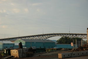
from the bridge; from there the road is named Adams Street. South of downtown in Peoria, 29 splits from U.S. 24 onto the Cedar Street Bridge
Cedar Street Bridge
The Cedar Street Bridge carries Illinois Route 8, Illinois Route 29, and Illinois Route 116 over the Illinois River. It is about a mile and a half southwest from downtown. The bridge is a simple steel arch bridge that towers approximately 70 to above the surface of the river, and is the shortest...
, where it crosses the Illinois River
Illinois River
The Illinois River is a principal tributary of the Mississippi River, approximately long, in the State of Illinois. The river drains a large section of central Illinois, with a drainage basin of . This river was important among Native Americans and early French traders as the principal water route...
to East Peoria
East Peoria, Illinois
East Peoria is a city in Tazewell County, Illinois, United States. The population was 23,402 at the 2010 census. East Peoria is part of the Peoria, Illinois Metropolitan Statistical Area, located across the Illinois River from downtown Peoria. It is home to many Caterpillar Inc. facilities...
with Illinois Route 8
Illinois Route 8
Illinois Route 8 is an east–west state road in central Illinois. It runs east from Illinois Route 97 south of Maquon to the intersection of U.S. Route 24 and Business U.S. 24 near Washington. Illinois 8 is long.- Route description :...
and Illinois Route 116
Illinois Route 116
Illinois Route 116 is a cross-state rural state highway that runs from U.S. Route 34 by Gladstone east to the intersection of U.S. Route 45 and Old U.S. Route 45, on the north side of Ashkum...
.
At the east end of the Cedar Street Bridge, Routes 8 and 116 proceed north on East Peoria's Main Street, and Route 29 proceeds south, entering Creve Coeur
Creve Coeur, Illinois
Creve Coeur is a village in Groveland Township, Tazewell County, Illinois, United States. As of the 2000 census, the village population was 5,448...
on Main Street and providing an interchange with Interstate 474
Interstate 474
Interstate 474 is an Interstate Highway loop route that provides a southern bypass around the north central Illinois city of Peoria. I-474's parent interstate is I-74. As the first digit of the interstate's number is even, it follows the established convention of providing a loop around a city....
. It enters Pekin as 8th Street and forks off as 5th Street before a short concurrency with Illinois Route 9
Illinois Route 9
Illinois Route 9 is a cross-state, east–west rural state highway in central Illinois. It runs from the Fort Madison Toll Bridge over the Mississippi River to Iowa in Niota east to State Road 26 at the Indiana border. This is a distance of ....
near the Pekin Bridge. Splitting onto 2nd Street (southbound) and 3rd Street (northbound) before crossing the bridge, Route 29 exits Pekin as 2nd Street, passing the Federal Correctional Institution, Pekin
Federal Correctional Institution, Pekin
Federal Correctional Institution, Pekin is medium security federal prison for males. It is located on Illinois Route 29 on the south edge of Pekin, Illinois, and there an adjacent satellite prison camp for minimum security female inmates....
, and from there goes substantially directly south through Mason City
Mason City, Illinois
Mason City is a city in Mason County, Illinois, United States. The population was 2,558 at the 2000 census, and 2,324 at a 2009 estimate.-Geography:Mason City is located at ....
to Springfield
Springfield, Illinois
Springfield is the third and current capital of the US state of Illinois and the county seat of Sangamon County with a population of 117,400 , making it the sixth most populated city in the state and the second most populated Illinois city outside of the Chicago Metropolitan Area...
.
Route 29 enters Springfield at the Abraham Lincoln Capital Airport
Abraham Lincoln Capital Airport
-Airport services:The airport has a Subway, a gift shop and an automated teller machine. TV and a lounge are also provided at the airport.-External links:* , official site* , official site* from USGS The National Map**...
, and runs around the north and east sides of the city. After leaving Springfield at an interchange with Interstate 72
Interstate 72
Interstate 72 is an Interstate Highway in the midwestern United States. Its western terminus is in Hannibal, Missouri, at an intersection with U.S. Route 61; its eastern terminus is at Country Fair Drive in Champaign, Illinois. In 2006, the Illinois General Assembly dedicated all of Interstate 72...
/U.S. Route 36
U.S. Route 36
U.S. Route 36 is an east–west United States highway that runs for from Rocky Mountain National Park, Colorado to Uhrichsville, Ohio. The highway's western terminus is at Deer Ridge Junction, an intersection in Rocky Mountain National Park, Colorado, where it meets U.S. Route 34. Its eastern...
, Route 29 runs southeast through Taylorville
Taylorville, Illinois
Taylorville is a city in Christian County, Illinois, United States. The population was 11,246 at the 2010 census. It is the county seat and largest city in Christian County.-Geography:Taylorville is located at ....
, passing the end of Illinois Route 104
Illinois Route 104
Illinois Route 104 is a state highway in central and western Illinois. It extends from Illinois Route 29 near Taylorville, west over the Illinois River at Meredosia to its western terminus in downtown Quincy. This is a distance of .- Route description :...
and crossing Illinois Route 48
Illinois Route 48
Illinois Route 48 is a north–south highway with its southern terminus at I-55 and Illinois Route 127 in Raymond and its northern terminus at Illinois Route 54 east of Clinton. This is a distance of .- Route description :...
, then ending at U.S. Route 51
U.S. Route 51
U.S. Route 51 is a north–south United States highway that runs for 1,286 miles from the western suburbs of New Orleans, Louisiana to within of the Wisconsin-Michigan border. Much of the highway in Illinois and southern Wisconsin runs parallel to or overlaps Interstate 39...
/Illinois Route 16
Illinois Route 16
Illinois Route 16 is an arterial east–west highway in central Illinois. Its western terminus is at the Joe Page Bridge over the Illinois River in Hardin, while its eastern terminus is at Paris at Illinois Route 1 and U.S. Route 150, with Illinois Route 133. This is a distance of .- Route...
in Pana
Pana, Illinois
Pana is a city in Christian County, Illinois, United States. The population was 5,847 at the 2010 census.-Geography:Pana is located at .According to the United States Census Bureau, the city has a total area of , all of it land....
.
History
Route 29 was established in 1918, and ran from DePue to Peoria. It was extended twice over Illinois Route 24 in 1936 and 1940, and in 1942 replaced an old alignment of U.S. Route 6U.S. Route 6
U.S. Route 6 , also called the Grand Army of the Republic Highway, a name that honors an American Civil War veterans association, is a main route of the U.S. Highway system, running east-northeast from Bishop, California to Provincetown, Massachusetts. Until 1964, it continued south from Bishop to...
from Bureau Junction
Bureau Junction, Illinois
Bureau Junction, usually called Bureau, is a village in Bureau County, Illinois, United States. The population was 368 at the 2000 census. Though its official name is Bureau Junction, the village is more commonly called Bureau, and Bureau is the main name used by phone companies, the federal Board...
to Spring Valley.
Future
Illinois 29 has long been slated as one of the roads to be upgraded as part of a Peoria-to-Chicago HighwayPeoria-to-Chicago Highway
The Peoria-to-Chicago Highway refers to an effort in the U.S. state of Illinois made in the late 1990s to directly connect the cities of Peoria and Chicago with a multilane freeway. Plans for any highway failed due to grass-roots efforts against the highway....
. While there are no longer funded plans to build the expressway, there are plans to attempt to reduce congestion on Illinois 29 by widening it from a narrow two lane highway to a four lane divided highway.
In September 2001, the Illinois Department of Transportation
Illinois Department of Transportation
The Illinois Department of Transportation is a state agency in charge of state-maintained public roadways of the U.S. state of Illinois. In addition, IDOT provides funding for rail, public transit and airport projects and administers fuel tax and federal funding to local juridictions in the...
(IDOT) began the Illinois 29 Study to determine feasible upgrade paths for this corridor.
The Illinois 29 Study covers Route 29 from Interstate 180
Interstate 180 (Illinois)
Interstate 180 is a north–south spur highway that runs from Princeton, Illinois to the small town of Hennepin, Illinois on its southern terminus. It is long.- Route description :...
across the Illinois River from Hennepin
Hennepin, Illinois
Hennepin is a village on the Illinois River in Putnam County, Illinois, United States. The population was 707 at the 2000 census. It is the county seat of Putnam County.Hennepin is part of the Ottawa–Streator Micropolitan Statistical Area.-Geography:...
, south to Illinois Route 6
Illinois Route 6
Illinois Route 6 is a 4-lane freeway in central Illinois. It begins as a northern extension of Interstate 474 at Interstate 74 west of Peoria, and ends at Illinois Route 29 in Mossville, south of Chillicothe...
at Mossville
Mossville, Illinois
Mossville, Illinois is an unincorporated community between Peoria and Chillicothe in Peoria County, Illinois. Mossville is part of the Peoria, Illinois Metropolitan Statistical Area and resides closely to the northern part of Peoria...
.
Along most of this stretch, the road is a striped, two lane (one northbound, one southbound) highway. In Chillicothe, the speed limit is reduced to 35 mph (56 km/h), though there are now four lanes (two northbound, two southbound). Truck traffic is relatively heavy along this stretch, owing to various industrial factories located in the towns.
Proposed solutions
IDOT is considering a western bypass of HenryHenry, Illinois
Henry is a city in Marshall County, Illinois, United States. The population was 2,540 at the 2000 census. It is part of the Peoria, Illinois Metropolitan Statistical Area.-Geography:Henry is located at ....
, Sparland
Sparland, Illinois
Sparland is a village in Marshall County, Illinois, United States. The population was 504 at the 2000 census. It is part of the Peoria, Illinois Metropolitan Statistical Area.-Geography:...
, Hopewell
Hopewell, Illinois
Hopewell is a village in Marshall County, Illinois, United States. The population was 396 at the 2000 census. It is part of the Peoria, Illinois Metropolitan Statistical Area....
, and Chillicothe
Chillicothe, Illinois
Chillicothe is a city on the Illinois River in Peoria County, Illinois. The population was 5,996 at the 2000 census. Chillicothe is just north of the city of Peoria and is part of the Peoria, Illinois Metropolitan Statistical Area.- Geography :...
. It is referred to as the "Bluff Alternate" because the highway would be relocated (south of Putnam) onto a bluff overlooking the Illinois River. Another alternate still under consideration is to merely upgrade the roads through Hopewell and Sparland to a divided four lane highway.
Some other considerations have already been withdrawn, including an eastern bypass of Putnam.
All solutions result in the lengthening of Illinois Route 6
Illinois Route 6
Illinois Route 6 is a 4-lane freeway in central Illinois. It begins as a northern extension of Interstate 474 at Interstate 74 west of Peoria, and ends at Illinois Route 29 in Mossville, south of Chillicothe...
to meet the new Illinois 29 just north of Peoria.
Major intersections
{| class=wikitable!County
!Location
!Mile
!Junction
!Notes
|-
|rowspan=3|Christian
Christian County, Illinois
Christian County is a county located in the U.S. state of Illinois. According to the 2010 census, it has a population of 34,800, which is a decrease of 1.6% from 35,372 in 2000...
|Pana
Pana, Illinois
Pana is a city in Christian County, Illinois, United States. The population was 5,847 at the 2010 census.-Geography:Pana is located at .According to the United States Census Bureau, the city has a total area of , all of it land....
|
|
|
|-
|rowspan=2|Taylorville
Taylorville, Illinois
Taylorville is a city in Christian County, Illinois, United States. The population was 11,246 at the 2010 census. It is the county seat and largest city in Christian County.-Geography:Taylorville is located at ....
|
|
|
|-
|
|
|
|-
|rowspan=6|Sangamon
Sangamon County, Illinois
Sangamon County is a county located in the U.S. state of Illinois. According to the 2010 census, it has a population of 197,465, which is an increase of 4.5% from 188,951 in 2000...
|rowspan=4|Springfield
Springfield, Illinois
Springfield is the third and current capital of the US state of Illinois and the county seat of Sangamon County with a population of 117,400 , making it the sixth most populated city in the state and the second most populated Illinois city outside of the Chicago Metropolitan Area...
|
|
|
|-
|bgcolor=#ddffdd|
|bgcolor=#ddffdd|
|bgcolor=#ddffdd|South end of IL 97 overlap
|-
|
|
|
|-
|bgcolor=#ddffdd|
|bgcolor=#ddffdd|
|bgcolor=#ddffdd|North end of IL 97 overlap
|-
|
|
|
|
|-
|
|bgcolor=#ddffdd|
|bgcolor=#ddffdd|
|bgcolor=#ddffdd|South end of IL 123 overlap
|-
|Menard
|
|bgcolor=#ddffdd|
|bgcolor=#ddffdd|
|bgcolor=#ddffdd|North end of IL 123 overlap
|-
|rowspan=3|Mason
|Mason City
Mason City, Illinois
Mason City is a city in Mason County, Illinois, United States. The population was 2,558 at the 2000 census, and 2,324 at a 2009 estimate.-Geography:Mason City is located at ....
|
|
|
|-
|
|bgcolor=#ddffdd|
|bgcolor=#ddffdd|
|bgcolor=#ddffdd|South end of US 136 overlap
|-
|Allen
|bgcolor=#ddffdd|
|bgcolor=#ddffdd|
|bgcolor=#ddffdd|North end of US 136 overlap
|-
|rowspan=6|Tazewell
Tazewell County, Illinois
Tazewell County is a county located in the U.S. state of Illinois. According to the 2010 census, it has a population of 135,394, which is an increase of 5.4% from 128,485 in 2000. Its county seat and largest city is Pekin. The majority of the population live in the suburbs and bedroom communities...
|rowspan=2|Pekin
Pekin, Illinois
Pekin is a the county seat of Tazewell County in the U.S. state of Illinois. Located on the Illinois River, Pekin is also the largest city of Tazewell County, and a key part of the Peoria metropolitan area. As of the 2010 census, its population is 34,094. A small portion of the city limits extends...
|bgcolor=#ddffdd|
|bgcolor=#ddffdd|
|bgcolor=#ddffdd|South end of IL 9 overlap
|-
|bgcolor=#ddffdd|
|bgcolor=#ddffdd|
|bgcolor=#ddffdd|North end of IL 9 overlap
|-
|Pekin
Pekin, Illinois
Pekin is a the county seat of Tazewell County in the U.S. state of Illinois. Located on the Illinois River, Pekin is also the largest city of Tazewell County, and a key part of the Peoria metropolitan area. As of the 2010 census, its population is 34,094. A small portion of the city limits extends...
, North Pekin
North Pekin, Illinois
North Pekin is a village in Tazewell County, Illinois, United States. The population was 1,574 at the 2000 census. North Pekin is a suburb of Peoria and is part of the Peoria, Illinois Metropolitan Statistical Area.-Geography:...
|
|
|
|-
|Creve Coeur
Creve Coeur, Illinois
Creve Coeur is a village in Groveland Township, Tazewell County, Illinois, United States. As of the 2000 census, the village population was 5,448...
|
|
|
|-
|rowspan=2|East Peoria
East Peoria, Illinois
East Peoria is a city in Tazewell County, Illinois, United States. The population was 23,402 at the 2010 census. East Peoria is part of the Peoria, Illinois Metropolitan Statistical Area, located across the Illinois River from downtown Peoria. It is home to many Caterpillar Inc. facilities...
|bgcolor=#ddffdd|
|bgcolor=#ddffdd|
|bgcolor=#ddffdd|South end of IL 8/IL 116 overlap
|-
|
|Edmund Street
|
|-
|colspan=2 align=center|Illinois River
Illinois River
The Illinois River is a principal tributary of the Mississippi River, approximately long, in the State of Illinois. The river drains a large section of central Illinois, with a drainage basin of . This river was important among Native Americans and early French traders as the principal water route...
|colspan=3 align=center|Cedar Street Bridge
Cedar Street Bridge
The Cedar Street Bridge carries Illinois Route 8, Illinois Route 29, and Illinois Route 116 over the Illinois River. It is about a mile and a half southwest from downtown. The bridge is a simple steel arch bridge that towers approximately 70 to above the surface of the river, and is the shortest...
|-
|rowspan=5|Peoria
Peoria County, Illinois
Peoria County is a county located in the U.S. state of Illinois. According to the 2010 census, it has a population of 186,494, which is an increase of 1.7% from 183,433 in 2000. Its county seat is Peoria....
|rowspan=4|Peoria
Peoria, Illinois
Peoria is the largest city on the Illinois River and the county seat of Peoria County, Illinois, in the United States. It is named after the Peoria tribe. As of the 2010 census, the city was the seventh-most populated in Illinois, with a population of 115,007, and is the third-most populated...
|bgcolor=#ddffdd|
|bgcolor=#ddffdd|
|bgcolor=#ddffdd|South end of US 24 overlap; North end of IL 8/IL 116 overlap
|-
|
|
|
|-
|
|
|
|-
|bgcolor=#ddffdd|
|bgcolor=#ddffdd|
|bgcolor=#ddffdd|North end of US 24 overlap
|-
|Mossville
Mossville, Illinois
Mossville, Illinois is an unincorporated community between Peoria and Chillicothe in Peoria County, Illinois. Mossville is part of the Peoria, Illinois Metropolitan Statistical Area and resides closely to the northern part of Peoria...
|
|
|
|-
|rowspan=3|Stark
Stark County, Illinois
Stark County is a county located in the U.S. state of Illinois. According to the 2010 census, it has a population of 5,994, which is a decrease of 5.3% from 6,332 in 2000...
|rowspan=2|Sparland
Sparland, Illinois
Sparland is a village in Marshall County, Illinois, United States. The population was 504 at the 2000 census. It is part of the Peoria, Illinois Metropolitan Statistical Area.-Geography:...
|bgcolor=#ddffdd|
|bgcolor=#ddffdd|
|bgcolor=#ddffdd|South end of IL 17 overlap
|-
|bgcolor=#ddffdd|
|bgcolor=#ddffdd|
|bgcolor=#ddffdd|North end of IL 17 overlap
|-
|Henry
Henry, Illinois
Henry is a city in Marshall County, Illinois, United States. The population was 2,540 at the 2000 census. It is part of the Peoria, Illinois Metropolitan Statistical Area.-Geography:Henry is located at ....
|
|
|
|-
|Putnam
|colspan=4 align=center|No major intersections
|-
|rowspan=4|Bureau
Bureau County, Illinois
Bureau County is a county located in the U.S. state of Illinois. According to the 2010 census, it has a population of 34,978, which is a decrease of 1.5% from 35,503 in 2000. Its county seat is Princeton. Bureau County is part of the Ottawa–Streator Micropolitan Statistical Area...
|
|
|
|
|-
|
|bgcolor=#ddffdd|
|bgcolor=#ddffdd|
|bgcolor=#ddffdd|South end of IL 26 overlap
|-
|Bureau
|bgcolor=#ddffdd|
|bgcolor=#ddffdd|
|bgcolor=#ddffdd|North end of IL 26 overlap
|-
|Spring Valley
Spring Valley, Illinois
Spring Valley is a city situated on the Illinois River in Bureau County, Illinois. The population was 5,398 at the 2000 census. It is part of the Ottawa–Streator Micropolitan Statistical Area.-Geography:...
|
|
|
|-