

U.S. Route 151
Encyclopedia
U.S. Route 151 is a U.S. Highway that runs through the states of Iowa
and Wisconsin
. The southern terminus for U.S. 151 is at a junction with Interstate 80
in Iowa County, Iowa
, and its northern terminus is at Manitowoc, Wisconsin
. The route, from south to north follows a northeasterly path through Iowa and Wisconsin.
Approximately seven miles (11 km) south of Dubuque, Iowa
, U.S. 151 joins with U.S. Highway 61. The two highways share a route from there to Dickeyville, Wisconsin
. Three miles (5 km) south of Dubuque, U.S. 61/151 join with U.S. Highway 52, and share a route with U.S. 52 until the White Street exit in Dubuque.
In Wisconsin, U.S. 61/151 joins with Highway 35
about one mile (1.6 km) north of the Iowa/Wisconsin border. At Dickeyville, U.S. 151 splits off and heads northeast to Platteville
. U.S. 61 and Highway 35 continue north. U.S. 151 later joins with U.S. Highway 18 near Dodgeville, Wisconsin
. The two highways share a route all the way to Madison, Wisconsin
.
, in an isolated part of Iowa near both Williamsburg
and Conroy
. It then continues through the area around the Amana Colonies
. Once meeting up with US 30 and US 218, the route cuts around the city of Cedar Rapids
, while the business route 151 goes through the city. The route splits from the other roads and continues toward Dubuque
as an expressway
. This 65 miles (104.6 km) stretch crosses many major rivers including both the Wapsipinicon
and the Maquoketa
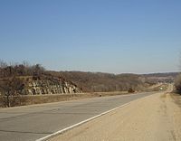
. The road eventually goes into the Driftless Area where it meets up with US 61 around the Dubuque Regional Airport
. The combined road then heads into the state of Wisconsin
where it continues with the US 151 name.
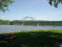
into Wisconsin via the Dubuque-Wisconsin Bridge
from Dubuque, Iowa and passes through a cut in the river ridge before turning northward to the western terminus of WIS 11 after 1 miles (1.6 km) of due east travel. WIS 35 and the Great River Road
join the route at that interchange, heading north. The highway at this point is limited access highway with two lanes in each direction. The northward trek of the route passes through mixed residential and farmland as it crosses Badger Road and merges with Eagle Point Road. Eagle Point road merges with US 151 from the left side of the road. The limited access portion ends at this interchange. Another pair of half diamond interchange
s connect the highway with CTH HHH and CTH H as it bypasses Kieler
to the northwest. At Dickeyville, US 61, WIS 35 and the Great River Road route turn north off of US 151 into town. US 151 passes Dickeville to the east and descends into a valley cut northeast of the village, paralleling the Little Platte River and Blockhouse creak within the valley for a 1 miles (1.6 km) stretch before climbing back onto the ridgetop on the other side of the valley. US 151 then approaches Platteville
and enters a section of limited access at CTH D (US 151 Business). The limited access stretch ends after three interchanges and 6 miles (9.7 km) to the east. The last of the interchanges being WIS 126/CTH G with access to Belmont
. The route turns northeastward from this point, crosses the Cottage Inn Branch and begins the first of several descents into valleys, two of which are prior to passing Mineral Point
and another two while passing the city.
The highway is limited access between the two interchanges that provide access to Mineral Point: CTH O and WIS 23. WIS 23 joins US 151 heading northbound at that point until the first interchange at Dodgeville. This interchange begins another short stretch of freeway to the point where US 18
joins the route. US 18 and US 151 head eastbound past that interchange.
The section of expressway past Dodgeville psses through rolling hills populated with farmland mixed with small woodlands. The highway passes Ridgeway
and Barneveld
. Access to Ridgeway is by surface intersections with a short "business route" on CTH HHH. However, it was announced in 2011 that the first intersection would be closed, and an exit would be constructed, due to the numerous fatal accidents that happen at the intersection each year. Access to Barneveld is at CTH ID on a lone interchange on the southwest side of the village. CTH ID Parallels US 18/US 151 for the entire stretch between Barneveld and Mount Horeb
. A section of freeway begins at WIS 78 and ends at the other end of CTH ID as the highway bypasses Mount Horeb just to the south of the city's passing residential subdivisions. A mix of grade separation and level intersections cross the winding highway as it continues eastward until the interchange with CTH MV (Verona Ave) begins a section of freeway that bypasses Verona
to the south. This section provides access to four interchanges including the two endpoints of CTH MV. The freeway ends and the route enters an urban multilane highway known as Verona Road as it passes through Fitchburg
and into Madison. Verona Road passes through a commercial sector at CTH PD and past a residential area on the Southwest Side of Madison. US 18 and US 151 merge east on the West Beltline Highway — joining US 12
and U.S. Route 14 in Wisconsin
.
as it passes to the south and east of downtown Madison. US 151 turns northwest onto South Blair Street for three city blocks to East Washington Avenue — where it turns northeast and follows East Washington Avenue out of the city. The left terminus of WIS 30 meets US 151 about 3 miles (4.8 km) northeast of the South Blair Street turn. and US 51 crosses US 151 1 miles (1.6 km) further northeast.
 At a cloverleaf interchange
with I-39, I-90
and I-94
, a section of freeway begins and continues along US 151 northeast through commercial zones into residential areas. The route bypasses Sun Prairie
on the west and north sides through the city's residential zones. After Sun Prairie, US 151 passes through farmland, heading toward Columbus. The highway bypasses the village via a partial beltline to the north and east, completely clearing the village. WIS 16 crosses under US 151 about midway along the Columbus bypass. US 151 becomes an expressway with level intersections after the interchange with WIS 73 at the end of the bypass portion. The route becomes a freeway at Beaver Dam, bypassing the city to the southeast. The route follows the edge of residential zones of the city before passing an industrial area at the northeast end of the bypass. Within this freeway section exists a level railroad crossing near CTH E (East Burnett Street). US 151 crosses at-grade intersections after the interchange with CTH A northeast of Beaver Dam and encounters one more freeway section at Waupun
, bypasses the city to the east. The four-lane expressway of US 151 continues east, bypassing Fond du Lac to the south and east. This expressway provides a mixture of at-grade intersections and grade-separated interchanges at US 41 and WIS 23. WisDOT currently is studying upgrades to two sections of US 151. The first study would preserve the Fond du Lac Bypass from US 41 to WIS 23, with the ultimate goal being freeway conversion. The second study is examining freeway upgrades to the route from WI 73 in Columbus to WIS 49 in Waupun.
 The multi-lane section of US 151 ends after turning north away from Fond du Lac and the route follows the east shore of Lake Winnebago for about half the length of the shoreline. US 151 then turns east at the intersection with WIS 55 and follows two-lane surface roads and briefly running concurrent with WIS 32 and WIS 57 in Chilton
. The roadway passes through farmland throughout this section until it crosses over I-43
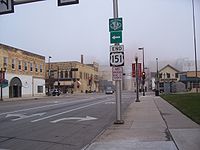
and enters Manitowoc. The route follows surface streets into Manitowoc and terminates in the downtown area at US 10
just blocks prior to the S.S. Badger
carferry port.
 U.S. 151 was one of the original highways from 1926. At the time, it only ran from Fond du Lac, Wisconsin
to Madison. Originally, the highway ended at Western Avenue and Main Street in Madison. In 1934, the highway was extended southwest to Cedar Rapids, Iowa
, incorporating the full length of former U.S. Route 118 (Dodgeville to Dickeyville) and part of former U.S. Route 161
(Dubuque to Cedar Rapids; US 161 from Cedar Rapids south to Keokuk became U.S. Route 218
). At the time, the southern end of the route was at Williams Blvd SW and 16th Ave SW, what was then U.S. Highways 30 and 218. In the 1940s, the highway was extended northeast to Manitowoc.
 In 1969, the Eagle Point Bridge
, which connected U.S. 151 and U.S. 61 with Wisconsin, was closed, and those highways were rerouted over the Julien Dubuque Bridge
with U.S. Route 20
from Dubuque to East Dubuque, Illinois
. The route then followed Illinois Route 35
and Wisconsin Highway 35 north to what is now the current highway. In 1982, the Dubuque-Wisconsin Bridge
opened, the old Eagle Point Bridge was demolished, and U.S. 151 and U.S. 61 was rerouted onto the new bridge. This is the only instance of U.S. 61 and U.S. 151 entering Illinois.
Iowa
Iowa is a state located in the Midwestern United States, an area often referred to as the "American Heartland". It derives its name from the Ioway people, one of the many American Indian tribes that occupied the state at the time of European exploration. Iowa was a part of the French colony of New...
and Wisconsin
Wisconsin
Wisconsin is a U.S. state located in the north-central United States and is part of the Midwest. It is bordered by Minnesota to the west, Iowa to the southwest, Illinois to the south, Lake Michigan to the east, Michigan to the northeast, and Lake Superior to the north. Wisconsin's capital is...
. The southern terminus for U.S. 151 is at a junction with Interstate 80
Interstate 80
Interstate 80 is the second-longest Interstate Highway in the United States, following Interstate 90. It is a transcontinental artery running from downtown San Francisco, California to Teaneck, New Jersey in the New York City Metropolitan Area...
in Iowa County, Iowa
Iowa County, Iowa
-2010 census:The 2010 census recorded a population of 16,355 in the county, with a population density of . There were 7,258 housing units, of which 6,677 were occupied.-2000 census:...
, and its northern terminus is at Manitowoc, Wisconsin
Manitowoc, Wisconsin
Manitowoc is a city in and the county seat of Manitowoc County, Wisconsin, United States. The city is located on Lake Michigan at the mouth of the Manitowoc River. According to the 2000 census, Manitowoc had a population of 34,053, with over 50,000 residents in the surrounding communities...
. The route, from south to north follows a northeasterly path through Iowa and Wisconsin.
Approximately seven miles (11 km) south of Dubuque, Iowa
Dubuque, Iowa
Dubuque is a city in and the county seat of Dubuque County, Iowa, United States, located along the Mississippi River. In 2010 its population was 57,637, making it the ninth-largest city in the state and the county's population was 93,653....
, U.S. 151 joins with U.S. Highway 61. The two highways share a route from there to Dickeyville, Wisconsin
Dickeyville, Wisconsin
Dickeyville is a village in Grant County, Wisconsin, United States. The population was 1,043 at the 2000 census.-Geography:Dickeyville is located at ....
. Three miles (5 km) south of Dubuque, U.S. 61/151 join with U.S. Highway 52, and share a route with U.S. 52 until the White Street exit in Dubuque.
In Wisconsin, U.S. 61/151 joins with Highway 35
Highway 35 (Wisconsin)
State Trunk Highway 35 is a Wisconsin state highway running north–south across western Wisconsin. It is in length, and is the longest state highway in Wisconsin...
about one mile (1.6 km) north of the Iowa/Wisconsin border. At Dickeyville, U.S. 151 splits off and heads northeast to Platteville
Platteville, Wisconsin
Platteville is the largest city in Grant County in southwestern Wisconsin. The population was 11,224 at the 2010 census, growing 12% since the 2000 Census. Much of this growth is likely due to the enrollment increase of the University of Wisconsin–Platteville...
. U.S. 61 and Highway 35 continue north. U.S. 151 later joins with U.S. Highway 18 near Dodgeville, Wisconsin
Dodgeville, Wisconsin
Dodgeville is the most populous city and county seat of Iowa County, Wisconsin, United States. The population was 4,698 at the 2010 census, making it the 9th largest city within the Madison metropolitan area. The Greater Dodgeville Area however had a population of 6,529...
. The two highways share a route all the way to Madison, Wisconsin
Madison, Wisconsin
Madison is the capital of the U.S. state of Wisconsin and the county seat of Dane County. It is also home to the University of Wisconsin–Madison....
.
Iowa
U.S. Route 151 starts at an intersection with Interstate 80Interstate 80
Interstate 80 is the second-longest Interstate Highway in the United States, following Interstate 90. It is a transcontinental artery running from downtown San Francisco, California to Teaneck, New Jersey in the New York City Metropolitan Area...
, in an isolated part of Iowa near both Williamsburg
Williamsburg, Iowa
Williamsburg is a city in Iowa County, Iowa, United States. The population was 2,622 at the 2000 census. Williamsburg is known for Holden's Foundation Seeds...
and Conroy
Conroy, Iowa
Conroy is an unincorporated community in central Iowa County, Iowa, United States. It lies along local roads southeast of the city of Marengo, the county seat of Iowa County. Its elevation is 879 feet . Although Conroy is unincorporated, it has a post office with the ZIP code of 52220,...
. It then continues through the area around the Amana Colonies
Amana Colonies
The Amana Colonies are a group of settlements of radical German Pietists in Iowa, USA, comprising seven villages. Calling themselves the Ebenezer Society or the Community of True Inspiration , they first settled in New York state near Buffalo in what is now the Town of West Seneca...
. Once meeting up with US 30 and US 218, the route cuts around the city of Cedar Rapids
Cedar Rapids, Iowa
Cedar Rapids is the second largest city in Iowa and is the county seat of Linn County. The city lies on both banks of the Cedar River, north of Iowa City and east of Des Moines, the state's capital and largest city...
, while the business route 151 goes through the city. The route splits from the other roads and continues toward Dubuque
Dubuque, Iowa
Dubuque is a city in and the county seat of Dubuque County, Iowa, United States, located along the Mississippi River. In 2010 its population was 57,637, making it the ninth-largest city in the state and the county's population was 93,653....
as an expressway
Limited-access road
A limited-access road known by various terms worldwide, including limited-access highway, dual-carriageway and expressway, is a highway or arterial road for high-speed traffic which has many or most characteristics of a controlled-access highway , including limited or no access to adjacent...
. This 65 miles (104.6 km) stretch crosses many major rivers including both the Wapsipinicon
Wapsipinicon River
The Wapsipinicon River is a tributary of the Mississippi River, approximately long, in northeastern Iowa in the United States. It drains a rural farming region of rolling hills and bluffs north of Waterloo and Cedar Rapids. The initial vowel rhymes with "pop".It rises in Mower County, Minnesota...
and the Maquoketa
Maquoketa River
The Maquoketa River is a tributary of the Mississippi River, approximately long, in northeastern Iowa in the United States. Its watershed covers within a rural region of rolling hills and farmland southwest of Dubuque. It is not to be confused with the Little Maquoketa River, another distinct...
. The road eventually goes into the Driftless Area where it meets up with US 61 around the Dubuque Regional Airport
Dubuque Regional Airport
Dubuque Regional Airport is a public airport located 6 miles south of Dubuque, Iowa along U.S. Highway 61. The airport's site is a parcel of land about 1,100 acre large. There are two runways for this airport....
. The combined road then heads into the state of Wisconsin
Wisconsin
Wisconsin is a U.S. state located in the north-central United States and is part of the Midwest. It is bordered by Minnesota to the west, Iowa to the southwest, Illinois to the south, Lake Michigan to the east, Michigan to the northeast, and Lake Superior to the north. Wisconsin's capital is...
where it continues with the US 151 name.
Dubuque to Madison
US 151, concurrent with US 61, crosses the Mississippi RiverMississippi River
The Mississippi River is the largest river system in North America. Flowing entirely in the United States, this river rises in western Minnesota and meanders slowly southwards for to the Mississippi River Delta at the Gulf of Mexico. With its many tributaries, the Mississippi's watershed drains...
into Wisconsin via the Dubuque-Wisconsin Bridge
Dubuque-Wisconsin Bridge
The Dubuque–Wisconsin Bridge is a steel tied arch bridge connecting Dubuque, Iowa, with still largely rural Grant County, Wisconsin. It is an automobile bridge that traverses the Mississippi River. It is one of two automobile bridges in the Dubuque area. A railroad bridge is between them...
from Dubuque, Iowa and passes through a cut in the river ridge before turning northward to the western terminus of WIS 11 after 1 miles (1.6 km) of due east travel. WIS 35 and the Great River Road
Great River Road
The Great River Road is a collection of state, provincial, federal, and local roads which follow the course of the Mississippi River through ten states of the United States...
join the route at that interchange, heading north. The highway at this point is limited access highway with two lanes in each direction. The northward trek of the route passes through mixed residential and farmland as it crosses Badger Road and merges with Eagle Point Road. Eagle Point road merges with US 151 from the left side of the road. The limited access portion ends at this interchange. Another pair of half diamond interchange
Diamond interchange
A diamond interchange is a common type of road junction, used where a freeway crosses a minor road. The freeway itself is grade-separated from the minor road, one crossing the other over a bridge...
s connect the highway with CTH HHH and CTH H as it bypasses Kieler
Kieler, Wisconsin
Kieler is an unincorporated census-designated place in the Town of Jamestown in Grant County, Wisconsin. It is located about seven miles northeast of the Iowa-Wisconsin border and the city of Dubuque, Iowa, and about four miles southwest of Dickeyville, Wisconsin, along U.S. Highway 61 and U.S....
to the northwest. At Dickeyville, US 61, WIS 35 and the Great River Road route turn north off of US 151 into town. US 151 passes Dickeville to the east and descends into a valley cut northeast of the village, paralleling the Little Platte River and Blockhouse creak within the valley for a 1 miles (1.6 km) stretch before climbing back onto the ridgetop on the other side of the valley. US 151 then approaches Platteville
Platteville, Wisconsin
Platteville is the largest city in Grant County in southwestern Wisconsin. The population was 11,224 at the 2010 census, growing 12% since the 2000 Census. Much of this growth is likely due to the enrollment increase of the University of Wisconsin–Platteville...
and enters a section of limited access at CTH D (US 151 Business). The limited access stretch ends after three interchanges and 6 miles (9.7 km) to the east. The last of the interchanges being WIS 126/CTH G with access to Belmont
Belmont, Wisconsin
Belmont is a village in Lafayette County, Wisconsin, United States. The population was 871 according to the 2000 census.-History:Founded in 1835 by land speculator John Atchison, Belmont was the original capital of the Wisconsin Territory, and the original territorial capitol building is preserved...
. The route turns northeastward from this point, crosses the Cottage Inn Branch and begins the first of several descents into valleys, two of which are prior to passing Mineral Point
Mineral Point, Wisconsin
Mineral Point is a city in Iowa County, Wisconsin, United States. The population was 2,617 at the 2000 census. In 2008 the city's population had taken a decline and is currently only 2,462, but still the second most populous community in Iowa County...
and another two while passing the city.
The highway is limited access between the two interchanges that provide access to Mineral Point: CTH O and WIS 23. WIS 23 joins US 151 heading northbound at that point until the first interchange at Dodgeville. This interchange begins another short stretch of freeway to the point where US 18
U.S. Route 18 in Wisconsin
In the U.S. state of Wisconsin, U.S. Route 18 runs east–west across the southern part of the state. The highway serves as major connecting route between Madison and the southwest corner of the state...
joins the route. US 18 and US 151 head eastbound past that interchange.
The section of expressway past Dodgeville psses through rolling hills populated with farmland mixed with small woodlands. The highway passes Ridgeway
Ridgeway, Wisconsin
Ridgeway is a village in Iowa County, Wisconsin, United States. It is the fourth most populous community in Iowa County. The population was 689 at the 2000 census. The village is located within the Town of Ridgeway...
and Barneveld
Barneveld, Wisconsin
Barneveld is a village in Iowa County, Wisconsin, United States. It is the fourth most populous community in Iowa County, while the second largest village, and largest village located fully within the county. The population was 1,088 at the 2000 census...
. Access to Ridgeway is by surface intersections with a short "business route" on CTH HHH. However, it was announced in 2011 that the first intersection would be closed, and an exit would be constructed, due to the numerous fatal accidents that happen at the intersection each year. Access to Barneveld is at CTH ID on a lone interchange on the southwest side of the village. CTH ID Parallels US 18/US 151 for the entire stretch between Barneveld and Mount Horeb
Mount Horeb, Wisconsin
Mount Horeb is a village in Dane County, Wisconsin, United States. The population was 7,009 at the 2010 census. It is part of the Madison Metropolitan Statistical Area.-Geography:...
. A section of freeway begins at WIS 78 and ends at the other end of CTH ID as the highway bypasses Mount Horeb just to the south of the city's passing residential subdivisions. A mix of grade separation and level intersections cross the winding highway as it continues eastward until the interchange with CTH MV (Verona Ave) begins a section of freeway that bypasses Verona
Verona, Wisconsin
Verona is a city in Dane County, Wisconsin, in the United States and is a suburb of Madison. As of the 2000 census, the city population was 7,052. With an estimated 2009 population of 11,486, Verona is among the fastest growing municipalities in the state. The city is located ten miles southwest of...
to the south. This section provides access to four interchanges including the two endpoints of CTH MV. The freeway ends and the route enters an urban multilane highway known as Verona Road as it passes through Fitchburg
Fitchburg, Wisconsin
Fitchburg is a city in Dane County, Wisconsin, United States. The population was 25,260 at the 2010 census. Fitchburg is a suburb of Madison and is part of the Madison Metropolitan Statistical Area.-History:...
and into Madison. Verona Road passes through a commercial sector at CTH PD and past a residential area on the Southwest Side of Madison. US 18 and US 151 merge east on the West Beltline Highway — joining US 12
U.S. Route 12 in Wisconsin
In the U.S. state of Wisconsin, U.S. Route 12 runs east–west across the western to southeast portions of the state...
and U.S. Route 14 in Wisconsin
U.S. Route 14 in Wisconsin
In the U.S. state of Wisconsin, U.S. Route 14 runs northwest-southeast across the western to southwest portions of the state. It links La Crosse and the southwestern portion of the state with Madison and Janesville...
.
Madison Metropolitan Area
The four U.S. Routes run concurrently for about 3 miles (4.8 km) to Park Street. At this interchange, US 14 turns south off the Beltine and US 151 turns north and into central Madison. US 151 passes Monona Bay to the west along South Park Street. US 151 turns northeast onto West Washington Ave for about 1500 feet, then follows Proudfit Street and North Shore Drive — paralleling the Monona Bay shore — and turns north onto John Nolen Drive. The street passes under the Monona Terrace Convention CenterMonona Terrace
Monona Terrace is a convention center on the shores of Lake Monona in Madison, Wisconsin.-Controversy:...
as it passes to the south and east of downtown Madison. US 151 turns northwest onto South Blair Street for three city blocks to East Washington Avenue — where it turns northeast and follows East Washington Avenue out of the city. The left terminus of WIS 30 meets US 151 about 3 miles (4.8 km) northeast of the South Blair Street turn. and US 51 crosses US 151 1 miles (1.6 km) further northeast.
Madison to Fond du Lac
Cloverleaf interchange
A cloverleaf interchange is a two-level interchange in which left turns, reverse direction in left-driving regions, are handled by ramp roads...
with I-39, I-90
Interstate 90 in Wisconsin
In the U.S. state of Wisconsin, Interstate 90 runs east–west through the western, central and southern portions of the state. A total of of Interstate 90 lie in Wisconsin.-Route description:...
and I-94
Interstate 94 in Wisconsin
In the U.S. state of Wisconsin, Interstate 94 runs east–west through the western, central and southeastern portions of the state.-Route description:A total of of Interstate 94 lie in Wisconsin....
, a section of freeway begins and continues along US 151 northeast through commercial zones into residential areas. The route bypasses Sun Prairie
Sun Prairie, Wisconsin
Sun Prairie is a city in Dane County in the U.S. state of Wisconsin. A suburb of Madison it is part of the Madison Metropolitan Statistical Area. The 2010 US Census estimates the city's population to be 29,364. It is the sixth-fastest growing city in Wisconsin, and the fastest-growing among cities...
on the west and north sides through the city's residential zones. After Sun Prairie, US 151 passes through farmland, heading toward Columbus. The highway bypasses the village via a partial beltline to the north and east, completely clearing the village. WIS 16 crosses under US 151 about midway along the Columbus bypass. US 151 becomes an expressway with level intersections after the interchange with WIS 73 at the end of the bypass portion. The route becomes a freeway at Beaver Dam, bypassing the city to the southeast. The route follows the edge of residential zones of the city before passing an industrial area at the northeast end of the bypass. Within this freeway section exists a level railroad crossing near CTH E (East Burnett Street). US 151 crosses at-grade intersections after the interchange with CTH A northeast of Beaver Dam and encounters one more freeway section at Waupun
Waupun, Wisconsin
Waupun is a city in Dodge and Fond du Lac Counties in the U.S. state of Wisconsin. The population was 10,718 at the 2000 census. In Fond du Lac County, there is also the Town of Waupun which abuts the city of Waupun....
, bypasses the city to the east. The four-lane expressway of US 151 continues east, bypassing Fond du Lac to the south and east. This expressway provides a mixture of at-grade intersections and grade-separated interchanges at US 41 and WIS 23. WisDOT currently is studying upgrades to two sections of US 151. The first study would preserve the Fond du Lac Bypass from US 41 to WIS 23, with the ultimate goal being freeway conversion. The second study is examining freeway upgrades to the route from WI 73 in Columbus to WIS 49 in Waupun.
Fond du Lac to Manitowoc
Chilton, Wisconsin
Chilton is a city in and county seat of Calumet County in the U.S. state of Wisconsin. The population was 3,708 at the 2000 census. The city is located partially within the Town of Chilton.-History:...
. The roadway passes through farmland throughout this section until it crosses over I-43
Interstate 43
Interstate 43 is a intrastate Interstate Highway located entirely within the U.S. state of Wisconsin, connecting Interstate 39 and Interstate 90 in Beloit with Milwaukee and U.S. Route 41 and U.S. Route 141 in Green Bay. I-43 is the 5th longest intrastate Interstate Highway of the Interstate...
and enters Manitowoc. The route follows surface streets into Manitowoc and terminates in the downtown area at US 10
U.S. Route 10 in Wisconsin
In the U.S. state of Wisconsin, U.S. Route 10 runs east–west across the central part of the state. It runs from the Prescott Drawbridge over the St...
just blocks prior to the S.S. Badger
S.S. Badger
The SS Badger is a coal-fired passenger and vehicle ferry in the United States that has been in Lake Michigan service from 1953 until the present. Currently, she shuttles between Ludington, Michigan and Manitowoc, Wisconsin. She is the last coal-fired passenger vessel operating on the Great...
carferry port.
History
Fond du Lac, Wisconsin
Fond du Lac is a city in Fond du Lac County, Wisconsin, United States. The name is French for bottom of the lake, for it is located at the bottom of Lake Winnebago. The population was 42,203 at the 2000 census...
to Madison. Originally, the highway ended at Western Avenue and Main Street in Madison. In 1934, the highway was extended southwest to Cedar Rapids, Iowa
Cedar Rapids, Iowa
Cedar Rapids is the second largest city in Iowa and is the county seat of Linn County. The city lies on both banks of the Cedar River, north of Iowa City and east of Des Moines, the state's capital and largest city...
, incorporating the full length of former U.S. Route 118 (Dodgeville to Dickeyville) and part of former U.S. Route 161
U.S. Route 161
U.S. Route 161 was a U.S. Highway in Iowa that ran from Keokuk to Dubuque by way of Cedar Rapids. The route of US 161 is now covered by two routes:*U.S. Route 218 from Keokuk to Cedar Rapids*U.S. Route 151 from Cedar Rapids to Dubuque...
(Dubuque to Cedar Rapids; US 161 from Cedar Rapids south to Keokuk became U.S. Route 218
U.S. Route 218
U.S. Route 218 is an original United States Highway, created in 1926. Although technically a spur of U.S. Route 18, US 218 neither begins nor ends at US 18, but overlaps US 18 for near Charles City, Iowa. US 218 begins at U.S. Route 136 in downtown Keokuk and ends away at...
). At the time, the southern end of the route was at Williams Blvd SW and 16th Ave SW, what was then U.S. Highways 30 and 218. In the 1940s, the highway was extended northeast to Manitowoc.
Illinois
Eagle Point Bridge
The Eagle Point Bridge was a very narrow two lane automobile bridge that connected urban Dubuque, Iowa and rural Grant County, Wisconsin. It was part of the US 61/US 151 route, and was a toll bridge. After the new Dubuque-Wisconsin Bridge was built in 1983, the Eagle Point Bridge was torn down...
, which connected U.S. 151 and U.S. 61 with Wisconsin, was closed, and those highways were rerouted over the Julien Dubuque Bridge
Julien Dubuque Bridge
The Julien Dubuque Bridge traverses the Mississippi River. It joins the cities of Dubuque, Iowa, and East Dubuque, Illinois. The bridge is part of the U.S. Highway 20 route...
with U.S. Route 20
U.S. Route 20
U.S. Route 20 is an east–west United States highway. As the "0" in its route number implies, US 20 is a coast-to-coast route. Spanning , it is the longest road in the United States, and the route sparsely parallels Interstate 90...
from Dubuque to East Dubuque, Illinois
East Dubuque, Illinois
East Dubuque is a city in Jo Daviess County, Illinois, United States. The population was 1,704 at the 2010 census, down from 1,995 at the 2000 census. East Dubuque is located alongside the Mississippi River. Across the river is the city of Dubuque, Iowa. About three miles north of the city is the...
. The route then followed Illinois Route 35
Illinois Route 35
Illinois Route 35 is a connector road between U.S. Route 20 in East Dubuque and Highway 35 at the Wisconsin state line. It is currently the shortest state highway in Illinois, a stark contrast to the highway north of the state line, which is Wisconsin's longest highway.- Route description :ILL 35...
and Wisconsin Highway 35 north to what is now the current highway. In 1982, the Dubuque-Wisconsin Bridge
Dubuque-Wisconsin Bridge
The Dubuque–Wisconsin Bridge is a steel tied arch bridge connecting Dubuque, Iowa, with still largely rural Grant County, Wisconsin. It is an automobile bridge that traverses the Mississippi River. It is one of two automobile bridges in the Dubuque area. A railroad bridge is between them...
opened, the old Eagle Point Bridge was demolished, and U.S. 151 and U.S. 61 was rerouted onto the new bridge. This is the only instance of U.S. 61 and U.S. 151 entering Illinois.