

Illinois Route 116
Encyclopedia
Illinois Route 116 is a cross-state rural state highway that runs from U.S. Route 34
by Gladstone
east to the intersection of U.S. Route 45
(North Front Street) and Old U.S. Route 45, on the north side of Ashkum
. This is a distance of 176.07 miles (283.36 km).
 The western terminus of Illinois 116 is approximately ten miles (16 km) from the Iowa
state line, east of Burlington, Iowa
. It crosses the Illinois River
from Peoria
to East Peoria
with Illinois Route 8
and Illinois Route 29
on the Cedar Street Bridge
.
On the southeast side of the Illinois River, it and U.S. Route 150
form a wrong-way concurrency. Travelling geographic northeast along the river, U.S. 150 is marked west before crossing the river to enter Peoria, and Illinois 116 is marked east. Travelling geographic southwest, U.S. 150 is marked east before branching to Morton
, and Illinois 116 is marked west before crossing the river to enter Peoria on its southern side.
, running from Peoria
through Biggsville
. It was approximately 80 miles (128.7 km) in length, and followed much of the route of IL 116 prior to its decommissioning. SBI Route 116 originally ran separately from east of Ashkum to East Peoria.
US 124 was one of the original 1928 US routes in IL (since US routes didn't appear on IL maps until then). It originally went from Peoria to Galesburg, along with the then IL-8
, via Farmington and Maquon on the route of the current IL 116 west from Peoria to IL-97
, north to IL-8, west to IL-97, then northwest on IL-97 to Galesburg, with the last few miles on the current US 150
.
In 1934, US 124 was rerouted west on the current IL 116 to near Biggsville, where it connected to US 34
(for access to Mississippi River crossing into Iowa). West bound traffic from Peoria had a choice. Proceed along US 24
to cross the Mississippi River at Quincy (south-west route) - the old Peoria to Quincy stage coach route, or take US 124 to cross the Mississippi River (US 34) at Burlington, IA (north-west route).
With the completion of Interstate 474
as a western bypass of Peoria in 1978, an Interstate connector (Exit 3 on Interstate 474) was constructed as the eastern terminus for the proposed western Illinois expressway (Peoria to Kansas City via Macomb and Quincy). The connector provides access to IL 116.
.
U.S. Route 34
U.S. Route 34 is an east–west United States highway that runs for 1,122 miles from north-central Colorado to the western suburbs of Chicago. Through Rocky Mountain National Park it is known as the Trail Ridge Road where it reaches 12,183 ft , making it the highest paved through highway in...
by Gladstone
Gladstone, Illinois
Gladstone is a village in Henderson County, Illinois, United States. The population was 284 at the 2000 census. It is part of the Burlington, IA–IL Micropolitan Statistical Area.-Geography:Gladstone is located at ....
east to the intersection of U.S. Route 45
U.S. Route 45
U.S. Route 45 is a north–south United States highway. US 45 is a border-to-border route, from Lake Superior to the Gulf of Mexico. A sign at the highway's northern terminus notes the total distance as ....
(North Front Street) and Old U.S. Route 45, on the north side of Ashkum
Ashkum, Illinois
Ashkum is a village in Ashkum Township, Iroquois County, Illinois, United States. The population was 724 at the 2000 census.-Geography:Ashkum is located at ....
. This is a distance of 176.07 miles (283.36 km).
Route description
Iowa
Iowa is a state located in the Midwestern United States, an area often referred to as the "American Heartland". It derives its name from the Ioway people, one of the many American Indian tribes that occupied the state at the time of European exploration. Iowa was a part of the French colony of New...
state line, east of Burlington, Iowa
Burlington, Iowa
Burlington is a city in, and the county seat of Des Moines County, Iowa, United States. The population was 25,663 in the 2010 census, a decline from the 26,839 population in the 2000 census. Burlington is the center of a micropolitan area including West Burlington, Iowa and Middletown, Iowa and...
. It crosses the Illinois River
Illinois River
The Illinois River is a principal tributary of the Mississippi River, approximately long, in the State of Illinois. The river drains a large section of central Illinois, with a drainage basin of . This river was important among Native Americans and early French traders as the principal water route...
from Peoria
Peoria, Illinois
Peoria is the largest city on the Illinois River and the county seat of Peoria County, Illinois, in the United States. It is named after the Peoria tribe. As of the 2010 census, the city was the seventh-most populated in Illinois, with a population of 115,007, and is the third-most populated...
to East Peoria
East Peoria, Illinois
East Peoria is a city in Tazewell County, Illinois, United States. The population was 23,402 at the 2010 census. East Peoria is part of the Peoria, Illinois Metropolitan Statistical Area, located across the Illinois River from downtown Peoria. It is home to many Caterpillar Inc. facilities...
with Illinois Route 8
Illinois Route 8
Illinois Route 8 is an east–west state road in central Illinois. It runs east from Illinois Route 97 south of Maquon to the intersection of U.S. Route 24 and Business U.S. 24 near Washington. Illinois 8 is long.- Route description :...
and Illinois Route 29
Illinois Route 29
Illinois Route 29 is a two to four lane state road that runs south from U.S. Route 6/Illinois Route 89 at Spring Valley to U.S. Route 51/Illinois Route 16 at Pana, running through Pekin, Peoria and Springfield. The nearest major north–south highway, Interstate 39, runs parallel to Illinois...
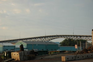
on the Cedar Street Bridge
Cedar Street Bridge
The Cedar Street Bridge carries Illinois Route 8, Illinois Route 29, and Illinois Route 116 over the Illinois River. It is about a mile and a half southwest from downtown. The bridge is a simple steel arch bridge that towers approximately 70 to above the surface of the river, and is the shortest...
.
On the southeast side of the Illinois River, it and U.S. Route 150
U.S. Route 150
U.S. Route 150 is a 571 mile long northwest-southeast United States highway, signed as east–west. It runs from U.S. Route 6 outside of Moline, Illinois to U.S. Route 25 in Mount Vernon, Kentucky .-Illinois:In the state of Illinois, U.S. 150 runs from the Quad City International Airport at U.S...
form a wrong-way concurrency. Travelling geographic northeast along the river, U.S. 150 is marked west before crossing the river to enter Peoria, and Illinois 116 is marked east. Travelling geographic southwest, U.S. 150 is marked east before branching to Morton
Morton, Illinois
Morton is a village in Tazewell County, Illinois, USA, known for its pumpkins and annual Pumpkin Festival. The population was 15,198 at the 2000 census. Morton, the home of a Caterpillar distribution facility and a Libby's pumpkin plant, is part of the Peoria, Illinois Metropolitan Statistical...
, and Illinois 116 is marked west before crossing the river to enter Peoria on its southern side.
History
U.S. Route 124 (abbreviated US 124) was a federal route that was commissioned from 1926 to 1938, and was located in IllinoisIllinois
Illinois is the fifth-most populous state of the United States of America, and is often noted for being a microcosm of the entire country. With Chicago in the northeast, small industrial cities and great agricultural productivity in central and northern Illinois, and natural resources like coal,...
, running from Peoria
Peoria, Illinois
Peoria is the largest city on the Illinois River and the county seat of Peoria County, Illinois, in the United States. It is named after the Peoria tribe. As of the 2010 census, the city was the seventh-most populated in Illinois, with a population of 115,007, and is the third-most populated...
through Biggsville
Biggsville, Illinois
Biggsville is a village in Henderson County, Illinois, United States. The population was 343 at the 2000 census. It is part of the Burlington, IA–IL Micropolitan Statistical Area...
. It was approximately 80 miles (128.7 km) in length, and followed much of the route of IL 116 prior to its decommissioning. SBI Route 116 originally ran separately from east of Ashkum to East Peoria.
US 124 was one of the original 1928 US routes in IL (since US routes didn't appear on IL maps until then). It originally went from Peoria to Galesburg, along with the then IL-8
Illinois Route 8
Illinois Route 8 is an east–west state road in central Illinois. It runs east from Illinois Route 97 south of Maquon to the intersection of U.S. Route 24 and Business U.S. 24 near Washington. Illinois 8 is long.- Route description :...
, via Farmington and Maquon on the route of the current IL 116 west from Peoria to IL-97
Illinois Route 97
Illinois Route 97 is a north–south state highway in the central and western portions of the U.S. state of Illinois. It extends from exit 98 on Interstate 55 in Springfield northwest to U.S. Highway 150 near Galesburg. It crosses over the Illinois River on a bridge west of...
, north to IL-8, west to IL-97, then northwest on IL-97 to Galesburg, with the last few miles on the current US 150
U.S. Route 150
U.S. Route 150 is a 571 mile long northwest-southeast United States highway, signed as east–west. It runs from U.S. Route 6 outside of Moline, Illinois to U.S. Route 25 in Mount Vernon, Kentucky .-Illinois:In the state of Illinois, U.S. 150 runs from the Quad City International Airport at U.S...
.
In 1934, US 124 was rerouted west on the current IL 116 to near Biggsville, where it connected to US 34
U.S. Route 34
U.S. Route 34 is an east–west United States highway that runs for 1,122 miles from north-central Colorado to the western suburbs of Chicago. Through Rocky Mountain National Park it is known as the Trail Ridge Road where it reaches 12,183 ft , making it the highest paved through highway in...
(for access to Mississippi River crossing into Iowa). West bound traffic from Peoria had a choice. Proceed along US 24
U.S. Route 24
U.S. Route 24 is one of the original United States highways of 1926. It originally ran from Pontiac, Michigan, in the east to Kansas City, Missouri, in the west. Today, the highway's eastern terminus is west of Clarkston, Michigan, at an intersection with I-75 and its western terminus is near...
to cross the Mississippi River at Quincy (south-west route) - the old Peoria to Quincy stage coach route, or take US 124 to cross the Mississippi River (US 34) at Burlington, IA (north-west route).
With the completion of Interstate 474
Interstate 474
Interstate 474 is an Interstate Highway loop route that provides a southern bypass around the north central Illinois city of Peoria. I-474's parent interstate is I-74. As the first digit of the interstate's number is even, it follows the established convention of providing a loop around a city....
as a western bypass of Peoria in 1978, an Interstate connector (Exit 3 on Interstate 474) was constructed as the eastern terminus for the proposed western Illinois expressway (Peoria to Kansas City via Macomb and Quincy). The connector provides access to IL 116.
Related route
Illinois Route 97A was a short rural spur (state maintained) that ran from U.S. Route 124 (now IL 116) south of Media south to the community of Raritan, IllinoisRaritan, Illinois
Raritan is a village in Henderson County, Illinois, United States. The population was 140 at the 2000 census. It is part of the Burlington, IA–IL Micropolitan Statistical Area.-Geography:Raritan is located at ....
.
- 1937 IL-97A was a spur off the current IL-116, Media to Raritan. This 1924 route designation was dropped.
- 1938 - US Route 124 was decommissioned and changed to Illinois 116 as an extension of that route in east central Illinois. Illinois 116 was a popular agricultural and commercial truck route from Burlington, IowaBurlington, IowaBurlington is a city in, and the county seat of Des Moines County, Iowa, United States. The population was 25,663 in the 2010 census, a decline from the 26,839 population in the 2000 census. Burlington is the center of a micropolitan area including West Burlington, Iowa and Middletown, Iowa and...
(on the Mississippi RiverMississippi RiverThe Mississippi River is the largest river system in North America. Flowing entirely in the United States, this river rises in western Minnesota and meanders slowly southwards for to the Mississippi River Delta at the Gulf of Mexico. With its many tributaries, the Mississippi's watershed drains...
) to Peoria, IllinoisPeoria, IllinoisPeoria is the largest city on the Illinois River and the county seat of Peoria County, Illinois, in the United States. It is named after the Peoria tribe. As of the 2010 census, the city was the seventh-most populated in Illinois, with a population of 115,007, and is the third-most populated...
(on the Illinois RiverIllinois RiverThe Illinois River is a principal tributary of the Mississippi River, approximately long, in the State of Illinois. The river drains a large section of central Illinois, with a drainage basin of . This river was important among Native Americans and early French traders as the principal water route...
) during World War II and through the late 1960s. This was due to: U.S. Army ammunitionAmmunitionAmmunition is a generic term derived from the French language la munition which embraced all material used for war , but which in time came to refer specifically to gunpowder and artillery. The collective term for all types of ammunition is munitions...
s arsenal at Burlington, active strip mining of coalCoalCoal is a combustible black or brownish-black sedimentary rock usually occurring in rock strata in layers or veins called coal beds or coal seams. The harder forms, such as anthracite coal, can be regarded as metamorphic rock because of later exposure to elevated temperature and pressure...
in Fulton CountyFulton County, IllinoisFulton County is a county located in the U.S. state of Illinois. According to the 2010 census, it has a population of 37,069, which is a decrease of 3.1% from 38,250 in 2000. Its county seat is Lewistown. Canton is the largest city. Both cities are southwest of Peoria, and the county is considered...
(largely south of route); farm livestock traffic to the Peoria stockyards and grain transport (corn and soybeans) to Illinois or Mississippi barge terminals.