
Interstate 294
Encyclopedia
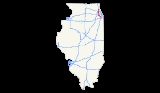
Interstate 294 is a tolled Interstate Highway in northeastern Illinois
, U.S.A.. It forms the southern portion of the Tri-State Tollway
in Illinois. I-294 runs from South Holland
at Interstates 80
and 94
, and Illinois Route 394
to Northbrook
at I-94. Interstate 294 is 53.42 miles (85.97 km) long; 5.32 miles (8.56 km) are shared with I-80. It serves as a bypass around the city of Chicago. Interstate 294 is also the longest auxiliary route of Interstate 94
, being 10 miles longer than Interstate 494
in Minneapolis-Saint Paul. Interstate 294 is also the longest auxiliary interstate highway in Illinois.
The fifth is on I-94 near Waukegan.
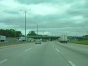
The full length of Interstate 294 is 8 lanes wide (4 lanes each direction). Prior to 2006, only the portion between O'Hare (Interstate 90) and 95th Street (U.S. 12/U.S. 20) was 8 lanes, with the remainder being 6 lanes. In 2009, The Illinois Tollway Authority completed reconstruction on the remainder of Interstate 294, expanding the tollway from 6 to 8 lanes from 95th Street to its Southern terminus at the Kingery Expressway
, and from Interstate 90 to its Northern terminus at Interstate 94
in Northbrook
.
that was completed from Gary westward and the Kingery Expressway
were originally designated as I-80, 90, and 294 from shortly after the Interstate Highway program was enacted until about 1965, when the connection between the Borman and the Indiana Toll Road
was completed, and I-90 was swapped with I-94 west of that junction (and east of where those routes share the same road in Chicago), cutting back I-294 to its current south terminus (eliminating the Indiana part of I-294). Indiana
later proposed to extend Interstate 294 east on the current Borman Expressway to Indiana State Route 912, before having it turn north at that point, west at U.S. Highway 12, and then back to I-94, most likely somewhere on the Bishop Ford Expressway near 130th Street. The request was denied.
From 1991-1993, the 23 mile portion of Interstate 294 between Interstate 90 and U.S. Route 12
/U.S. Route 20
(95th Street) was reconstructed and expanded from 6 to 8 lanes in each direction. In 2006, reconstruction to widen the Southern portion of the tollway, where I-80 and I-294 are multiplexed, was completed in conjunction with simultaneous projects on the Borman and Kingery Expressways, expanding this portion of the tollway from 6 to 8 lanes. By late 2009, additional reconstruction projects on the remainder of the tollway were completed, bringing the entire length of Interstate 294 to 8 lanes wide (4 lanes each direction).
Interstate 294 was built largely before the growth and maturation of the suburbs that run along Interstate 294. As a result, the vast majority of the interchanges are partial, or were configured to have entrance ramps feeding the toll plazas. "Gaps" between exit ramps are common, the 9.5 mile (15.3 kilometer) gap between Cicero Avenue (Illinois 50/83) and 95th Street (U.S. 12/20) being one of the more notable ones. Partial interchanges are located at Roosevelt Road
(Illinois Route 38
) (southbound exit, northbound entrance), Irving Park Road (Illinois 19) (southbound exit, northbound entrance), Touhy Avenue (northbound exit, southbound entrance), Dempster Street (U.S. 14) (northbound exit, southbound entrance), and Golf Road (Illinois 58) (southbound exit, northbound entrance). Several former partial interchanges have been converted to full interchanges, with automated toll collection facilities on the new ramps, such as at 159th Street (U.S. 6) (northbound on and southbound off added), and 95th Street (U.S. 12/20) (southbound on and northbound off added). The 79th Street exit was moved to 75th Street/Willow Springs Road, and made a complete interchange in the same manner.
, although one is being considered. This is one of the only places that two Interstate Highways cross but do not feature connecting ramps. Plans for the interchange are currently at PE 1, or preliminary engineering, but have been repeatedly put on hold due to insufficient funding since 1993. In 2006, a consortium of south suburbs again pushed the Illinois Department of Transportation
and the Tollway Authority to construct the interchange, whose construction costs are now estimated at between $235 million and $250 million USD.
.
Illinois
Illinois is the fifth-most populous state of the United States of America, and is often noted for being a microcosm of the entire country. With Chicago in the northeast, small industrial cities and great agricultural productivity in central and northern Illinois, and natural resources like coal,...
, U.S.A.. It forms the southern portion of the Tri-State Tollway
Tri-State Tollway
The Tri-State Tollway is a U.S. toll road maintained by the Illinois State Toll Highway Authority in northeastern Illinois which is considered one of the most heavily traveled highways in the country...
in Illinois. I-294 runs from South Holland
South Holland, Illinois
South Holland is a village in Cook County, Illinois, United States and serves as the seat of Thornton Township. The population was 22,147 at the 2000 census.-History:...
at Interstates 80
Interstate 80
Interstate 80 is the second-longest Interstate Highway in the United States, following Interstate 90. It is a transcontinental artery running from downtown San Francisco, California to Teaneck, New Jersey in the New York City Metropolitan Area...
and 94
Interstate 94
Interstate 94 is the northernmost east–west Interstate Highway, connecting the Great Lakes and Intermountain regions of the United States. I-94's western terminus is in Billings, Montana at a junction with Interstate 90; its eastern terminus is the U.S...
, and Illinois Route 394
Illinois Route 394
Illinois Route 394 is a four-lane state freeway that travels south from Thornton at the Interstate 294/Interstate 94/Interstate 80 interchange to Illinois Route 1 south of Steger and Crete. Before taking the Illinois 394 route, it was known as Illinois 1...
to Northbrook
Northbrook, Illinois
Northbrook is a village located at the northern edge of Cook County, Illinois, which is also a North Shore suburb of Chicago. The population was 33,170 at the 2010 census....
at I-94. Interstate 294 is 53.42 miles (85.97 km) long; 5.32 miles (8.56 km) are shared with I-80. It serves as a bypass around the city of Chicago. Interstate 294 is also the longest auxiliary route of Interstate 94
Interstate 94
Interstate 94 is the northernmost east–west Interstate Highway, connecting the Great Lakes and Intermountain regions of the United States. I-94's western terminus is in Billings, Montana at a junction with Interstate 90; its eastern terminus is the U.S...
, being 10 miles longer than Interstate 494
Interstate 494
Interstate 494 is a loop route making up part of a beltway of Interstate 94, circling through the southern and western portions of the Minneapolis – Saint Paul metropolitan area in Minnesota...
in Minneapolis-Saint Paul. Interstate 294 is also the longest auxiliary interstate highway in Illinois.
Route description
Interstate 294 has four of the Tri-State Tollway's five mainline barriers. These are located at:- 163rd Street
- 82nd Street (Southbound)/83rd Street (Northbound)
- Cermak RoadCermak RoadCermak Road, formerly 22nd Street, is a major east-west artery on Chicago's south side and western suburbs. It is named for assassinated Chicago mayor Anton Cermak.-Points of interest:...
- Irving Park Road (Illinois Route 19Illinois Route 19Illinois Route 19 is a major east–west arterial road in northeastern Illinois, United States. It runs from Illinois Route 25 in Elgin, to Lake Shore Drive on the north side of Chicago. Illinois 19 is long...
) (Southbound)/ Touhy Ave. (Northbound)
The fifth is on I-94 near Waukegan.
The full length of Interstate 294 is 8 lanes wide (4 lanes each direction). Prior to 2006, only the portion between O'Hare (Interstate 90) and 95th Street (U.S. 12/U.S. 20) was 8 lanes, with the remainder being 6 lanes. In 2009, The Illinois Tollway Authority completed reconstruction on the remainder of Interstate 294, expanding the tollway from 6 to 8 lanes from 95th Street to its Southern terminus at the Kingery Expressway
Kingery Expressway
The Robert Kingery Expressway, formerly called the Tri-State Highway, is a three-mile-long , eight-lane expressway in northeastern Illinois...
, and from Interstate 90 to its Northern terminus at Interstate 94
Interstate 94
Interstate 94 is the northernmost east–west Interstate Highway, connecting the Great Lakes and Intermountain regions of the United States. I-94's western terminus is in Billings, Montana at a junction with Interstate 90; its eastern terminus is the U.S...
in Northbrook
Northbrook, Illinois
Northbrook is a village located at the northern edge of Cook County, Illinois, which is also a North Shore suburb of Chicago. The population was 33,170 at the 2010 census....
.
History
The portion of the Borman ExpresswayBorman Expressway
The Frank Borman Expressway is an east–west highway in the northwest part of the U.S. state of Indiana, named after astronaut and former Eastern Airlines CEO Frank Borman. The expressway consists of parts of Interstate 80 , I-94, and U.S. Highway 6 , as well as a short section of US 41...
that was completed from Gary westward and the Kingery Expressway
Kingery Expressway
The Robert Kingery Expressway, formerly called the Tri-State Highway, is a three-mile-long , eight-lane expressway in northeastern Illinois...
were originally designated as I-80, 90, and 294 from shortly after the Interstate Highway program was enacted until about 1965, when the connection between the Borman and the Indiana Toll Road
Indiana Toll Road
The Indiana Toll Road, officially the Indiana East–West Toll Road, is a toll road that runs for east–west across northern Indiana from the Illinois state line to the Ohio state line...
was completed, and I-90 was swapped with I-94 west of that junction (and east of where those routes share the same road in Chicago), cutting back I-294 to its current south terminus (eliminating the Indiana part of I-294). Indiana
Indiana
Indiana is a US state, admitted to the United States as the 19th on December 11, 1816. It is located in the Midwestern United States and Great Lakes Region. With 6,483,802 residents, the state is ranked 15th in population and 16th in population density. Indiana is ranked 38th in land area and is...
later proposed to extend Interstate 294 east on the current Borman Expressway to Indiana State Route 912, before having it turn north at that point, west at U.S. Highway 12, and then back to I-94, most likely somewhere on the Bishop Ford Expressway near 130th Street. The request was denied.
From 1991-1993, the 23 mile portion of Interstate 294 between Interstate 90 and U.S. Route 12
U.S. Route 12 in Illinois
In the U.S. state of Illinois, U.S. Route 12 is an arterial highway that runs northwest to southeast through the Chicago metropolitan area. It runs from the Wisconsin border north of Richmond to the Indiana border at Chicago with U.S. Routes 12 and 41, also at the foot of an onramp to the Indiana...
/U.S. Route 20
U.S. Route 20 in Illinois
In the U.S. state of Illinois, U.S. Route 20 is a major arterial highway that runs from the Iowa state line at East Dubuque at the northwestern tip of Illinois, to the Indiana state line at Chicago south of the Chicago Skyway. A distance of .For its entire length, US 20 is designated as the...
(95th Street) was reconstructed and expanded from 6 to 8 lanes in each direction. In 2006, reconstruction to widen the Southern portion of the tollway, where I-80 and I-294 are multiplexed, was completed in conjunction with simultaneous projects on the Borman and Kingery Expressways, expanding this portion of the tollway from 6 to 8 lanes. By late 2009, additional reconstruction projects on the remainder of the tollway were completed, bringing the entire length of Interstate 294 to 8 lanes wide (4 lanes each direction).
Interstate 294 was built largely before the growth and maturation of the suburbs that run along Interstate 294. As a result, the vast majority of the interchanges are partial, or were configured to have entrance ramps feeding the toll plazas. "Gaps" between exit ramps are common, the 9.5 mile (15.3 kilometer) gap between Cicero Avenue (Illinois 50/83) and 95th Street (U.S. 12/20) being one of the more notable ones. Partial interchanges are located at Roosevelt Road
Roosevelt Road
Roosevelt Road is a major east-west thoroughfare in the city of Chicago, Illinois, and its western suburbs. It is 1200 South in the city's street numbering system, but only one mile south of Madison Street...
(Illinois Route 38
Illinois Route 38
Illinois Route 38 is an east–west state road that runs across northern Illinois. It runs from U.S. Route 52 in downtown Dixon to U.S. Highways 12, 20, and 45 in Westchester. This is a distance of . As Roosevelt Road it continues through Forest Park and into Cicero and Chicago before...
) (southbound exit, northbound entrance), Irving Park Road (Illinois 19) (southbound exit, northbound entrance), Touhy Avenue (northbound exit, southbound entrance), Dempster Street (U.S. 14) (northbound exit, southbound entrance), and Golf Road (Illinois 58) (southbound exit, northbound entrance). Several former partial interchanges have been converted to full interchanges, with automated toll collection facilities on the new ramps, such as at 159th Street (U.S. 6) (northbound on and southbound off added), and 95th Street (U.S. 12/20) (southbound on and northbound off added). The 79th Street exit was moved to 75th Street/Willow Springs Road, and made a complete interchange in the same manner.
Future
, Interstate 294 has no interchange on Interstate 57Interstate 57
Interstate 57 is an Interstate Highway in Missouri and Illinois that parallels the old Illinois Central rail line for much of its route. It goes from Miner, Missouri, at Interstate 55 to Chicago, Illinois, at Interstate 94. I-57 essentially serves as a shortcut route for travelers headed between...
, although one is being considered. This is one of the only places that two Interstate Highways cross but do not feature connecting ramps. Plans for the interchange are currently at PE 1, or preliminary engineering, but have been repeatedly put on hold due to insufficient funding since 1993. In 2006, a consortium of south suburbs again pushed the Illinois Department of Transportation
Illinois Department of Transportation
The Illinois Department of Transportation is a state agency in charge of state-maintained public roadways of the U.S. state of Illinois. In addition, IDOT provides funding for rail, public transit and airport projects and administers fuel tax and federal funding to local juridictions in the...
and the Tollway Authority to construct the interchange, whose construction costs are now estimated at between $235 million and $250 million USD.
Exit list
The entire route is in Cook CountyCook County, Illinois
Cook County is a county in the U.S. state of Illinois, with its county seat in Chicago. It is the second most populous county in the United States after Los Angeles County. The county has 5,194,675 residents, which is 40.5 percent of all Illinois residents. Cook County's population is larger than...
.
| Location | Plaza # |
Mile |
Destinations | Notes |
|---|---|---|---|---|
| South Holland South Holland, Illinois South Holland is a village in Cook County, Illinois, United States and serves as the seat of Thornton Township. The population was 22,147 at the 2000 census.-History:... |
0 | – Indiana Indiana Indiana is a US state, admitted to the United States as the 19th on December 11, 1816. It is located in the Midwestern United States and Great Lakes Region. With 6,483,802 residents, the state is ranked 15th in population and 16th in population density. Indiana is ranked 38th in land area and is... |
Southbound exit and northbound entrance | |
| 0 | Southbound exit and northbound entrance | |||
| 1 | Chicago Southland Lincoln Oasis | |||
| East Hazel Crest East Hazel Crest, Illinois East Hazel Crest is a village in Cook County, Illinois, in the United States. As of the 2000 census, the village population was 1,607.-Geography:East Hazel Crest is located at .... |
47 | 3 | ||
| 4 | Dixie Highway Dixie Highway The Dixie Highway was a United States automobile highway, first planned in 1914 to connect the US Midwest with the Southern United States. It was part of the National Auto Trail system, and grew out of an earlier Miami to Montreal highway. The final result is better understood as a small network of... |
Southbound exit and northbound entrance | ||
| Hazel Crest Hazel Crest, Illinois Hazel Crest is a village in Cook County, Illinois, United States. The population was 14,816 at the 2000 census. Despite being primarily located in Bremen Township, the village is also located in Rich Township south of 183rd Street and Thornton Township east of I-80/94 The Village is located in... |
43-45 | 5 | – Iowa Iowa Iowa is a state located in the Midwestern United States, an area often referred to as the "American Heartland". It derives its name from the Ioway people, one of the many American Indian tribes that occupied the state at the time of European exploration. Iowa was a part of the French colony of New... |
North end of I-80 overlap |
| 41 | 6 | 163rd Street Toll Plaza | ||
| Markham Markham, Illinois Markham is a city in Cook County, Illinois, United States. The population was 12,620 at the 2000 census.-Geography:Markham is located at .According to the United States Census Bureau, the city has a total area of , all of it land.... |
40 | 6.5 | ||
| Alsip Alsip, Illinois Alsip is a village in Cook County, Illinois, United States. The population was 19,725 at the 2000 census. It is a suburb of Chicago.Alsip was settled in the 1830s by German and Dutch farmers. The village is named after Frank Alsip, the owner of a brickyard that opened there in 1885... |
12 | |||
| Hickory Hills Hickory Hills, Illinois Hickory Hills is a city in Cook County, Illinois, United States. The population was 13,926 at the 2000 census.-Geography:Hickory Hills is located at .... |
38 | 17.5 | ||
| 39 | 19.5 | 83rd Street Toll Plaza (northbound) | ||
| 36 | 20 | 82nd Street Toll Plaza (southbound) | ||
| Justice Justice, Illinois Justice is a village in Cook County, Illinois, United States established in 1911. The population was 12,850 as of 2006.-Geography:According to the United States Census Bureau, the village has a total area of , of which, of it is land and of it is water.A major road running through the town is... |
21 | Southbound entrance only | ||
| Mile-Long Bridge Mile-Long Bridge The Mile-Long Bridge is the colloquial name for a long bridge in the northeastern part of the U.S. state of Illinois. The bridge carries Interstate 294 over the Des Plaines River, the Chicago Ship and Sanitary Canal, numerous railroad lines, and the United Parcel Service intermodal facility... over Des Plaines River Des Plaines River The Des Plaines River is a river that flows southward for through southern Wisconsin and northern Illinois in the U.S. Midwest, eventually meeting the Kankakee River west of Channahon to form the Illinois River, a tributary of the Mississippi River.... |
||||
| Hodgkins Hodgkins, Illinois Hodgkins is a village in Cook County, Illinois, United States. The population was 2,134 at the 2000 census.A large United Parcel Service sorting facility, known as CACH, is located partly in Hodgkins and partly in nearby Willow Springs on the outskirts of Chicago... |
34 | 22 | 75th Street, Willow Springs Road (10800 West) | |
| Indian Head Park Indian Head Park, Illinois Indian Head Park is a village in Cook County, Illinois slightly north of the intersection of Interstate 294 and Interstate 55. The village is south of Western Springs, north of Burr Ridge, and west of Countryside. The population was 3,685 at the 2000 census... |
37 | 23 | , St. Louis St. Louis, Missouri St. Louis is an independent city on the eastern border of Missouri, United States. With a population of 319,294, it was the 58th-largest U.S. city at the 2010 U.S. Census. The Greater St... |
No southbound entrance from I-55 south |
| 24 | Wolf Road (11200 West) | Northbound exit and southbound entrance | ||
| Hinsdale Hinsdale, Illinois Hinsdale is a suburb of Chicago, Illinois; it is located partly in Cook County and mainly in DuPage County in the U.S. state of Illinois. The population was 17,349 at the 2000 census. The town's ZIP code is 60521. The town has a rolling, wooded topography, with a quaint downtown and is a 30-minute... |
25 | Hinsdale Oasis | ||
| Western Springs Western Springs, Illinois Western Springs is a suburb of Chicago located in Cook County, Illinois. As of the 2000 census, the village had a total population of 12,493. It is twinned with Rugeley, United Kingdom.... |
28 | |||
| Hillside Hillside, Illinois Hillside is a village in Cook County, Illinois, United States. The population was 8,155 at the 2000 census.One notable landmark in Hillside is the Mount Carmel Cemetery. On the grounds of the cemetery are the graves of a number of organized crime figures, such as Al Capone and Dion O'Bannion... |
29 | Northbound exit and southbound entrance | ||
| 29.5 | Cermak Road Cermak Road Cermak Road, formerly 22nd Street, is a major east-west artery on Chicago's south side and western suburbs. It is named for assassinated Chicago mayor Anton Cermak.-Points of interest:... , 22nd Street |
Southbound exit and northbound entrance | ||
| 35 | 30 | Cermak Road Toll Plaza | ||
| 30.5 | Northbound exit and southbound entrance | |||
| 31 | Southbound exit and northbound entrance | |||
| 32 | ||||
| Berkeley Berkeley, Illinois Berkeley is a village located in Cook County, Illinois, United States. Incorporated in 1924, the population at the 2000 census was 5,245.The town has a commuter railroad station on Metra's Union Pacific/West Line with service to downtown Chicago.-Geography:... |
34 | |||
| Franklin Park Franklin Park, Illinois Franklin Park is a village in Cook County, Illinois, United States. The population was 19,800 at the 2004 census.-Geography:Franklin Park is located at .... |
38 | O'Hare Oasis | ||
| 38.5 | Southbound exit and northbound entrance | |||
| 33 | 39 | Irving Park Toll Plaza (southbound) | ||
| Rosemont Rosemont, Illinois Rosemont is a village in Cook County, Illinois, United States located immediately northwest of Chicago. The village was incorporated in 1956, though it had been settled long before that... |
32 | 40 | ||
| 31 | 41 | |||
| Park Ridge Park Ridge, Illinois -Climate:-Demographics:As of the census of 2000, there were 37,775 people, 14,219 households, and 10,465 families residing in the city. The population density was 5,374.6 people per square mile . There were 14,646 housing units at an average density of 2,083.8 per square mile... |
29 | 42 | Touhy Avenue Touhy Avenue Touhy Avenue is a major thoroughfare throughout northern Chicago, Illinois as well as the north and northwestern suburbs of the city. It is named for Patrick L. Touhy, a subdivider who was also the son-in-law of Phillip Rogers, an early settler who helped develop Rogers Park... Toll Plaza (northbound) |
|
| 42 | Touhy Avenue Touhy Avenue Touhy Avenue is a major thoroughfare throughout northern Chicago, Illinois as well as the north and northwestern suburbs of the city. It is named for Patrick L. Touhy, a subdivider who was also the son-in-law of Phillip Rogers, an early settler who helped develop Rogers Park... |
Northbound exit and southbound entrance | ||
| Des Plaines Des Plaines, Illinois Des Plaines is a city in Cook County, Illinois, United States. It has adopted the official nickname of "City of Destiny." As of the 2000 census, the city had a total population of 58,720. It is a suburb of Chicago, and is next to O'Hare International Airport... |
44.5 | Northbound exit and southbound entrance | ||
| 28 | 45 | Southbound exit and northbound entrance | ||
| Glenview Glenview, Cook County, Illinois Glenview is a suburban village located approximately north of downtown Chicago in Cook County, Illinois. As of the 2000 census, the village population was 41,847... |
27 | 49 | Willow Road | |
| Northbrook Northbrook, Illinois Northbrook is a village located at the northern edge of Cook County, Illinois, which is also a North Shore suburb of Chicago. The population was 33,170 at the 2010 census.... |
24 | 50.5- 53 |
||