

List of Florida hurricanes (2000-present)
Encyclopedia

Atlantic hurricane
North Atlantic tropical cyclones usually form in the northern hemisphere summer or fall. Tropical cyclones can be categorized by intensity. Tropical storms have one-minute maximum sustained winds of at least 39 mph , while hurricanes have one-minute maximum sustained exceeding 74 mph...
; as of 2011, 58 tropical
Tropical cyclone
A tropical cyclone is a storm system characterized by a large low-pressure center and numerous thunderstorms that produce strong winds and heavy rain. Tropical cyclones strengthen when water evaporated from the ocean is released as the saturated air rises, resulting in condensation of water vapor...
or subtropical cyclone
Subtropical cyclone
A subtropical cyclone is a weather system that has some characteristics of a tropical and an extratropical cyclone. As early as the 1950s, meteorologists were unclear whether they should be characterized as tropical or extratropical cyclones. They were officially recognized by the National...
s have affected the U.S. state
U.S. state
A U.S. state is any one of the 50 federated states of the United States of America that share sovereignty with the federal government. Because of this shared sovereignty, an American is a citizen both of the federal entity and of his or her state of domicile. Four states use the official title of...
of Florida
Florida
Florida is a state in the southeastern United States, located on the nation's Atlantic and Gulf coasts. It is bordered to the west by the Gulf of Mexico, to the north by Alabama and Georgia and to the east by the Atlantic Ocean. With a population of 18,801,310 as measured by the 2010 census, it...
. Collectively, cyclones in Florida during the time period resulted in over $64 billion in damage (2008 USD
United States dollar
The United States dollar , also referred to as the American dollar, is the official currency of the United States of America. It is divided into 100 smaller units called cents or pennies....
). Additionally, tropical cyclones in Florida were responsible for 69 direct fatalities and at least 82 indirect casualties during the period. Eight cyclones affected the state in both 2003
1985 Atlantic hurricane season
The 1985 Atlantic hurricane season had the most U.S. landfalling tropical cyclones since 1916. The season officially began on June 1, 1985, and lasted until November 30, 1985...
and 2005
2005 Atlantic hurricane season
The 2005 Atlantic hurricane season was the most active Atlantic hurricane season in recorded history, repeatedly shattering numerous records. The impact of the season was widespread and ruinous with an estimated 3,913 deaths and record damage of about $159.2 billion...
, which were the years with the most tropical cyclones impacting the state. Every year included at least one tropical cyclone affecting the state. During the 2004 season, more than one out of every five houses in the state received damage.
The strongest hurricane to hit the state during the time period was Hurricane Charley
Hurricane Charley
Hurricane Charley was the third named storm, the second hurricane, and the second major hurricane of the 2004 Atlantic hurricane season. Charley lasted from August 9 to August 15, and at its peak intensity it attained 150 mph winds, making it a strong Category 4 hurricane on the...
, which was the strongest hurricane to strike the United States since Hurricane Andrew
Hurricane Andrew
Hurricane Andrew was the third Category 5 hurricane to make landfall in the United States, after the Labor Day Hurricane of 1935 and Hurricane Camille in 1969. Andrew was the first named storm and only major hurricane of the otherwise inactive 1992 Atlantic hurricane season...
. Additionally, Hurricanes Jeanne
Hurricane Jeanne
Hurricane Jeanne was the deadliest hurricane in the 2004 Atlantic hurricane season. It was the tenth named storm, the seventh hurricane, and the fifth major hurricane of the season, as well as the third hurricane and fourth named storm of the season to make landfall in Florida...
, Dennis
Hurricane Dennis
Hurricane Dennis was an early-forming major hurricane in the Caribbean and Gulf of Mexico during the very active 2005 Atlantic hurricane season. Dennis was the fourth named storm, second hurricane, and first major hurricane of the season...
, and Wilma
Hurricane Wilma
Hurricane Wilma was the most intense tropical cyclone ever recorded in the Atlantic basin. Wilma was the twenty-second storm , thirteenth hurricane, sixth major hurricane, and fourth Category 5 hurricane of the record-breaking 2005 season...
made landfall
Landfall (meteorology)
Landfall is the event of a tropical cyclone or a waterspout coming onto land after being over water. When a waterspout makes landfall it is reclassified as a tornado, which can then cause damage inland...
on the state as major hurricanes
Tropical cyclone scales
Tropical systems are officially ranked on one of several tropical cyclone scales according to their maximum sustained winds and in what oceanic basin they are located...
.
2000
- August 23, 2000 – The National Hurricane CenterNational Hurricane CenterThe National Hurricane Center , located at Florida International University in Miami, Florida, is the division of the National Weather Service responsible for tracking and predicting weather systems within the tropics between the Prime Meridian and the 140th meridian west poleward to the 30th...
forecasts Hurricane DebbyHurricane Debby (2000)Hurricane Debby was a minimal Category 1 hurricane that formed in mid-to-late August of the year 2000. Debby formed east of the Windward Islands on August 19, 2000, becoming the seventh tropical cyclone of the 2000 Atlantic hurricane season. The storm strengthened to a hurricane the next day,...
to pass through the Florida KeysFlorida KeysThe Florida Keys are a coral archipelago in southeast United States. They begin at the southeastern tip of the Florida peninsula, about south of Miami, and extend in a gentle arc south-southwest and then westward to Key West, the westernmost of the inhabited islands, and on to the uninhabited Dry...
as a Category 2 hurricaneSaffir-Simpson Hurricane ScaleThe Saffir–Simpson Hurricane Scale , or the Saffir–Simpson Hurricane Wind Scale , classifies hurricanes — Western Hemisphere tropical cyclones that exceed the intensities of tropical depressions and tropical storms — into five categories distinguished by the intensities of their sustained winds...
, with one computer model predicting a Category 4 hurricane in the area. This results in officials declaring a mandatory evacuation for all non-residents in the keys, causing a significant loss of tourism revenue for Monroe CountyMonroe County, FloridaMonroe County is a county located in the state of Florida. As of 2000, the population was 79,589. The U.S. Census Bureau 2006 estimate for the county was 74,737....
. Debby dissipates before hitting the area, though its remnants produce heavy rainfall across southern Florida. - September 9, 2000 – Moisture from Tropical Depression Nine produce light rainfall in the western Florida PanhandleFlorida PanhandleThe Florida Panhandle, an informal, unofficial term for the northwestern part of Florida, is a strip of land roughly 200 miles long and 50 to 100 miles wide , lying between Alabama on the north and the west, Georgia also on the north, and the Gulf of Mexico to the south. Its eastern boundary is...
. - September 18, 2000 – Tropical Storm GordonHurricane Gordon (2000)Hurricane Gordon was one of two U.S. landfalling tropical storms of the 2000 Atlantic hurricane season, and was the 7th named storm and 4th hurricane of the 2000 Atlantic hurricane season. Gordon was a category 1 hurricane over the Gulf of Mexico but weakened to a tropical storm before making...
makes landfall on Cedar KeyCedar Key, FloridaCedar Key is a city in Levy County, Florida, United States. The population was 790 at the 2000 census. According to the U.S Census estimates of 2005, the city had a population of 958. The Cedar Keys are a cluster of islands close to the mainland. Most of the developed area of the city has been on...
, dropping up to 9.48 inches (240 mm) of rainfall in MayoMayo, FloridaMayo is a town and the only municipality in Lafayette County, Florida, United States. The population was 988 at the 2000 census. As of 2004, the population recorded by the U.S. Census Bureau is 1,009...
. Hundreds of homes are damaged from floodwaters or fallen trees, and damage in the state amounts to at least $5.1 million (2000 USD, $6.4 million 2008 USD). A surfer drowns in rough seas near PensacolaPensacola, FloridaPensacola is the westernmost city in the Florida Panhandle and the county seat of Escambia County, Florida, United States of America. As of the 2000 census, the city had a total population of 56,255 and as of 2009, the estimated population was 53,752...
. - September 22, 2000 – Tropical Storm HeleneTropical Storm Helene (2000)Tropical Storm Helene was a weak tropical cyclone that made landfall in the United States as a minimal tropical storm. The tropical system was the twelfth tropical cyclone and eighth tropical storm of the 2000 Atlantic hurricane season. After becoming a tropical depression east of the Windward...
hits near PensacolaPensacola, FloridaPensacola is the westernmost city in the Florida Panhandle and the county seat of Escambia County, Florida, United States of America. As of the 2000 census, the city had a total population of 56,255 and as of 2009, the estimated population was 53,752...
, damaging hundreds of homes from floodwaters. Monetary damage totals over $1 million (2000 USD, $1.3 million 2008 USD). - October 3, 2000 – The precursor disturbance to Tropical Storm LeslieTropical Storm Leslie (2000)Tropical Storm Leslie was a weak, short-lived tropical cyclone that was never well-organized; however, its precursor was costlier than any other tropical cyclone in the 2000 Atlantic hurricane season. The twelfth named storm of the season, Leslie formed on October 4 over eastern Florida as a...
produces 10—20 inches (255–510 mm) of rainfall across southeastern Florida, flooding about 93,000 houses. The flooding causes $950 million in damage (2000 USD, $1.2 billion 2008 USD), along with three indirect deaths.
2001
.jpg)
- June 12, 2001 – Subtropical Depression AllisonTropical Storm AllisonTropical Storm Allison was a tropical storm that devastated southeast Texas in June of the 2001 Atlantic hurricane season. The first storm of the season, Allison lasted an unusually long period of time for a June storm, remaining tropical or subtropical for 15 days...
moves through AlabamaAlabamaAlabama is a state located in the southeastern region of the United States. It is bordered by Tennessee to the north, Georgia to the east, Florida and the Gulf of Mexico to the south, and Mississippi to the west. Alabama ranks 30th in total land area and ranks second in the size of its inland...
and GeorgiaGeorgia (U.S. state)Georgia is a state located in the southeastern United States. It was established in 1732, the last of the original Thirteen Colonies. The state is named after King George II of Great Britain. Georgia was the fourth state to ratify the United States Constitution, on January 2, 1788...
, with its outer rainbandRainbandA rainband is a cloud and precipitation structure associated with an area of rainfall which is significantly elongated. Rainbands can be stratiform or convective, and are generated by differences in temperature. When noted on weather radar imagery, this precipitation elongation is referred to as...
s producing up to 10.1 inches (357 mm) of rain at the Tallahassee Regional AirportTallahassee Regional AirportTallahassee Regional Airport is a city-owned public-use airport located four nautical miles southwest of the central business district of Tallahassee, a city in Leon County, Florida, United States.- History :...
. The rainfall destroys 10 homes and damages 599 others, with monetary damage totaling $20 million (2001 USD, $24 million 2008 USD). Eight people die in the state, five of which due to rip currentRip currentA rip current, commonly referred to by the misnomer rip tide, is a strong channel of water flowing seaward from near the shore, typically through the surf line. Typical flow is at 0.5 metres per second , and can be as fast as 2.5 metres per second...
s. - August 6, 2001 – After meandering for several days in the eastern Gulf of MexicoGulf of MexicoThe Gulf of Mexico is a partially landlocked ocean basin largely surrounded by the North American continent and the island of Cuba. It is bounded on the northeast, north and northwest by the Gulf Coast of the United States, on the southwest and south by Mexico, and on the southeast by Cuba. In...
, Tropical Storm BarryTropical Storm Barry (2001)Tropical Storm Barry was a strong tropical storm that made landfall on the Florida Panhandle during August 2001. The third tropical cyclone and second named storm of the 2001 Atlantic hurricane season, Barry developed from a tropical wave that moved off the coast of Africa on July 24 and tracked...
makes landfall at Santa Rosa Beach, producing heavy rainfall across much of Florida which peaks at 11.7 inches (297 mm) in StuartStuart, FloridaStuart is the only incorporated city of Martin County, Florida, on Florida's Treasure Coast. The population was 14,633 at the 2000 census. As of 2007, the population recorded by the U.S. Census Bureau is 15,964....
. The storm kills two in the state and leaves $1.5 million in damage (2001 USD, $1.8 million 2008 USD). - September 14, 2001 – Tropical Storm GabrielleHurricane Gabrielle (2001)Hurricane Gabrielle was a moderate category 1 hurricane which made landfall near Venice, Florida as a strong tropical storm. The eighth tropical cyclone, seventh named storm, and third hurricane of the 2001 Atlantic hurricane season, Gabrielle developed from a non-tropical low-to mid-level trough...
hits VeniceVenice, FloridaVenice is a city in Sarasota County, Florida, United States. According to the U.S. Census Bureau's 2007 estimates, the city had a population of 21,015. It is noted for its large snowbird population. Its newspaper is the Venice Gondolier Sun...
, dropping moderate to heavy rainfall including a peak total of 15.1 inches (384 mm) in ParrishParrish, FloridaParrish is an unincorporated community in Manatee County, Florida, United States. It is located near the intersection of US 301 and State Road 62...
. The combination of flooding from rainfall and gusty winds causes $230 million in damage (2001 USD, $280 million 2008 USD) and one direct death, and high waves from the storm indirectly kills a person in the Florida KeysFlorida KeysThe Florida Keys are a coral archipelago in southeast United States. They begin at the southeastern tip of the Florida peninsula, about south of Miami, and extend in a gentle arc south-southwest and then westward to Key West, the westernmost of the inhabited islands, and on to the uninhabited Dry...
. - November 5, 2001 – Hurricane MichelleHurricane MichelleHurricane Michelle was the thirteenth named storm and the strongest tropical cyclone of the 2001 Atlantic hurricane season. Michelle developed from a tropical wave that moved across the Atlantic, and formed into Tropical Depression Fifteen on the October 29. The depression slowly intensified as...
passes to the south of the state, dropping up to 4.99 inches (127 mm) of rainfall. The hurricane spawns two tornadoes, resulting in minor damage.
2002
.jpg)
- July 13, 2002 – The precursor disturbance to Tropical Storm ArthurTropical Storm Arthur (2002)Tropical Storm Arthur was the first tropical cyclone of the 2002 Atlantic hurricane season. The origins of the storm are believed to have been from a decaying cold front in the Gulf of Mexico, which dropped light to moderate rainfall across the southeastern United States...
moves across the Florida PanhandleFlorida PanhandleThe Florida Panhandle, an informal, unofficial term for the northwestern part of Florida, is a strip of land roughly 200 miles long and 50 to 100 miles wide , lying between Alabama on the north and the west, Georgia also on the north, and the Gulf of Mexico to the south. Its eastern boundary is...
and produces heavy amounts of precipitation peaking at 4.79 inches (122 mm) in two locations. - August 4, 2002 – High surf from Tropical Storm BerthaTropical Storm Bertha (2002)Tropical Storm Bertha was a minimal tropical storm that made landfall twice along the Gulf Coast of the United States in August 2002. The second tropical storm of the 2002 Atlantic hurricane season, Bertha developed in the northern Gulf of Mexico out of a trough of low pressure that extended into...
kills one person at Perdido Key State Recreation AreaPerdido Key State Recreation AreaPerdido Key State Park is a Florida State Park located on a barrier island fifteen miles southwest of Pensacola, off S.R. 292, in northwestern Florida. The address is 12301 Gulf Beach Highway.- Perdido Key State Park :...
. - September 4, 2002 – Tropical Storm EdouardTropical Storm Edouard (2002)Tropical Storm Edouard was the first of eight tropical cyclones to develop in September 2002, at the time the highest on record for any month. The fifth tropical storm of the 2002 Atlantic hurricane season, Edouard developed into a tropical cyclone on September 1 from an area of convection in...
hits near Ormond BeachOrmond Beach, FloridaOrmond Beach is a city in Volusia County, Florida, United States. The population was 36,301 at the 2000 census. As of 2004, the population recorded by the U.S. Census Bureau is 37,929. Ormond Beach is the northern neighbor of Daytona Beach and is home to Tomoka State Park.-History:Ormond Beach was...
as a minimal tropical storm. While crossing the peninsula from east to west, the storm drops up to 7.64 inches (194 mm) of rain in DeSoto CityDeSoto County, FloridaDeSoto County is a county located in the U.S. state of Florida. As of 2000, the population was 32,209. The U.S. Census Bureau 2005 estimate for the county is 35,406 . Its county seat is Arcadia, Florida. The county comprises the Arcadia, Florida Micropolitan Statistical Area.- History :DeSoto...
, resulting in some flooding and minimal damage. - September 14, 2002 – Tropical Storm HannaTropical Storm Hanna (2002)Tropical Storm Hanna was a moderately strong tropical storm that affected the Gulf Coast and Southeastern regions of the United States. The tenth tropical cyclone and ninth named storm of the 2002 Atlantic hurricane season, Hanna formed through the complex interaction of a surface trough, a...
strikes near the state border of AlabamaAlabamaAlabama is a state located in the southeastern region of the United States. It is bordered by Tennessee to the north, Georgia to the east, Florida and the Gulf of Mexico to the south, and Mississippi to the west. Alabama ranks 30th in total land area and ranks second in the size of its inland...
and MississippiMississippiMississippi is a U.S. state located in the Southern United States. Jackson is the state capital and largest city. The name of the state derives from the Mississippi River, which flows along its western boundary, whose name comes from the Ojibwe word misi-ziibi...
and produces moderate precipitation across the state. Three people die in rip currents from the storm. - September 26, 2002 – Tropical Storm IsidoreHurricane IsidoreHurricane Isidore was the ninth named storm and the second hurricane in the 2002 Atlantic hurricane season. Isidore was the fifth of eight named storms to occur in September. The tropical cyclone peaked as a Category 3 hurricane, causing damage as well as four fatalities in Jamaica, Cuba, Mexico,...
hits southern LouisianaLouisianaLouisiana is a state located in the southern region of the United States of America. Its capital is Baton Rouge and largest city is New Orleans. Louisiana is the only state in the U.S. with political subdivisions termed parishes, which are local governments equivalent to counties...
, though its large circulation drops rainfall across the state peaking at 9.1 inches (231 mm) in PensacolaPensacola, FloridaPensacola is the westernmost city in the Florida Panhandle and the county seat of Escambia County, Florida, United States of America. As of the 2000 census, the city had a total population of 56,255 and as of 2009, the estimated population was 53,752...
. Tornadoes spawned by the storm damage multiple mobile homes, with monetary damage across the state totaling over $11 million (2002 USD, $13 million 2008 USD). - October 3, 2002 – Hurricane LiliHurricane LiliHurricane Lili was the deadliest and costliest hurricane of the 2002 Atlantic hurricane season for the United States. Lili was the twelfth named storm, fourth hurricane, and second major hurricane of the 2002 Atlantic hurricane season. The storm developed from a tropical disturbance in the open...
makes landfall on southern LouisianaLouisianaLouisiana is a state located in the southern region of the United States of America. Its capital is Baton Rouge and largest city is New Orleans. Louisiana is the only state in the U.S. with political subdivisions termed parishes, which are local governments equivalent to counties...
, and drops 1.04 inches (26 mm) of rainfall in PensacolaPensacola, FloridaPensacola is the westernmost city in the Florida Panhandle and the county seat of Escambia County, Florida, United States of America. As of the 2000 census, the city had a total population of 56,255 and as of 2009, the estimated population was 53,752...
. - October 11, 2002 – Tropical Storm KyleHurricane Kyle (2002)Hurricane Kyle was the fourth longest-lived Atlantic tropical or subtropical cyclone on record. The eleventh named storm and third hurricane of the 2002 Atlantic hurricane season, Kyle developed as a subtropical cyclone on September 20 to the east-southeast of Bermuda. Looping westward, it...
turns northward to the east of the state, producing up to 2.05 inches (52 mm) of precipitation in Fernandina BrachFernandina Beach, FloridaFernandina Beach is a city in Nassau County in the state of Florida in the United States of America and on Amelia Island. It is a part of Greater Jacksonville and is among Florida's northernmost cities. The area was first inhabited by the Timucuan Indian tribe...
and a light storm surgeStorm surgeA storm surge is an offshore rise of water associated with a low pressure weather system, typically tropical cyclones and strong extratropical cyclones. Storm surges are caused primarily by high winds pushing on the ocean's surface. The wind causes the water to pile up higher than the ordinary sea...
.
2003
.jpg)
- April 20, 2003 – Swells from Tropical Storm AnaTropical Storm Ana (2003)Tropical Storm Ana was the only tropical cyclone on record in the Atlantic basin to form during the month of April. The first tropical cyclone of the season, it developed as a subtropical cyclone from a non-tropical low on April 20 to the west of Bermuda...
capsize a boat near JupiterJupiter, FloridaJupiter is a town located in Palm Beach County, Florida. As of the 2000 census, the town had a total population of 39,328. The estimate population for 2009 is 50,606. As of 2006, the population had grown to 50,028, according to the University of Florida, Bureau of Economic and Business Research....
, killing two of the four passengers aboard. - June 30, 2003 – Tropical Storm BillTropical Storm Bill (2003)Tropical Storm Bill was a tropical storm that affected the Gulf Coast of the United States in the summer of 2003. The second storm of the 2003 Atlantic hurricane season, Bill developed from a tropical wave on June 29 to the north of the Yucatán Peninsula...
hits southern LouisianaLouisianaLouisiana is a state located in the southern region of the United States of America. Its capital is Baton Rouge and largest city is New Orleans. Louisiana is the only state in the U.S. with political subdivisions termed parishes, which are local governments equivalent to counties...
, producing over 7 inches (178 mm) of rainfall in portions of the western Florida PanhandleFlorida PanhandleThe Florida Panhandle, an informal, unofficial term for the northwestern part of Florida, is a strip of land roughly 200 miles long and 50 to 100 miles wide , lying between Alabama on the north and the west, Georgia also on the north, and the Gulf of Mexico to the south. Its eastern boundary is...
. At least 40 houses are damaged, totaling in over $1 million (2003 USD, $1.2 million 2008 USD) in damage, and rip currents from the storm kill two surfers in Panama City BeachPanama City Beach, FloridaPanama City Beach is a city in Bay County, Florida, United States, on the Gulf of Mexico coast. The city is often referred to under the umbrella term of "Panama City", despite being a distinct municipality from the older and larger inland Panama City to the east, making Panama City and Panama City...
. - July 2003 – A man dies after suffering a heart attack while swimming in high surf caused by Hurricane ClaudetteHurricane Claudette (2003)Hurricane Claudette was the third tropical storm and first hurricane of the 2003 Atlantic hurricane season. A fairly long-lived July Atlantic hurricane, Claudette began as a tropical wave in the eastern Caribbean. It moved quickly westward, brushing past the Yucatán Peninsula before moving...
. - July 25, 2003 – Tropical Depression SevenTropical Depression Seven (2003)Tropical Depression Seven of the 2003 Atlantic hurricane season was a weak tropical depression that formed off the northeast Florida coast. The seventh tropical cyclone of the season, the depression formed on July 25 from the same tropical wave that spawned previous Tropical Depression Six...
forms to the east of the state and drops light precipitation. - August 14, 2003 – The precursor disturbance to Hurricane ErikaHurricane Erika (2003)Hurricane Erika was a weak hurricane that struck extreme northeastern Mexico near the Texas-Tamaulipas border in mid-August of the 2003 Atlantic hurricane season. Erika was the eighth tropical cyclone, fifth tropical storm, and third hurricane of the season...
produces heavy amounts of precipitation across the state. - August 30, 2003 – Moisture from Tropical Storm GraceTropical Storm Grace (2003)Tropical Storm Grace was a weak tropical storm that struck Texas in the 2003 Atlantic hurricane season. The eleventh tropical depression and the seventh tropical storm of the season, Grace was also the weakest storm of the season. On August 30 the storm developed from a long-track tropical wave in...
drops about 1 inch (25 mm) of rain in the Florida KeysFlorida KeysThe Florida Keys are a coral archipelago in southeast United States. They begin at the southeastern tip of the Florida peninsula, about south of Miami, and extend in a gentle arc south-southwest and then westward to Key West, the westernmost of the inhabited islands, and on to the uninhabited Dry...
and over 3 inches (75 mm) in portions of northern Florida. - September 6, 2003 – Tropical Depression HenriTropical Storm Henri (2003)Tropical Storm Henri was weak a tropical storm that formed in the 2003 Atlantic hurricane season. The eighth storm of the season, Henri was one of six tropical cyclones to hit the United States in the year. Henri formed from a tropical wave in the Gulf of Mexico in early September, and crossed over...
hits ClearwaterClearwater, FloridaClearwater is a city located in Pinellas County, Florida, US, nearly due west of Tampa and northwest of St. Petersburg. In the west of Clearwater lies the Gulf of Mexico and in the east lies Tampa Bay. As of the 2000 census, the city had a total population of 108,787. It is the county seat of...
, producing 9.09 inches (231 mm) in HialeahHialeah, FloridaHialeah is a city in Miami-Dade County, Florida, United States. As of the 2000 census, the city population was 226,419. As of 2009, the population estimate by the U. S...
which leads to minor flooding and damage; lightning caused by the storm injures a man in Lee CountyLee County, FloridaLee County is a county located in the U.S. state of Florida. Located in southwest Florida, the principal cities in the county are Fort Myers and Cape Coral...
. - September 13, 2003 – Rip currents produced by Hurricane IsabelHurricane IsabelHurricane Isabel was the costliest and deadliest hurricane in the 2003 Atlantic hurricane season. The ninth named storm, fifth hurricane, and second major hurricane of the season, Isabel formed near the Cape Verde Islands from a tropical wave on September 6 in the tropical Atlantic Ocean...
kill a surfer in Nassau CountyNassau County, FloridaNassau County is a county located in the state of Florida. As of 2000, the population was 57,663. The U.S. Census Bureau 2008 estimate for the county was 69,835. Its county seat is Fernandina Beach, Florida....
.
2004

- August 12, 2004 – Tropical Storm BonnieTropical Storm Bonnie (2004)Tropical Storm Bonnie was a small tropical storm that made landfall on Florida in August 2004. The second storm of the 2004 Atlantic hurricane season, Bonnie developed from a tropical wave on August 3 to the east of the Lesser Antilles. After moving through the islands, its fast forward motion...
moves ashore on Saint Vincent IslandSt. Vincent Island, FloridaSt. Vincent Island is the western-most of 4 barrier islands in the northwestern Florida Gulf coast which include Cape St. George Island, St. George Island and Dog Island. St. Vincent Island is located just offshore in Franklin County, Florida south southeast of Cape San Blas and north of Cape St...
, producing light rainfall and minor damage along its path. - August 13, 2004 – Hurricane CharleyHurricane CharleyHurricane Charley was the third named storm, the second hurricane, and the second major hurricane of the 2004 Atlantic hurricane season. Charley lasted from August 9 to August 15, and at its peak intensity it attained 150 mph winds, making it a strong Category 4 hurricane on the...
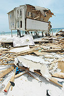
makes landfall on Cayo CostaCayo Costa State ParkCayo Costa State Park is a Florida State Park on La Costa Island, which is directly south of Boca Grande, Florida, west of Cape Coral and just north of Sanibel and Captiva Islands...
with winds of 150 mph (240 km/h) and hours later hits the mainland portion of the state at Punta GordaPunta Gorda, FloridaPunta Gorda is a city in Charlotte County, Florida, United States. According to the U.S. Census Bureau estimates of 2007, the city had a population of 16,762. It is the county seat of Charlotte County and the only incorporated municipality in the county...
, becoming the strongest hurricane to hit the United States since Hurricane AndrewHurricane AndrewHurricane Andrew was the third Category 5 hurricane to make landfall in the United States, after the Labor Day Hurricane of 1935 and Hurricane Camille in 1969. Andrew was the first named storm and only major hurricane of the otherwise inactive 1992 Atlantic hurricane season...
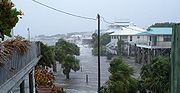
in 1992. The winds damage or destroy thousands of homes, knock down tens of thousands of trees, and leave more than 2 million Floridians without power. Charley results in eight direct fatalities, 20 indirect casualties, and 792 reported injuries. Throughout the state, damage is estimated at $13.5 billion (2004 USD, $15.4 billion 2008 USD), at the time the second costliest hurricane in United States history; it has since dropped to fifth. - September 5, 2004 – Hurricane FrancesHurricane FrancesHurricane Frances was the sixth named storm, the fourth hurricane, and the third major hurricane of the 2004 Atlantic hurricane season. The system crossing the open Atlantic during mid to late August, moving to the north of the Lesser Antilles while strengthening. Its outer bands affected Puerto...
strikes the southern end of Hutchinson IslandHutchinson Island South, FloridaHutchinson Island South is a census-designated place on the barrier island of Hutchinson Island in St. Lucie County, Florida, United States. The South in its name refers to its location in the southern part of St. Lucie County. It is actually in the central or middle part of the island as a...
as a slow-moving Category 2 hurricaneSaffir-Simpson Hurricane ScaleThe Saffir–Simpson Hurricane Scale , or the Saffir–Simpson Hurricane Wind Scale , classifies hurricanes — Western Hemisphere tropical cyclones that exceed the intensities of tropical depressions and tropical storms — into five categories distinguished by the intensities of their sustained winds...
, producing heavy rainfall peaking at 15.84 inches (402 mm) at High SpringsHigh Springs, FloridaHigh Springs is a city in Alachua County, Florida, United States. The population was 3,863 at the 2000 census. As of 2004, the population recorded by the U.S. Census Bureau is 4,139 .-Geography:High Springs is located at ....
. The hurricane damages 15,000 homes and 2,400 businesses in Palm Beach CountyPalm Beach County, FloridaPalm Beach County is the largest county in the state of Florida in total area, and third in population. As of 2010, the county's estimated population was 1,320,134, making it the twenty-eighth most populous in the United States...
alone, with damage across the state totaling $8.32 billion (2004 USD, $9.5 billion 2008 USD). Hurricane Frances kills five people directly in the state and is indirectly responsible for 32 deaths. - September 16, 2004 – Hurricane IvanHurricane IvanHurricane Ivan was a large, long-lived, Cape Verde-type hurricane that caused widespread damage in the Caribbean and United States. The cyclone was the ninth named storm, the sixth hurricane and the fourth major hurricane of the active 2004 Atlantic hurricane season...
strikes Orange Beach, AlabamaOrange Beach, AlabamaOrange Beach is a city in Baldwin County, Alabama, United States. At the 2000 census the population was 3,784. It is part of the Daphne–Fairhope–Foley Micropolitan Statistical Area.-Geography:...
as a major hurricane, with its large and powerful circulation producing peak wind gusts of 107 mph (173 km/h) in PensacolaPensacola, FloridaPensacola is the westernmost city in the Florida Panhandle and the county seat of Escambia County, Florida, United States of America. As of the 2000 census, the city had a total population of 56,255 and as of 2009, the estimated population was 53,752...
. The winds down more than 125,000 ft³ (3,540 m³) at a forest near Pensacola, while strong waves and a 10–15 foot (3—4.5 m) storm surge severely damages the Interstate 10Interstate 10 in FloridaThe of Interstate 10 in Florida is the eastern most section of the east–west Interstate 10 in the Southern United States. It is also the eastern end of the Interstate Highway known as the Christopher Columbus Transcontinental Highway, one of three coast to coast interstates, along with I-80...
bridge in Pensacola. Throughout the state damage totals $8 billion (2004 USD, $9.1 billion 2008 USD), and 14 people die in the state from the hurricane. The remnants of Ivan later cross over the southern portion of the state on September 21 after looping southward, and ultimately reform in the Gulf of MexicoGulf of MexicoThe Gulf of Mexico is a partially landlocked ocean basin largely surrounded by the North American continent and the island of Cuba. It is bounded on the northeast, north and northwest by the Gulf Coast of the United States, on the southwest and south by Mexico, and on the southeast by Cuba. In...
on September 23. - September 26, 2004 – Hurricane JeanneHurricane JeanneHurricane Jeanne was the deadliest hurricane in the 2004 Atlantic hurricane season. It was the tenth named storm, the seventh hurricane, and the fifth major hurricane of the season, as well as the third hurricane and fourth named storm of the season to make landfall in Florida...
hits the southern portion of the state very near where Frances struck three weeks prior, producing moderate winds and rainfall reaching 11.97 inches (304 mm) at KenansvilleKenansville, FloridaKenansville, Florida, USA, is an unincorporated community with a population of just under 1000, a large number of which are over the age of 50, located at the junction of Osceola County Road 523 and U.S. Highway 441 in Osceola County, Florida, just 12 miles north of Yeehaw Junction and 27 miles...
. Jeanne produces hurricane force winds across an area previously affected by one or two other hurricanes, causing about $3.5 billion in damage (2004 USD, $4 billion 2008 USD). The passage of Hurricane Jeanne results in three deaths; two due to winds and one from flooding. - October 10, 2004 – Tropical Storm MatthewTropical Storm Matthew (2004)Tropical Storm Matthew was a weak tropical storm in the 2004 Atlantic hurricane season that made landfall on Louisiana. Matthew was the thirteenth tropical storm of the season and the ninth storm to affect the United States. Matthew formed over the western Gulf of Mexico on October 8 and struck...
hits southern LouisianaLouisianaLouisiana is a state located in the southern region of the United States of America. Its capital is Baton Rouge and largest city is New Orleans. Louisiana is the only state in the U.S. with political subdivisions termed parishes, which are local governments equivalent to counties...
, with its outer rainbandRainbandA rainband is a cloud and precipitation structure associated with an area of rainfall which is significantly elongated. Rainbands can be stratiform or convective, and are generated by differences in temperature. When noted on weather radar imagery, this precipitation elongation is referred to as...
s producing light rainfall across the western portion of Florida.
2005
- June 11, 2005 – Tropical Storm ArleneTropical Storm Arlene (2005)Tropical Storm Arlene was an unusually large and early-forming tropical storm forming during the 2005 Atlantic hurricane season. It was the first storm of the season, which would become the most active on record. Tropical Storm Arlene formed near Honduras on June 8 and moved northwards...
strikes just west of PensacolaPensacola, FloridaPensacola is the westernmost city in the Florida Panhandle and the county seat of Escambia County, Florida, United States of America. As of the 2000 census, the city had a total population of 56,255 and as of 2009, the estimated population was 53,752...
, bringing moderate precipitation throughout the state and causing breaches on barrier islands on the Florida PanhandleFlorida PanhandleThe Florida Panhandle, an informal, unofficial term for the northwestern part of Florida, is a strip of land roughly 200 miles long and 50 to 100 miles wide , lying between Alabama on the north and the west, Georgia also on the north, and the Gulf of Mexico to the south. Its eastern boundary is...
. Damage totals over $3.5 million (2005 USD, $4 million 2008 USD), and one person dies in Miami BeachMiami Beach, FloridaMiami Beach is a coastal resort city in Miami-Dade County, Florida, United States, incorporated on March 26, 1915. The municipality is located on a barrier island between the Atlantic Ocean and Biscayne Bay, the latter which separates the Beach from Miami city proper...
from rip currents caused by the storm. - July 6, 2005 – Hurricane CindyHurricane Cindy (2005)Hurricane Cindy was a tropical cyclone that briefly reached minimal hurricane strength in the Gulf of Mexico during July in the 2005 Atlantic hurricane season and made landfall in Louisiana. It was the third named storm and first hurricane of the season...
hits south-central LouisianaLouisianaLouisiana is a state located in the southern region of the United States of America. Its capital is Baton Rouge and largest city is New Orleans. Louisiana is the only state in the U.S. with political subdivisions termed parishes, which are local governments equivalent to counties...
, with its large circulation resulting in moderate beach erosion and fallen trees along the western Florida PanhandleFlorida PanhandleThe Florida Panhandle, an informal, unofficial term for the northwestern part of Florida, is a strip of land roughly 200 miles long and 50 to 100 miles wide , lying between Alabama on the north and the west, Georgia also on the north, and the Gulf of Mexico to the south. Its eastern boundary is...
; damage is minor. - July 10, 2005 – Hurricane DennisHurricane DennisHurricane Dennis was an early-forming major hurricane in the Caribbean and Gulf of Mexico during the very active 2005 Atlantic hurricane season. Dennis was the fourth named storm, second hurricane, and first major hurricane of the season...
makes landfall just west of Navarre BeachNavarre Beach, FloridaNavarre Beach, is an unincorporated community in Santa Rosa County in the U.S. state of Florida. It is on Santa Rosa Island, a barrier island in the Gulf of Mexico. The community is considered part of the Pensacola–Ferry Pass–Brent Metropolitan Statistical Area.Immediately to its east...
as a major hurricane, producing moderate rainfall and 9 tornadoes throughout the state. 2 people drown in the Gulf of MexicoGulf of MexicoThe Gulf of Mexico is a partially landlocked ocean basin largely surrounded by the North American continent and the island of Cuba. It is bounded on the northeast, north and northwest by the Gulf Coast of the United States, on the southwest and south by Mexico, and on the southeast by Cuba. In...
, and the hurricane was indirectly responsible for twelve other fatalities. Damage in the state totals about $1.5 billion (2005 USD, $1.65 billion 2008 USD). - August 25, 2005 – Hurricane KatrinaHurricane KatrinaHurricane Katrina of the 2005 Atlantic hurricane season was a powerful Atlantic hurricane. It is the costliest natural disaster, as well as one of the five deadliest hurricanes, in the history of the United States. Among recorded Atlantic hurricanes, it was the sixth strongest overall...
makes landfall near the BrowardBroward County, Florida-2000 Census:As of the census of 2000, there were 1,623,018 people, 654,445 households, and 411,645 families residing in the county. The population density was 1,346 people per square mile . There were 741,043 housing units at an average density of 615 per square mile...
/Miami-Dade CountyMiami-Dade County, FloridaMiami-Dade County is a county located in the southeastern part of the state of Florida. As of 2010 U.S. Census, the county had a population of 2,496,435, making it the most populous county in Florida and the eighth-most populous county in the United States...
border, producing gusty winds and heavy rainfall peaking at 16.33 inches (415 mm) in PerrinePerrine, FloridaPerrine, Florida was an unincorporated community in Miami-Dade County about midway between Miami and Homestead. It is located at The community was named after Dr...
. Damage amounts to $523 million (2005 USD, $577 million 2008 USD) in the southern portion of the state, and twelve people die in southern Florida; three from drowning, three from falling trees, and six from indirect causes. Minor damage is reported along the Florida PanhandleFlorida PanhandleThe Florida Panhandle, an informal, unofficial term for the northwestern part of Florida, is a strip of land roughly 200 miles long and 50 to 100 miles wide , lying between Alabama on the north and the west, Georgia also on the north, and the Gulf of Mexico to the south. Its eastern boundary is...
from its landfall in MississippiMississippiMississippi is a U.S. state located in the Southern United States. Jackson is the state capital and largest city. The name of the state derives from the Mississippi River, which flows along its western boundary, whose name comes from the Ojibwe word misi-ziibi...
. Katrina was only a Category 1 at the time, only to become a monstrous Category 5 days later and wreak havoc along the Gulf Coast. - September 12, 2005 – High surf from Hurricane OpheliaHurricane Ophelia (2005)Hurricane Ophelia was the fifteenth named tropical cyclone and the eighth hurricane of the 2005 Atlantic hurricane season. It was a long-lived storm that was most remembered for its very erratic and extremely slow track off the East Coast of the United States, alternating several times between...
kills a surfer in Palm Beach CountyPalm Beach County, FloridaPalm Beach County is the largest county in the state of Florida in total area, and third in population. As of 2010, the county's estimated population was 1,320,134, making it the twenty-eighth most populous in the United States...
. - September 20, 2005 – Hurricane RitaHurricane RitaHurricane Rita was the fourth-most intense Atlantic hurricane ever recorded and the most intense tropical cyclone ever observed in the Gulf of Mexico. Rita caused $11.3 billion in damage on the U.S. Gulf Coast in September 2005...
passes south of the Florida KeysFlorida KeysThe Florida Keys are a coral archipelago in southeast United States. They begin at the southeastern tip of the Florida peninsula, about south of Miami, and extend in a gentle arc south-southwest and then westward to Key West, the westernmost of the inhabited islands, and on to the uninhabited Dry...
, producing a 5 foot (1.5 m) storm surge which affects up to 200 residencies and severely injures a bicyclist. - October 5, 2005 – Tropical Storm TammyTropical Storm Tammy (2005)Tropical Storm Tammy was a short lived tropical storm during October in the 2005 Atlantic hurricane season which caused minor damage to the southeastern United States. More significant, however were its remnants which contributed to the Northeast U.S. flooding of October 2005.Tropical Storm Tammy...
hits near Atlantic BeachAtlantic Beach, FloridaAtlantic Beach, a city in Duval County, Florida, is the northernmost of the Jacksonville Beaches communities. When the majority of communities in Duval County consolidated with Jacksonville, Florida in 1968, Atlantic Beach, along with Jacksonville Beach, Neptune Beach, and Baldwin, Florida,...
, resulting in moderate rainfall and light damage. - October 24, 2005 – Hurricane WilmaHurricane WilmaHurricane Wilma was the most intense tropical cyclone ever recorded in the Atlantic basin. Wilma was the twenty-second storm , thirteenth hurricane, sixth major hurricane, and fourth Category 5 hurricane of the record-breaking 2005 season...
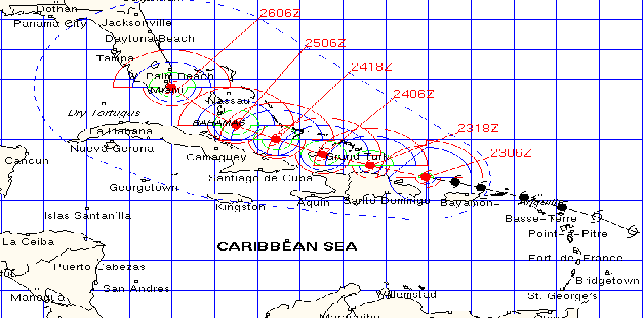
makes landfall near Cape Romano as a major hurricane, producing hurricane force winds and moderate precipitation across much of southern portion of the state. The winds of the hurricane leave 98% of South Florida without power. The passage of Wilma results in hundreds of damaged or destroyed homes, with damage reaching $20.6 billion (2005 USD, $22.7 billion 2008 USD), the fourth costliest tropical cyclone in United States history. Five people die in the state as a result of the hurricane.
2006
- June 13, 2006 – Tropical Storm AlbertoTropical Storm Alberto (2006)Tropical Storm Alberto was the first tropical storm of the 2006 Atlantic hurricane season. Forming on June 10 in the northwestern Caribbean, the storm moved generally to the north, reaching a maximum intensity of 70 mph before weakening and moving ashore in the Big Bend area of Florida on...
hits near Adams Beach, producing 4.51 inches (115 mm) of rainfall in SarasotaSarasota, FloridaSarasota is a city located in Sarasota County on the southwestern coast of the U.S. state of Florida. It is south of the Tampa Bay Area and north of Fort Myers...
and a storm tideStorm tideA storm tide is a tide with a high flood period caused by a storm. Storm tides can be a severe danger to the coast and the people living along the coast. The water level can rise to more than 5 meters above the normal tide....
unofficially reaching 9 feet (2.7 m) in Dixie CountyDixie County, FloridaDixie County is a county located in the U.S. state of Florida. As of 2000, the population was 13,827. The U.S. Census Bureau 2005 estimate for the county is 14,647 . Its county seat is Cross City, Florida.- History :...
. The passage of Alberto causes flood damage to dozens of homes. - August 30, 2006 – Tropical Storm ErnestoHurricane Ernesto (2006)Hurricane Ernesto was the costliest tropical cyclone of the 2006 Atlantic hurricane season. The sixth tropical storm and first hurricane of the season, Ernesto developed from a tropical wave on August 24 in the eastern Caribbean Sea...
strikes Plantation KeyPlantation Key, FloridaPlantation Key, Florida is a former census-designated place on Plantation Key in the Florida Keys, in Monroe County, Florida, United States. It was reported to have a population of 4,405 in 1990. It became part of the Village of Islamorada when the latter incorporated in 1997.-External links:*...
and a short while later on the southwest Florida coastline. The storm spawns two tornadoes in the state, while moderate rainfall peaking at 8.72 inches (221 mm) in South Golden GateGolden Gate, FloridaGolden Gate is a community and census-designated place in Collier County, Florida, United States. The population was 20,951 as recorded in the 2000 census...
floods 13 houses in PalmdalePalmdale, FloridaPalmdale is an unincorporated community in Glades County, Florida, United States. It is located on US 27/State Road 25/State Road 29, just north of where US 27 and SR 29 split off from SR 25...
.
2007
- May 9, 2007 – Subtropical Storm AndreaSubtropical Storm Andrea (2007)Subtropical Storm Andrea was the first named storm and first subtropical cyclone of the 2007 Atlantic hurricane season. It developed out of a previously non-tropical low on May 9 about 150 miles northeast of Daytona Beach, Florida, three weeks before the official start of the season...
forms to the northeast of the state, and produces strong waves that cause severe beach erosion in some locations. - June 2, 2007 – Tropical Storm BarryTropical Storm Barry (2007)Tropical Storm Barry was a rapidly-forming tropical cyclone that made landfall on Florida, United States, in early June 2007. The second named storm of the 2007 Atlantic hurricane season, Barry developed from a trough of low pressure in the southeastern Gulf of Mexico on June 1...
makes landfall near Tampa BayTampa BayTampa Bay is a large natural harbor and estuary along the Gulf of Mexico on the west central coast of Florida, comprising Hillsborough Bay, Old Tampa Bay, Middle Tampa Bay, and Lower Tampa Bay."Tampa Bay" is not the name of any municipality...
as a disorganized tropical cyclone, and drops moderate precipitation across the drought-ridden state that peaks at 6.99 inches (178 mm) in Palm BeachPalm Beach, FloridaThe Town of Palm Beach is an incorporated town in Palm Beach County, Florida, United States. The Intracoastal Waterway separates it from the neighboring cities of West Palm Beach and Lake Worth...
. The rainfall causes slick roads, leading to two indirect traffic casualties. Damage in the state is minor. - August 23, 2007 – Rip currents from Hurricane DeanHurricane DeanThe name Dean was used for five tropical cyclones in the Northern Atlantic Ocean:*1983's Tropical Storm Dean, which struck the coast of Virginia, causing minor erosion and flooding...
kill one person at Siesta KeySiesta Key, FloridaSiesta Key is a barrier island off the central western coast of Florida in the United States of America. It is situated between Sarasota Bay and the Gulf of Mexico. A portion of it lies within the city boundary of Sarasota, but the majority of the key is a census-designated place in Sarasota County...
. - September 13, 2007 – The remnants of Hurricane HumbertoHurricane Humberto (2007)Hurricane Humberto was a minimal hurricane that formed and intensified faster than any other North Atlantic tropical cyclone on record before landfall. Developing on September 12, 2007, in the northwestern Gulf of Mexico, the tropical cyclone rapidly strengthened and struck High Island, Texas, with...
drop light rainfall on the western Florida Panhandle.
- September 22, 2007 – Tropical Depression TenTropical Depression Ten (2007)Tropical Depression Ten was a short-lived tropical cyclone that made landfall on the Florida Panhandle in September 2007. The system developed as a subtropical depression on September 21 in the northeastern Gulf of Mexico from the interaction of a tropical wave, the tail end of a cold front, and an...
moves ashore near Fort Walton BeachFort Walton Beach, FloridaFort Walton Beach is a city in southern Okaloosa County, Florida, United States. As of 2005, the population estimate for Fort Walton Beach was 19,992, and as of 2010, the population estimate for Fort Walton Beach is 19,507 recorded by the U.S. Census Bureau...
and produces light to moderate rainfall, with its precursor system spawning a damaging tornado in EustisEustis, FloridaEustis is a city in Lake County, Florida, United States. The population was 15,106 at the 2000 census. The Census Bureau estimated the population in 2008 to be 19,129. It is part of the Orlando–Kissimmee Metropolitan Statistical Area.-Geography:...
. - October 31, 2007 – The interaction between Tropical Storm Noel and a ridgeRidge (meteorology)A ridge is an elongated region of relatively high atmospheric pressure, the opposite of a trough....
to its north produces strong winds and high waves along the state's eastern coastline. - December 13, 2007 – The remnants of Tropical Storm OlgaTropical Storm Olga (2007)Tropical Storm Olga was the fifteenth named storm of the 2007 Atlantic hurricane season. In the second week of December, after the official end of the hurricane season, a low developed east of the northernmost Lesser Antilles. It slowly acquired tropical characteristics, and late on December 10,...
drop moderate precipitation in the state.
2008
- July 16, 2008 – The precursor to Tropical Storm CristobalTropical Storm Cristobal (2008)Tropical Storm Cristobal was the third named storm of the 2008 Atlantic hurricane season. It formed on July 19 from a trough of low pressure off the Southeast U.S. Coast. In a marginally favorable environment, it attained minimal tropical storm status later that day. The storm remained offshore,...
drops moderate rainfall, causing minor street flooding and little damage. - July 22, 2008 – Rip currents from Hurricane DollyHurricane Dolly (2008)Hurricane Dolly was a tropical cyclone that made landfall in extreme southern Texas in July 2008. Dolly was the fourth tropical cyclone and second hurricane to form during the 2008 Atlantic hurricane season. It was the first U.S. landfalling hurricane of the 2008 season. Dolly developed on July 20...
kill one person and injures four at beaches along the panhandle. - August 18–23, 2008 – Tropical Storm FayTropical Storm Fay (2008)Tropical Storm Fay was a tropical storm and the sixth named storm of the 2008 Atlantic hurricane season. Fay formed from a vigorous tropical wave on August 15 over the Dominican Republic...
made a record four landfalls in Florida. Extreme flooding was reported in many counties in central FloridaCentral FloridaCentral Florida is a regional designation for the area surrounding Orlando in east central Florida, United States. The area represents the third largest population concentration in Florida, after the South Florida and Tampa Bay regions, respectively....
and the Florida panhandleFlorida PanhandleThe Florida Panhandle, an informal, unofficial term for the northwestern part of Florida, is a strip of land roughly 200 miles long and 50 to 100 miles wide , lying between Alabama on the north and the west, Georgia also on the north, and the Gulf of Mexico to the south. Its eastern boundary is...
. According to the National Hurricane CenterNational Hurricane CenterThe National Hurricane Center , located at Florida International University in Miami, Florida, is the division of the National Weather Service responsible for tracking and predicting weather systems within the tropics between the Prime Meridian and the 140th meridian west poleward to the 30th...
's Tropical Cyclone Report on Fay, five people were killed throughout the state. - August 31–September 1 – Hurricane GustavHurricane GustavThe name Gustav has been used for five tropical cyclones in the Atlantic Ocean:* 1984's Tropical Storm Gustav - Spent most of its existence as a tropical depression hovering over Bermuda, no major damage was reported....
brushed the Florida Keys before tracking into central Louisiana, producing six tornadoes, heavy rain up to 4.12 in (104.6 mm), and strong rip currents throughout the state. The outer rain bands produced three waterspouts in the Panhandle, each coming ashore near ValparaisoValparaiso, FloridaValparaiso is a city in Okaloosa County, Florida, in the United States, and it is named after the Chilean city of Valparaiso. As of the 2000 census, the city population was 6,408. According to the U.S. Census Bureau's 2004 estimates, the city had a population of 6,336...
. Four people drowned as a result of the rip currents in southern Florida. - September 2, 2008 – Rip currents from Tropical Storm HannaHurricane Hanna (2008)Hurricane Hanna was the deadliest storm of the 2008 Atlantic hurricane season. The storm was the eighth tropical cyclone and fourth hurricane of the 2008 Atlantic hurricane season. It formed east-northeast of the northern Leeward Islands on August 28...
are reported along the Southeast U.S. Coast. A 14-year-old boy drowned at John U. Lloyd Beach State ParkJohn U. Lloyd Beach State ParkJohn U. Lloyd Beach State Park is a Florida State Park located in Hollywood, Florida off A1A. The park's namesake served as Broward County Attorney for over 30 years and was instrumental in obtaining the land for the park....
near Hollywood, FloridaHollywood, Florida-Demographics:As of 2000, there were 59,673 households out of which 24.9% had children under the age of 18 living with them, 41.5% were married couples living together, 11.9% had a female householder with no husband present, and 42.2% were non-families. 34.4% of all households were made up of...
as a result of the rip currents brought up by the distant Hanna. Two more deaths were reported off the coast of Fort Lauderdale, FloridaFort Lauderdale, FloridaFort Lauderdale is a city in the U.S. state of Florida, on the Atlantic coast. It is the county seat of Broward County. As of the 2010 census, the city had a population of 165,521. It is a principal city of the South Florida metropolitan area, which was home to 5,564,635 people at the 2010...
as they drowned in the high seas.
2009
- August 16–18, 2009 – Tropical Storm ClaudetteTropical Storm Claudette (2009)Tropical Storm Claudette was the third named storm of the 2009 Atlantic hurricane season and the first tropical cyclone of 2009 to affect the United States. Forming out of a tropical wave and an upper-level low pressure system on August 16, Claudette quickly intensified into a tropical storm...
hits Santa Rosa IslandSanta Rosa Island, FloridaSanta Rosa Island[p] is a 40-mile barrier island located in the U.S. state of Florida, thirty miles east of the Alabama state border...
, killing two people. An EF-0 tornadoEnhanced Fujita ScaleThe Enhanced Fujita Scale rates the strength of tornadoes in the United States based on the damage they cause.Implemented in place of the Fujita scale introduced in 1971 by Ted Fujita, it began operational use on February 1, 2007. The scale has the same basic design as the original Fujita scale:...
spawned by the storm in Cape Coral, Florida damaged 11 homes, leaving $103,000 in damage. - August 21–22, 2009 – Hurricane BillHurricane Bill (2009)Hurricane Bill was a relatively large Atlantic tropical cyclone, attaining a maximum gale-diameter of 460 mi . A Cape Verde type hurricane, Bill originated from a tropical wave that emerged from the western coast of Africa on August 12, and organized into a tropical depression near the Cape...
produced waves between 5 foot along the east coast of Florida, resulting in one fatality at New Smyrna BeachNew Smyrna Beach, FloridaNew Smyrna Beach is a city in Volusia County, Florida, United States. The population was 20,048 according to the 2000 census. As of 2007, the population recorded by the U.S. Census Bureau is 23,161.-History:...
. - November 9–11, 2009 – The extratropical remnantsExtratropical cycloneExtratropical cyclones, sometimes called mid-latitude cyclones or wave cyclones, are a group of cyclones defined as synoptic scale low pressure weather systems that occur in the middle latitudes of the Earth having neither tropical nor polar characteristics, and are connected with fronts and...
of Hurricane IdaHurricane Ida (2009)Hurricane Ida was the strongest landfalling tropical cyclone during the 2009 Atlantic hurricane season, crossing the coastline of Nicaragua with winds of 80 mph . The remnants of the storm became a powerful nor'easter that caused widespread damage along coastal areas of the Mid-Atlantic States...
brings rainfall, strong waves and power outages to the panhandle, leaving roughly $250,000 in losses.
2010
- June 30, 2010 – Tropical Storm Alex passes through the area affected by the Deepwater Horizon oil spillDeepwater Horizon oil spillThe Deepwater Horizon oil spill is an oil spill in the Gulf of Mexico which flowed unabated for three months in 2010, and continues to leak fresh oil. It is the largest accidental marine oil spill in the history of the petroleum industry...
, causing tarballTarball (oil)A tarball is a blob of petroleum which has been weathered after floating in the ocean. Tarballs are an aquatic pollutant in most environments, although they can occur naturally and as such are not always associated with oil spills....
s from the spill as large as apples to wash onshore portions of the panhandle from high storm tideStorm tideA storm tide is a tide with a high flood period caused by a storm. Storm tides can be a severe danger to the coast and the people living along the coast. The water level can rise to more than 5 meters above the normal tide....
s created by the storm. - July 23, 2010 – Tropical Storm Bonnie makes landfall near Cutler Bay, FloridaCutler Bay, FloridaCutler Bay, historically called Cutler Ridge, is an incorporated town in Miami-Dade County, Florida from SW 184th Street east of US-1 to the coast, and north of Black Point Marina, at...
as a minimal tropical storm, bringing light rainfall and winds to southern parts of the state. - August 10, 2010 – Tropical Depression FiveTropical Depression Five (2010)Tropical Depression Five was an Atlantic tropical cyclone that lasted less than 36 hours, although its remnants persisted for almost another week. The fifth depression of the 2010 Atlantic hurricane season, its precursor was from a non-tropical trough east of Florida, and on August 10 it...
develops off the southwest coast, producing high surf that indirectly causes two drowning deaths along Anna Maria IslandAnna Maria IslandAnna Maria Island, sometimes called Anna Maria Key, is a barrier island on the coast of Manatee County, Florida in the United States. It is bounded on the west by the Gulf of Mexico, on the south by Longboat Pass , on the east by Anna Maria Sound, and on the north by Tampa Bay. Anna Maria Island...
. - September 2, 2010 – Hurricane EarlHurricane Earl (2010)Hurricane Earl was a long-lived, powerful tropical cyclone which became the first major hurricane to threaten New England since Hurricane Bob in 1991. The fifth named storm of the 2010 season, Earl developed out of a tropical wave roughly west of the Cape Verde Islands on August 25...
passes a couple of hundred miles offshore as a category four, bringing deadly rip currents and rough surf to the coastline, drowning one surfer in New Symrna Beach. - September 29, 2010 – Tropical Storm NicoleTropical Storm Nicole (2010)Tropical Storm Nicole was a short-lived and asymmetric tropical cyclone that caused extensive damage in Jamaica during the 2010 Atlantic hurricane season. It was the sixteenth tropical cyclone and fourteenth named storm of the season, as well as the last of a record eight tropical storms to form in...
dissipates just as it bears down on the coastline, bringing a very brief period of heavy rainfall amounting up to 2 inches (50.8 mm).
2011
- July 17, 2011 – Tropical Storm BretTropical Storm Bret (2011)Tropical Storm Bret was the second named storm of the 2011 Atlantic hurricane season. It developed along the southwestern periphery of a weather front to the north of the Bahamas on July 17. At first, Bret moved little and gradually strengthened in response to favorable upper-level conditions,...
forms just off the East Coast, generating rough surf up to 7 feet (2.1 m) offshore as well as several rescues and minor injuries. Several waterspouts are also reported near the coast. - August 25-26, 2011 – Hurricane IreneHurricane Irene (2011)Hurricane Irene was a large and powerful Atlantic hurricane that left extensive flood and wind damage along its path through the Caribbean, the United States East Coast and as far north as Atlantic Canada in 2011...
passes about 150–200 mi (241.4–321.9 km) to the east as a major hurricane generating rough surf up to 12 feet (3.7 m) offshore which kills two people off the East Coast injuring several others, on-and-off rainfall of up to 3 inches (76.2 mm) from its large circulation and gusts of up to 40 mph (65 km/h) which cause very minor wind damage and isolated power outages near the coast. - September 3-5, 2011 – Tropical Storm LeeTropical Storm Lee (2011)Tropical Storm Lee was the twelfth named storm and thirteenth system overall of the 2011 Atlantic hurricane season, developing from a broad tropical disturbance over the Gulf on September 1. It was designated as Tropical Storm Lee the next day...
makes landfall in Central Louisiana and rides east through Mississippi, Alabama and Georgia with its large circulation dumping up to 7 inches (177.8 mm) of rainfall causing flash flooding, winds gusting up to 50 mph (75 km/h) and a few weak tornadoes as well in northwestern Florida. Some light damage such as downed tree limbs and scattered power outages were also reported. Rough surf was reported along much of the Gulf Coast from Pensacola to Fort Myers as well as a large chunk of the East Coast from Jacksonville down to the Vero Beach area.
Monthly statistics
| Month | Number of recorded storms affecting Florida |
|---|---|
| April | 1 |
| May | 1 |
| June | 6 |
| July | 8 |
| August | 15 |
| September | 17 |
| October | 7 |
| November | 2 |
| December | 1 |
Deadly storms
The following is a list of hurricanes with known deaths in the state.| Name | Year | Number of deaths |
|---|---|---|
| Ivan Hurricane Ivan Hurricane Ivan was a large, long-lived, Cape Verde-type hurricane that caused widespread damage in the Caribbean and United States. The cyclone was the ninth named storm, the sixth hurricane and the fourth major hurricane of the active 2004 Atlantic hurricane season... |
2004 | 14 |
| Charley Hurricane Charley Hurricane Charley was the third named storm, the second hurricane, and the second major hurricane of the 2004 Atlantic hurricane season. Charley lasted from August 9 to August 15, and at its peak intensity it attained 150 mph winds, making it a strong Category 4 hurricane on the... |
2004 | 8 (20 indirect) |
| Allison Tropical Storm Allison Tropical Storm Allison was a tropical storm that devastated southeast Texas in June of the 2001 Atlantic hurricane season. The first storm of the season, Allison lasted an unusually long period of time for a June storm, remaining tropical or subtropical for 15 days... |
2001 | 8 |
| Katrina Hurricane Katrina Hurricane Katrina of the 2005 Atlantic hurricane season was a powerful Atlantic hurricane. It is the costliest natural disaster, as well as one of the five deadliest hurricanes, in the history of the United States. Among recorded Atlantic hurricanes, it was the sixth strongest overall... |
2005 | 6 (6 indirect) |
| Frances Hurricane Frances Hurricane Frances was the sixth named storm, the fourth hurricane, and the third major hurricane of the 2004 Atlantic hurricane season. The system crossing the open Atlantic during mid to late August, moving to the north of the Lesser Antilles while strengthening. Its outer bands affected Puerto... |
2004 | 5 (32 indirect) |
| Wilma Hurricane Wilma Hurricane Wilma was the most intense tropical cyclone ever recorded in the Atlantic basin. Wilma was the twenty-second storm , thirteenth hurricane, sixth major hurricane, and fourth Category 5 hurricane of the record-breaking 2005 season... |
2005 | 5 |
| Gustav Hurricane Gustav The name Gustav has been used for five tropical cyclones in the Atlantic Ocean:* 1984's Tropical Storm Gustav - Spent most of its existence as a tropical depression hovering over Bermuda, no major damage was reported.... |
2008 | 4 |
| Hanna Tropical Storm Hanna (2002) Tropical Storm Hanna was a moderately strong tropical storm that affected the Gulf Coast and Southeastern regions of the United States. The tenth tropical cyclone and ninth named storm of the 2002 Atlantic hurricane season, Hanna formed through the complex interaction of a surface trough, a... |
2002 | 3 |
| Jeanne Hurricane Jeanne Hurricane Jeanne was the deadliest hurricane in the 2004 Atlantic hurricane season. It was the tenth named storm, the seventh hurricane, and the fifth major hurricane of the season, as well as the third hurricane and fourth named storm of the season to make landfall in Florida... |
2004 | 3 |
| Dennis Hurricane Dennis Hurricane Dennis was an early-forming major hurricane in the Caribbean and Gulf of Mexico during the very active 2005 Atlantic hurricane season. Dennis was the fourth named storm, second hurricane, and first major hurricane of the season... |
2005 | 2 (12 indirect) |
| Barry Tropical Storm Barry (2001) Tropical Storm Barry was a strong tropical storm that made landfall on the Florida Panhandle during August 2001. The third tropical cyclone and second named storm of the 2001 Atlantic hurricane season, Barry developed from a tropical wave that moved off the coast of Africa on July 24 and tracked... |
2001 | 2 |
| Ana Tropical Storm Ana (2003) Tropical Storm Ana was the only tropical cyclone on record in the Atlantic basin to form during the month of April. The first tropical cyclone of the season, it developed as a subtropical cyclone from a non-tropical low on April 20 to the west of Bermuda... |
2003 | 2 |
| Bill Tropical Storm Bill (2003) Tropical Storm Bill was a tropical storm that affected the Gulf Coast of the United States in the summer of 2003. The second storm of the 2003 Atlantic hurricane season, Bill developed from a tropical wave on June 29 to the north of the Yucatán Peninsula... |
2003 | 2 |
| Claudette Tropical Storm Claudette (2009) Tropical Storm Claudette was the third named storm of the 2009 Atlantic hurricane season and the first tropical cyclone of 2009 to affect the United States. Forming out of a tropical wave and an upper-level low pressure system on August 16, Claudette quickly intensified into a tropical storm... |
2009 | 2 |
| Fay Tropical Storm Fay (2008) Tropical Storm Fay was a tropical storm and the sixth named storm of the 2008 Atlantic hurricane season. Fay formed from a vigorous tropical wave on August 15 over the Dominican Republic... |
2008 | 1 (8 indirect) |
| Barry Tropical Storm Barry (2007) Tropical Storm Barry was a rapidly-forming tropical cyclone that made landfall on Florida, United States, in early June 2007. The second named storm of the 2007 Atlantic hurricane season, Barry developed from a trough of low pressure in the southeastern Gulf of Mexico on June 1... |
2007 | 1 (2 indirect) |
| Gabrielle Hurricane Gabrielle (2001) Hurricane Gabrielle was a moderate category 1 hurricane which made landfall near Venice, Florida as a strong tropical storm. The eighth tropical cyclone, seventh named storm, and third hurricane of the 2001 Atlantic hurricane season, Gabrielle developed from a non-tropical low-to mid-level trough... |
2001 | 1 (1 indirect) |
| Gordon Hurricane Gordon (2000) Hurricane Gordon was one of two U.S. landfalling tropical storms of the 2000 Atlantic hurricane season, and was the 7th named storm and 4th hurricane of the 2000 Atlantic hurricane season. Gordon was a category 1 hurricane over the Gulf of Mexico but weakened to a tropical storm before making... |
2000 | 1 |
| Bertha Tropical Storm Bertha (2002) Tropical Storm Bertha was a minimal tropical storm that made landfall twice along the Gulf Coast of the United States in August 2002. The second tropical storm of the 2002 Atlantic hurricane season, Bertha developed in the northern Gulf of Mexico out of a trough of low pressure that extended into... |
2002 | 1 |
| Isabel Hurricane Isabel Hurricane Isabel was the costliest and deadliest hurricane in the 2003 Atlantic hurricane season. The ninth named storm, fifth hurricane, and second major hurricane of the season, Isabel formed near the Cape Verde Islands from a tropical wave on September 6 in the tropical Atlantic Ocean... |
2003 | 1 |
| Arlene Tropical Storm Arlene (2005) Tropical Storm Arlene was an unusually large and early-forming tropical storm forming during the 2005 Atlantic hurricane season. It was the first storm of the season, which would become the most active on record. Tropical Storm Arlene formed near Honduras on June 8 and moved northwards... |
2005 | 1 |
| Ophelia Hurricane Ophelia (2005) Hurricane Ophelia was the fifteenth named tropical cyclone and the eighth hurricane of the 2005 Atlantic hurricane season. It was a long-lived storm that was most remembered for its very erratic and extremely slow track off the East Coast of the United States, alternating several times between... |
2005 | 1 |
| Dean Hurricane Dean The name Dean was used for five tropical cyclones in the Northern Atlantic Ocean:*1983's Tropical Storm Dean, which struck the coast of Virginia, causing minor erosion and flooding... |
2007 | 1 |
| Dolly Hurricane Dolly (2008) Hurricane Dolly was a tropical cyclone that made landfall in extreme southern Texas in July 2008. Dolly was the fourth tropical cyclone and second hurricane to form during the 2008 Atlantic hurricane season. It was the first U.S. landfalling hurricane of the 2008 season. Dolly developed on July 20... |
2008 | 1 |
| Bill Hurricane Bill (2009) Hurricane Bill was a relatively large Atlantic tropical cyclone, attaining a maximum gale-diameter of 460 mi . A Cape Verde type hurricane, Bill originated from a tropical wave that emerged from the western coast of Africa on August 12, and organized into a tropical depression near the Cape... |
2009 | 1 |
| Irene Hurricane Irene (2011) Hurricane Irene was a large and powerful Atlantic hurricane that left extensive flood and wind damage along its path through the Caribbean, the United States East Coast and as far north as Atlantic Canada in 2011... |
2011 | 1 |
| Leslie Tropical Storm Leslie (2000) Tropical Storm Leslie was a weak, short-lived tropical cyclone that was never well-organized; however, its precursor was costlier than any other tropical cyclone in the 2000 Atlantic hurricane season. The twelfth named storm of the season, Leslie formed on October 4 over eastern Florida as a... |
2000 | 0 (3 indirect) |
| Hanna Hurricane Hanna (2008) Hurricane Hanna was the deadliest storm of the 2008 Atlantic hurricane season. The storm was the eighth tropical cyclone and fourth hurricane of the 2008 Atlantic hurricane season. It formed east-northeast of the northern Leeward Islands on August 28... |
2008 | 0 (3 indirect) |
| TD Five Tropical Depression Five (2010) Tropical Depression Five was an Atlantic tropical cyclone that lasted less than 36 hours, although its remnants persisted for almost another week. The fifth depression of the 2010 Atlantic hurricane season, its precursor was from a non-tropical trough east of Florida, and on August 10 it... |
2010 | 0 (2 indirect) |
| Claudette Hurricane Claudette (2003) Hurricane Claudette was the third tropical storm and first hurricane of the 2003 Atlantic hurricane season. A fairly long-lived July Atlantic hurricane, Claudette began as a tropical wave in the eastern Caribbean. It moved quickly westward, brushing past the Yucatán Peninsula before moving... |
2003 | 0 (1 indirect) |