
.gif)
Hurricane Ernesto (2006)
Encyclopedia
Hurricane Ernesto was the costliest tropical cyclone
of the 2006 Atlantic hurricane season. The sixth tropical storm
and first hurricane of the season, Ernesto developed from a tropical wave
on August 24 in the eastern Caribbean Sea
. Ernesto first affected the northern Caribbean
, reaching minimal hurricane status near Haiti
before weakening and moving across eastern Cuba as a tropical storm. Despite initial predictions for it to track through the eastern Gulf of Mexico
as a major hurricane, Ernesto moved across eastern Florida as a weak tropical storm. After turning to the northeast, it re-intensified and made landfall
on August 31 on the North Carolina coast just below hurricane status. Late the next day, Ernesto became extratropical after entering southern Virginia. The remnants spread moisture across the northeastern United States before dissipating over eastern Canada on September 4.
The deaths of at least eleven people were attributed to Ernesto, which dumped heavy rains throughout its path, especially in the Mid-Atlantic region
of the United States. While moving across the Caribbean, it affected several countries, and initially Ernesto posed a threat to the Gulf Coast of the United States
around the one year anniversary of Hurricane Katrina
. Damage in Virginia was estimated at over $118 million (2006 USD, $ USD), prompting the declaration of a federal disaster area. Total damage in the United States
was estimated at $500 million (2006 USD, $ USD).
. It tracked westward, and its convection began organizing and concentrating on August 22. The next day, convection increased along the wave axis, and Dvorak classifications
from the Tropical Analysis and Forecast Branch of the National Hurricane Center
began at 1200 UTC
on August 23. As it approached the Lesser Antilles, a surface low
developed, and with the confirmation of a closed low-level circulation from the Hurricane Hunters
, it is estimated the system developed into Tropical Depression Five on August 24 about 50 mi (80.5 km) north-northwest of Grenada
.
Located to the south of a ridge
across the southwestern Atlantic Ocean
, the depression tracked west-northwestward through an area of dry air and westerly wind shear
. Despite the shear, convection intensified near the center as banding features improved, and on August 24, the depression intensified into Tropical Storm Ernesto. Convection deepened and expanded, though wind shear displaced the low-level center to the west of the convection. By August 26, the structure had become much better-defined, and within five days Ernesto was forecast to be located about 275 mi (445 km) south of the Gulf Coast of the United States as a major hurricane
. The center reformed under the deepest convection after wind shear decreased, and at the same time outflow
increased in all quadrants. Turning northwestward, a small eye
formed, and early on August 27 Ernesto attained hurricane status about 95 mi (152.9 km) south-southwest of the border between Haiti and the Dominican Republic
.
Upon becoming a hurricane, Ernesto was believed to be undergoing rapid intensification
. However, the small inner core deteriorated as the circulation interacted with the mountainous terrain of southwest Haiti, and it quickly weakened back to tropical storm status. The center became broad and ill-defined, though it was forecast to re-intensify to hurricane status before striking Cuba. It continued to weaken due to land interaction, and early on August 28 Ernesto passed just offshore of the southwestern tip of Haiti with winds of 45 mph (72.4 km/h). Hindered by increased wind shear from an upper-level low over the Bahamas, the storm weakened further before striking just west of Guantánamo Bay in Cuba as a minimal tropical storm. With very warm water temperatures and a favorable upper-level environment, one forecast remarked the possibility of Ernesto strengthening greatly over the Straits of Florida
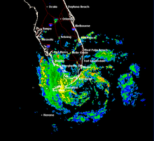
and eastern Gulf of Mexico to hit western Florida as a major hurricane. Ernesto remained over land as a minimal tropical storm for about 18 hours before reaching the Straits of Florida. Convection gradually increased over the warm waters, though Ernesto failed to strengthen significantly due to its disrupted inner core. An eastward-moving high pressure system over the southeastern United States allowed a continued northwest movement, and at 0300 UTC on August 30 the storm struck Plantation Key
in the upper Florida Keys
with winds of 45 mph (72.4 km/h). Two hours later, Ernesto made landfall on the Florida mainland in southwestern Miami-Dade County
.
 Moving through a weakness in the subtropical ridge, the storm turned to the north through the state. Operationally, the National Hurricane Center
downgraded Ernesto to tropical depression status while over the state, though post-analysis indicated the system maintained tropical storm status. Ernesto retained a well-organized cloud pattern over land, and after emerging over the Atlantic Ocean near Cape Canaveral
, convection again increased and began wrapping into the circulation. Upon reaching the Atlantic Ocean, Ernesto accelerated north-northeastward ahead of an approaching deep layer trough
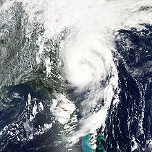
. The convection increased as the storm strengthened over warm waters, and late on August 31 Ernesto attained an intensity of 70 mph (112.7 km/h) while located about 170 mi (273.6 km) south-southwest of Wilmington, North Carolina
. Shortly prior to moving ashore, an eye began to develop, and early on September 1 the storm made landfall on Oak Island
, North Carolina very near the threshold between tropical storm and hurricane status. The National Hurricane Center remarked the possibility that Ernesto could have been a hurricane at landfall, due to the possibility that the strongest maximum wind was not sampled.
 After landfall the storm rapidly weakened, and about eight hours after moving ashore, Ernesto deteriorated to tropical depression status. Interacting with a pre-existing frontal zone
that extended eastward through Virginia
, Ernesto quickly lost its tropical characteristics, and late on September 1 it transitioned into an extratropical cyclone
. It re-intensified to a gale over the Mid-Atlantic states
, only to weaken to an extratropical depression near Pennsylvania
. With a large high pressure area to its east, the remnants turned to the north-northwest, reaching southern Ontario
on September 3. After turning northeastward, the extratropical remnants of Ernesto were absorbed into a larger storm over Quebec
on September 4.
from its border with the Dominican Republic to the southwestern tip of the country. As the storm strengthened, the watch was replaced with a tropical storm warning, and about 15 hours prior to its closest approach the warning was replaced with a hurricane warning. Several low-lying citizens in Gonaïves
were evacuated after local meteorologists anticipated up to 20 inches (500 mm) of rain in some mountainous areas. Additionally, authorities advised residents in shantytowns near the ocean to evacuate to emergency shelters.
Jamaica
n officials issued radio and television advisories for residents in low-lying areas, urging them to be ready and evacuate if necessary. The Jamaican government opened all shelters on the island and placed its armed forces on standby. Long lines for storm supplies were reported at local businesses ahead of the storm as residents rushed to obtain supplies in preparation for Ernesto's onslaught. When a tropical storm warning was put in effect for Jamaica and the central Bahamas, cruise ship companies indicated they were diverting several liners to avoid the storm.
Hurricane warnings were put in effect for six provinces in southeastern Cuba, where significant precipitation ranging up to 20 inches (500 mm) across the mountainous south was expected as the center of Ernesto tracked slowly across Cuba. Cuban officials evacuated 300,000 people and brought its fishing fleet into harbors. The Cuban state television broadcast extensive warnings about the storm, urging precautions. Cattle were moved to higher ground, tourists were evacuated from hotels in the southeastern province of Granma
, and baseball games scheduled for the evening of August 27 in Havana
were played earlier in the day. The threat of the storm caused domestic flights to be canceled.
 On August 26, about four days prior to Ernesto striking the state, the government of Florida activated its Emergency Operations Center, while the National Guard
was placed on standby, following a "warning order" to its commanders. On August 27, the Governor of Florida, Jeb Bush
, issued a state of emergency because of the high risk of impact from Ernesto on the state. Officials issued a mandatory evacuation order for all visitors and non-residents in the Florida Keys about three days before the storm passed through the area. Mandatory evacuations were later issued for mobile homes and low-lying areas of Monroe
, Broward
, St. Lucie
, and Martin
counties; voluntary evacuations were also issued for barrier islands in Miami-Dade and Palm Beach
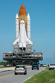
counties. On August 28, forecasters issued a hurricane watch for southern Florida through the Florida Keys. When Ernesto was downgraded to tropical storm status, Governor Jeb Bush urged Florida residents to continue preparations and not wait until it regained hurricane status, as it was forecast to do by the National Hurricane Center. At least 30 shelters were opened, and tolls on four turnpike were lifted. Several schools were closed across southern Florida. The threat of the storm caused NASA
to postpone the launch of Space Shuttle Atlantis
at Kennedy Space Center
to avoid risking damage from the storm.
The storm was initially expected to move into the Gulf of Mexico and affect people recovering from hurricanes Katrina, Rita
, and Wilma
in the previous year, which caused hundreds of billion in damage and left thousands of houses damaged or destroyed. There were initial fears that Ernesto would make landfall days after Hurricane Katrina's one year anniversary, and that the levees in New Orleans
might not be able to withstand a strong storm surge
. Officials in New Orleans prepared buses and trains in the event that people needed to evacuate but could not. A possible path over the Gulf of Mexico oil fields, as well as tension with Iran
, caused the price of oil
to increase, although the prices receded when the threat of the storm receded.
 On August 29, a hurricane watch was issued from the mouth of the Altamaha River
in Georgia
to Cape Fear, North Carolina. The next day, the watch was replaced with a tropical storm warning, which was later extended to Currituck Beach Light
in Corolla, North Carolina
before the storm moved ashore. In South Carolina
, voluntary evacuations occurred in Charleston
and Colleton counties.
On August 31 before the storm's arrival, Virginia Governor Tim Kaine
declared a state of emergency, putting the Virginia National Guard
and state agencies on alert and opening the state's new Emergency Operations Center
in suburban Richmond
. North Carolina Governor Mike Easley
activated 200 National Guard troops and had other emergency teams on standby. Washington D.C. and parts of Maryland
and Delaware
were put on a Coastal Flood Watch and Flash Flood Watch by the National Weather Service
in preparation for Ernesto.
 Shortly before Ernesto developed into a tropical cyclone, the precursor tropical wave produced sustained winds of 37 mph (59.5 km/h) in Barbados
in association with a convective downburst
. On the island, the winds downed some trees, and some flooding was reported. Strong winds and rough seas damaged six fishing boats in the southern portion of the island. Squalls in Trinidad
left about 12 people injured after winds destroyed several tents. Also on Trinidad, the system produced widespread flooding, which resulted in some crop damage.
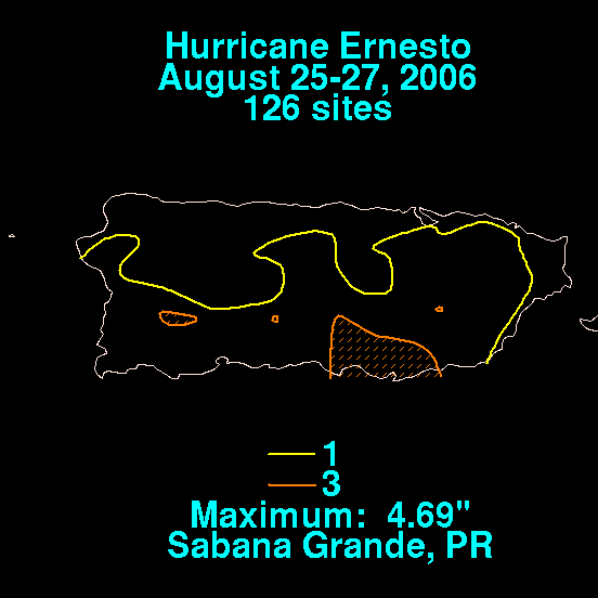
Puerto Rico experienced peripheral rainfall from the cyclone as it tracked through the eastern Caribbean Sea. A two-day storm total of 4.69 inches (119 mm) occurred in Sabana Grande
.
In the Dominican Republic
, heavy rainfall caused river flooding and mudslides, resulting in damage to several houses. The highest rainfall report noted was 7.01 inches (178 mm) at Barahona. The rainfall also downed trees, and caused flooding to enter over 400 houses near Santo Domingo
, which forced the evacuation of over 1,600 people. In Haiti, the storm caused heavy rainfall of over 11 inches (300 mm) and strong winds, causing flooding and destroying 13 homes on the island of La Gonave. In Port-au-Prince
, rainfall severely damaged a bridge, isolating the southern portion of the region. Across the country, 59 homes were damaged, of which six destroyed, and a total of five deaths were reported.
Ernesto produced heavy rainfall in eastern Cuba, with Guantanamo
reporting 3 inches (75 mm) in four hours. Gusty winds left some towns in the Camagüey
Province without power, though overall damage was minor. There were no reports from Cuba of deaths, injuries, or major damage attributed to the storm.
 Upon making landfall in southern Florida, the storm produced a storm tide
of about 1 foot (0.3 m) above astronomical tide levels, though no beach erosion was reported. Winds were fairly minor across the state, reaching 40 mph (64.4 km/h) at a station on Lake Okeechobee
. Ernesto dropped heavy rainfall across southwest Florida, with a state maximum of 8.72 inches (221 mm) recorded at South Golden Gate
. The rainfall caused the Fisheating Creek
to overflow, and some flooding also occurred in portions of Collier County
. Floodwaters entered at least 13 homes in Palmdale
. The storm resulted in more than 150 canceled flights at Orlando International Airport
, stranding several travelers. While moving through the state, Ernesto spawned two F0
tornadoes in Osceola County
. One person died in each in Broward and Miami-Dade counties from traffic accidents; the deaths are considered indirectly related to Ernesto. Overall damage in the state was minor.
Passing to the east of Georgia
, the storm produced light winds and rainfall near the coast. In South Carolina, the storm brought over 7 inches (175 mm) of precipitation to North Myrtle Beach
, which caused ponding on roadways. Winds were generally light, peaking at around 35 mph (55 km/h), which caused isolated power outages; about 2,700 people across the state lost power. Near Charleston
, the passage of the storm caused moderate flooding that left some roads closed. No significant damage was reported in the state.
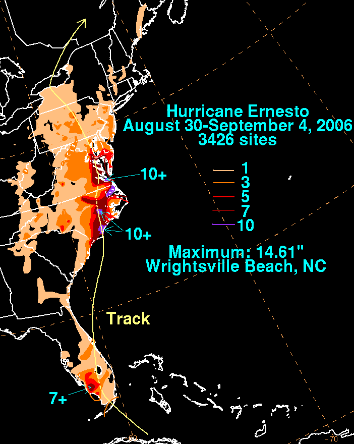
Tropical Storm Ernesto made landfall in Brunswick County
in the southern portion of North Carolina, producing a moderate storm surge
along the Pamlico River
which forced several evacuations. The storm surge reached 4–6 feet (1.2–1.8 m) in Beaufort County
, flooding many homes and businesses. Just east of where it moved ashore, the storm dropped 14.6 inches (371 mm) of rainfall in Wrightsville Beach
; this was the highest rainfall total associated with Ernesto in the United States. Much of the eastern portion of the state received over 3 inches (75 mm) of precipitation, and in the northeastern portion of the state, the precipitation caused flash flood
ing. The rainfall caused freshwater flooding in low-lying areas, as well as along major and minor roadways; the floodwaters left a 12 mi (19.3 km) portion of Interstate 40
closed in Duplin County
. Subsequent to the storm's passage, the rainfall caused severe river flooding, with many streams and rivers overflowing their banks for several days. The Northeast Cape Fear River
at Chinquapin
remained in major flood stage for a week, flooding about 300 homes.
The storm moved ashore just below hurricane strength, though wind gusts near the coast were generally around 40–60 mph (65–95 km/h). Gusts peaked at 62 mph (100 km/h) in Wilmington
, and the strong winds downed trees and power lines across the coastal region; about 69,000 people were left without power. Minor property damage was caused by three tornadoes spawned by the storm in eastern North Carolina. The passage of the storm caused a traffic fatality in the state. Overall damage was estimated at $80 million (2006 USD, $ USD), all but $4 million of which from crop damage.
 Ernesto transitioned into an extratropical cyclone
as it entered southern Virginia, bringing heavy rainfall which peaked at 10.6 inches (270 mm) in Wakefield
. The precipitation caused flash flood
ing, which closed several roads but did not cause serious damage. The interaction between Ernesto and a strong ridge
over the western Atlantic produced a tight pressure gradient, resulting in strong winds across the state; wind gusts peaked at 87 mph (141 km/h) at a station near the mouth of the York River
. Strong winds downed numerous trees, including in Gloucester where two people died after a tree hit their home. The winds caused widespread power outages; Dominion Virginia Power reported about 600,000 customers as losing power some time during the storm. The storm produced a storm tide
of 6.12 feet (1.86 m) near Virginia Beach
; along the Chesapeake Bay
, tidal flooding in combination with strong waves damaged boats and piers, and left a few homes flooded. Storm surge flooding also occurred along the Potomac River
, with heavy beach erosion, light property damage, and flooded roadways reported in Alexandria
. Across the state, the storm damaged or destroyed 609 houses, with damage totaling at least $118 million (2006 USD, $ USD). Seven people were killed in the state, of which two directly to the storm; three of the deaths were from traffic accidents, and one person died from carbon monoxide poisoning
, due to operating a power generator inside after a power outage.
In Washington, D.C., the storm produced wind gusts of up to 45 mph (75 km/h) which, in combination with heavy rainfall, resulted in a few downed tree branches and power lines. High tides left moderate damage in St. Mary's County, Maryland of about $4.4 million (2006 USD, $ USD), with the damage to trees and power lines considered worse than the impact in Hurricane Isabel
in 2003. In neighboring Charles County
, storm surge flooding forced the evacuations of houses along the waterfront. The interaction between Ernesto and a high pressure area over eastern Canada produced high winds, heavy rainfall, tidal flooding, and high waves across the Mid-Atlantic and New England. In Delaware, the winds left 151,000 people without power, and the adverse conditions canceled several Labor Day Weekend events. A buoy in the Delaware Bay
recorded a record-high wave height of 22.3 ft (6.8 m). In southern New Jersey, 80 mph (128.7 km/h) winds left over 200,000 buildings without power, while high waves flooded or closed several roads and bridges. Further north, between 2-4 inches (50–100 mm) of rain fell across Pennsylvania and New York
. In Pennsylvania, there were two deaths. A seven year-old boy died at a hospital, after a tree limb fell on him. A man was trying to rescue his golden retriever
from a drainage steam, while he was sucked into an outflow pipe, and was found dead after being pulled out of a manhole. The rain in New York caused delays in the play at the 2006 U.S. Open, and washed out a whole day's play.
The extratropical remnants of Ernesto moved across southern Ontario, dropping moderate rainfall of up to 2.1 inches (54 mm). Wind gusts reached 37 mph (60 km/h) near Toronto
, and the winds in combination with the rainfall caused power outages when lines snapped. Hundreds were left without power, though the outages were quickly restored.
, President
George W. Bush
declared 19 counties in Virginia as disaster areas, along with the cities of Richmond
and Poquoson
. The declaration allocated federal funding to assist in paying for debris removal and the rebuilding of public infrastructure damaged by Ernesto's flooding, including roads, parks, and government buildings. The city of Newport News
and four additional counties were added later in the areas eligible for federal funding. In all, FEMA
provided about $7.3 million (2006 USD, $ USD) in assistance. Although the state of Virginia applied for individual assistance, the federal government denied the request.
Due to debris and waste being carried into waterways by flooding from Ernesto, Virginia officials closed the Chesapeake Bay to shellfishing for four days from the Chesapeake Bay Bridge-Tunnel
to the mouth of the Potomac River
. In Richmond, officials condemned 70 homes, prompting city workers to establish temporary homes. By five days after the storm's passage through the state, most of the 600,000 people who experienced power outages had their electricity restored. Dominion Resources
's Tidewater Virginia area was among the most affected, requiring 2–3 days to restore all areas. By two days after the storm moved through the area, all major roadways were opened, though secondary roadways took longer to be cleared from debris.
Outside of Virginia, the Emergency Operation Centers in Pennsylvania, Delaware, and the District of Columbia were closed. Power crews worked to restore electricity to the affected areas across the region.
The NHC
's archive on Hurricane Ernesto.
The Hydrometeorological Prediction Center
's archive on Hurricane Ernesto.
The Hydrometeorological Prediction Center
's rainfall page on Ernesto
Tropical cyclone
A tropical cyclone is a storm system characterized by a large low-pressure center and numerous thunderstorms that produce strong winds and heavy rain. Tropical cyclones strengthen when water evaporated from the ocean is released as the saturated air rises, resulting in condensation of water vapor...
of the 2006 Atlantic hurricane season. The sixth tropical storm
Tropical cyclone
A tropical cyclone is a storm system characterized by a large low-pressure center and numerous thunderstorms that produce strong winds and heavy rain. Tropical cyclones strengthen when water evaporated from the ocean is released as the saturated air rises, resulting in condensation of water vapor...
and first hurricane of the season, Ernesto developed from a tropical wave
Tropical wave
Tropical waves, easterly waves, or tropical easterly waves, also known as African easterly waves in the Atlantic region, are a type of atmospheric trough, an elongated area of relatively low air pressure, oriented north to south, which move from east to west across the tropics causing areas of...
on August 24 in the eastern Caribbean Sea
Caribbean Sea
The Caribbean Sea is a sea of the Atlantic Ocean located in the tropics of the Western hemisphere. It is bounded by Mexico and Central America to the west and southwest, to the north by the Greater Antilles, and to the east by the Lesser Antilles....
. Ernesto first affected the northern Caribbean
Caribbean
The Caribbean is a crescent-shaped group of islands more than 2,000 miles long separating the Gulf of Mexico and the Caribbean Sea, to the west and south, from the Atlantic Ocean, to the east and north...
, reaching minimal hurricane status near Haiti
Haiti
Haiti , officially the Republic of Haiti , is a Caribbean country. It occupies the western, smaller portion of the island of Hispaniola, in the Greater Antillean archipelago, which it shares with the Dominican Republic. Ayiti was the indigenous Taíno or Amerindian name for the island...
before weakening and moving across eastern Cuba as a tropical storm. Despite initial predictions for it to track through the eastern Gulf of Mexico
Gulf of Mexico
The Gulf of Mexico is a partially landlocked ocean basin largely surrounded by the North American continent and the island of Cuba. It is bounded on the northeast, north and northwest by the Gulf Coast of the United States, on the southwest and south by Mexico, and on the southeast by Cuba. In...
as a major hurricane, Ernesto moved across eastern Florida as a weak tropical storm. After turning to the northeast, it re-intensified and made landfall
Landfall (meteorology)
Landfall is the event of a tropical cyclone or a waterspout coming onto land after being over water. When a waterspout makes landfall it is reclassified as a tornado, which can then cause damage inland...
on August 31 on the North Carolina coast just below hurricane status. Late the next day, Ernesto became extratropical after entering southern Virginia. The remnants spread moisture across the northeastern United States before dissipating over eastern Canada on September 4.
The deaths of at least eleven people were attributed to Ernesto, which dumped heavy rains throughout its path, especially in the Mid-Atlantic region
Mid-Atlantic States
The Mid-Atlantic states, also called middle Atlantic states or simply the mid Atlantic, form a region of the United States generally located between New England and the South...
of the United States. While moving across the Caribbean, it affected several countries, and initially Ernesto posed a threat to the Gulf Coast of the United States
Gulf Coast of the United States
The Gulf Coast of the United States, sometimes referred to as the Gulf South, South Coast, or 3rd Coast, comprises the coasts of American states that are on the Gulf of Mexico, which includes Texas, Louisiana, Mississippi, Alabama, and Florida and are known as the Gulf States...
around the one year anniversary of Hurricane Katrina
Hurricane Katrina
Hurricane Katrina of the 2005 Atlantic hurricane season was a powerful Atlantic hurricane. It is the costliest natural disaster, as well as one of the five deadliest hurricanes, in the history of the United States. Among recorded Atlantic hurricanes, it was the sixth strongest overall...
. Damage in Virginia was estimated at over $118 million (2006 USD, $ USD), prompting the declaration of a federal disaster area. Total damage in the United States
United States
The United States of America is a federal constitutional republic comprising fifty states and a federal district...
was estimated at $500 million (2006 USD, $ USD).
Meteorological history
On August 18, a tropical wave moved off the coast of AfricaAfrica
Africa is the world's second largest and second most populous continent, after Asia. At about 30.2 million km² including adjacent islands, it covers 6% of the Earth's total surface area and 20.4% of the total land area...
. It tracked westward, and its convection began organizing and concentrating on August 22. The next day, convection increased along the wave axis, and Dvorak classifications
Dvorak technique
The Dvorak technique is a widely used system to subjectively estimate tropical cyclone intensity based solely on visible and infrared satellite images. Several agencies issue Dvorak intensity numbers for cyclones of sufficient intensity...
from the Tropical Analysis and Forecast Branch of the National Hurricane Center
National Hurricane Center
The National Hurricane Center , located at Florida International University in Miami, Florida, is the division of the National Weather Service responsible for tracking and predicting weather systems within the tropics between the Prime Meridian and the 140th meridian west poleward to the 30th...
began at 1200 UTC
Coordinated Universal Time
Coordinated Universal Time is the primary time standard by which the world regulates clocks and time. It is one of several closely related successors to Greenwich Mean Time. Computer servers, online services and other entities that rely on having a universally accepted time use UTC for that purpose...
on August 23. As it approached the Lesser Antilles, a surface low
Low pressure area
A low-pressure area, or "low", is a region where the atmospheric pressure at sea level is below that of surrounding locations. Low-pressure systems form under areas of wind divergence which occur in upper levels of the troposphere. The formation process of a low-pressure area is known as...
developed, and with the confirmation of a closed low-level circulation from the Hurricane Hunters
Hurricane Hunters
The Hurricane Hunters are aircraft that fly into tropical cyclones in the North Atlantic Ocean and Northeastern Pacific Ocean for the specific purpose of directly measuring weather data in and around those storms. In the United States, the Air Force, Navy, and NOAA units have all participated in...
, it is estimated the system developed into Tropical Depression Five on August 24 about 50 mi (80.5 km) north-northwest of Grenada
Grenada
Grenada is an island country and Commonwealth Realm consisting of the island of Grenada and six smaller islands at the southern end of the Grenadines in the southeastern Caribbean Sea...
.
Located to the south of a ridge
Ridge (meteorology)
A ridge is an elongated region of relatively high atmospheric pressure, the opposite of a trough....
across the southwestern Atlantic Ocean
Atlantic Ocean
The Atlantic Ocean is the second-largest of the world's oceanic divisions. With a total area of about , it covers approximately 20% of the Earth's surface and about 26% of its water surface area...
, the depression tracked west-northwestward through an area of dry air and westerly wind shear
Wind shear
Wind shear, sometimes referred to as windshear or wind gradient, is a difference in wind speed and direction over a relatively short distance in the atmosphere...
. Despite the shear, convection intensified near the center as banding features improved, and on August 24, the depression intensified into Tropical Storm Ernesto. Convection deepened and expanded, though wind shear displaced the low-level center to the west of the convection. By August 26, the structure had become much better-defined, and within five days Ernesto was forecast to be located about 275 mi (445 km) south of the Gulf Coast of the United States as a major hurricane
Tropical cyclone scales
Tropical systems are officially ranked on one of several tropical cyclone scales according to their maximum sustained winds and in what oceanic basin they are located...
. The center reformed under the deepest convection after wind shear decreased, and at the same time outflow
Outflow (meteorology)
Outflow, in meteorology, is air that flows outwards from a storm system. It is associated with ridging, or anticyclonic flow. In the low levels of the troposphere, outflow radiates from thunderstorms in the form of a wedge of rain-cooled air, which is visible as a thin rope-like cloud on weather...
increased in all quadrants. Turning northwestward, a small eye
Eye (cyclone)
The eye is a region of mostly calm weather found at the center of strong tropical cyclones. The eye of a storm is a roughly circular area and typically 30–65 km in diameter. It is surrounded by the eyewall, a ring of towering thunderstorms where the second most severe weather of a cyclone...
formed, and early on August 27 Ernesto attained hurricane status about 95 mi (152.9 km) south-southwest of the border between Haiti and the Dominican Republic
Dominican Republic
The Dominican Republic is a nation on the island of La Hispaniola, part of the Greater Antilles archipelago in the Caribbean region. The western third of the island is occupied by the nation of Haiti, making Hispaniola one of two Caribbean islands that are shared by two countries...
.
Upon becoming a hurricane, Ernesto was believed to be undergoing rapid intensification
Rapid deepening
Rapid deepening, also known as rapid intensification, is a meteorological condition that occurs when the minimum sea-level atmospheric pressure of a tropical cyclone decreases drastically in a short period of time. The National Weather Service describes rapid deepening as a decrease of...
. However, the small inner core deteriorated as the circulation interacted with the mountainous terrain of southwest Haiti, and it quickly weakened back to tropical storm status. The center became broad and ill-defined, though it was forecast to re-intensify to hurricane status before striking Cuba. It continued to weaken due to land interaction, and early on August 28 Ernesto passed just offshore of the southwestern tip of Haiti with winds of 45 mph (72.4 km/h). Hindered by increased wind shear from an upper-level low over the Bahamas, the storm weakened further before striking just west of Guantánamo Bay in Cuba as a minimal tropical storm. With very warm water temperatures and a favorable upper-level environment, one forecast remarked the possibility of Ernesto strengthening greatly over the Straits of Florida
Straits of Florida
The Straits of Florida, Florida Straits, or Florida Strait is a strait located south-southeast of the North American mainland, generally accepted to be between the Gulf of Mexico and the Atlantic Ocean, and between the Florida Keys and Cuba. The strait carries the Florida Current, the beginning of...
and eastern Gulf of Mexico to hit western Florida as a major hurricane. Ernesto remained over land as a minimal tropical storm for about 18 hours before reaching the Straits of Florida. Convection gradually increased over the warm waters, though Ernesto failed to strengthen significantly due to its disrupted inner core. An eastward-moving high pressure system over the southeastern United States allowed a continued northwest movement, and at 0300 UTC on August 30 the storm struck Plantation Key
Plantation Key, Florida
Plantation Key, Florida is a former census-designated place on Plantation Key in the Florida Keys, in Monroe County, Florida, United States. It was reported to have a population of 4,405 in 1990. It became part of the Village of Islamorada when the latter incorporated in 1997.-External links:*...
in the upper Florida Keys
Florida Keys
The Florida Keys are a coral archipelago in southeast United States. They begin at the southeastern tip of the Florida peninsula, about south of Miami, and extend in a gentle arc south-southwest and then westward to Key West, the westernmost of the inhabited islands, and on to the uninhabited Dry...
with winds of 45 mph (72.4 km/h). Two hours later, Ernesto made landfall on the Florida mainland in southwestern Miami-Dade County
Miami-Dade County, Florida
Miami-Dade County is a county located in the southeastern part of the state of Florida. As of 2010 U.S. Census, the county had a population of 2,496,435, making it the most populous county in Florida and the eighth-most populous county in the United States...
.
National Hurricane Center
The National Hurricane Center , located at Florida International University in Miami, Florida, is the division of the National Weather Service responsible for tracking and predicting weather systems within the tropics between the Prime Meridian and the 140th meridian west poleward to the 30th...
downgraded Ernesto to tropical depression status while over the state, though post-analysis indicated the system maintained tropical storm status. Ernesto retained a well-organized cloud pattern over land, and after emerging over the Atlantic Ocean near Cape Canaveral
Cape Canaveral
Cape Canaveral, from the Spanish Cabo Cañaveral, is a headland in Brevard County, Florida, United States, near the center of the state's Atlantic coast. Known as Cape Kennedy from 1963 to 1973, it lies east of Merritt Island, separated from it by the Banana River.It is part of a region known as the...
, convection again increased and began wrapping into the circulation. Upon reaching the Atlantic Ocean, Ernesto accelerated north-northeastward ahead of an approaching deep layer trough
Trough (meteorology)
A trough is an elongated region of relatively low atmospheric pressure, often associated with fronts.Unlike fronts, there is not a universal symbol for a trough on a weather chart. The weather charts in some countries or regions mark troughs by a line. In the United States, a trough may be marked...
. The convection increased as the storm strengthened over warm waters, and late on August 31 Ernesto attained an intensity of 70 mph (112.7 km/h) while located about 170 mi (273.6 km) south-southwest of Wilmington, North Carolina
Wilmington, North Carolina
Wilmington is a port city in and is the county seat of New Hanover County, North Carolina, United States. The population is 106,476 according to the 2010 Census, making it the eighth most populous city in the state of North Carolina...
. Shortly prior to moving ashore, an eye began to develop, and early on September 1 the storm made landfall on Oak Island
Oak Island (North Carolina)
Oak Island is a barrier island on the Atlantic coast of southeastern North Carolina in Brunswick County. The island contains the towns of Oak Island and Caswell Beach as well as the North Carolina Baptist Assembly and a United States Coast Guard station, which is home to the Oak Island Lighthouse...
, North Carolina very near the threshold between tropical storm and hurricane status. The National Hurricane Center remarked the possibility that Ernesto could have been a hurricane at landfall, due to the possibility that the strongest maximum wind was not sampled.
Cold front
A cold front is defined as the leading edge of a cooler mass of air, replacing a warmer mass of air.-Development of cold front:The cooler and denser air wedges under the less-dense warmer air, lifting it...
that extended eastward through Virginia
Virginia
The Commonwealth of Virginia , is a U.S. state on the Atlantic Coast of the Southern United States. Virginia is nicknamed the "Old Dominion" and sometimes the "Mother of Presidents" after the eight U.S. presidents born there...
, Ernesto quickly lost its tropical characteristics, and late on September 1 it transitioned into an extratropical cyclone
Extratropical cyclone
Extratropical cyclones, sometimes called mid-latitude cyclones or wave cyclones, are a group of cyclones defined as synoptic scale low pressure weather systems that occur in the middle latitudes of the Earth having neither tropical nor polar characteristics, and are connected with fronts and...
. It re-intensified to a gale over the Mid-Atlantic states
Mid-Atlantic States
The Mid-Atlantic states, also called middle Atlantic states or simply the mid Atlantic, form a region of the United States generally located between New England and the South...
, only to weaken to an extratropical depression near Pennsylvania
Pennsylvania
The Commonwealth of Pennsylvania is a U.S. state that is located in the Northeastern and Mid-Atlantic regions of the United States. The state borders Delaware and Maryland to the south, West Virginia to the southwest, Ohio to the west, New York and Ontario, Canada, to the north, and New Jersey to...
. With a large high pressure area to its east, the remnants turned to the north-northwest, reaching southern Ontario
Ontario
Ontario is a province of Canada, located in east-central Canada. It is Canada's most populous province and second largest in total area. It is home to the nation's most populous city, Toronto, and the nation's capital, Ottawa....
on September 3. After turning northeastward, the extratropical remnants of Ernesto were absorbed into a larger storm over Quebec
Quebec
Quebec or is a province in east-central Canada. It is the only Canadian province with a predominantly French-speaking population and the only one whose sole official language is French at the provincial level....
on September 4.
Caribbean
About nine hours after Ernesto became a tropical storm, the government of Haiti issued a tropical storm watchTropical cyclone warnings and watches
Warnings and watches are two levels of alert issued by national weather forecasting bodies to coastal areas threatened by the imminent approach of a tropical cyclone of tropical storm or hurricane intensity. They are notices to the local population and civil authorities to make appropriate...
from its border with the Dominican Republic to the southwestern tip of the country. As the storm strengthened, the watch was replaced with a tropical storm warning, and about 15 hours prior to its closest approach the warning was replaced with a hurricane warning. Several low-lying citizens in Gonaïves
Gonaïves
Gonaïves is a city in northern Haiti, the capital of the Artibonite Department. It has a population of about 104,825 people . The city's name derives from the original Amerindian name of Gonaibo. It is also known as Haïti's "independence city"...
were evacuated after local meteorologists anticipated up to 20 inches (500 mm) of rain in some mountainous areas. Additionally, authorities advised residents in shantytowns near the ocean to evacuate to emergency shelters.
Jamaica
Jamaica
Jamaica is an island nation of the Greater Antilles, in length, up to in width and 10,990 square kilometres in area. It is situated in the Caribbean Sea, about south of Cuba, and west of Hispaniola, the island harbouring the nation-states Haiti and the Dominican Republic...
n officials issued radio and television advisories for residents in low-lying areas, urging them to be ready and evacuate if necessary. The Jamaican government opened all shelters on the island and placed its armed forces on standby. Long lines for storm supplies were reported at local businesses ahead of the storm as residents rushed to obtain supplies in preparation for Ernesto's onslaught. When a tropical storm warning was put in effect for Jamaica and the central Bahamas, cruise ship companies indicated they were diverting several liners to avoid the storm.
Hurricane warnings were put in effect for six provinces in southeastern Cuba, where significant precipitation ranging up to 20 inches (500 mm) across the mountainous south was expected as the center of Ernesto tracked slowly across Cuba. Cuban officials evacuated 300,000 people and brought its fishing fleet into harbors. The Cuban state television broadcast extensive warnings about the storm, urging precautions. Cattle were moved to higher ground, tourists were evacuated from hotels in the southeastern province of Granma
Granma Province
Granma is one of the provinces of Cuba. Its capital is Bayamo. Other towns include Manzanillo and Pilón.-History:...
, and baseball games scheduled for the evening of August 27 in Havana
Havana
Havana is the capital city, province, major port, and leading commercial centre of Cuba. The city proper has a population of 2.1 million inhabitants, and it spans a total of — making it the largest city in the Caribbean region, and the most populous...
were played earlier in the day. The threat of the storm caused domestic flights to be canceled.
United States
United States National Guard
The National Guard of the United States is a reserve military force composed of state National Guard militia members or units under federally recognized active or inactive armed force service for the United States. Militia members are citizen soldiers, meaning they work part time for the National...
was placed on standby, following a "warning order" to its commanders. On August 27, the Governor of Florida, Jeb Bush
Jeb Bush
John Ellis "Jeb" Bush is an American politician who served as the 43rd Governor of Florida from 1999 to 2007. He is a prominent member of the Bush family: the second son of former President George H. W. Bush and former First Lady Barbara Bush; the younger brother of former President George W...
, issued a state of emergency because of the high risk of impact from Ernesto on the state. Officials issued a mandatory evacuation order for all visitors and non-residents in the Florida Keys about three days before the storm passed through the area. Mandatory evacuations were later issued for mobile homes and low-lying areas of Monroe
Monroe County, Florida
Monroe County is a county located in the state of Florida. As of 2000, the population was 79,589. The U.S. Census Bureau 2006 estimate for the county was 74,737....
, Broward
Broward County, Florida
-2000 Census:As of the census of 2000, there were 1,623,018 people, 654,445 households, and 411,645 families residing in the county. The population density was 1,346 people per square mile . There were 741,043 housing units at an average density of 615 per square mile...
, St. Lucie
St. Lucie County, Florida
St. Lucie County is a county located in the state of Florida. The county seat is the city of Fort Pierce. In the year 2000, the population was 192,695. As of the year 2010, the United States Census Bureau sets the population at 277,789.- History :...
, and Martin
Martin County, Florida
Martin County is a county in the U.S. state of Florida. As of 2000, the population was 126,731. The U.S. Census Bureau 2008 estimate for the county is 138,660. Its county seat is Stuart, Florida.- History :...
counties; voluntary evacuations were also issued for barrier islands in Miami-Dade and Palm Beach
Palm Beach County, Florida
Palm Beach County is the largest county in the state of Florida in total area, and third in population. As of 2010, the county's estimated population was 1,320,134, making it the twenty-eighth most populous in the United States...
counties. On August 28, forecasters issued a hurricane watch for southern Florida through the Florida Keys. When Ernesto was downgraded to tropical storm status, Governor Jeb Bush urged Florida residents to continue preparations and not wait until it regained hurricane status, as it was forecast to do by the National Hurricane Center. At least 30 shelters were opened, and tolls on four turnpike were lifted. Several schools were closed across southern Florida. The threat of the storm caused NASA
NASA
The National Aeronautics and Space Administration is the agency of the United States government that is responsible for the nation's civilian space program and for aeronautics and aerospace research...
to postpone the launch of Space Shuttle Atlantis
Space Shuttle Atlantis
The Space Shuttle Atlantis is a retired Space Shuttle orbiter in the Space Shuttle fleet belonging to the National Aeronautics and Space Administration , the spaceflight and space exploration agency of the United States...
at Kennedy Space Center
Kennedy Space Center
The John F. Kennedy Space Center is the NASA installation that has been the launch site for every United States human space flight since 1968. Although such flights are currently on hiatus, KSC continues to manage and operate unmanned rocket launch facilities for America's civilian space program...
to avoid risking damage from the storm.
The storm was initially expected to move into the Gulf of Mexico and affect people recovering from hurricanes Katrina, Rita
Hurricane Rita
Hurricane Rita was the fourth-most intense Atlantic hurricane ever recorded and the most intense tropical cyclone ever observed in the Gulf of Mexico. Rita caused $11.3 billion in damage on the U.S. Gulf Coast in September 2005...
, and Wilma
Hurricane Wilma
Hurricane Wilma was the most intense tropical cyclone ever recorded in the Atlantic basin. Wilma was the twenty-second storm , thirteenth hurricane, sixth major hurricane, and fourth Category 5 hurricane of the record-breaking 2005 season...
in the previous year, which caused hundreds of billion in damage and left thousands of houses damaged or destroyed. There were initial fears that Ernesto would make landfall days after Hurricane Katrina's one year anniversary, and that the levees in New Orleans
Hurricane preparedness for New Orleans
Hurricane preparedness in New Orleans has been an issue since the city's early settlement because of the city's location.New Orleans was built on a delta marsh. Unlike the first two centuries of its existence, today, a little less than half of the modern city sits below sea level...
might not be able to withstand a strong storm surge
Storm surge
A storm surge is an offshore rise of water associated with a low pressure weather system, typically tropical cyclones and strong extratropical cyclones. Storm surges are caused primarily by high winds pushing on the ocean's surface. The wind causes the water to pile up higher than the ordinary sea...
. Officials in New Orleans prepared buses and trains in the event that people needed to evacuate but could not. A possible path over the Gulf of Mexico oil fields, as well as tension with Iran
Iran
Iran , officially the Islamic Republic of Iran , is a country in Southern and Western Asia. The name "Iran" has been in use natively since the Sassanian era and came into use internationally in 1935, before which the country was known to the Western world as Persia...
, caused the price of oil
Price of petroleum
The price of petroleum as quoted in news generally refers to the spot price per barrel of either WTI/light crude as traded on the New York Mercantile Exchange for delivery at Cushing, Oklahoma, or of Brent as traded on the Intercontinental Exchange for delivery at Sullom Voe.The price...
to increase, although the prices receded when the threat of the storm receded.
Altamaha River
The Altamaha River is a major river of the American state of Georgia. It flows generally eastward for 137 miles from its origin at the confluence of the Oconee River and Ocmulgee River towards the Atlantic Ocean, where it empties into the ocean near Brunswick, Georgia. There are no dams...
in Georgia
Georgia (U.S. state)
Georgia is a state located in the southeastern United States. It was established in 1732, the last of the original Thirteen Colonies. The state is named after King George II of Great Britain. Georgia was the fourth state to ratify the United States Constitution, on January 2, 1788...
to Cape Fear, North Carolina. The next day, the watch was replaced with a tropical storm warning, which was later extended to Currituck Beach Light
Currituck Beach Light
The Currituck Beach Light is a lighthouse located on the Outer Banks in Corolla, North Carolina. An example of Gothic Revival architecture, the Currituck Beach Light was added to the National Register of Historic Places on October 15, 1973.-History:...
in Corolla, North Carolina
Corolla, North Carolina
Corolla is an unincorporated community located in Poplar Branch township, Currituck County, North Carolina along the northern Outer Banks. It has a permanent population of approximately 500 people; during the summer vacation season, the population surges into the thousands...
before the storm moved ashore. In South Carolina
South Carolina
South Carolina is a state in the Deep South of the United States that borders Georgia to the south, North Carolina to the north, and the Atlantic Ocean to the east. Originally part of the Province of Carolina, the Province of South Carolina was one of the 13 colonies that declared independence...
, voluntary evacuations occurred in Charleston
Charleston County, South Carolina
Charleston County is a county located in the U.S. state of South Carolina. According to a 2005 U.S. Census Bureau estimate, its population was 330,368. Its county seat is Charleston. It is the third-most populous county in the state . Charleston County was created in 1901 by an act of the South...
and Colleton counties.
On August 31 before the storm's arrival, Virginia Governor Tim Kaine
Tim Kaine
Timothy Michael "Tim" Kaine is a Virginia politician. Kaine served as the 70th Governor of Virginia from 2006 to 2010, and was the chairman of the Democratic National Committee from 2009 to 2011...
declared a state of emergency, putting the Virginia National Guard
Virginia National Guard
The Virginia National Guard consists of the Virginia Army National Guard and the Virginia Air National Guard. It is part of the Government of Virginia though the National Guard across the United States is mostly funded by federal monies. The Constitution of the United States specifically charges...
and state agencies on alert and opening the state's new Emergency Operations Center
Emergency operations center
An emergency operations center, or EOC, is a central command and control facility responsible for carrying out the principles of emergency preparedness and emergency management, or disaster management functions at a strategic level in an emergency situation, and ensuring the continuity of operation...
in suburban Richmond
Richmond, Virginia
Richmond is the capital of the Commonwealth of Virginia, in the United States. It is an independent city and not part of any county. Richmond is the center of the Richmond Metropolitan Statistical Area and the Greater Richmond area...
. North Carolina Governor Mike Easley
Mike Easley
Michael Francis "Mike" Easley is an American politician who served as the 72nd Governor of the U.S. state of North Carolina, from 2001 to 2009. He is member of the North Carolina Democratic Party and became the first North Carolina governor to admit to a felony in a deal that halted a lengthy...
activated 200 National Guard troops and had other emergency teams on standby. Washington D.C. and parts of Maryland
Maryland
Maryland is a U.S. state located in the Mid Atlantic region of the United States, bordering Virginia, West Virginia, and the District of Columbia to its south and west; Pennsylvania to its north; and Delaware to its east...
and Delaware
Delaware
Delaware is a U.S. state located on the Atlantic Coast in the Mid-Atlantic region of the United States. It is bordered to the south and west by Maryland, and to the north by Pennsylvania...
were put on a Coastal Flood Watch and Flash Flood Watch by the National Weather Service
National Weather Service
The National Weather Service , once known as the Weather Bureau, is one of the six scientific agencies that make up the National Oceanic and Atmospheric Administration of the United States government...
in preparation for Ernesto.
Caribbean
Barbados
Barbados is an island country in the Lesser Antilles. It is in length and as much as in width, amounting to . It is situated in the western area of the North Atlantic and 100 kilometres east of the Windward Islands and the Caribbean Sea; therein, it is about east of the islands of Saint...
in association with a convective downburst
Downburst
A downburst is created by an area of significantly rain-cooled air that, after reaching ground level, spreads out in all directions producing strong winds. Unlike winds in a tornado, winds in a downburst are directed outwards from the point where it hits land or water...
. On the island, the winds downed some trees, and some flooding was reported. Strong winds and rough seas damaged six fishing boats in the southern portion of the island. Squalls in Trinidad
Trinidad
Trinidad is the larger and more populous of the two major islands and numerous landforms which make up the island nation of Trinidad and Tobago. It is the southernmost island in the Caribbean and lies just off the northeastern coast of Venezuela. With an area of it is also the fifth largest in...
left about 12 people injured after winds destroyed several tents. Also on Trinidad, the system produced widespread flooding, which resulted in some crop damage.
Puerto Rico experienced peripheral rainfall from the cyclone as it tracked through the eastern Caribbean Sea. A two-day storm total of 4.69 inches (119 mm) occurred in Sabana Grande
Sabana Grande, Puerto Rico
Sabana Grande is a municipality of Puerto Rico located north of Lajas and Guánica; south of Maricao; east of San Germán; and west of Yauco. Sabana Grande is spread over seven wards and Sabana Grande Pueblo...
.
In the Dominican Republic
Dominican Republic
The Dominican Republic is a nation on the island of La Hispaniola, part of the Greater Antilles archipelago in the Caribbean region. The western third of the island is occupied by the nation of Haiti, making Hispaniola one of two Caribbean islands that are shared by two countries...
, heavy rainfall caused river flooding and mudslides, resulting in damage to several houses. The highest rainfall report noted was 7.01 inches (178 mm) at Barahona. The rainfall also downed trees, and caused flooding to enter over 400 houses near Santo Domingo
Santo Domingo
Santo Domingo, known officially as Santo Domingo de Guzmán, is the capital and largest city in the Dominican Republic. Its metropolitan population was 2,084,852 in 2003, and estimated at 3,294,385 in 2010. The city is located on the Caribbean Sea, at the mouth of the Ozama River...
, which forced the evacuation of over 1,600 people. In Haiti, the storm caused heavy rainfall of over 11 inches (300 mm) and strong winds, causing flooding and destroying 13 homes on the island of La Gonave. In Port-au-Prince
Port-au-Prince
Port-au-Prince is the capital and largest city of the Caribbean nation of Haiti. The city's population was 704,776 as of the 2003 census, and was officially estimated to have reached 897,859 in 2009....
, rainfall severely damaged a bridge, isolating the southern portion of the region. Across the country, 59 homes were damaged, of which six destroyed, and a total of five deaths were reported.
Ernesto produced heavy rainfall in eastern Cuba, with Guantanamo
Guantánamo
Guantánamo is a municipality and city in southeast Cuba and capital of Guantánamo Province.Guantánamo is served by the Caimanera port and the site of a famous U.S. Naval base. The area produces sugarcane and cotton wool...
reporting 3 inches (75 mm) in four hours. Gusty winds left some towns in the Camagüey
Camagüey
Camagüey is a city and municipality in central Cuba and is the nation's third largest city. It is the capital of the Camagüey Province.After almost continuous attacks from pirates the original city was moved inland in 1528.The new city was built with a confusing lay-out of winding alleys that made...
Province without power, though overall damage was minor. There were no reports from Cuba of deaths, injuries, or major damage attributed to the storm.
Southeastern United States
Storm tide
A storm tide is a tide with a high flood period caused by a storm. Storm tides can be a severe danger to the coast and the people living along the coast. The water level can rise to more than 5 meters above the normal tide....
of about 1 foot (0.3 m) above astronomical tide levels, though no beach erosion was reported. Winds were fairly minor across the state, reaching 40 mph (64.4 km/h) at a station on Lake Okeechobee
Lake Okeechobee
Lake Okeechobee , locally referred to as The Lake or The Big O, is the largest freshwater lake in the state of Florida. It is the seventh largest freshwater lake in the United States and the second largest freshwater lake contained entirely within the lower 48 states...
. Ernesto dropped heavy rainfall across southwest Florida, with a state maximum of 8.72 inches (221 mm) recorded at South Golden Gate
Golden Gate, Florida
Golden Gate is a community and census-designated place in Collier County, Florida, United States. The population was 20,951 as recorded in the 2000 census...
. The rainfall caused the Fisheating Creek
Fisheating Creek
Fisheating Creek is a stream that flows into Lake Okeechobee in Florida. It is the only remaining free-flowing water course feeding into the lake, and the second-largest natural source for the lake. Most of the land surrounding the stream is either publicly owned or under conservation easements...
to overflow, and some flooding also occurred in portions of Collier County
Collier County, Florida
Collier County is a county located in the U.S. state of Florida. As of 2000, the population was 251,377. The U.S. Census Bureau 2007 estimate for the county is 315,839...
. Floodwaters entered at least 13 homes in Palmdale
Palmdale, Florida
Palmdale is an unincorporated community in Glades County, Florida, United States. It is located on US 27/State Road 25/State Road 29, just north of where US 27 and SR 29 split off from SR 25...
. The storm resulted in more than 150 canceled flights at Orlando International Airport
Orlando International Airport
Orlando International Airport is a major international airport located southeast of the central business district of Orlando. It is the second busiest airport in Florida, after Miami International Airport...
, stranding several travelers. While moving through the state, Ernesto spawned two F0
Fujita scale
The Fujita scale , or Fujita-Pearson scale, is a scale for rating tornado intensity, based primarily on the damage tornadoes inflict on human-built structures and vegetation...
tornadoes in Osceola County
Osceola County, Florida
Osceola County is a county located in the U.S. state of Florida. As of 2000, the population was 172,493. The U.S. Census Bureau 2006 estimate for the county is 244,045, making it the 17th fastest-growing county in the United States. Its county seat is Kissimmee.- History :Osceola County was...
. One person died in each in Broward and Miami-Dade counties from traffic accidents; the deaths are considered indirectly related to Ernesto. Overall damage in the state was minor.
Passing to the east of Georgia
Georgia (U.S. state)
Georgia is a state located in the southeastern United States. It was established in 1732, the last of the original Thirteen Colonies. The state is named after King George II of Great Britain. Georgia was the fourth state to ratify the United States Constitution, on January 2, 1788...
, the storm produced light winds and rainfall near the coast. In South Carolina, the storm brought over 7 inches (175 mm) of precipitation to North Myrtle Beach
North Myrtle Beach, South Carolina
North Myrtle Beach is a coastal resort city in Horry County, South Carolina, United States. It was created in 1968 from four existing municipalities north of Myrtle Beach, and serves as one of the primary tourist towns along the Grand Strand...
, which caused ponding on roadways. Winds were generally light, peaking at around 35 mph (55 km/h), which caused isolated power outages; about 2,700 people across the state lost power. Near Charleston
Charleston, South Carolina
Charleston is the second largest city in the U.S. state of South Carolina. It was made the county seat of Charleston County in 1901 when Charleston County was founded. The city's original name was Charles Towne in 1670, and it moved to its present location from a location on the west bank of the...
, the passage of the storm caused moderate flooding that left some roads closed. No significant damage was reported in the state.
Tropical Storm Ernesto made landfall in Brunswick County
Brunswick County, North Carolina
-External links:*******....
in the southern portion of North Carolina, producing a moderate storm surge
Storm surge
A storm surge is an offshore rise of water associated with a low pressure weather system, typically tropical cyclones and strong extratropical cyclones. Storm surges are caused primarily by high winds pushing on the ocean's surface. The wind causes the water to pile up higher than the ordinary sea...
along the Pamlico River
Pamlico River
The Pamlico River is a tidal river that flows into Pamlico Sound, in North Carolina in the United States of America. It is formed by the confluence of the Tar River and Tranters Creek....
which forced several evacuations. The storm surge reached 4–6 feet (1.2–1.8 m) in Beaufort County
Beaufort County, North Carolina
- Law and government :Beaufort County is a member of the Mid-East Commission regional council of governments.Beaufort County is one of the proposed sites for a Navy outlying landing field. This practice airfield would allow pilots to simulate landings on an aircraft carrier...
, flooding many homes and businesses. Just east of where it moved ashore, the storm dropped 14.6 inches (371 mm) of rainfall in Wrightsville Beach
Wrightsville Beach, North Carolina
Wrightsville Beach is a town in New Hanover County, North Carolina, United States. Wrightsville Beach is just east of Wilmington and is part of the Wilmington Metropolitan Statistical Area. The population was 2,593 at the 2000 census...
; this was the highest rainfall total associated with Ernesto in the United States. Much of the eastern portion of the state received over 3 inches (75 mm) of precipitation, and in the northeastern portion of the state, the precipitation caused flash flood
Flash flood
A flash flood is a rapid flooding of geomorphic low-lying areas—washes, rivers, dry lakes and basins. It may be caused by heavy rain associated with a storm, hurricane, or tropical storm or meltwater from ice or snow flowing over ice sheets or snowfields...
ing. The rainfall caused freshwater flooding in low-lying areas, as well as along major and minor roadways; the floodwaters left a 12 mi (19.3 km) portion of Interstate 40
Interstate 40
Interstate 40 is the third-longest major east–west Interstate Highway in the United States, after I-90 and I-80. Its western end is at Interstate 15 in Barstow, California; its eastern end is at a concurrency of U.S. Route 117 and North Carolina Highway 132 in Wilmington, North Carolina...
closed in Duplin County
Duplin County, North Carolina
-Demographics:As of the census of 2000, there were 49,063 people, 18,267 households, and 13,060 families residing in the county. The population density was 60 people per square mile . There were 20,520 housing units at an average density of 25 per square mile...
. Subsequent to the storm's passage, the rainfall caused severe river flooding, with many streams and rivers overflowing their banks for several days. The Northeast Cape Fear River
Northeast Cape Fear River
The Northeast Cape Fear River is a blackwater river tributary of the Cape Fear River, approximately 130 mi long, in southeastern North Carolina in the United States....
at Chinquapin
Chinquapin, North Carolina
Chinquapin is an unincorporated community in Duplin County, North Carolina.It is located at 34.8° N latitude and -77.82° W. longitude, at an elevation of .- References :...
remained in major flood stage for a week, flooding about 300 homes.
The storm moved ashore just below hurricane strength, though wind gusts near the coast were generally around 40–60 mph (65–95 km/h). Gusts peaked at 62 mph (100 km/h) in Wilmington
Wilmington, North Carolina
Wilmington is a port city in and is the county seat of New Hanover County, North Carolina, United States. The population is 106,476 according to the 2010 Census, making it the eighth most populous city in the state of North Carolina...
, and the strong winds downed trees and power lines across the coastal region; about 69,000 people were left without power. Minor property damage was caused by three tornadoes spawned by the storm in eastern North Carolina. The passage of the storm caused a traffic fatality in the state. Overall damage was estimated at $80 million (2006 USD, $ USD), all but $4 million of which from crop damage.
Mid-Atlantic States and Canada
Extratropical cyclone
Extratropical cyclones, sometimes called mid-latitude cyclones or wave cyclones, are a group of cyclones defined as synoptic scale low pressure weather systems that occur in the middle latitudes of the Earth having neither tropical nor polar characteristics, and are connected with fronts and...
as it entered southern Virginia, bringing heavy rainfall which peaked at 10.6 inches (270 mm) in Wakefield
Wakefield, Virginia
Wakefield is an incorporated town in Sussex County, Virginia, United States. The population was 1,038 at the 2000 census.Wakefield is famous for being the "Peanut Capital of the World" and the location of the famous , as well as the site of Airfield Conference and 4-H Educational Center...
. The precipitation caused flash flood
Flash flood
A flash flood is a rapid flooding of geomorphic low-lying areas—washes, rivers, dry lakes and basins. It may be caused by heavy rain associated with a storm, hurricane, or tropical storm or meltwater from ice or snow flowing over ice sheets or snowfields...
ing, which closed several roads but did not cause serious damage. The interaction between Ernesto and a strong ridge
Ridge (meteorology)
A ridge is an elongated region of relatively high atmospheric pressure, the opposite of a trough....
over the western Atlantic produced a tight pressure gradient, resulting in strong winds across the state; wind gusts peaked at 87 mph (141 km/h) at a station near the mouth of the York River
York River (Virginia)
The York River is a navigable estuary, approximately long, in eastern Virginia in the United States. It ranges in width from at its head to near its mouth on the west side of Chesapeake Bay. Its watershed drains an area including portions of 17 counties of the coastal plain of Virginia north...
. Strong winds downed numerous trees, including in Gloucester where two people died after a tree hit their home. The winds caused widespread power outages; Dominion Virginia Power reported about 600,000 customers as losing power some time during the storm. The storm produced a storm tide
Storm tide
A storm tide is a tide with a high flood period caused by a storm. Storm tides can be a severe danger to the coast and the people living along the coast. The water level can rise to more than 5 meters above the normal tide....
of 6.12 feet (1.86 m) near Virginia Beach
Virginia Beach, Virginia
Virginia Beach is an independent city located in the Hampton Roads metropolitan area of Virginia, on the Atlantic Ocean at the mouth of the Chesapeake Bay...
; along the Chesapeake Bay
Chesapeake Bay
The Chesapeake Bay is the largest estuary in the United States. It lies off the Atlantic Ocean, surrounded by Maryland and Virginia. The Chesapeake Bay's drainage basin covers in the District of Columbia and parts of six states: New York, Pennsylvania, Delaware, Maryland, Virginia, and West...
, tidal flooding in combination with strong waves damaged boats and piers, and left a few homes flooded. Storm surge flooding also occurred along the Potomac River
Potomac River
The Potomac River flows into the Chesapeake Bay, located along the mid-Atlantic coast of the United States. The river is approximately long, with a drainage area of about 14,700 square miles...
, with heavy beach erosion, light property damage, and flooded roadways reported in Alexandria
Alexandria, Virginia
Alexandria is an independent city in the Commonwealth of Virginia. As of 2009, the city had a total population of 139,966. Located along the Western bank of the Potomac River, Alexandria is approximately six miles south of downtown Washington, D.C.Like the rest of northern Virginia, as well as...
. Across the state, the storm damaged or destroyed 609 houses, with damage totaling at least $118 million (2006 USD, $ USD). Seven people were killed in the state, of which two directly to the storm; three of the deaths were from traffic accidents, and one person died from carbon monoxide poisoning
Carbon monoxide poisoning
Carbon monoxide poisoning occurs after enough inhalation of carbon monoxide . Carbon monoxide is a toxic gas, but, being colorless, odorless, tasteless, and initially non-irritating, it is very difficult for people to detect...
, due to operating a power generator inside after a power outage.
In Washington, D.C., the storm produced wind gusts of up to 45 mph (75 km/h) which, in combination with heavy rainfall, resulted in a few downed tree branches and power lines. High tides left moderate damage in St. Mary's County, Maryland of about $4.4 million (2006 USD, $ USD), with the damage to trees and power lines considered worse than the impact in Hurricane Isabel
Effects of Hurricane Isabel in Maryland and Washington, D.C.
The effects of Hurricane Isabel in Maryland and Washington, D.C., were among the most damaging from a tropical cyclone in the Baltimore-Washington Metropolitan Area, United States. Hurricane Isabel formed from a tropical wave on September 6, 2003, in the tropical Atlantic Ocean...
in 2003. In neighboring Charles County
Charles County, Maryland
Charles County is a county in the south central portion of the U.S. state of Maryland.As of 2010, the population was 146,551. Its county seat is La Plata. This county was named for Charles Calvert , third Baron Baltimore....
, storm surge flooding forced the evacuations of houses along the waterfront. The interaction between Ernesto and a high pressure area over eastern Canada produced high winds, heavy rainfall, tidal flooding, and high waves across the Mid-Atlantic and New England. In Delaware, the winds left 151,000 people without power, and the adverse conditions canceled several Labor Day Weekend events. A buoy in the Delaware Bay
Delaware Bay
Delaware Bay is a major estuary outlet of the Delaware River on the Northeast seaboard of the United States whose fresh water mixes for many miles with the waters of the Atlantic Ocean. It is in area. The bay is bordered by the State of New Jersey and the State of Delaware...
recorded a record-high wave height of 22.3 ft (6.8 m). In southern New Jersey, 80 mph (128.7 km/h) winds left over 200,000 buildings without power, while high waves flooded or closed several roads and bridges. Further north, between 2-4 inches (50–100 mm) of rain fell across Pennsylvania and New York
New York
New York is a state in the Northeastern region of the United States. It is the nation's third most populous state. New York is bordered by New Jersey and Pennsylvania to the south, and by Connecticut, Massachusetts and Vermont to the east...
. In Pennsylvania, there were two deaths. A seven year-old boy died at a hospital, after a tree limb fell on him. A man was trying to rescue his golden retriever
Golden Retriever
The Golden Retriever is a medium-sized breed of dog. They were historically developed as gundogs to retrieve shot waterfowl such as ducks and upland game birds during hunting and shooting parties. As such, they were bred to have a soft mouth to retrieve game undamaged and have an instinctive love...
from a drainage steam, while he was sucked into an outflow pipe, and was found dead after being pulled out of a manhole. The rain in New York caused delays in the play at the 2006 U.S. Open, and washed out a whole day's play.
The extratropical remnants of Ernesto moved across southern Ontario, dropping moderate rainfall of up to 2.1 inches (54 mm). Wind gusts reached 37 mph (60 km/h) near Toronto
Toronto
Toronto is the provincial capital of Ontario and the largest city in Canada. It is located in Southern Ontario on the northwestern shore of Lake Ontario. A relatively modern city, Toronto's history dates back to the late-18th century, when its land was first purchased by the British monarchy from...
, and the winds in combination with the rainfall caused power outages when lines snapped. Hundreds were left without power, though the outages were quickly restored.
Aftermath
On September 22, following a request from Virginia governor Tim KaineTim Kaine
Timothy Michael "Tim" Kaine is a Virginia politician. Kaine served as the 70th Governor of Virginia from 2006 to 2010, and was the chairman of the Democratic National Committee from 2009 to 2011...
, President
President of the United States
The President of the United States of America is the head of state and head of government of the United States. The president leads the executive branch of the federal government and is the commander-in-chief of the United States Armed Forces....
George W. Bush
George W. Bush
George Walker Bush is an American politician who served as the 43rd President of the United States, from 2001 to 2009. Before that, he was the 46th Governor of Texas, having served from 1995 to 2000....
declared 19 counties in Virginia as disaster areas, along with the cities of Richmond
Richmond, Virginia
Richmond is the capital of the Commonwealth of Virginia, in the United States. It is an independent city and not part of any county. Richmond is the center of the Richmond Metropolitan Statistical Area and the Greater Richmond area...
and Poquoson
Poquoson, Virginia
Poquoson is an independent city located on the Virginia Peninsula, in the Hampton Roads metropolitan area of the U.S. state of Virginia. The population was 12,150 according to the 2010 Census...
. The declaration allocated federal funding to assist in paying for debris removal and the rebuilding of public infrastructure damaged by Ernesto's flooding, including roads, parks, and government buildings. The city of Newport News
Newport News, Virginia
Newport News is an independent city located in the Hampton Roads metropolitan area of Virginia. It is at the southeastern end of the Virginia Peninsula, on the north shore of the James River extending southeast from Skiffe's Creek along many miles of waterfront to the river's mouth at Newport News...
and four additional counties were added later in the areas eligible for federal funding. In all, FEMA
Federal Emergency Management Agency
The Federal Emergency Management Agency is an agency of the United States Department of Homeland Security, initially created by Presidential Reorganization Plan No. 1 of 1978 and implemented by two Executive Orders...
provided about $7.3 million (2006 USD, $ USD) in assistance. Although the state of Virginia applied for individual assistance, the federal government denied the request.
Due to debris and waste being carried into waterways by flooding from Ernesto, Virginia officials closed the Chesapeake Bay to shellfishing for four days from the Chesapeake Bay Bridge-Tunnel
Chesapeake Bay Bridge-Tunnel
The Chesapeake Bay Bridge-Tunnel is a long fixed link crossing the mouth of the Chesapeake Bay and connecting the Delmarva Peninsula's Eastern Shore of Virginia with Virginia Beach and the metropolitan area of Hampton Roads, Virginia...
to the mouth of the Potomac River
Potomac River
The Potomac River flows into the Chesapeake Bay, located along the mid-Atlantic coast of the United States. The river is approximately long, with a drainage area of about 14,700 square miles...
. In Richmond, officials condemned 70 homes, prompting city workers to establish temporary homes. By five days after the storm's passage through the state, most of the 600,000 people who experienced power outages had their electricity restored. Dominion Resources
Dominion Resources
Dominion Resources Inc. , commonly referred to as Dominion, is a power and energy company headquartered in Richmond, Virginia that supplies electricity in parts of Virginia and North Carolina and supplies natural gas to parts of West Virginia, Ohio, Pennsylvania, and eastern North Carolina...
's Tidewater Virginia area was among the most affected, requiring 2–3 days to restore all areas. By two days after the storm moved through the area, all major roadways were opened, though secondary roadways took longer to be cleared from debris.
Outside of Virginia, the Emergency Operation Centers in Pennsylvania, Delaware, and the District of Columbia were closed. Power crews worked to restore electricity to the affected areas across the region.
See also
- Other tropical cyclones named Ernesto
- List of Florida hurricanes (2000–present)
- List of North Carolina hurricanes (2000-present)
External links
National Hurricane Center
The National Hurricane Center , located at Florida International University in Miami, Florida, is the division of the National Weather Service responsible for tracking and predicting weather systems within the tropics between the Prime Meridian and the 140th meridian west poleward to the 30th...
's archive on Hurricane Ernesto.
Hydrometeorological Prediction Center
The Hydrometeorological Prediction Center is one of nine service centers under the umbrella of the National Centers for Environmental Prediction , a part of the National Weather Service, which in turn is part of the National Oceanic and Atmospheric Administration of the U.S. government...
's rainfall page on Ernesto