
Hurricane Isabel
Encyclopedia
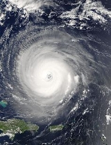
Hurricane Isabel was the costliest and deadliest hurricane
in the 2003 Atlantic hurricane season
. The ninth named storm, fifth hurricane, and second major hurricane of the season
, Isabel formed near the Cape Verde Islands
from a tropical wave
on September 6 in the tropical Atlantic Ocean
. It moved northwestward, and within an environment of light wind shear and warm waters it steadily strengthened to reach peak winds of 165 mph (265 km/h) on September 11. After fluctuating in intensity for four days, Isabel gradually weakened and made landfall on the Outer Banks
of North Carolina
with winds of 105 mph (165 km/h) on September 18. It quickly weakened over land and became extratropical
over western Pennsylvania
the next day.
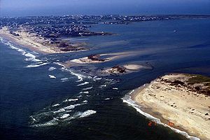
In North Carolina, the storm surge from Isabel washed out a portion of Hatteras Island
to form what was unofficially known as Isabel Inlet
. Damage was greatest along the Outer Banks, where thousands of homes were damaged or even destroyed. The worst of the effects of Isabel occurred in Virginia
, especially in the Hampton Roads
area and along the shores of rivers as far west and north as Richmond
and Washington, DC. Virginia reported the most deaths and damage from the hurricane. About 64% of the damage and 68% of the deaths occurred in North Carolina and Virginia. Electric service was disrupted in areas of Virginia for several days, some more rural areas were without electricity for weeks, and local flooding caused thousands of dollars in damage.
Moderate to severe damage extended up the Atlantic coastline and as far inland as West Virginia
. Roughly six million people were left without electric service in the eastern United States from the strong winds of Isabel. Rainfall from the storm extended from South Carolina
to Maine
, and westward to Michigan
. Throughout the path of Isabel, damage totaled about $3.6 billion (2003 USD, $ USD). 16 deaths in seven U.S. states were directly related to the hurricane, with 35 deaths in six states and one Canadian province indirectly related to the hurricane.
moved off the coast of Africa
on September 1. An area of low pressure
associated with the wave moved slowly westward, and its convection initially appeared to become better organized. On September 3, as it passed to the south of the Cape Verde
islands, organization within the system degraded, though convection increased the next day. The system gradually became better organized, and Dvorak classifications
began early on September 5. Based on the development of a closed surface circulation, it is estimated the system developed into Tropical Depression Thirteen early on September 6. Hours later, it intensified into Tropical Storm Isabel, though operationally the National Hurricane Center
did not begin issuing advisories until 13 hours after it first developed.
Located within an area of light wind shear
and warm waters, Isabel gradually organized as curved bands developed around a circular area of deep convection near the center. It steadily strengthened as it moved to the west-northwest, and Isabel strengthened to a hurricane on September 7 subsequent to the development of a large, yet ragged eye
located near the deepest convection. The eye, overall convective pattern, and outflow steadily improved in organization, and deep convection quickly surrounded the 40 miles (64.4 km)-wide eye. Isabel intensified on September 8 to reach major hurricane status while located 1,300 miles (2,100 km) east-northeast of Barbuda
. On September 9, Isabel reached a primary peak intensity of 135 mph (215 km/h) for around 24 hours, a minimal Category 4 hurricane on the Saffir-Simpson Scale
.
 Early on September 10, the eyewall became less defined, the convection near the eye became eroded, and northeasterly outflow became slightly restricted. As a result, Isabel weakened slightly to a Category 3 hurricane. The hurricane turned more to the west due to the influence of the Bermuda-Azores High
. Later on September 10, Isabel restrengthened to a Category 4 hurricane after convection deepened near the increasingly organizing eyewall. The hurricane continued to intensify, and Isabel reached its peak intensity of 165 mph (270 km/h) on September 11, a Category 5 hurricane on the Saffir-Simpson Scale
. Due to an Eyewall replacement cycle
, Isabel weakened slightly, though it retained Category 5 status for 24 hours. As Isabel underwent another eyewall replacement cycle, outflow degraded in appearance and convection around the eye weakened, and early on September 13 Isabel weakened to a strong Category 4 hurricane. A weakness in the ridge to its north allowed the hurricane to turn to the west-northwest. After completing the replacement cycle, the hurricane's large 40 mile (65 km) wide eye became better defined, and late on the 13th Isabel re-attained Category 5 status. A NOAA Hurricane Hunter Reconnaissance Aircraft flying into the hurricane launched a dropsonde
which measured an instantaneous wind speed of 233 mi/h, the strongest instantaneous wind speed recorded in an Atlantic hurricane. Cloud tops warmed again shortly thereafter, and Isabel weakened to a strong Category 4 hurricane early on September 14. Later that day, it re-organized, and for the third time it attained Category 5 status while located 400 miles (650 km) north of San Juan, Puerto Rico
.
 Cloud tops around the center resulted in Isabel weakening to a Category 4 hurricane early on September 15. Later that day, the inner core of deep convection began to deteriorate while the eye decayed in appearance. As a ridge
to its northwest build southeastward, it resulted in Isabel decelerating as it turned to the north-northwest. Increasing vertical wind shear
contributed in weakening the hurricane further, and Isabel weakened to a Category 2 hurricane on September 16 while located 645 miles (1035 km) southeast of Cape Hatteras
, North Carolina
. Convection remained minimal, though outflow retained excellent organization, and Isabel remained a Category 2 hurricane for two days until making landfall between Cape Lookout
and Ocracoke Island on September 18 with winds of 105 mph (165 km/h). It weakened after it made landfall, though due to its fast forward motion Isabel remained a hurricane until reaching western Virginia
early on September 19. After passing through West Virginia
as a tropical storm, Isabel became extratropical over Western Pennsylvania
including Pittsburgh. Later that day, it crossed Lake Erie
into Canada
, and was absorbed by a larger extratropical storm over the Cochrane District
of Ontario
.
.jpg) 50 hours prior to Isabel making landfall, the National Hurricane Center
50 hours prior to Isabel making landfall, the National Hurricane Center
issued a hurricane watch
from Little River, South Carolina
to Chincoteague, Virginia
, including the Pamlico
and Albemarle Sound
s and the lower Chesapeake Bay
. The NHC also issued a tropical storm watch south of Little River, South Carolina to the mouth of the Santee River
, as well as from Chincoteague, Virginia northward to Little Egg Inlet
, New Jersey
. Hurricane and tropical storm warnings were gradually issued for portions of the East Coast of the United States
. By the time Isabel made landfall, a tropical storm warning existed from Chincoteague, Virginia to Fire Island, New York
and from Cape Fear, North Carolina
to the mouth of the Santee River in South Carolina, and a hurricane warning existed from Chincoteague, Virginia to Cape Fear. Landfall forecasts were very accurate; from three days prior, the average track forecast error for its landfall was only 36 miles (58 km), and for 48 hours in advance the average track error was 18 miles (29 km).
Officials declared mandatory evacuations for 24 counties in North Carolina
, Virginia
, and Maryland
, though in general not many left. According to a survey conducted by the United States Department of Commerce, evacuation rates were estimated as follows; 45% in the Outer Banks
, 23% in the area around the Pamlico Sound
, 23% in Virginia
, and about 15% in Maryland
. The threat of Isabel resulted in the evacuation of hundreds of thousands of residents, primarily in North Carolina and Virginia, and included more than 12,000 residents staying in emergency shelters.
19 major airports along the East Coast of the United States
were closed, with more than 1,500 flights canceled. The Washington Metro
and Metrobus
system closed prior to the arrival of the storm, and Amtrak
canceled nearly all trains south of the nation's capital. Schools and businesses throughout its path closed prior to Isabel's arrival to allow time to prepare; hardware and home improvement stores reported brisk business of plywood, flashlights, batteries, and portable generators, as residents prepared for the storm's potential impact. The federal government was closed excluding emergency staff members. The United States Navy
ordered the removal of 40 ships and submarines and dozens of aircraft from naval sites near Norfolk, Virginia
.
Strong winds from Isabel extended from North Carolina
to New England
and westward to West Virginia
. The winds, combined with previous rainfall which moistened the soil, downed many trees and power lines across its path, leaving about 6 million electricity customers without power at some point. Parts of coastal Virginia
, especially in the Hampton Roads
and Northeast North Carolina
areas, were without electricity
for almost a month. Coastal areas suffered from waves and its powerful storm surge, with areas in eastern North Carolina and southeast Virginia
reporting severe damage from both winds and the storm surge. Throughout its path, Isabel resulted in $3.6 billion in damage (2003 USD, $ USD) and 51 deaths, of which 16 were directly related to the storm's effects.
The governors of Pennsylvania
, West Virginia
, Maryland
, New Jersey
, and Delaware
declared states of emergency. Isabel was the first major hurricane to threaten the Mid-Atlantic States
and the Upper South since Hurricane Floyd
in September 1999. Isabel's greatest effect was due to flood
damage, the worst in some areas of Virginia
since 1972's Hurricane Agnes
. More than 60 million people were affected to some degree—a similar number to Floyd but more than any other hurricane in recent memory.
. Strong swells also lashed the Bahamas. During most hurricanes, the location of the Bahamas prevents powerful swells of Atlantic hurricanes from striking southeast Florida
. However, the combination of the location, forward speed, and strength of Isabel produced strong swells through the Providence Channel
onto a narrow 10 mile (16 km) stretch of the southeastern Florida coastline; wave heights peaked at 14 feet (4.3 m) at Delray Beach
. The swells capsized a watercraft and injured its two passengers at Boynton Beach
, and a swimmer required assistance to be rescued near Juno Beach
. Minor beach erosion was reported in Palm Beach County
. In the northern portion of the state, waves reached up to 15 feet (4.5 m) in height at Flagler Beach
, causing the Flagler Beach Pier to be closed due to damaged boards from the waves. Rip currents from Isabel killed a surfer at an unguarded beach in Nassau County
, with an additional six people requiring rescue from the currents. The beaches were later closed during the worst of the rough surf.
In northeastern South Carolina
, the outer rainband
s produced moderate winds reaching 45 mph (72 km/h) at Myrtle Beach
. Rainfall was light, peaking at 1.34 inches (34 mm) in Loris
.
.jpg) Isabel produced moderate to heavy damage across eastern North Carolina, totaling $450 million (2003 USD
Isabel produced moderate to heavy damage across eastern North Carolina, totaling $450 million (2003 USD
, $ USD). Damage was heaviest in Dare County
, where storm surge flooding and strong winds damaged thousands of houses. The storm surge produced a 2,000 foot (600 m) wide inlet on Hatteras Island
, unofficially known as Isabel Inlet
, isolating Hatteras
by road for two months. Strong winds downed hundreds of trees of across the state, leaving up to 700,000 residents without power. Most areas with power outages had power restored within a few days. The hurricane directly killed one person and indirectly killed two in the state.
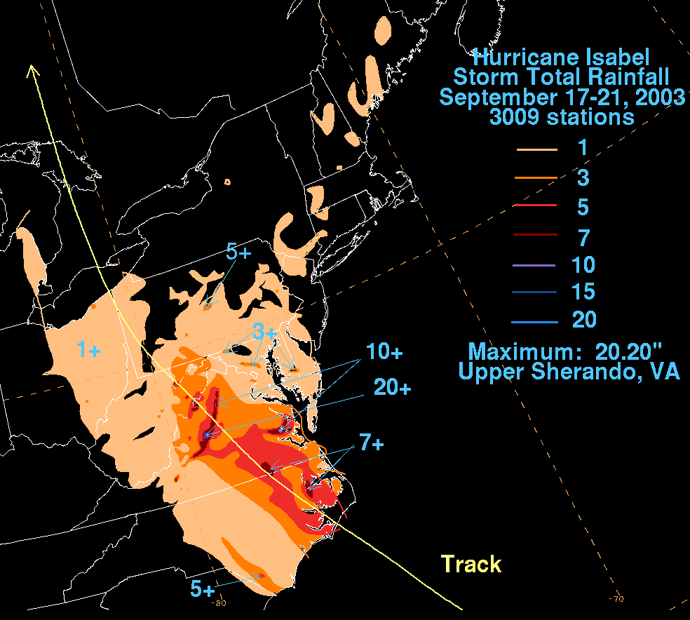
 The storm surge
assailed much of southeastern Virginia, peaking at an estimated 9 feet (2.7 m) in Richmond
along the James River
; the surge caused significant damage to homes along river ways, especially along the middle reaches of the James River basin. The strong storm surge surpassed the floodgate to the Midtown Tunnel while workers attempted to close the gate; about 44 million USgals (166,558.1 m³) of water flooded the tunnel entirely in just 40 minutes, with the workers barely able to escape. The damage to the electrical grid and flooding kept Old Dominion University
, Norfolk State University
and many of the region's other major educational institutions closed for almost a week. Further inland, heavy rainfall was reported, peaking at 20.2 inches (513 mm) in Upper Sherando, causing damage and severe flash flood
ing. Winds from the hurricane destroyed over 1,000 houses and damaged 9,000 more; damage in the state totaled about $1.85 billion (2003 USD, $ USD), among the costliest tropical cyclones in Virginia history. The passage of Isabel also resulted in 32 deaths in the state, 10 directly from the storm's effects and 22 indirectly related.
About 1.24 million people lost power throughout Maryland
and Washington, D.C.
The worst of Isabel's effects came from its storm surge, which inundated areas along the coast and resulted in severe beach erosion. In Eastern Maryland
, hundreds of buildings were damaged or destroyed by the storm surge and related tidal flooding. The most severe flooding occurred in the southern portions of Dorchester and Somerset counties and on Kent Island in Queen Anne's County. Thousands of houses were affected in Central Maryland, with severe storm surge flooding reported in Baltimore and Annapolis
. Washington, D.C. sustained moderate damage, primarily from the winds. Throughout Maryland and Washington, damage totaled about $945 million (2003 USD, $ USD), with only one direct fatality due to flooding.
The effects of the hurricane in Delaware
were compounded by flooding caused by the remnants of Tropical Storm Henri
days before. Moderate winds of up to 62 mph (100 km/h) in Lewes
downed numerous trees, tree limbs, and power lines across the state, leaving at least 15,300 without power. Numerous low-lying areas were flooded due to high surf, strong storm surge, or run-off from flooding further inland. The passage of Hurricane Isabel resulted in $40 million in damage (2003 USD, $ USD) and no casualties in the state.
 The winds from Isabel downed hundreds of trees and power lines across New Jersey
, leaving hundreds of thousands without power; a falling tree killed one person. Rough waves and a moderate storm surge along the coastline caused moderate to severe beach erosion, and one person was killed from the rough waves. Damage in the state totaled $50 million (2003 USD, $ USD).
The passage of Hurricane Isabel in Pennsylvania
resulted in $160 million in damage (2003 USD, $ USD) and 2 indirect deaths in Pennsylvania
. One person suffered from carbon monoxide poisoning, believed to be caused due to improperly ventilated generators in an area affected by the power outages. Moderate winds left about 1.4 million customers without power across the state as a result of trees falling into power lines, with dozens of houses and cars damaged by the trees.
Damage in New York
totaled $90 million (2003 USD, $ USD), with Vermont reporting about $100,000 in damage (2003 USD, $ USD). Falling trees from moderate winds downed power lines across the region, causing sporadic power outages. Two people died in the region as a result of the hurricane, both due to the rough surf from Isabel.
, the storm produced moderate rainfall across the state that peaked at 6.88 in (174.8 mm) near Sugar Grove
. The rainfall resulted in mudslides and flash flooding, covering several roads and washing away two bridges. The South Branch Potomac River crested at 24.7 feet (7.5 m), 9.3 feet (2.8 m) above flood state near Springfield
. The flooding broke a levee at Michael Field, and in Mineral County one school and 14 basements were flooded. In Jefferson County
, two people required rescue after a car drove into floodwaters. Although sustained winds were weak in the state, wind gusts reached 46 mi/h at Martinsburg
. With the wet grounds, the wind gusts toppled thousands of trees, which fell onto homes, roads, and power lines. About 1.4 million residents across the state were left without power. Damage in the state totaled $20 million (2003 USD, $ USD). No deaths were reported, and three were injured from the hurricane.
Isabel dropped light to moderate precipitation across the eastern half of Ohio
, with isolated locations reporting over 3 in (75 mm). Moisture from Isabel dropped light rainfall across eastern Michigan
and peaked at 1.55 inches (39 mm) at Mount Clemens
. Additionally, Doppler weather radar
estimated rainfall approached 2.5 inches (64 mm) in St. Clair County
. No damage was reported from Isabel in the region.
Canada
was slightly affected by Isabel. High winds downed trees and power lines across southern Ontario, resulting in several power outages. Rainfall from the storm first began affecting Ontario early on September 19. Isabel was indirectly responsible for two traffic fatalities. A group of researchers flew into Isabel over Lake Erie and southern Ontario to study tropical cyclones transitioning into extratropical cyclones. The group also flew into two previous cyclones affecting Canada.
By about a week after the passage of the hurricane, President
George W. Bush
declared disaster areas for 36 North Carolina counties, 77 counties and independent cities in Virginia
, the entire state of Maryland
, all three counties in Delaware
and six West Virginia counties. The disaster declaration allocated the use of federal funds for rebuilding and providing aid in the aftermath of hurricane Isabel. By about four months after the passage of the hurricane, disaster aid totaled about $516 million (2003 USD, $ USD), primarily in North Carolina and Virginia. Over 166,000 residents applied for individual assistance, with about $117 million (2003 USD, $ USD) approved for residents to assist with temporary housing and home repairs. About 50,000 business owners applied for Small Business Administration loans, with about $178 million (2003 USD, $ USD) approved for the assistance loans. About 40,000 people visited local disaster recovery centers, designed to provide additional information regarding the aftermath of the hurricane.
In North Carolina
, hundreds of residents were stranded in Hatteras
following the formation of Isabel Inlet
. People who were not residents were not allowed to be on the Outer Banks for two weeks after the hurricane due to damaged road conditions. When visitors were allowed to return, many ventured to see the new inlet, despite a 1-mile (1.6-km) walk from the nearest road. Initially, long term solutions to the Isabel Inlet such as building a bridge or a ferry system were considered, though they were ultimately canceled in favor of pumping sand and filling the inlet. Coastal geologists were opposed to the solution, stating the evolution of the Outer Banks is dependent on inlets from hurricanes. Dredging operations began on October 17, about a month after the hurricane struck. The United States Geological Survey
used sand from the ferry channel to the southwest of Hatteras Island, a choice made to minimize the impact to submerged aquatic vegetation and due to the channel being filled somewhat during the hurricane. On November 22, about two months after the hurricane struck, North Carolina Highway 12 and Hatteras Island were reopened to public access. On the same day, the ferry between Hatteras and Ocracoke was reopened.
In West Virginia, the power outages were restored within a week.
Because of widespread property damage and extensive death tolls the name "Isabel" was retired after the 2003 season, and will not be used for future Atlantic hurricanes. It was replaced by "Ida"
for the naming list for the 2009 season
. The names Ina and Ivy were also suggested as possible replacement names.
Tropical cyclone
A tropical cyclone is a storm system characterized by a large low-pressure center and numerous thunderstorms that produce strong winds and heavy rain. Tropical cyclones strengthen when water evaporated from the ocean is released as the saturated air rises, resulting in condensation of water vapor...
in the 2003 Atlantic hurricane season
2003 Atlantic hurricane season
The 2003 Atlantic hurricane season was an active Atlantic hurricane season with tropical activity before and after the official bounds of the season – the first such occurrence in 50 years. The season produced 21 tropical cyclones, of which 16 developed into named storms; seven...
. The ninth named storm, fifth hurricane, and second major hurricane of the season
Atlantic hurricane season
The Atlantic hurricane season is the period in a year when hurricanes usually form in the Atlantic Ocean. Tropical cyclones in the North Atlantic are called hurricanes, tropical storms, or tropical depressions. In addition, there have been several storms over the years that have not been fully...
, Isabel formed near the Cape Verde Islands
Cape Verde-type hurricane
A Cape Verde-type hurricane is an Atlantic hurricane that develops near the Cape Verde islands, off the west coast of Africa. The average hurricane season has about two Cape Verde-type hurricanes, which are usually the largest and most intense storms of the season because they often have plenty of...
from a tropical wave
Tropical wave
Tropical waves, easterly waves, or tropical easterly waves, also known as African easterly waves in the Atlantic region, are a type of atmospheric trough, an elongated area of relatively low air pressure, oriented north to south, which move from east to west across the tropics causing areas of...
on September 6 in the tropical Atlantic Ocean
Atlantic Ocean
The Atlantic Ocean is the second-largest of the world's oceanic divisions. With a total area of about , it covers approximately 20% of the Earth's surface and about 26% of its water surface area...
. It moved northwestward, and within an environment of light wind shear and warm waters it steadily strengthened to reach peak winds of 165 mph (265 km/h) on September 11. After fluctuating in intensity for four days, Isabel gradually weakened and made landfall on the Outer Banks
Outer Banks
The Outer Banks is a 200-mile long string of narrow barrier islands off the coast of North Carolina, beginning in the southeastern corner of Virginia Beach on the east coast of the United States....
of North Carolina
North Carolina
North Carolina is a state located in the southeastern United States. The state borders South Carolina and Georgia to the south, Tennessee to the west and Virginia to the north. North Carolina contains 100 counties. Its capital is Raleigh, and its largest city is Charlotte...
with winds of 105 mph (165 km/h) on September 18. It quickly weakened over land and became extratropical
Extratropical cyclone
Extratropical cyclones, sometimes called mid-latitude cyclones or wave cyclones, are a group of cyclones defined as synoptic scale low pressure weather systems that occur in the middle latitudes of the Earth having neither tropical nor polar characteristics, and are connected with fronts and...
over western Pennsylvania
Pennsylvania
The Commonwealth of Pennsylvania is a U.S. state that is located in the Northeastern and Mid-Atlantic regions of the United States. The state borders Delaware and Maryland to the south, West Virginia to the southwest, Ohio to the west, New York and Ontario, Canada, to the north, and New Jersey to...
the next day.
In North Carolina, the storm surge from Isabel washed out a portion of Hatteras Island
Hatteras Island
Hatteras Island is a barrier island located off the North Carolina coast. Dividing the Atlantic Ocean and the Pamlico Sound, it runs parallel to the coast, forming a bend at Cape Hatteras. It is part of North Carolina's Outer Banks and includes the towns of Rodanthe, Waves, Salvo, Avon, Buxton,...
to form what was unofficially known as Isabel Inlet
Isabel Inlet
Isabel Inlet was an informally named inlet along the Outer Banks of North Carolina. It was created by Hurricane Isabel when it swept ashore on September 18, 2003....
. Damage was greatest along the Outer Banks, where thousands of homes were damaged or even destroyed. The worst of the effects of Isabel occurred in Virginia
Virginia
The Commonwealth of Virginia , is a U.S. state on the Atlantic Coast of the Southern United States. Virginia is nicknamed the "Old Dominion" and sometimes the "Mother of Presidents" after the eight U.S. presidents born there...
, especially in the Hampton Roads
Hampton Roads
Hampton Roads is the name for both a body of water and the Norfolk–Virginia Beach metropolitan area which surrounds it in southeastern Virginia, United States...
area and along the shores of rivers as far west and north as Richmond
Richmond, Virginia
Richmond is the capital of the Commonwealth of Virginia, in the United States. It is an independent city and not part of any county. Richmond is the center of the Richmond Metropolitan Statistical Area and the Greater Richmond area...
and Washington, DC. Virginia reported the most deaths and damage from the hurricane. About 64% of the damage and 68% of the deaths occurred in North Carolina and Virginia. Electric service was disrupted in areas of Virginia for several days, some more rural areas were without electricity for weeks, and local flooding caused thousands of dollars in damage.
Moderate to severe damage extended up the Atlantic coastline and as far inland as West Virginia
West Virginia
West Virginia is a state in the Appalachian and Southeastern regions of the United States, bordered by Virginia to the southeast, Kentucky to the southwest, Ohio to the northwest, Pennsylvania to the northeast and Maryland to the east...
. Roughly six million people were left without electric service in the eastern United States from the strong winds of Isabel. Rainfall from the storm extended from South Carolina
South Carolina
South Carolina is a state in the Deep South of the United States that borders Georgia to the south, North Carolina to the north, and the Atlantic Ocean to the east. Originally part of the Province of Carolina, the Province of South Carolina was one of the 13 colonies that declared independence...
to Maine
Maine
Maine is a state in the New England region of the northeastern United States, bordered by the Atlantic Ocean to the east and south, New Hampshire to the west, and the Canadian provinces of Quebec to the northwest and New Brunswick to the northeast. Maine is both the northernmost and easternmost...
, and westward to Michigan
Michigan
Michigan is a U.S. state located in the Great Lakes Region of the United States of America. The name Michigan is the French form of the Ojibwa word mishigamaa, meaning "large water" or "large lake"....
. Throughout the path of Isabel, damage totaled about $3.6 billion (2003 USD, $ USD). 16 deaths in seven U.S. states were directly related to the hurricane, with 35 deaths in six states and one Canadian province indirectly related to the hurricane.
Meteorological history
A tropical waveTropical wave
Tropical waves, easterly waves, or tropical easterly waves, also known as African easterly waves in the Atlantic region, are a type of atmospheric trough, an elongated area of relatively low air pressure, oriented north to south, which move from east to west across the tropics causing areas of...
moved off the coast of Africa
Africa
Africa is the world's second largest and second most populous continent, after Asia. At about 30.2 million km² including adjacent islands, it covers 6% of the Earth's total surface area and 20.4% of the total land area...
on September 1. An area of low pressure
Low pressure area
A low-pressure area, or "low", is a region where the atmospheric pressure at sea level is below that of surrounding locations. Low-pressure systems form under areas of wind divergence which occur in upper levels of the troposphere. The formation process of a low-pressure area is known as...
associated with the wave moved slowly westward, and its convection initially appeared to become better organized. On September 3, as it passed to the south of the Cape Verde
Cape Verde
The Republic of Cape Verde is an island country, spanning an archipelago of 10 islands located in the central Atlantic Ocean, 570 kilometres off the coast of Western Africa...
islands, organization within the system degraded, though convection increased the next day. The system gradually became better organized, and Dvorak classifications
Dvorak technique
The Dvorak technique is a widely used system to subjectively estimate tropical cyclone intensity based solely on visible and infrared satellite images. Several agencies issue Dvorak intensity numbers for cyclones of sufficient intensity...
began early on September 5. Based on the development of a closed surface circulation, it is estimated the system developed into Tropical Depression Thirteen early on September 6. Hours later, it intensified into Tropical Storm Isabel, though operationally the National Hurricane Center
National Hurricane Center
The National Hurricane Center , located at Florida International University in Miami, Florida, is the division of the National Weather Service responsible for tracking and predicting weather systems within the tropics between the Prime Meridian and the 140th meridian west poleward to the 30th...
did not begin issuing advisories until 13 hours after it first developed.
Located within an area of light wind shear
Wind shear
Wind shear, sometimes referred to as windshear or wind gradient, is a difference in wind speed and direction over a relatively short distance in the atmosphere...
and warm waters, Isabel gradually organized as curved bands developed around a circular area of deep convection near the center. It steadily strengthened as it moved to the west-northwest, and Isabel strengthened to a hurricane on September 7 subsequent to the development of a large, yet ragged eye
Eye (cyclone)
The eye is a region of mostly calm weather found at the center of strong tropical cyclones. The eye of a storm is a roughly circular area and typically 30–65 km in diameter. It is surrounded by the eyewall, a ring of towering thunderstorms where the second most severe weather of a cyclone...
located near the deepest convection. The eye, overall convective pattern, and outflow steadily improved in organization, and deep convection quickly surrounded the 40 miles (64.4 km)-wide eye. Isabel intensified on September 8 to reach major hurricane status while located 1,300 miles (2,100 km) east-northeast of Barbuda
Barbuda
Barbuda is an island in the Eastern Caribbean, and forms part of the state of Antigua and Barbuda. It has a population of about 1,500, most of whom live in the town of Codrington.-Location:...
. On September 9, Isabel reached a primary peak intensity of 135 mph (215 km/h) for around 24 hours, a minimal Category 4 hurricane on the Saffir-Simpson Scale
Saffir-Simpson Hurricane Scale
The Saffir–Simpson Hurricane Scale , or the Saffir–Simpson Hurricane Wind Scale , classifies hurricanes — Western Hemisphere tropical cyclones that exceed the intensities of tropical depressions and tropical storms — into five categories distinguished by the intensities of their sustained winds...
.
Subtropical ridge
The subtropical ridge is a significant belt of high pressure situated around the latitudes of 30°N in the Northern Hemisphere and 30°S in the Southern Hemisphere. It is characterized by mostly calm winds, which acts to reduce air quality under its axis by causing fog overnight, and haze during...
. Later on September 10, Isabel restrengthened to a Category 4 hurricane after convection deepened near the increasingly organizing eyewall. The hurricane continued to intensify, and Isabel reached its peak intensity of 165 mph (270 km/h) on September 11, a Category 5 hurricane on the Saffir-Simpson Scale
Saffir-Simpson Hurricane Scale
The Saffir–Simpson Hurricane Scale , or the Saffir–Simpson Hurricane Wind Scale , classifies hurricanes — Western Hemisphere tropical cyclones that exceed the intensities of tropical depressions and tropical storms — into five categories distinguished by the intensities of their sustained winds...
. Due to an Eyewall replacement cycle
Eyewall replacement cycle
Eyewall replacement cycles, also called concentric eyewall cycles, naturally occur in intense tropical cyclones, generally with winds greater than 185 km/h , or major hurricanes...
, Isabel weakened slightly, though it retained Category 5 status for 24 hours. As Isabel underwent another eyewall replacement cycle, outflow degraded in appearance and convection around the eye weakened, and early on September 13 Isabel weakened to a strong Category 4 hurricane. A weakness in the ridge to its north allowed the hurricane to turn to the west-northwest. After completing the replacement cycle, the hurricane's large 40 mile (65 km) wide eye became better defined, and late on the 13th Isabel re-attained Category 5 status. A NOAA Hurricane Hunter Reconnaissance Aircraft flying into the hurricane launched a dropsonde
Dropsonde
A dropsonde is a weather reconnaissance device created by the National Center for Atmospheric Research , designed to be dropped from an aircraft at altitude to more accurately measure tropical storm conditions as the device falls to the surface...
which measured an instantaneous wind speed of 233 mi/h, the strongest instantaneous wind speed recorded in an Atlantic hurricane. Cloud tops warmed again shortly thereafter, and Isabel weakened to a strong Category 4 hurricane early on September 14. Later that day, it re-organized, and for the third time it attained Category 5 status while located 400 miles (650 km) north of San Juan, Puerto Rico
San Juan, Puerto Rico
San Juan , officially Municipio de la Ciudad Capital San Juan Bautista , is the capital and most populous municipality in Puerto Rico, an unincorporated territory of the United States. As of the 2010 census, it had a population of 395,326 making it the 46th-largest city under the jurisdiction of...
.
Ridge (meteorology)
A ridge is an elongated region of relatively high atmospheric pressure, the opposite of a trough....
to its northwest build southeastward, it resulted in Isabel decelerating as it turned to the north-northwest. Increasing vertical wind shear
Wind shear
Wind shear, sometimes referred to as windshear or wind gradient, is a difference in wind speed and direction over a relatively short distance in the atmosphere...
contributed in weakening the hurricane further, and Isabel weakened to a Category 2 hurricane on September 16 while located 645 miles (1035 km) southeast of Cape Hatteras
Cape Hatteras
Cape Hatteras is a cape on the coast of North Carolina. It is the point that protrudes the farthest to the southeast along the northeast-to-southwest line of the Atlantic coast of North America...
, North Carolina
North Carolina
North Carolina is a state located in the southeastern United States. The state borders South Carolina and Georgia to the south, Tennessee to the west and Virginia to the north. North Carolina contains 100 counties. Its capital is Raleigh, and its largest city is Charlotte...
. Convection remained minimal, though outflow retained excellent organization, and Isabel remained a Category 2 hurricane for two days until making landfall between Cape Lookout
Cape Lookout (North Carolina)
This article is about the Cape Lookout in North Carolina. See Cape Lookout for other places with a similar name. Cape Lookout is southern point of the Core Banks, one of the natural barrier islands on the Atlantic coast of North Carolina, USA. delimits Onslow Bay to the west from Raleigh Bay to...
and Ocracoke Island on September 18 with winds of 105 mph (165 km/h). It weakened after it made landfall, though due to its fast forward motion Isabel remained a hurricane until reaching western Virginia
Virginia
The Commonwealth of Virginia , is a U.S. state on the Atlantic Coast of the Southern United States. Virginia is nicknamed the "Old Dominion" and sometimes the "Mother of Presidents" after the eight U.S. presidents born there...
early on September 19. After passing through West Virginia
West Virginia
West Virginia is a state in the Appalachian and Southeastern regions of the United States, bordered by Virginia to the southeast, Kentucky to the southwest, Ohio to the northwest, Pennsylvania to the northeast and Maryland to the east...
as a tropical storm, Isabel became extratropical over Western Pennsylvania
Western Pennsylvania
Western Pennsylvania consists of the western third of the state of Pennsylvania in the United States. Pittsburgh is the largest city in the region, with a metropolitan area population of about 2.4 million people, and serves as its economic and cultural center. Erie, Altoona, and Johnstown are its...
including Pittsburgh. Later that day, it crossed Lake Erie
Lake Erie
Lake Erie is the fourth largest lake of the five Great Lakes in North America, and the tenth largest globally. It is the southernmost, shallowest, and smallest by volume of the Great Lakes and therefore also has the shortest average water residence time. It is bounded on the north by the...
into Canada
Canada
Canada is a North American country consisting of ten provinces and three territories. Located in the northern part of the continent, it extends from the Atlantic Ocean in the east to the Pacific Ocean in the west, and northward into the Arctic Ocean...
, and was absorbed by a larger extratropical storm over the Cochrane District
Cochrane District, Ontario
Cochrane District, Ontario is a district and census division in Northeastern Ontario in the Canadian province of Ontario. It was created in 1921 from parts of Timiskaming and Thunder Bay districts....
of Ontario
Ontario
Ontario is a province of Canada, located in east-central Canada. It is Canada's most populous province and second largest in total area. It is home to the nation's most populous city, Toronto, and the nation's capital, Ottawa....
.
Preparations
National Hurricane Center
The National Hurricane Center , located at Florida International University in Miami, Florida, is the division of the National Weather Service responsible for tracking and predicting weather systems within the tropics between the Prime Meridian and the 140th meridian west poleward to the 30th...
issued a hurricane watch
Tropical cyclone warnings and watches
Warnings and watches are two levels of alert issued by national weather forecasting bodies to coastal areas threatened by the imminent approach of a tropical cyclone of tropical storm or hurricane intensity. They are notices to the local population and civil authorities to make appropriate...
from Little River, South Carolina
Little River, South Carolina
Little River is a census-designated place in Horry County, South Carolina, United States. The population was 7,027 at the 2000 census....
to Chincoteague, Virginia
Chincoteague, Virginia
Chincoteague is a town on Chincoteague Island in Accomack County, Virginia, United States. The population was 4,317 at the 2000 census. The town is perhaps best known for the Chincoteague Ponies, although these are not actually on the island of Chincoteague but on nearby Assateague Island...
, including the Pamlico
Pamlico Sound
Pamlico Sound in North Carolina, is the largest lagoon along the U.S. East Coast, being long and 24 to 48 km wide. It is a body of water separated from the Atlantic Ocean by the Outer Banks, a row of low, sandy barrier islands, including Cape Hatteras. The Neuse and Pamlico rivers flow in...
and Albemarle Sound
Albemarle Sound
Albemarle Sound is a large estuary on the coast of North Carolina in the United States located at the confluence of a group of rivers, including the Chowan and Roanoke. It is separated from the Atlantic Ocean by the Outer Banks, a long barrier peninsula upon which the town of Kitty Hawk is located,...
s and the lower Chesapeake Bay
Chesapeake Bay
The Chesapeake Bay is the largest estuary in the United States. It lies off the Atlantic Ocean, surrounded by Maryland and Virginia. The Chesapeake Bay's drainage basin covers in the District of Columbia and parts of six states: New York, Pennsylvania, Delaware, Maryland, Virginia, and West...
. The NHC also issued a tropical storm watch south of Little River, South Carolina to the mouth of the Santee River
Santee River
The Santee River is a river in South Carolina in the United States, long. The Santee and its tributaries provide the principal drainage and navigation for the central coastal plain of South Carolina, emptying into the Atlantic Ocean approximately from its farthest headwater on the Catawba River...
, as well as from Chincoteague, Virginia northward to Little Egg Inlet
Little Egg Inlet
Little Egg Inlet is an inlet connecting the Atlantic Ocean and the Great Bay along the southeastern coast of New Jersey. Little Egg Inlet forms a maritime border separating Little Egg Harbor Township in southern Ocean County and Galloway Township in northeastern Atlantic County.Hurricane Irene made...
, New Jersey
New Jersey
New Jersey is a state in the Northeastern and Middle Atlantic regions of the United States. , its population was 8,791,894. It is bordered on the north and east by the state of New York, on the southeast and south by the Atlantic Ocean, on the west by Pennsylvania and on the southwest by Delaware...
. Hurricane and tropical storm warnings were gradually issued for portions of the East Coast of the United States
East Coast of the United States
The East Coast of the United States, also known as the Eastern Seaboard, refers to the easternmost coastal states in the United States, which touch the Atlantic Ocean and stretch up to Canada. The term includes the U.S...
. By the time Isabel made landfall, a tropical storm warning existed from Chincoteague, Virginia to Fire Island, New York
Fire Island, New York
Fire Island is one of the outer barrier islands adjacent to the south shore of Long Island, New York. It is approximately long and varies between broad. Fire Island is part of Suffolk County. It comprises a number of hamlets, census-designated places , and villages, all of which lie within the...
and from Cape Fear, North Carolina
North Carolina
North Carolina is a state located in the southeastern United States. The state borders South Carolina and Georgia to the south, Tennessee to the west and Virginia to the north. North Carolina contains 100 counties. Its capital is Raleigh, and its largest city is Charlotte...
to the mouth of the Santee River in South Carolina, and a hurricane warning existed from Chincoteague, Virginia to Cape Fear. Landfall forecasts were very accurate; from three days prior, the average track forecast error for its landfall was only 36 miles (58 km), and for 48 hours in advance the average track error was 18 miles (29 km).
Officials declared mandatory evacuations for 24 counties in North Carolina
North Carolina
North Carolina is a state located in the southeastern United States. The state borders South Carolina and Georgia to the south, Tennessee to the west and Virginia to the north. North Carolina contains 100 counties. Its capital is Raleigh, and its largest city is Charlotte...
, Virginia
Virginia
The Commonwealth of Virginia , is a U.S. state on the Atlantic Coast of the Southern United States. Virginia is nicknamed the "Old Dominion" and sometimes the "Mother of Presidents" after the eight U.S. presidents born there...
, and Maryland
Maryland
Maryland is a U.S. state located in the Mid Atlantic region of the United States, bordering Virginia, West Virginia, and the District of Columbia to its south and west; Pennsylvania to its north; and Delaware to its east...
, though in general not many left. According to a survey conducted by the United States Department of Commerce, evacuation rates were estimated as follows; 45% in the Outer Banks
Outer Banks
The Outer Banks is a 200-mile long string of narrow barrier islands off the coast of North Carolina, beginning in the southeastern corner of Virginia Beach on the east coast of the United States....
, 23% in the area around the Pamlico Sound
Pamlico Sound
Pamlico Sound in North Carolina, is the largest lagoon along the U.S. East Coast, being long and 24 to 48 km wide. It is a body of water separated from the Atlantic Ocean by the Outer Banks, a row of low, sandy barrier islands, including Cape Hatteras. The Neuse and Pamlico rivers flow in...
, 23% in Virginia
Virginia
The Commonwealth of Virginia , is a U.S. state on the Atlantic Coast of the Southern United States. Virginia is nicknamed the "Old Dominion" and sometimes the "Mother of Presidents" after the eight U.S. presidents born there...
, and about 15% in Maryland
Maryland
Maryland is a U.S. state located in the Mid Atlantic region of the United States, bordering Virginia, West Virginia, and the District of Columbia to its south and west; Pennsylvania to its north; and Delaware to its east...
. The threat of Isabel resulted in the evacuation of hundreds of thousands of residents, primarily in North Carolina and Virginia, and included more than 12,000 residents staying in emergency shelters.
19 major airports along the East Coast of the United States
East Coast of the United States
The East Coast of the United States, also known as the Eastern Seaboard, refers to the easternmost coastal states in the United States, which touch the Atlantic Ocean and stretch up to Canada. The term includes the U.S...
were closed, with more than 1,500 flights canceled. The Washington Metro
Washington Metro
The Washington Metro, commonly called Metro, and unofficially Metrorail, is the rapid transit system in Washington, D.C., United States, and its surrounding suburbs. It is administered by the Washington Metropolitan Area Transit Authority , which also operates Metrobus service under the Metro name...
and Metrobus
Metrobus (Washington, D.C.)
Metrobus is a bus service operated by the Washington Metropolitan Area Transit Authority . Its fleet consists of 1,480 buses covering an area of in Washington, D.C., Maryland, and Virginia. There are over 300 bus routes serving 12,216 stops, including 2,398 bus shelters. In fiscal year 2009,...
system closed prior to the arrival of the storm, and Amtrak
Amtrak
The National Railroad Passenger Corporation, doing business as Amtrak , is a government-owned corporation that was organized on May 1, 1971, to provide intercity passenger train service in the United States. "Amtrak" is a portmanteau of the words "America" and "track". It is headquartered at Union...
canceled nearly all trains south of the nation's capital. Schools and businesses throughout its path closed prior to Isabel's arrival to allow time to prepare; hardware and home improvement stores reported brisk business of plywood, flashlights, batteries, and portable generators, as residents prepared for the storm's potential impact. The federal government was closed excluding emergency staff members. The United States Navy
United States Navy
The United States Navy is the naval warfare service branch of the United States Armed Forces and one of the seven uniformed services of the United States. The U.S. Navy is the largest in the world; its battle fleet tonnage is greater than that of the next 13 largest navies combined. The U.S...
ordered the removal of 40 ships and submarines and dozens of aircraft from naval sites near Norfolk, Virginia
Norfolk, Virginia
Norfolk is an independent city in the Commonwealth of Virginia in the United States. With a population of 242,803 as of the 2010 Census, it is Virginia's second-largest city behind neighboring Virginia Beach....
.
Impact
| Region | Deaths | Damage (2003 USD United States dollar The United States dollar , also referred to as the American dollar, is the official currency of the United States of America. It is divided into 100 smaller units called cents or pennies.... ) |
|
|---|---|---|---|
| Direct | Indirect | ||
| Florida Florida Florida is a state in the southeastern United States, located on the nation's Atlantic and Gulf coasts. It is bordered to the west by the Gulf of Mexico, to the north by Alabama and Georgia and to the east by the Atlantic Ocean. With a population of 18,801,310 as measured by the 2010 census, it... |
1 | 0 | 0 |
| North Carolina North Carolina North Carolina is a state located in the southeastern United States. The state borders South Carolina and Georgia to the south, Tennessee to the west and Virginia to the north. North Carolina contains 100 counties. Its capital is Raleigh, and its largest city is Charlotte... |
1 | 2 | $450 million |
| Virginia Virginia The Commonwealth of Virginia , is a U.S. state on the Atlantic Coast of the Southern United States. Virginia is nicknamed the "Old Dominion" and sometimes the "Mother of Presidents" after the eight U.S. presidents born there... |
10 | 22 | $1.85 billion |
| West Virginia West Virginia West Virginia is a state in the Appalachian and Southeastern regions of the United States, bordered by Virginia to the southeast, Kentucky to the southwest, Ohio to the northwest, Pennsylvania to the northeast and Maryland to the east... |
0 | 0 | $20 million |
| Washington, D.C. Washington, D.C. Washington, D.C., formally the District of Columbia and commonly referred to as Washington, "the District", or simply D.C., is the capital of the United States. On July 16, 1790, the United States Congress approved the creation of a permanent national capital as permitted by the U.S. Constitution.... |
0 | 1 | $125 million |
| Maryland Maryland Maryland is a U.S. state located in the Mid Atlantic region of the United States, bordering Virginia, West Virginia, and the District of Columbia to its south and west; Pennsylvania to its north; and Delaware to its east... |
1 | 6 | $820 million |
| Delaware Delaware Delaware is a U.S. state located on the Atlantic Coast in the Mid-Atlantic region of the United States. It is bordered to the south and west by Maryland, and to the north by Pennsylvania... |
0 | 0 | $40 million |
| Pennsylvania Pennsylvania The Commonwealth of Pennsylvania is a U.S. state that is located in the Northeastern and Mid-Atlantic regions of the United States. The state borders Delaware and Maryland to the south, West Virginia to the southwest, Ohio to the west, New York and Ontario, Canada, to the north, and New Jersey to... |
0 | 2 | $160 million |
| New Jersey New Jersey New Jersey is a state in the Northeastern and Middle Atlantic regions of the United States. , its population was 8,791,894. It is bordered on the north and east by the state of New York, on the southeast and south by the Atlantic Ocean, on the west by Pennsylvania and on the southwest by Delaware... |
1 | 1 | $50 million |
| New York New York New York is a state in the Northeastern region of the United States. It is the nation's third most populous state. New York is bordered by New Jersey and Pennsylvania to the south, and by Connecticut, Massachusetts and Vermont to the east... |
1 | 0 | $90 million |
| Rhode Island Rhode Island The state of Rhode Island and Providence Plantations, more commonly referred to as Rhode Island , is a state in the New England region of the United States. It is the smallest U.S. state by area... |
1 | 0 | 0 |
| Ontario Ontario Ontario is a province of Canada, located in east-central Canada. It is Canada's most populous province and second largest in total area. It is home to the nation's most populous city, Toronto, and the nation's capital, Ottawa.... |
0 | 1 | ? |
| Total | 16 | 35 | $3.6 billion |
Strong winds from Isabel extended from North Carolina
North Carolina
North Carolina is a state located in the southeastern United States. The state borders South Carolina and Georgia to the south, Tennessee to the west and Virginia to the north. North Carolina contains 100 counties. Its capital is Raleigh, and its largest city is Charlotte...
to New England
New England
New England is a region in the northeastern corner of the United States consisting of the six states of Maine, New Hampshire, Vermont, Massachusetts, Rhode Island, and Connecticut...
and westward to West Virginia
West Virginia
West Virginia is a state in the Appalachian and Southeastern regions of the United States, bordered by Virginia to the southeast, Kentucky to the southwest, Ohio to the northwest, Pennsylvania to the northeast and Maryland to the east...
. The winds, combined with previous rainfall which moistened the soil, downed many trees and power lines across its path, leaving about 6 million electricity customers without power at some point. Parts of coastal Virginia
Virginia
The Commonwealth of Virginia , is a U.S. state on the Atlantic Coast of the Southern United States. Virginia is nicknamed the "Old Dominion" and sometimes the "Mother of Presidents" after the eight U.S. presidents born there...
, especially in the Hampton Roads
Hampton Roads
Hampton Roads is the name for both a body of water and the Norfolk–Virginia Beach metropolitan area which surrounds it in southeastern Virginia, United States...
and Northeast North Carolina
North Carolina
North Carolina is a state located in the southeastern United States. The state borders South Carolina and Georgia to the south, Tennessee to the west and Virginia to the north. North Carolina contains 100 counties. Its capital is Raleigh, and its largest city is Charlotte...
areas, were without electricity
Electricity
Electricity is a general term encompassing a variety of phenomena resulting from the presence and flow of electric charge. These include many easily recognizable phenomena, such as lightning, static electricity, and the flow of electrical current in an electrical wire...
for almost a month. Coastal areas suffered from waves and its powerful storm surge, with areas in eastern North Carolina and southeast Virginia
Virginia
The Commonwealth of Virginia , is a U.S. state on the Atlantic Coast of the Southern United States. Virginia is nicknamed the "Old Dominion" and sometimes the "Mother of Presidents" after the eight U.S. presidents born there...
reporting severe damage from both winds and the storm surge. Throughout its path, Isabel resulted in $3.6 billion in damage (2003 USD, $ USD) and 51 deaths, of which 16 were directly related to the storm's effects.
The governors of Pennsylvania
Pennsylvania
The Commonwealth of Pennsylvania is a U.S. state that is located in the Northeastern and Mid-Atlantic regions of the United States. The state borders Delaware and Maryland to the south, West Virginia to the southwest, Ohio to the west, New York and Ontario, Canada, to the north, and New Jersey to...
, West Virginia
West Virginia
West Virginia is a state in the Appalachian and Southeastern regions of the United States, bordered by Virginia to the southeast, Kentucky to the southwest, Ohio to the northwest, Pennsylvania to the northeast and Maryland to the east...
, Maryland
Maryland
Maryland is a U.S. state located in the Mid Atlantic region of the United States, bordering Virginia, West Virginia, and the District of Columbia to its south and west; Pennsylvania to its north; and Delaware to its east...
, New Jersey
New Jersey
New Jersey is a state in the Northeastern and Middle Atlantic regions of the United States. , its population was 8,791,894. It is bordered on the north and east by the state of New York, on the southeast and south by the Atlantic Ocean, on the west by Pennsylvania and on the southwest by Delaware...
, and Delaware
Delaware
Delaware is a U.S. state located on the Atlantic Coast in the Mid-Atlantic region of the United States. It is bordered to the south and west by Maryland, and to the north by Pennsylvania...
declared states of emergency. Isabel was the first major hurricane to threaten the Mid-Atlantic States
Mid-Atlantic States
The Mid-Atlantic states, also called middle Atlantic states or simply the mid Atlantic, form a region of the United States generally located between New England and the South...
and the Upper South since Hurricane Floyd
Hurricane Floyd
Hurricane Floyd was the sixth named storm, fourth hurricane, and third major hurricane in the 1999 Atlantic hurricane season. Floyd triggered the third largest evacuation in US history when 2.6 million coastal residents of five states were ordered from their homes as it approached...
in September 1999. Isabel's greatest effect was due to flood
Flood
A flood is an overflow of an expanse of water that submerges land. The EU Floods directive defines a flood as a temporary covering by water of land not normally covered by water...
damage, the worst in some areas of Virginia
Virginia
The Commonwealth of Virginia , is a U.S. state on the Atlantic Coast of the Southern United States. Virginia is nicknamed the "Old Dominion" and sometimes the "Mother of Presidents" after the eight U.S. presidents born there...
since 1972's Hurricane Agnes
Hurricane Agnes
Hurricane Agnes was the first tropical storm and first hurricane of the 1972 Atlantic hurricane season. A rare June hurricane, it made landfall on the Florida Panhandle before moving northeastward and ravaging the Mid-Atlantic region as a tropical storm...
. More than 60 million people were affected to some degree—a similar number to Floyd but more than any other hurricane in recent memory.
Caribbean and Southeast United States
Powerful surf affected the northern coastlines of the islands in the Greater AntillesGreater Antilles
The Greater Antilles are one of three island groups in the Caribbean. Comprising Cuba, Jamaica, Hispaniola , and Puerto Rico, the Greater Antilles constitute almost 90% of the land mass of the entire West Indies.-Greater Antilles in context :The islands of the Caribbean Sea, collectively known as...
. Strong swells also lashed the Bahamas. During most hurricanes, the location of the Bahamas prevents powerful swells of Atlantic hurricanes from striking southeast Florida
Florida
Florida is a state in the southeastern United States, located on the nation's Atlantic and Gulf coasts. It is bordered to the west by the Gulf of Mexico, to the north by Alabama and Georgia and to the east by the Atlantic Ocean. With a population of 18,801,310 as measured by the 2010 census, it...
. However, the combination of the location, forward speed, and strength of Isabel produced strong swells through the Providence Channel
Tongue of the Ocean
The Tongue of the Ocean is the name of a deep oceanic trench in the Bahamas separating the islands of Andros and New Providence. The depth of the water drops from roughly along Andros' east offshore barrier reef to over , and the drop is roughly long....
onto a narrow 10 mile (16 km) stretch of the southeastern Florida coastline; wave heights peaked at 14 feet (4.3 m) at Delray Beach
Delray Beach, Florida
Delray Beach is a city in Palm Beach County, Florida, USA. As of the 2000 census, the city had a total population of 60,020. As of 2004, the population estimated by the U.S...
. The swells capsized a watercraft and injured its two passengers at Boynton Beach
Boynton Beach, Florida
Boynton Beach is a city in Palm Beach County, Florida, United States. The population was 60,389 at the 2000 census. As of 2006, the city had a population of 66,714 according to the University of Florida, Bureau of Economic and Business Research...
, and a swimmer required assistance to be rescued near Juno Beach
Juno Beach, Florida
Juno Beach is a town in Palm Beach County, Florida, United States. The population was 3,262 at the 2000 census. As of 2004, the population recorded by the U.S. Census Bureau is 3,391. Juno Beach is home to the headquarters of Florida Power & Light...
. Minor beach erosion was reported in Palm Beach County
Palm Beach County, Florida
Palm Beach County is the largest county in the state of Florida in total area, and third in population. As of 2010, the county's estimated population was 1,320,134, making it the twenty-eighth most populous in the United States...
. In the northern portion of the state, waves reached up to 15 feet (4.5 m) in height at Flagler Beach
Flagler Beach, Florida
Flagler Beach is a city in Flagler and Volusia counties in the U.S. state of Florida. The population was 4,954 at the 2000 census, with an estimated population of 5,228 in 2004.Flagler Beach is part of the Palm Coast Metropolitan Statistical Area...
, causing the Flagler Beach Pier to be closed due to damaged boards from the waves. Rip currents from Isabel killed a surfer at an unguarded beach in Nassau County
Nassau County, Florida
Nassau County is a county located in the state of Florida. As of 2000, the population was 57,663. The U.S. Census Bureau 2008 estimate for the county was 69,835. Its county seat is Fernandina Beach, Florida....
, with an additional six people requiring rescue from the currents. The beaches were later closed during the worst of the rough surf.
In northeastern South Carolina
South Carolina
South Carolina is a state in the Deep South of the United States that borders Georgia to the south, North Carolina to the north, and the Atlantic Ocean to the east. Originally part of the Province of Carolina, the Province of South Carolina was one of the 13 colonies that declared independence...
, the outer rainband
Rainband
A rainband is a cloud and precipitation structure associated with an area of rainfall which is significantly elongated. Rainbands can be stratiform or convective, and are generated by differences in temperature. When noted on weather radar imagery, this precipitation elongation is referred to as...
s produced moderate winds reaching 45 mph (72 km/h) at Myrtle Beach
Myrtle Beach, South Carolina
Myrtle Beach is a coastal city on the east coast of the United States in Horry County, South Carolina. It is situated on the center of a large and continuous stretch of beach known as the Grand Strand in northeastern South Carolina. It is considered to be a major tourist destination in the...
. Rainfall was light, peaking at 1.34 inches (34 mm) in Loris
Loris, South Carolina
Loris is a city in Horry County, South Carolina, United States. The population was 2,079 at the 2000 census.-Geography:Loris is located at ....
.
North Carolina
United States dollar
The United States dollar , also referred to as the American dollar, is the official currency of the United States of America. It is divided into 100 smaller units called cents or pennies....
, $ USD). Damage was heaviest in Dare County
Dare County, North Carolina
-National protected areas:* Alligator River National Wildlife Refuge * Cape Hatteras National Seashore * Fort Raleigh National Historic Site* Pea Island National Wildlife Refuge* Wright Brothers National Memorial-Demographics:...
, where storm surge flooding and strong winds damaged thousands of houses. The storm surge produced a 2,000 foot (600 m) wide inlet on Hatteras Island
Hatteras Island
Hatteras Island is a barrier island located off the North Carolina coast. Dividing the Atlantic Ocean and the Pamlico Sound, it runs parallel to the coast, forming a bend at Cape Hatteras. It is part of North Carolina's Outer Banks and includes the towns of Rodanthe, Waves, Salvo, Avon, Buxton,...
, unofficially known as Isabel Inlet
Isabel Inlet
Isabel Inlet was an informally named inlet along the Outer Banks of North Carolina. It was created by Hurricane Isabel when it swept ashore on September 18, 2003....
, isolating Hatteras
Hatteras, North Carolina
Hatteras is an unincorporated community in Dare County, North Carolina, United States, on the Outer Banks island of Hatteras. North Carolina Highway 12 passes through the community linking it to Frisco and Ocracoke . It is south of the famous Cape Hatteras and the Cape Hatteras Lighthouse in Buxton...
by road for two months. Strong winds downed hundreds of trees of across the state, leaving up to 700,000 residents without power. Most areas with power outages had power restored within a few days. The hurricane directly killed one person and indirectly killed two in the state.
Virginia and the Mid-Atlantic
Storm surge
A storm surge is an offshore rise of water associated with a low pressure weather system, typically tropical cyclones and strong extratropical cyclones. Storm surges are caused primarily by high winds pushing on the ocean's surface. The wind causes the water to pile up higher than the ordinary sea...
assailed much of southeastern Virginia, peaking at an estimated 9 feet (2.7 m) in Richmond
Richmond, Virginia
Richmond is the capital of the Commonwealth of Virginia, in the United States. It is an independent city and not part of any county. Richmond is the center of the Richmond Metropolitan Statistical Area and the Greater Richmond area...
along the James River
James River (Virginia)
The James River is a river in the U.S. state of Virginia. It is long, extending to if one includes the Jackson River, the longer of its two source tributaries. The James River drains a catchment comprising . The watershed includes about 4% open water and an area with a population of 2.5 million...
; the surge caused significant damage to homes along river ways, especially along the middle reaches of the James River basin. The strong storm surge surpassed the floodgate to the Midtown Tunnel while workers attempted to close the gate; about 44 million USgals (166,558.1 m³) of water flooded the tunnel entirely in just 40 minutes, with the workers barely able to escape. The damage to the electrical grid and flooding kept Old Dominion University
Old Dominion University
Old Dominion University is a state university located in Norfolk, Virginia, United States, and is accredited by the Southern Association of Colleges and Schools...
, Norfolk State University
Norfolk State University
Norfolk State University is a four-year, state-supported, coed, liberal arts, historically black university located in Norfolk, Virginia. It is member school of the Thurgood Marshall Scholarship Fund and the Virginia High-Tech Partnership.-Academics:...
and many of the region's other major educational institutions closed for almost a week. Further inland, heavy rainfall was reported, peaking at 20.2 inches (513 mm) in Upper Sherando, causing damage and severe flash flood
Flash flood
A flash flood is a rapid flooding of geomorphic low-lying areas—washes, rivers, dry lakes and basins. It may be caused by heavy rain associated with a storm, hurricane, or tropical storm or meltwater from ice or snow flowing over ice sheets or snowfields...
ing. Winds from the hurricane destroyed over 1,000 houses and damaged 9,000 more; damage in the state totaled about $1.85 billion (2003 USD, $ USD), among the costliest tropical cyclones in Virginia history. The passage of Isabel also resulted in 32 deaths in the state, 10 directly from the storm's effects and 22 indirectly related.
About 1.24 million people lost power throughout Maryland
Maryland
Maryland is a U.S. state located in the Mid Atlantic region of the United States, bordering Virginia, West Virginia, and the District of Columbia to its south and west; Pennsylvania to its north; and Delaware to its east...
and Washington, D.C.
Washington, D.C.
Washington, D.C., formally the District of Columbia and commonly referred to as Washington, "the District", or simply D.C., is the capital of the United States. On July 16, 1790, the United States Congress approved the creation of a permanent national capital as permitted by the U.S. Constitution....
The worst of Isabel's effects came from its storm surge, which inundated areas along the coast and resulted in severe beach erosion. In Eastern Maryland
Eastern Shore of Maryland
The Eastern Shore of Maryland is a territorial part of the U.S. state of Maryland that lies predominately on the east side of the Chesapeake Bay and consists of nine counties. The origin of term Eastern Shore was derived to distinguish a territorial part of the State of Maryland from the Western...
, hundreds of buildings were damaged or destroyed by the storm surge and related tidal flooding. The most severe flooding occurred in the southern portions of Dorchester and Somerset counties and on Kent Island in Queen Anne's County. Thousands of houses were affected in Central Maryland, with severe storm surge flooding reported in Baltimore and Annapolis
Annapolis, Maryland
Annapolis is the capital of the U.S. state of Maryland, as well as the county seat of Anne Arundel County. It had a population of 38,394 at the 2010 census and is situated on the Chesapeake Bay at the mouth of the Severn River, south of Baltimore and about east of Washington, D.C. Annapolis is...
. Washington, D.C. sustained moderate damage, primarily from the winds. Throughout Maryland and Washington, damage totaled about $945 million (2003 USD, $ USD), with only one direct fatality due to flooding.
The effects of the hurricane in Delaware
Delaware
Delaware is a U.S. state located on the Atlantic Coast in the Mid-Atlantic region of the United States. It is bordered to the south and west by Maryland, and to the north by Pennsylvania...
were compounded by flooding caused by the remnants of Tropical Storm Henri
Tropical Storm Henri (2003)
Tropical Storm Henri was weak a tropical storm that formed in the 2003 Atlantic hurricane season. The eighth storm of the season, Henri was one of six tropical cyclones to hit the United States in the year. Henri formed from a tropical wave in the Gulf of Mexico in early September, and crossed over...
days before. Moderate winds of up to 62 mph (100 km/h) in Lewes
Lewes, Delaware
Lewes is an incorporated city in Sussex County, Delaware, USA, on the Delmarva Peninsula. According to the 2010 census, the population is 2,747, a decrease of 6.3% from 2000....
downed numerous trees, tree limbs, and power lines across the state, leaving at least 15,300 without power. Numerous low-lying areas were flooded due to high surf, strong storm surge, or run-off from flooding further inland. The passage of Hurricane Isabel resulted in $40 million in damage (2003 USD, $ USD) and no casualties in the state.
Northeast United States
New Jersey
New Jersey is a state in the Northeastern and Middle Atlantic regions of the United States. , its population was 8,791,894. It is bordered on the north and east by the state of New York, on the southeast and south by the Atlantic Ocean, on the west by Pennsylvania and on the southwest by Delaware...
, leaving hundreds of thousands without power; a falling tree killed one person. Rough waves and a moderate storm surge along the coastline caused moderate to severe beach erosion, and one person was killed from the rough waves. Damage in the state totaled $50 million (2003 USD, $ USD).
The passage of Hurricane Isabel in Pennsylvania
Pennsylvania
The Commonwealth of Pennsylvania is a U.S. state that is located in the Northeastern and Mid-Atlantic regions of the United States. The state borders Delaware and Maryland to the south, West Virginia to the southwest, Ohio to the west, New York and Ontario, Canada, to the north, and New Jersey to...
resulted in $160 million in damage (2003 USD, $ USD) and 2 indirect deaths in Pennsylvania
Pennsylvania
The Commonwealth of Pennsylvania is a U.S. state that is located in the Northeastern and Mid-Atlantic regions of the United States. The state borders Delaware and Maryland to the south, West Virginia to the southwest, Ohio to the west, New York and Ontario, Canada, to the north, and New Jersey to...
. One person suffered from carbon monoxide poisoning, believed to be caused due to improperly ventilated generators in an area affected by the power outages. Moderate winds left about 1.4 million customers without power across the state as a result of trees falling into power lines, with dozens of houses and cars damaged by the trees.
Damage in New York
New York
New York is a state in the Northeastern region of the United States. It is the nation's third most populous state. New York is bordered by New Jersey and Pennsylvania to the south, and by Connecticut, Massachusetts and Vermont to the east...
totaled $90 million (2003 USD, $ USD), with Vermont reporting about $100,000 in damage (2003 USD, $ USD). Falling trees from moderate winds downed power lines across the region, causing sporadic power outages. Two people died in the region as a result of the hurricane, both due to the rough surf from Isabel.
Elsewhere
In West VirginiaWest Virginia
West Virginia is a state in the Appalachian and Southeastern regions of the United States, bordered by Virginia to the southeast, Kentucky to the southwest, Ohio to the northwest, Pennsylvania to the northeast and Maryland to the east...
, the storm produced moderate rainfall across the state that peaked at 6.88 in (174.8 mm) near Sugar Grove
Sugar Grove, West Virginia
Sugar Grove is an American government communications site located in Pendleton County, West Virginia operated by the National Security Agency. According to a in the New York Times, the site intercepts all international communications entering the Eastern United States.The site was first developed...
. The rainfall resulted in mudslides and flash flooding, covering several roads and washing away two bridges. The South Branch Potomac River crested at 24.7 feet (7.5 m), 9.3 feet (2.8 m) above flood state near Springfield
Springfield, West Virginia
Springfield is an unincorporated census-designated place in northwestern Hampshire County in the U.S. state of West Virginia. As of the 2010 census, Springfield had a population of 477. Springfield is located north of Romney along West Virginia Route 28 at its junction with Green Spring Road and...
. The flooding broke a levee at Michael Field, and in Mineral County one school and 14 basements were flooded. In Jefferson County
Jefferson County, West Virginia
Jefferson County is a county located in the U.S. state of West Virginia. As of 2010, the population was 53,498. Its county seat is Charles Town...
, two people required rescue after a car drove into floodwaters. Although sustained winds were weak in the state, wind gusts reached 46 mi/h at Martinsburg
Martinsburg, West Virginia
Martinsburg is a city in the Eastern Panhandle region of West Virginia, United States. The city's population was 14,972 at the 2000 census; according to a 2009 Census Bureau estimate, Martinsburg's population was 17,117, making it the largest city in the Eastern Panhandle and the eighth largest...
. With the wet grounds, the wind gusts toppled thousands of trees, which fell onto homes, roads, and power lines. About 1.4 million residents across the state were left without power. Damage in the state totaled $20 million (2003 USD, $ USD). No deaths were reported, and three were injured from the hurricane.
Isabel dropped light to moderate precipitation across the eastern half of Ohio
Ohio
Ohio is a Midwestern state in the United States. The 34th largest state by area in the U.S.,it is the 7th‑most populous with over 11.5 million residents, containing several major American cities and seven metropolitan areas with populations of 500,000 or more.The state's capital is Columbus...
, with isolated locations reporting over 3 in (75 mm). Moisture from Isabel dropped light rainfall across eastern Michigan
Michigan
Michigan is a U.S. state located in the Great Lakes Region of the United States of America. The name Michigan is the French form of the Ojibwa word mishigamaa, meaning "large water" or "large lake"....
and peaked at 1.55 inches (39 mm) at Mount Clemens
Mount Clemens, Michigan
Mount Clemens is a city in the U.S. state of Michigan. As of the 2000 census, the city population was 17,312. It is the county seat of Macomb County.-Early history:...
. Additionally, Doppler weather radar
Weather radar
Weather radar, also called weather surveillance radar and Doppler weather radar, is a type of radar used to locate precipitation, calculate its motion, estimate its type . Modern weather radars are mostly pulse-Doppler radars, capable of detecting the motion of rain droplets in addition to the...
estimated rainfall approached 2.5 inches (64 mm) in St. Clair County
St. Clair County, Michigan
-Interstates:* I-69 enters the county from the west, coming from Lansing and Flint, terminating at the approach to the Blue Water Bridge in Port Huron....
. No damage was reported from Isabel in the region.
Canada
Canada
Canada is a North American country consisting of ten provinces and three territories. Located in the northern part of the continent, it extends from the Atlantic Ocean in the east to the Pacific Ocean in the west, and northward into the Arctic Ocean...
was slightly affected by Isabel. High winds downed trees and power lines across southern Ontario, resulting in several power outages. Rainfall from the storm first began affecting Ontario early on September 19. Isabel was indirectly responsible for two traffic fatalities. A group of researchers flew into Isabel over Lake Erie and southern Ontario to study tropical cyclones transitioning into extratropical cyclones. The group also flew into two previous cyclones affecting Canada.
Aftermath
By about a week after the passage of the hurricane, President
President of the United States
The President of the United States of America is the head of state and head of government of the United States. The president leads the executive branch of the federal government and is the commander-in-chief of the United States Armed Forces....
George W. Bush
George W. Bush
George Walker Bush is an American politician who served as the 43rd President of the United States, from 2001 to 2009. Before that, he was the 46th Governor of Texas, having served from 1995 to 2000....
declared disaster areas for 36 North Carolina counties, 77 counties and independent cities in Virginia
Virginia
The Commonwealth of Virginia , is a U.S. state on the Atlantic Coast of the Southern United States. Virginia is nicknamed the "Old Dominion" and sometimes the "Mother of Presidents" after the eight U.S. presidents born there...
, the entire state of Maryland
Maryland
Maryland is a U.S. state located in the Mid Atlantic region of the United States, bordering Virginia, West Virginia, and the District of Columbia to its south and west; Pennsylvania to its north; and Delaware to its east...
, all three counties in Delaware
Delaware
Delaware is a U.S. state located on the Atlantic Coast in the Mid-Atlantic region of the United States. It is bordered to the south and west by Maryland, and to the north by Pennsylvania...
and six West Virginia counties. The disaster declaration allocated the use of federal funds for rebuilding and providing aid in the aftermath of hurricane Isabel. By about four months after the passage of the hurricane, disaster aid totaled about $516 million (2003 USD, $ USD), primarily in North Carolina and Virginia. Over 166,000 residents applied for individual assistance, with about $117 million (2003 USD, $ USD) approved for residents to assist with temporary housing and home repairs. About 50,000 business owners applied for Small Business Administration loans, with about $178 million (2003 USD, $ USD) approved for the assistance loans. About 40,000 people visited local disaster recovery centers, designed to provide additional information regarding the aftermath of the hurricane.
In North Carolina
North Carolina
North Carolina is a state located in the southeastern United States. The state borders South Carolina and Georgia to the south, Tennessee to the west and Virginia to the north. North Carolina contains 100 counties. Its capital is Raleigh, and its largest city is Charlotte...
, hundreds of residents were stranded in Hatteras
Hatteras, North Carolina
Hatteras is an unincorporated community in Dare County, North Carolina, United States, on the Outer Banks island of Hatteras. North Carolina Highway 12 passes through the community linking it to Frisco and Ocracoke . It is south of the famous Cape Hatteras and the Cape Hatteras Lighthouse in Buxton...
following the formation of Isabel Inlet
Isabel Inlet
Isabel Inlet was an informally named inlet along the Outer Banks of North Carolina. It was created by Hurricane Isabel when it swept ashore on September 18, 2003....
. People who were not residents were not allowed to be on the Outer Banks for two weeks after the hurricane due to damaged road conditions. When visitors were allowed to return, many ventured to see the new inlet, despite a 1-mile (1.6-km) walk from the nearest road. Initially, long term solutions to the Isabel Inlet such as building a bridge or a ferry system were considered, though they were ultimately canceled in favor of pumping sand and filling the inlet. Coastal geologists were opposed to the solution, stating the evolution of the Outer Banks is dependent on inlets from hurricanes. Dredging operations began on October 17, about a month after the hurricane struck. The United States Geological Survey
United States Geological Survey
The United States Geological Survey is a scientific agency of the United States government. The scientists of the USGS study the landscape of the United States, its natural resources, and the natural hazards that threaten it. The organization has four major science disciplines, concerning biology,...
used sand from the ferry channel to the southwest of Hatteras Island, a choice made to minimize the impact to submerged aquatic vegetation and due to the channel being filled somewhat during the hurricane. On November 22, about two months after the hurricane struck, North Carolina Highway 12 and Hatteras Island were reopened to public access. On the same day, the ferry between Hatteras and Ocracoke was reopened.
In West Virginia, the power outages were restored within a week.
Because of widespread property damage and extensive death tolls the name "Isabel" was retired after the 2003 season, and will not be used for future Atlantic hurricanes. It was replaced by "Ida"
Hurricane Ida (2009)
Hurricane Ida was the strongest landfalling tropical cyclone during the 2009 Atlantic hurricane season, crossing the coastline of Nicaragua with winds of 80 mph . The remnants of the storm became a powerful nor'easter that caused widespread damage along coastal areas of the Mid-Atlantic States...
for the naming list for the 2009 season
2009 Atlantic hurricane season
The 2009 Atlantic hurricane season was a below-average year, unlike the 2009 Pacific hurricane season, which was above average, both due to a moderate El Niño. During this year, nine tropical storms formed, the fewest since the 1997 season.An average season has ten tropical storms, six hurricanes...
. The names Ina and Ivy were also suggested as possible replacement names.
See also
- Hurricane Irene (2011)Hurricane Irene (2011)Hurricane Irene was a large and powerful Atlantic hurricane that left extensive flood and wind damage along its path through the Caribbean, the United States East Coast and as far north as Atlantic Canada in 2011...
- Annular hurricaneAnnular hurricaneAn annular hurricane, also known as a truck tire or doughnut hurricane, is a tropical cyclone in the Atlantic or Eastern Pacific Oceans that features a large, symmetric eye surrounded by a thick ring of intense convection. This type of storm is not prone to the fluctuations in intensity associated...
- Isabel InletIsabel InletIsabel Inlet was an informally named inlet along the Outer Banks of North Carolina. It was created by Hurricane Isabel when it swept ashore on September 18, 2003....
- List of Category 5 Atlantic hurricanes
- List of North Carolina hurricanes
- List of storms in the 2003 Atlantic hurricane season
- Timeline of the 2003 Atlantic hurricane seasonTimeline of the 2003 Atlantic hurricane seasonThe 2003 Atlantic hurricane season was an active Atlantic hurricane season with tropical activity before and after the official bounds of the season – the first such occurrence in 50 years. The season officially began on June 1, 2003 and ended on November 30...
External links
- National Hurricane Center Tropical Cyclone Report for Hurricane Isabel
- National Hurricane Center advisory archive for Hurricane Isabel
- National Weather Service Assessment
- Hurricane Isabel Satellite Movies showing landfall and dissipation
- Category 5 Hurricane Isabel eye vortices java loop, Interpretation of
- Hurricane Isabel in Perspective: Proceedings of a Conference