
.gif)
Tropical Storm Edouard (2002)
Encyclopedia
Tropical Storm Edouard was the first of eight tropical cyclone
s to develop in September 2002, at the time the highest on record for any month. The fifth tropical storm of the 2002 Atlantic hurricane season
, Edouard developed into a tropical cyclone on September 1 from an area of convection in association with a cold front
to the east of Florida
. Under weak steering currents, Edouard drifted to the north and executed a clockwise loop to the west. Despite moderate to strong levels of wind shear
, the storm reached a peak intensity of 65 mph (100 km/h) on September 3, though quickly weakened as it tracked westward. Edouard made landfall
on northeastern Florida on September 5, and after crossing the state it dissipated on September 6 while being absorbed into the larger circulation of Tropical Storm Fay
.
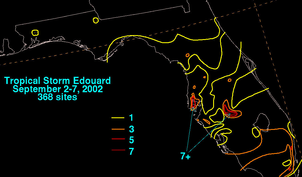
Tropical Storm Edouard dropped moderate rainfall across Florida, peaking at over 7 inches (175 mm) in the western portion of the state. Though it was a tropical storm at landfall, winds were light across the path of the storm over land. Several roads were flooded from moderate precipitation. No casualties were reported, and damage was minimal.
on August 25, likely in association with a low-level disturbance that formed along a cold front
. For several days, it moved southwestward, and, while located on the southwestern end of an upper-level trough
to the north of Puerto Rico
, deep convection throughout the system increased. The system tracked westward, and initially remained disorganized while surface pressures remained high. The system turned to a northwest drift, and began to slowly organize on August 30 while located a few hundred miles northeast of the Bahamas. A broad low pressure area
developed on August 31 though convection remained disorganized as winds of 20 to 25 mph (32 to 40 km/h) were reported in squalls. Conditions remained favorable for continued organization, and convection increased and persisted across the system. The system developed into Tropical Depression Five on September 1 after developing a low-level circulation while located about 140 miles (225 km) east of Daytona Beach, Florida
.
Upon first forming, the tropical depression was located in an area of light to moderate westerly wind shear
. With a ridge
to the north and west of the depression, the system moved to the northwest under weak steering currents. The depression slowly strengthened and intensified into Tropical Storm Edouard on September 2 while located about 120 miles (190 km) east of Jacksonville, Florida
. The storm remained disorganized with wind shear displacing most of the deep convection from the low-level circulation. Upon becoming a tropical storm, forecasters initially predicted Edouard to gradually turn to the northeast, and within three days be located a short distance off the coast of South Carolina
with winds of 60 mph (95 km/h). However, forecasters admitted little confidence in the prediction, and later forecasts predicted the storm to execute a loop and track westward into northern Florida or southern Georgia
. Shortly after the tropical cyclogenesis
of Edouard, steering currents became weak, resulting in the storm to turn sharply eastward. Late on September 2 deep convection developed over the center, though the center quickly became exposed again. The environment appeared to become more hostile on September 2 and 3 with increasing shear and dry air overspreading the center. Despite the conditions, the storm maintained vigorous convection over the eastern portion of the circulation, and it quickly intensified on September 3 to reach peak winds of 55 mph (90 km/h). A Reconnaissance Aircraft
flight into the system estimated surface winds of up to 60 mph (95 km/h) and reported flight level winds of 82 mph (132 km/h).
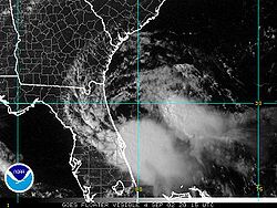
.jpg) Shortly after peaking in intensity, Tropical Storm Edouard began to weaken as convection diminished from vertical shear and dry air, and later on September 3 the center was exposed from the steadily decreasing convection. The development of a weak and narrow mid-level ridge turned the storm to the west-southwest towards northeastern Florida. Despite strong levels of wind shear, Edouard remained a tropical storm while producing sporadic amounts of deep convection, and on September 4 the banding structure improved. Early on September 5, Edouard made landfall near Ormond Beach, Florida
Shortly after peaking in intensity, Tropical Storm Edouard began to weaken as convection diminished from vertical shear and dry air, and later on September 3 the center was exposed from the steadily decreasing convection. The development of a weak and narrow mid-level ridge turned the storm to the west-southwest towards northeastern Florida. Despite strong levels of wind shear, Edouard remained a tropical storm while producing sporadic amounts of deep convection, and on September 4 the banding structure improved. Early on September 5, Edouard made landfall near Ormond Beach, Florida
as a minimal tropical storm, and almost immediately weakened to a tropical depression over land. It tracked across the state for about 13 hours and entered the Gulf of Mexico
near Crystal River
. Initial forecasts predicted Edouard to restrengthen to a tropical storm over the northeastern Gulf of Mexico, though uncertainty was noted due to the development of Tropical Storm Fay
in the northwestern portion of the gulf. Upon entering the Gulf of Mexico, the depression encountered strong wind shear from the outflow of Tropical Storm Fay. Edouard generated minimal amounts of intermittent convection along the southeastern portion of its circulation, enough for it to remain a tropical cyclone
. By September 6 the remaining convection dissipated, and Edouard dissipated while becoming absorbed into the larger circulation of Tropical Storm Fay.
 Three hours after developing, the National Hurricane Center
issued a tropical storm watch
from Titusville, Florida
to Brunswick, Georgia
due to uncertainty in the track of the storm. Hours after becoming a tropical storm, a tropical storm warning was issued from Fernandina Beach, Florida
to the mouth of the Savannah River
, with a tropical storm watch further northward to the mouth of the South Santee River
in South Carolina
, though these were cancelled after Edouard turned to the east. About 10 hours before landfall, the National Hurricane Center issued another tropical storm warning from Titusville, Florida to Brunswick, Georgia, with a tropical storm watch further south to Sebastian Inlet, Florida
.
Two days before the storm made landfall, several Florida counties were monitoring the progress of the storm. Though no serious impact was anticipated, Brevard County
officials identified possible shelters if warranted. Putnam County
officials placed several shelters on standby, and utility crews in Duval County
were placed on standby in the event of power failure. Several media releases of information were issued regarding the storm. The State Emergency Operation Center was on Level 2, or partial activation, and the state government organized two conferences to discuss county actions in regards to the storm. The National Weather Service
issued a flood watch
hours before Edouard made landfall for much of eastern Florida due to the expected rainfall from the storm.
The South Carolina
Emergency Management Division monitored the progress of the storm, and the Division increased its awareness level in response to the storm. Important state agencies in South Carolina government were notified to be ready to respond if the need arose.
 In Bermuda
, the outflow from the storm produced cloudy conditions throughout the island. Squally conditions were reported a short distance to the west of the island, though no rain was reported on Bermuda.
While moving erratically off the east coast of Florida, Tropical Storm Edouard produced rough surf conditions and rip currents along many beaches. Beachgoers and visitors were advised to exercise extreme caution. The storm produced water levels about 6 inches above normal near Cape Canaveral
, though elsewhere wave action and storm tides were not significant. Despite being a tropical storm at landfall, sustained tropical storm force winds were not observed. A rainband
ahead of the storm produced a 39 mph (63 km/h) wind gust at Patrick Air Force Base
, and a station in Saint Augustine recorded a wind gust of 38 mph (61 km/h). Sustained winds peaked at 31 mph (50 km/h) at Patrick Air Force Base. Edouard dropped light to moderate rainfall in eastern Florida, primarily during 2 to 3 hour periods. The highest official rainfall total peaked at 2.5 inches (64 mm) at Orlando Executive Airport
, though unofficial totals reached as high as 4.8 inches (122 mm) in Rockledge
. Rainfall was higher in western Florida, peaking at 7.64 inches (194 mm) in DeSoto County
with an area near Tampa
reporting over 7 inches (175 mm).
Moderate rainfall resulted in river flooding along the Saint Johns River, resulting in flooding along roads in Seminole County
. Roadway, urban, and lowland flooding was also reported in Brevard
and Orange counties
. Roadway flooding was extensive in some areas, resulting in road closures in Oviedo
, Cocoa Beach
, and Cape Canaveral. Heavy rainfall in Pinellas Park
caused heavy street flooding along an intersection on U.S. Highway 19. No casualties were reported, and damage was minor.
Tropical cyclone
A tropical cyclone is a storm system characterized by a large low-pressure center and numerous thunderstorms that produce strong winds and heavy rain. Tropical cyclones strengthen when water evaporated from the ocean is released as the saturated air rises, resulting in condensation of water vapor...
s to develop in September 2002, at the time the highest on record for any month. The fifth tropical storm of the 2002 Atlantic hurricane season
2002 Atlantic hurricane season
The 2002 Atlantic hurricane season was an average Atlantic hurricane season, officially starting on June 1, 2002 and ending on November 30, dates which conventionally limit the period of each year when tropical cyclones in the Atlantic Ocean tend to form...
, Edouard developed into a tropical cyclone on September 1 from an area of convection in association with a cold front
Surface weather analysis
Surface weather analysis is a special type of weather map that provides a view of weather elements over a geographical area at a specified time based on information from ground-based weather stations...
to the east of Florida
Florida
Florida is a state in the southeastern United States, located on the nation's Atlantic and Gulf coasts. It is bordered to the west by the Gulf of Mexico, to the north by Alabama and Georgia and to the east by the Atlantic Ocean. With a population of 18,801,310 as measured by the 2010 census, it...
. Under weak steering currents, Edouard drifted to the north and executed a clockwise loop to the west. Despite moderate to strong levels of wind shear
Wind shear
Wind shear, sometimes referred to as windshear or wind gradient, is a difference in wind speed and direction over a relatively short distance in the atmosphere...
, the storm reached a peak intensity of 65 mph (100 km/h) on September 3, though quickly weakened as it tracked westward. Edouard made landfall
Landfall (meteorology)
Landfall is the event of a tropical cyclone or a waterspout coming onto land after being over water. When a waterspout makes landfall it is reclassified as a tornado, which can then cause damage inland...
on northeastern Florida on September 5, and after crossing the state it dissipated on September 6 while being absorbed into the larger circulation of Tropical Storm Fay
Tropical Storm Fay (2002)
Tropical Storm Fay was the sixth named storm of the 2002 Atlantic hurricane season; it was a moderate tropical storm which caused flooding in parts of Texas and Mexico. In early September, a trough of low pressure moved south into the Gulf of Mexico, and became stationary...
.
Tropical Storm Edouard dropped moderate rainfall across Florida, peaking at over 7 inches (175 mm) in the western portion of the state. Though it was a tropical storm at landfall, winds were light across the path of the storm over land. Several roads were flooded from moderate precipitation. No casualties were reported, and damage was minimal.
Meteorological history
An area of cloudiness and rainshowers developed several hundred miles east-southeast of BermudaBermuda
Bermuda is a British overseas territory in the North Atlantic Ocean. Located off the east coast of the United States, its nearest landmass is Cape Hatteras, North Carolina, about to the west-northwest. It is about south of Halifax, Nova Scotia, Canada, and northeast of Miami, Florida...
on August 25, likely in association with a low-level disturbance that formed along a cold front
Surface weather analysis
Surface weather analysis is a special type of weather map that provides a view of weather elements over a geographical area at a specified time based on information from ground-based weather stations...
. For several days, it moved southwestward, and, while located on the southwestern end of an upper-level trough
Trough (meteorology)
A trough is an elongated region of relatively low atmospheric pressure, often associated with fronts.Unlike fronts, there is not a universal symbol for a trough on a weather chart. The weather charts in some countries or regions mark troughs by a line. In the United States, a trough may be marked...
to the north of Puerto Rico
Puerto Rico
Puerto Rico , officially the Commonwealth of Puerto Rico , is an unincorporated territory of the United States, located in the northeastern Caribbean, east of the Dominican Republic and west of both the United States Virgin Islands and the British Virgin Islands.Puerto Rico comprises an...
, deep convection throughout the system increased. The system tracked westward, and initially remained disorganized while surface pressures remained high. The system turned to a northwest drift, and began to slowly organize on August 30 while located a few hundred miles northeast of the Bahamas. A broad low pressure area
Low pressure area
A low-pressure area, or "low", is a region where the atmospheric pressure at sea level is below that of surrounding locations. Low-pressure systems form under areas of wind divergence which occur in upper levels of the troposphere. The formation process of a low-pressure area is known as...
developed on August 31 though convection remained disorganized as winds of 20 to 25 mph (32 to 40 km/h) were reported in squalls. Conditions remained favorable for continued organization, and convection increased and persisted across the system. The system developed into Tropical Depression Five on September 1 after developing a low-level circulation while located about 140 miles (225 km) east of Daytona Beach, Florida
Daytona Beach, Florida
Daytona Beach is a city in Volusia County, Florida, USA. According to 2008 U.S. Census Bureau estimates, the city has a population of 64,211. Daytona Beach is a principal city of the Deltona – Daytona Beach – Ormond Beach, Florida Metropolitan Statistical Area, which the census bureau estimated had...
.
Upon first forming, the tropical depression was located in an area of light to moderate westerly wind shear
Wind shear
Wind shear, sometimes referred to as windshear or wind gradient, is a difference in wind speed and direction over a relatively short distance in the atmosphere...
. With a ridge
Ridge (meteorology)
A ridge is an elongated region of relatively high atmospheric pressure, the opposite of a trough....
to the north and west of the depression, the system moved to the northwest under weak steering currents. The depression slowly strengthened and intensified into Tropical Storm Edouard on September 2 while located about 120 miles (190 km) east of Jacksonville, Florida
Jacksonville, Florida
Jacksonville is the largest city in the U.S. state of Florida in terms of both population and land area, and the largest city by area in the contiguous United States. It is the county seat of Duval County, with which the city government consolidated in 1968...
. The storm remained disorganized with wind shear displacing most of the deep convection from the low-level circulation. Upon becoming a tropical storm, forecasters initially predicted Edouard to gradually turn to the northeast, and within three days be located a short distance off the coast of South Carolina
South Carolina
South Carolina is a state in the Deep South of the United States that borders Georgia to the south, North Carolina to the north, and the Atlantic Ocean to the east. Originally part of the Province of Carolina, the Province of South Carolina was one of the 13 colonies that declared independence...
with winds of 60 mph (95 km/h). However, forecasters admitted little confidence in the prediction, and later forecasts predicted the storm to execute a loop and track westward into northern Florida or southern Georgia
Georgia (U.S. state)
Georgia is a state located in the southeastern United States. It was established in 1732, the last of the original Thirteen Colonies. The state is named after King George II of Great Britain. Georgia was the fourth state to ratify the United States Constitution, on January 2, 1788...
. Shortly after the tropical cyclogenesis
Tropical cyclogenesis
Tropical cyclogenesis is the term that describes the development and strengthening of a tropical cyclone in the atmosphere. The mechanisms through which tropical cyclogenesis occurs are distinctly different from those through which mid-latitude cyclogenesis occurs...
of Edouard, steering currents became weak, resulting in the storm to turn sharply eastward. Late on September 2 deep convection developed over the center, though the center quickly became exposed again. The environment appeared to become more hostile on September 2 and 3 with increasing shear and dry air overspreading the center. Despite the conditions, the storm maintained vigorous convection over the eastern portion of the circulation, and it quickly intensified on September 3 to reach peak winds of 55 mph (90 km/h). A Reconnaissance Aircraft
Hurricane Hunters
The Hurricane Hunters are aircraft that fly into tropical cyclones in the North Atlantic Ocean and Northeastern Pacific Ocean for the specific purpose of directly measuring weather data in and around those storms. In the United States, the Air Force, Navy, and NOAA units have all participated in...
flight into the system estimated surface winds of up to 60 mph (95 km/h) and reported flight level winds of 82 mph (132 km/h).
Ormond Beach, Florida
Ormond Beach is a city in Volusia County, Florida, United States. The population was 36,301 at the 2000 census. As of 2004, the population recorded by the U.S. Census Bureau is 37,929. Ormond Beach is the northern neighbor of Daytona Beach and is home to Tomoka State Park.-History:Ormond Beach was...
as a minimal tropical storm, and almost immediately weakened to a tropical depression over land. It tracked across the state for about 13 hours and entered the Gulf of Mexico
Gulf of Mexico
The Gulf of Mexico is a partially landlocked ocean basin largely surrounded by the North American continent and the island of Cuba. It is bounded on the northeast, north and northwest by the Gulf Coast of the United States, on the southwest and south by Mexico, and on the southeast by Cuba. In...
near Crystal River
Crystal River, Florida
Crystal River is a city in Citrus County, Florida, United States. The population was 3,485 at the 2000 census. . According to the U.S Census estimates of 2005, the city had a population of 3,539. The city was incorporated in 1903 and is the self professed "Home of the Manatee"....
. Initial forecasts predicted Edouard to restrengthen to a tropical storm over the northeastern Gulf of Mexico, though uncertainty was noted due to the development of Tropical Storm Fay
Tropical Storm Fay (2002)
Tropical Storm Fay was the sixth named storm of the 2002 Atlantic hurricane season; it was a moderate tropical storm which caused flooding in parts of Texas and Mexico. In early September, a trough of low pressure moved south into the Gulf of Mexico, and became stationary...
in the northwestern portion of the gulf. Upon entering the Gulf of Mexico, the depression encountered strong wind shear from the outflow of Tropical Storm Fay. Edouard generated minimal amounts of intermittent convection along the southeastern portion of its circulation, enough for it to remain a tropical cyclone
Tropical cyclone
A tropical cyclone is a storm system characterized by a large low-pressure center and numerous thunderstorms that produce strong winds and heavy rain. Tropical cyclones strengthen when water evaporated from the ocean is released as the saturated air rises, resulting in condensation of water vapor...
. By September 6 the remaining convection dissipated, and Edouard dissipated while becoming absorbed into the larger circulation of Tropical Storm Fay.
Preparations
National Hurricane Center
The National Hurricane Center , located at Florida International University in Miami, Florida, is the division of the National Weather Service responsible for tracking and predicting weather systems within the tropics between the Prime Meridian and the 140th meridian west poleward to the 30th...
issued a tropical storm watch
Tropical cyclone warnings and watches
Warnings and watches are two levels of alert issued by national weather forecasting bodies to coastal areas threatened by the imminent approach of a tropical cyclone of tropical storm or hurricane intensity. They are notices to the local population and civil authorities to make appropriate...
from Titusville, Florida
Titusville, Florida
Titusville is a city in Brevard County, Florida in the United States. It is the county seat of Brevard County. Nicknamed Space City, USA, Titusville is on the Indian River, west of Merritt Island and the Kennedy Space Center and south-southwest of the Canaveral National Seashore...
to Brunswick, Georgia
Brunswick, Georgia
Brunswick is the major urban and economic center in southeastern Georgia in the United States. The municipality is located on a harbor near the Atlantic Ocean, approximately 30 miles north of Florida and 70 miles south of South Carolina. Brunswick is bordered on the east by the Atlantic...
due to uncertainty in the track of the storm. Hours after becoming a tropical storm, a tropical storm warning was issued from Fernandina Beach, Florida
Fernandina Beach, Florida
Fernandina Beach is a city in Nassau County in the state of Florida in the United States of America and on Amelia Island. It is a part of Greater Jacksonville and is among Florida's northernmost cities. The area was first inhabited by the Timucuan Indian tribe...
to the mouth of the Savannah River
Savannah River
The Savannah River is a major river in the southeastern United States, forming most of the border between the states of South Carolina and Georgia. Two tributaries of the Savannah, the Tugaloo River and the Chattooga River, form the northernmost part of the border...
, with a tropical storm watch further northward to the mouth of the South Santee River
Santee River
The Santee River is a river in South Carolina in the United States, long. The Santee and its tributaries provide the principal drainage and navigation for the central coastal plain of South Carolina, emptying into the Atlantic Ocean approximately from its farthest headwater on the Catawba River...
in South Carolina
South Carolina
South Carolina is a state in the Deep South of the United States that borders Georgia to the south, North Carolina to the north, and the Atlantic Ocean to the east. Originally part of the Province of Carolina, the Province of South Carolina was one of the 13 colonies that declared independence...
, though these were cancelled after Edouard turned to the east. About 10 hours before landfall, the National Hurricane Center issued another tropical storm warning from Titusville, Florida to Brunswick, Georgia, with a tropical storm watch further south to Sebastian Inlet, Florida
Sebastian Inlet, Florida
Sebastian Inlet, located in Sebastian Inlet State Park in Brevard County, Florida and Indian River County, Florida, offers surfing and fishing opportunities. It is off Florida State Road A1A just 12 miles north of Vero Beach. There are annual surf tournaments, professional and amateur...
.
Two days before the storm made landfall, several Florida counties were monitoring the progress of the storm. Though no serious impact was anticipated, Brevard County
Brevard County, Florida
Brevard County is a county located in the U.S. state of Florida, along the coast of the Atlantic Ocean. As of 2007 U.S. Census Bureau estimates, the population is 536,521, making it the 10th most populous county in the state. Influenced by the presence of the John F. Kennedy Space Center, Brevard...
officials identified possible shelters if warranted. Putnam County
Putnam County, Florida
Putnam County is a county located in the state of Florida. The entire county makes up the Palatka Micropolitan Statistical Area. As of 2000, the population was 70,423. The U.S. Census Bureau 2009 estimate for the county was 72,893 . Its county seat is Palatka, Florida. The county is centrally...
officials placed several shelters on standby, and utility crews in Duval County
Duval County, Florida
Duval County is a county located in the U.S. state of Florida. As of 2010, the population was 864,263. Its county seat is Jacksonville, with which the Duval County government has been consolidated since 1968...
were placed on standby in the event of power failure. Several media releases of information were issued regarding the storm. The State Emergency Operation Center was on Level 2, or partial activation, and the state government organized two conferences to discuss county actions in regards to the storm. The National Weather Service
National Weather Service
The National Weather Service , once known as the Weather Bureau, is one of the six scientific agencies that make up the National Oceanic and Atmospheric Administration of the United States government...
issued a flood watch
Flood watch
Flood alerts are issued by weather agencies to alert residents that flood conditions are a possibility for their area.-Types of flood alerts:...
hours before Edouard made landfall for much of eastern Florida due to the expected rainfall from the storm.
The South Carolina
South Carolina
South Carolina is a state in the Deep South of the United States that borders Georgia to the south, North Carolina to the north, and the Atlantic Ocean to the east. Originally part of the Province of Carolina, the Province of South Carolina was one of the 13 colonies that declared independence...
Emergency Management Division monitored the progress of the storm, and the Division increased its awareness level in response to the storm. Important state agencies in South Carolina government were notified to be ready to respond if the need arose.
Impact
Bermuda
Bermuda is a British overseas territory in the North Atlantic Ocean. Located off the east coast of the United States, its nearest landmass is Cape Hatteras, North Carolina, about to the west-northwest. It is about south of Halifax, Nova Scotia, Canada, and northeast of Miami, Florida...
, the outflow from the storm produced cloudy conditions throughout the island. Squally conditions were reported a short distance to the west of the island, though no rain was reported on Bermuda.
While moving erratically off the east coast of Florida, Tropical Storm Edouard produced rough surf conditions and rip currents along many beaches. Beachgoers and visitors were advised to exercise extreme caution. The storm produced water levels about 6 inches above normal near Cape Canaveral
Cape Canaveral
Cape Canaveral, from the Spanish Cabo Cañaveral, is a headland in Brevard County, Florida, United States, near the center of the state's Atlantic coast. Known as Cape Kennedy from 1963 to 1973, it lies east of Merritt Island, separated from it by the Banana River.It is part of a region known as the...
, though elsewhere wave action and storm tides were not significant. Despite being a tropical storm at landfall, sustained tropical storm force winds were not observed. A rainband
Rainband
A rainband is a cloud and precipitation structure associated with an area of rainfall which is significantly elongated. Rainbands can be stratiform or convective, and are generated by differences in temperature. When noted on weather radar imagery, this precipitation elongation is referred to as...
ahead of the storm produced a 39 mph (63 km/h) wind gust at Patrick Air Force Base
Patrick Air Force Base
Patrick Air Force Base is a United States Air Force Base located between Satellite Beach and Cocoa Beach, in Brevard County, Florida, United States. It was named in honor of Major General Mason Patrick. An Air Force Space Command base, it is home to the 45th Space Wing...
, and a station in Saint Augustine recorded a wind gust of 38 mph (61 km/h). Sustained winds peaked at 31 mph (50 km/h) at Patrick Air Force Base. Edouard dropped light to moderate rainfall in eastern Florida, primarily during 2 to 3 hour periods. The highest official rainfall total peaked at 2.5 inches (64 mm) at Orlando Executive Airport
Orlando Executive Airport
Orlando Executive Airport is a public-use airport located three nautical miles east of the central business district of Orlando, a city in Orange County, Florida, United States. It is owned by the Greater Orlando Aviation Authority...
, though unofficial totals reached as high as 4.8 inches (122 mm) in Rockledge
Rockledge, Florida
Rockledge is the oldest city in Brevard County, Florida, United States. The population was 20,170 at the 2000 census. As of 2008, the estimated population according to the U.S. Census Bureau is 24,747. It is part of the Palm Bay–Melbourne–Titusville Metropolitan Statistical...
. Rainfall was higher in western Florida, peaking at 7.64 inches (194 mm) in DeSoto County
DeSoto County, Florida
DeSoto County is a county located in the U.S. state of Florida. As of 2000, the population was 32,209. The U.S. Census Bureau 2005 estimate for the county is 35,406 . Its county seat is Arcadia, Florida. The county comprises the Arcadia, Florida Micropolitan Statistical Area.- History :DeSoto...
with an area near Tampa
Tampa, Florida
Tampa is a city in the U.S. state of Florida. It serves as the county seat for Hillsborough County. Tampa is located on the west coast of Florida. The population of Tampa in 2010 was 335,709....
reporting over 7 inches (175 mm).
Moderate rainfall resulted in river flooding along the Saint Johns River, resulting in flooding along roads in Seminole County
Seminole County, Florida
Seminole County is a county in the U.S. state of Florida. Located between Orlando to the south and Deland and Daytona Beach to the north, it is part of the Greater Orlando metropolitan area. Its county seat and largest city is Sanford...
. Roadway, urban, and lowland flooding was also reported in Brevard
Brevard County, Florida
Brevard County is a county located in the U.S. state of Florida, along the coast of the Atlantic Ocean. As of 2007 U.S. Census Bureau estimates, the population is 536,521, making it the 10th most populous county in the state. Influenced by the presence of the John F. Kennedy Space Center, Brevard...
and Orange counties
Orange County, Florida
Orange County is a county located in the U.S. state of Florida and is part of the Orlando-Kissimmee-Sanford Metropolitan Statistical Area . As of 2010 U.S. Census, the county had a population of 1,145,956....
. Roadway flooding was extensive in some areas, resulting in road closures in Oviedo
Oviedo, Florida
Oviedo is a city in Seminole County, Florida, United States. The population was 26,316 as of the 2000 census. As of 2009, the population recorded by the U.S. Census Bureau is 32,961...
, Cocoa Beach
Cocoa Beach, Florida
Cocoa Beach is a city in Brevard County, Florida, United States. The population was 12,482 at the 2000 census. According to the U.S. Census Bureau estimates of 2008, the city had a population of 11,920...
, and Cape Canaveral. Heavy rainfall in Pinellas Park
Pinellas Park, Florida
Pinellas Park is a city located in central Pinellas County, Florida. The population was 45,658 at the 2000 census. As of 2004, the population estimated by the U.S. Census Bureau is 47,166 . The city was founded by Philadelphia publisher, F. A...
caused heavy street flooding along an intersection on U.S. Highway 19. No casualties were reported, and damage was minor.
See also
- List of Florida hurricanes (2000-present)
- Other storms of the same nameHurricane EdouardThe name Edouard has been used for five tropical cyclones in the Atlantic Ocean.* 1984's Tropical Storm Edouard - rapidly formed and strengthened in the Bay of Campeche, then degenerated just as quickly, causing no damage....