
.gif)
Tropical Storm Tammy (2005)
Encyclopedia
Tropical Storm Tammy was a short lived tropical storm during October in the 2005 Atlantic hurricane season
which caused minor damage to the southeastern United States. More significant, however were its remnants which contributed to the Northeast U.S. flooding of October 2005
.
Tropical Storm Tammy formed from a non-tropical system off the Florida
coast on October 5. It moved north just offshore before making landfall
later that day. The tropical storm rapidly weakened as it moved overland and dissipated the next day. Its remnant circulation moved south towards the Gulf of Mexico
, while the moisture was absorbed by a northeasterly moving cold front
. There were no fatalities directly related to Tammy; however, ten people were killed by the remnants of the storm in combination with the remnants of Subtropical Depression Twenty-Two. Total damages from the storm were $30 million.
left the western coast of Africa on September 24 and crossed the Atlantic without any development. The wave began to develop on October 2 north of the Lesser Antilles
when it encountered an upper level trough. It strengthened as it passed through the Bahamas and early on October 5 a vigorous tropical disturbance formed. As the system already had tropical-storm force winds, it was immediately named Tropical Storm Tammy. Upon being classified, the system was poorly organized, with deep convection
only persisting to the northeast of the center of circulation
. Tropical storm-force winds were presumed to be located underneath the convection as ship reports nearby the system only reported winds up to 35 mph (55 km/h). Tammy quickly tracked towards the northwest in a southerly flow between a mid to upper-level low
over the Gulf of Mexico
and a ridge
located over the western Atlantic Ocean. Later that day, a reconnaissance flight into the storm recorded flight level winds of 61 mph (98 km/h), which corresponds to surface winds of 50 mph (85 km/h). However, small areas of 60 mph (95 km/h) to 65 mph (100 km/h) were reported by the crew members of the aircraft. At 6:30 pm EST (2300 UTC), the storm made landfall with winds of 50 mph (85 km/h) near Atlantic Beach, Florida
. The tropical storm then moved inland over Georgia
and into southeastern Alabama
near Ozark, where it lost its circulation on October 6.
The remnant low drifted south towards the Gulf of Mexico
before being absorbed by a cold front
(which also picked remnants of Subtropical Depression Twenty-two), and moving northeast. This cold front, of which Tammy's remnants were a part, affected much of the Northeastern United States
over the next few days.
 Tropical Storm Tammy surprised forecasters when it formed on October 5. Because they had not expected the disturbance to develop, warnings were not issued until about 12 hours before the storm made landfall. Despite the short warning, tourists and business travelers cancelled flights as the storm neared landfall. Upon the storm developing, a tropical storm warning
was immediately issued for the coast from Cocoa Beach, Florida
to the Santee River
, South Carolina
.
The U.S. Department of Homeland Security's U.S. Coast Guard, 7th District issued an advisory to mariners, warning them to prepare for the storm and avoid the ocean if possible. In Georgia
, the National Park Service
evacuated the residents of Cumberland Island
and closed the ferry which services it. The Glynn County Emergency Operations Agency monitored and prepared for Tropical Storm Tammy's landfall, however the poor warning hampered their efforts. Residents all over the state expressed frustration at the lack of time they had to prepare. When Tammy moved inland 12 hours later the southern end of the warning zone moved north to Altamaha Sound, Georgia
before all warnings were discontinued on October 6.
 Tropical Storm Tammy caused minor damage. Its highest sustained winds were 50 mi/h and its strongest recorded wind gust was 60 mi/h. The winds produced no significant damage, but did disrupt power to 16,500 utility customers and delayed the Trysail College Regatta. Lightning produced by a thunderstorm in Broward County, Florida
struck three teenagers during a football game in Coconut Creek
, killing one and injuring the other two.
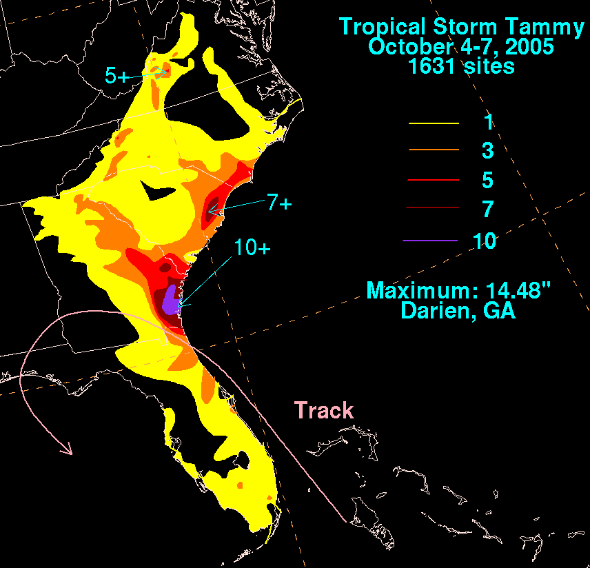
To most areas in north Florida and southern Georgia, Tammy brought 3 to 5 in (76.2 to 127 mm) of rain, though some isolated areas received 10 inches (254 mm). In Georgia, flooding damaged over 30 homes in Brunswick
. Several dirt and coastal roads were washed out, and sewers overflowed as far north as Baltimore County, Maryland
. Two small pond dams burst, including a 173-year-old wooden dam, but new stone dams were constructed in place before the old ones failed. Conversely, Tammy's rains were beneficial in South Carolina
, where they helped alleviate dry conditions after a rainless September.
Tammy's storm surge was approximately 2 to 4 ft (0.6096 to 1.2 m) and caused salt-water flooding along the coast of northeastern Florida, Georgia, and South Carolina
. The surge damages boardwalks along the coast, and wave action causes over 2 feet (0.6 m) of beach erosion. In addition to the flooding, Tropical Storm Tammy spawned one tornado. Rated an F0
tornado
, it touched down near Brunswick, Georgia
were it snapped trees and caused moderate roof damage along its 2 mi (3.2 km) path. The storm's total damage was estimated at around $30 million (2005 USD). The outer bands of Tammy brought heavy rains, peaking around 7 in (180 mm) in places, and caused significant beach erosion. Winds along the coastline gusted up to 59 mph (95 km/h), downing numerous trees. The worst damage occurred in Beaufort County
where 30 trees were downed, one of which fell on a home. Rough seas undermined several beach homes and caused one to be condemned.
which tracked north and contributed to the Northeast U.S. flooding of October 2005
, which killed ten people and caused significant damage. As a result of the flooding, the Federal Emergency Management Agency
paid $44 million in losses.
Shrimpers in the Carolinas blamed high fuel prices and the disruption of Tropical Storm Tammy for some of the troubles facing the shrimping industry in 2005. Rising fuel prices and dwindling demand has already created tough conditions that year, but the disruption of several days' fishing due to Tammy escalated the situation.
When Tropical Storm Tammy formed on October 5, it was the earliest ever in the season that the twentieth storm formed, beating the previous record held by Storm 20 of the 1933 season
by 21 days. Tammy was only the second Atlantic storm to be named with the letter 'T
', after Tanya
in 1995, until a third "T" named storm, Hurricane Tomas
, formed 5 years later in the
2010 Atlantic hurricane season
This was also the first time Tammy had been used to name any tropical cyclone worldwide. Due to the lack of any major effects from Tropical Storm Tammy, the name was not retired by the World Meteorological Organization
and will be on the list of names for the 2011 Season.
2005 Atlantic hurricane season
The 2005 Atlantic hurricane season was the most active Atlantic hurricane season in recorded history, repeatedly shattering numerous records. The impact of the season was widespread and ruinous with an estimated 3,913 deaths and record damage of about $159.2 billion...
which caused minor damage to the southeastern United States. More significant, however were its remnants which contributed to the Northeast U.S. flooding of October 2005
Northeast U.S. flooding of October 2005
In October 2005, remnants of Tropical Storm Tammy and Subtropical Depression Twenty-Two merged with incoming continental cold fronts to produce torrential rains over interior New England, as well as over parts of New Jersey and New York. Particularly hard hit was the state of New Hampshire, which...
.
Tropical Storm Tammy formed from a non-tropical system off the Florida
Florida
Florida is a state in the southeastern United States, located on the nation's Atlantic and Gulf coasts. It is bordered to the west by the Gulf of Mexico, to the north by Alabama and Georgia and to the east by the Atlantic Ocean. With a population of 18,801,310 as measured by the 2010 census, it...
coast on October 5. It moved north just offshore before making landfall
Landfall (meteorology)
Landfall is the event of a tropical cyclone or a waterspout coming onto land after being over water. When a waterspout makes landfall it is reclassified as a tornado, which can then cause damage inland...
later that day. The tropical storm rapidly weakened as it moved overland and dissipated the next day. Its remnant circulation moved south towards the Gulf of Mexico
Gulf of Mexico
The Gulf of Mexico is a partially landlocked ocean basin largely surrounded by the North American continent and the island of Cuba. It is bounded on the northeast, north and northwest by the Gulf Coast of the United States, on the southwest and south by Mexico, and on the southeast by Cuba. In...
, while the moisture was absorbed by a northeasterly moving cold front
Cold front
A cold front is defined as the leading edge of a cooler mass of air, replacing a warmer mass of air.-Development of cold front:The cooler and denser air wedges under the less-dense warmer air, lifting it...
. There were no fatalities directly related to Tammy; however, ten people were killed by the remnants of the storm in combination with the remnants of Subtropical Depression Twenty-Two. Total damages from the storm were $30 million.
Meteorological history
A tropical waveTropical wave
Tropical waves, easterly waves, or tropical easterly waves, also known as African easterly waves in the Atlantic region, are a type of atmospheric trough, an elongated area of relatively low air pressure, oriented north to south, which move from east to west across the tropics causing areas of...
left the western coast of Africa on September 24 and crossed the Atlantic without any development. The wave began to develop on October 2 north of the Lesser Antilles
Lesser Antilles
The Lesser Antilles are a long, partly volcanic island arc in the Western Hemisphere. Most of its islands form the eastern boundary of the Caribbean Sea with the Atlantic Ocean, with the remainder located in the southern Caribbean just north of South America...
when it encountered an upper level trough. It strengthened as it passed through the Bahamas and early on October 5 a vigorous tropical disturbance formed. As the system already had tropical-storm force winds, it was immediately named Tropical Storm Tammy. Upon being classified, the system was poorly organized, with deep convection
Atmospheric convection
Atmospheric convection is the result of a parcel-environment instability, or temperature difference, layer in the atmosphere. Different lapse rates within dry and moist air lead to instability. Mixing of air during the day which expands the height of the planetary boundary layer leads to...
only persisting to the northeast of the center of circulation
Eye (cyclone)
The eye is a region of mostly calm weather found at the center of strong tropical cyclones. The eye of a storm is a roughly circular area and typically 30–65 km in diameter. It is surrounded by the eyewall, a ring of towering thunderstorms where the second most severe weather of a cyclone...
. Tropical storm-force winds were presumed to be located underneath the convection as ship reports nearby the system only reported winds up to 35 mph (55 km/h). Tammy quickly tracked towards the northwest in a southerly flow between a mid to upper-level low
Low pressure area
A low-pressure area, or "low", is a region where the atmospheric pressure at sea level is below that of surrounding locations. Low-pressure systems form under areas of wind divergence which occur in upper levels of the troposphere. The formation process of a low-pressure area is known as...
over the Gulf of Mexico
Gulf of Mexico
The Gulf of Mexico is a partially landlocked ocean basin largely surrounded by the North American continent and the island of Cuba. It is bounded on the northeast, north and northwest by the Gulf Coast of the United States, on the southwest and south by Mexico, and on the southeast by Cuba. In...
and a ridge
High pressure area
A high-pressure area is a region where the atmospheric pressure at the surface of the planet is greater than its surrounding environment. Winds within high-pressure areas flow outward due to the higher density air near their center and friction with land...
located over the western Atlantic Ocean. Later that day, a reconnaissance flight into the storm recorded flight level winds of 61 mph (98 km/h), which corresponds to surface winds of 50 mph (85 km/h). However, small areas of 60 mph (95 km/h) to 65 mph (100 km/h) were reported by the crew members of the aircraft. At 6:30 pm EST (2300 UTC), the storm made landfall with winds of 50 mph (85 km/h) near Atlantic Beach, Florida
Atlantic Beach, Florida
Atlantic Beach, a city in Duval County, Florida, is the northernmost of the Jacksonville Beaches communities. When the majority of communities in Duval County consolidated with Jacksonville, Florida in 1968, Atlantic Beach, along with Jacksonville Beach, Neptune Beach, and Baldwin, Florida,...
. The tropical storm then moved inland over Georgia
Georgia (U.S. state)
Georgia is a state located in the southeastern United States. It was established in 1732, the last of the original Thirteen Colonies. The state is named after King George II of Great Britain. Georgia was the fourth state to ratify the United States Constitution, on January 2, 1788...
and into southeastern Alabama
Alabama
Alabama is a state located in the southeastern region of the United States. It is bordered by Tennessee to the north, Georgia to the east, Florida and the Gulf of Mexico to the south, and Mississippi to the west. Alabama ranks 30th in total land area and ranks second in the size of its inland...
near Ozark, where it lost its circulation on October 6.
The remnant low drifted south towards the Gulf of Mexico
Gulf of Mexico
The Gulf of Mexico is a partially landlocked ocean basin largely surrounded by the North American continent and the island of Cuba. It is bounded on the northeast, north and northwest by the Gulf Coast of the United States, on the southwest and south by Mexico, and on the southeast by Cuba. In...
before being absorbed by a cold front
Cold front
A cold front is defined as the leading edge of a cooler mass of air, replacing a warmer mass of air.-Development of cold front:The cooler and denser air wedges under the less-dense warmer air, lifting it...
(which also picked remnants of Subtropical Depression Twenty-two), and moving northeast. This cold front, of which Tammy's remnants were a part, affected much of the Northeastern United States
Northeastern United States
The Northeastern United States is a region of the United States as defined by the United States Census Bureau.-Composition:The region comprises nine states: the New England states of Connecticut, Maine, Massachusetts, New Hampshire, Rhode Island and Vermont; and the Mid-Atlantic states of New...
over the next few days.
Preparations
Tropical cyclone warnings and watches
Warnings and watches are two levels of alert issued by national weather forecasting bodies to coastal areas threatened by the imminent approach of a tropical cyclone of tropical storm or hurricane intensity. They are notices to the local population and civil authorities to make appropriate...
was immediately issued for the coast from Cocoa Beach, Florida
Cocoa Beach, Florida
Cocoa Beach is a city in Brevard County, Florida, United States. The population was 12,482 at the 2000 census. According to the U.S. Census Bureau estimates of 2008, the city had a population of 11,920...
to the Santee River
Santee River
The Santee River is a river in South Carolina in the United States, long. The Santee and its tributaries provide the principal drainage and navigation for the central coastal plain of South Carolina, emptying into the Atlantic Ocean approximately from its farthest headwater on the Catawba River...
, South Carolina
South Carolina
South Carolina is a state in the Deep South of the United States that borders Georgia to the south, North Carolina to the north, and the Atlantic Ocean to the east. Originally part of the Province of Carolina, the Province of South Carolina was one of the 13 colonies that declared independence...
.
The U.S. Department of Homeland Security's U.S. Coast Guard, 7th District issued an advisory to mariners, warning them to prepare for the storm and avoid the ocean if possible. In Georgia
Georgia (U.S. state)
Georgia is a state located in the southeastern United States. It was established in 1732, the last of the original Thirteen Colonies. The state is named after King George II of Great Britain. Georgia was the fourth state to ratify the United States Constitution, on January 2, 1788...
, the National Park Service
National Park Service
The National Park Service is the U.S. federal agency that manages all national parks, many national monuments, and other conservation and historical properties with various title designations...
evacuated the residents of Cumberland Island
Cumberland Island
Cumberland Island is one of the Sea Islands. Cumberland is the largest in terms of continuously exposed land area of Georgia's barrier islands. It is located on the Atlantic Ocean off the coast of the U.S. state of Georgia and is part of Camden County...
and closed the ferry which services it. The Glynn County Emergency Operations Agency monitored and prepared for Tropical Storm Tammy's landfall, however the poor warning hampered their efforts. Residents all over the state expressed frustration at the lack of time they had to prepare. When Tammy moved inland 12 hours later the southern end of the warning zone moved north to Altamaha Sound, Georgia
Georgia (U.S. state)
Georgia is a state located in the southeastern United States. It was established in 1732, the last of the original Thirteen Colonies. The state is named after King George II of Great Britain. Georgia was the fourth state to ratify the United States Constitution, on January 2, 1788...
before all warnings were discontinued on October 6.
Impact
Broward County, Florida
-2000 Census:As of the census of 2000, there were 1,623,018 people, 654,445 households, and 411,645 families residing in the county. The population density was 1,346 people per square mile . There were 741,043 housing units at an average density of 615 per square mile...
struck three teenagers during a football game in Coconut Creek
Coconut Creek, Florida
Coconut Creek is a city in Broward County, Florida , nestled between Miami-Dade and Palm Beach counties. It had a population of 52,909 at the 2010 census...
, killing one and injuring the other two.
To most areas in north Florida and southern Georgia, Tammy brought 3 to 5 in (76.2 to 127 mm) of rain, though some isolated areas received 10 inches (254 mm). In Georgia, flooding damaged over 30 homes in Brunswick
Brunswick, Georgia
Brunswick is the major urban and economic center in southeastern Georgia in the United States. The municipality is located on a harbor near the Atlantic Ocean, approximately 30 miles north of Florida and 70 miles south of South Carolina. Brunswick is bordered on the east by the Atlantic...
. Several dirt and coastal roads were washed out, and sewers overflowed as far north as Baltimore County, Maryland
Baltimore County, Maryland
Baltimore County is a county located in the northern part of the US state of Maryland. In 2010, its population was 805,029. It is part of the Baltimore-Washington Metropolitan Area. Its county seat is Towson. The name of the county was derived from the barony of the Proprietor of the Maryland...
. Two small pond dams burst, including a 173-year-old wooden dam, but new stone dams were constructed in place before the old ones failed. Conversely, Tammy's rains were beneficial in South Carolina
South Carolina
South Carolina is a state in the Deep South of the United States that borders Georgia to the south, North Carolina to the north, and the Atlantic Ocean to the east. Originally part of the Province of Carolina, the Province of South Carolina was one of the 13 colonies that declared independence...
, where they helped alleviate dry conditions after a rainless September.
Tammy's storm surge was approximately 2 to 4 ft (0.6096 to 1.2 m) and caused salt-water flooding along the coast of northeastern Florida, Georgia, and South Carolina
South Carolina
South Carolina is a state in the Deep South of the United States that borders Georgia to the south, North Carolina to the north, and the Atlantic Ocean to the east. Originally part of the Province of Carolina, the Province of South Carolina was one of the 13 colonies that declared independence...
. The surge damages boardwalks along the coast, and wave action causes over 2 feet (0.6 m) of beach erosion. In addition to the flooding, Tropical Storm Tammy spawned one tornado. Rated an F0
Fujita scale
The Fujita scale , or Fujita-Pearson scale, is a scale for rating tornado intensity, based primarily on the damage tornadoes inflict on human-built structures and vegetation...
tornado
Tornado
A tornado is a violent, dangerous, rotating column of air that is in contact with both the surface of the earth and a cumulonimbus cloud or, in rare cases, the base of a cumulus cloud. They are often referred to as a twister or a cyclone, although the word cyclone is used in meteorology in a wider...
, it touched down near Brunswick, Georgia
Brunswick, Georgia
Brunswick is the major urban and economic center in southeastern Georgia in the United States. The municipality is located on a harbor near the Atlantic Ocean, approximately 30 miles north of Florida and 70 miles south of South Carolina. Brunswick is bordered on the east by the Atlantic...
were it snapped trees and caused moderate roof damage along its 2 mi (3.2 km) path. The storm's total damage was estimated at around $30 million (2005 USD). The outer bands of Tammy brought heavy rains, peaking around 7 in (180 mm) in places, and caused significant beach erosion. Winds along the coastline gusted up to 59 mph (95 km/h), downing numerous trees. The worst damage occurred in Beaufort County
Beaufort County, South Carolina
-National protected areas:*Ernest F. Hollings ACE Basin National Wildlife Refuge *Pinckney Island National Wildlife Refuge-Demographics:As of the census of 2000, there were 155,215 people, 45,532 households, and 33,056 families residing in the county. The population density was 206 people per...
where 30 trees were downed, one of which fell on a home. Rough seas undermined several beach homes and caused one to be condemned.
Aftermath, naming and records
A Red Cross shelter at Seldon Park, Brunswick, Georgia, opened for two days following the storm to temporarily house those whose houses were flooded. Tammy's remnant low was absorbed a larger extratropical lowExtratropical cyclone
Extratropical cyclones, sometimes called mid-latitude cyclones or wave cyclones, are a group of cyclones defined as synoptic scale low pressure weather systems that occur in the middle latitudes of the Earth having neither tropical nor polar characteristics, and are connected with fronts and...
which tracked north and contributed to the Northeast U.S. flooding of October 2005
Northeast U.S. flooding of October 2005
In October 2005, remnants of Tropical Storm Tammy and Subtropical Depression Twenty-Two merged with incoming continental cold fronts to produce torrential rains over interior New England, as well as over parts of New Jersey and New York. Particularly hard hit was the state of New Hampshire, which...
, which killed ten people and caused significant damage. As a result of the flooding, the Federal Emergency Management Agency
Federal Emergency Management Agency
The Federal Emergency Management Agency is an agency of the United States Department of Homeland Security, initially created by Presidential Reorganization Plan No. 1 of 1978 and implemented by two Executive Orders...
paid $44 million in losses.
Shrimpers in the Carolinas blamed high fuel prices and the disruption of Tropical Storm Tammy for some of the troubles facing the shrimping industry in 2005. Rising fuel prices and dwindling demand has already created tough conditions that year, but the disruption of several days' fishing due to Tammy escalated the situation.
When Tropical Storm Tammy formed on October 5, it was the earliest ever in the season that the twentieth storm formed, beating the previous record held by Storm 20 of the 1933 season
1993 Atlantic hurricane season
The 1993 Atlantic hurricane season was a period in the annual formation of tropical cyclones. It officially began on June 1, 1993, and lasted until November 30, 1993. These dates conventionally delimit the period of each year when most tropical cyclones form in the Atlantic basin...
by 21 days. Tammy was only the second Atlantic storm to be named with the letter 'T
T
T is the 20th letter in the basic modern Latin alphabet. It is the most commonly used consonant and the second most common letter in the English language.- History :Taw was the last letter of the Western Semitic and Hebrew alphabets...
', after Tanya
Hurricane Tanya (1995)
Hurricane Tanya was the final storm of the very active 1995 Atlantic hurricane season. The twenty-first tropical cyclone, nineteenth named storm, and eleventh hurricane of the season, Tanya developed from a tropical wave while well north of the Lesser Antilles on October 26. The system headed...
in 1995, until a third "T" named storm, Hurricane Tomas
Hurricane Tomas
Hurricane Tomas was the nineteenth named storm and twelfth hurricane of the 2010 Atlantic hurricane season. Tomas developed from a tropical wave east of the Windward Islands on October 29. Quickly intensifying into a hurricane, it moved through the Windward Islands and passed very near Saint...
, formed 5 years later in the
2010 Atlantic hurricane season
2010 Atlantic hurricane season
The 2010 Atlantic hurricane season was the third most active Atlantic hurricane season on record, tying with the 1887 Atlantic hurricane season, 1995 Atlantic hurricane season and the 2011 Atlantic hurricane season. It had the most number of named storms since the 2005 season and also ties with the...
This was also the first time Tammy had been used to name any tropical cyclone worldwide. Due to the lack of any major effects from Tropical Storm Tammy, the name was not retired by the World Meteorological Organization
World Meteorological Organization
The World Meteorological Organization is an intergovernmental organization with a membership of 189 Member States and Territories. It originated from the International Meteorological Organization , which was founded in 1873...
and will be on the list of names for the 2011 Season.
See also
- List of 2005 Atlantic hurricane season storms
- Northeast Flooding of October 2005
- Timeline of the 2005 Atlantic hurricane seasonTimeline of the 2005 Atlantic hurricane seasonThe timeline of the 2005 Atlantic hurricane season documents the formations, strengthenings, weakenings, landfalls, extratropical transitions, and dissipations of the season's tropical and subtropical storms. The 2005 Atlantic hurricane season was the most active Atlantic hurricane season in...
- List of Florida hurricanes (2000–present)