
.gif)
Tropical Storm Helene (2000)
Encyclopedia
Tropical Storm Helene was a weak tropical cyclone
that made landfall
in the United States
as a minimal tropical storm. The tropical system was the twelfth tropical cyclone and eighth tropical storm of the 2000 Atlantic hurricane season
. After becoming a tropical depression east of the Windward Islands
on September 15, the system weakened and traveled across the Caribbean Sea
. Late on the 19th, it regained tropical depression status, and on the 21st, it reached tropical storm intensity, and received the name Helene
. At this point, Helene was located in the southeastern Gulf of Mexico
; from there, the storm turned north, and made landfall at Fort Walton Beach, Florida
, on September 22. The system weakened to a tropical depression over land, but it did not dissipate, eventually reemerging onto the Atlantic Ocean
over the North Carolina
coast. Helene regained tropical storm strength and headed rapidly east-northeast over open seas; on September 25, Helene merged with a cold front
, ending its life as a tropical cyclone.
One person was a direct casualty of Helene, after a tornado moved through South Carolina
; another was indirectly killed during a car accident in North Carolina. Flooding of up to 9 inches (229 mm) was reported in Tallahassee, Florida
; however, the maximum recorded precipitation from Helene was 10.32 inches (262 mm) in Apalachicola. Total damage was estimated at $16 million (2000 USD, $18.7 million 2006 USD). President Clinton
declared the state of Florida a major disaster area, therefore making nine counties eligible for federal disaster relief.
moved off the Africa
n coast on September 10. Shortly after, it lost most of its atmospheric convection, and showed little signs of redevelopment as it moved eastward. On September 14, convection reappeared near the center of the system. The next day, the National Hurricane Center
in Miami, Florida
designated the area of disturbed weather as Tropical Depression Twelve. At this point, the tropical depression was located 470 mi (765 km) east of the Leeward Islands
. However, before reconnaissance plane
s could fly to the system, it had already lost its closed circulation and degenerated back into a tropical wave. Though the area was favorable for redevelopment, the wave did very little while it traveled through the Caribbean Sea
. Late on September 19, another reconnaissance plane discovered a closed circulation just to the northwest of Grand Cayman
, so it was reclassidied as Tropical Depression Twelve. It managed to retain what little organization it had when it crossed the western tip of Cuba
on September 20. The next day, convection redeveloped and the tropical cyclone was upgraded to Tropical Storm Helene while in the southeastern Gulf of Mexico.
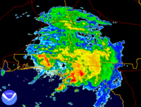 The storm turned north, while rapidly strengthening in marginally favorable conditions. Helene attained its maximum intensity of 70 mph (115 km/h) for the first time, as well as a minimum central pressure of 996 mbar, late on September 21 (CDT, early September 22 UTC). At that time, wind shear
increased, and prevented the tropical storm from reaching hurricane status. The storm lost most of its deep convection, and the heavy rainbands were displaced to the east of the center. Helene weakened even more quickly than it strengthened, going from a 70 mph (115 km/h) tropical storm to a 40 mph (65 km/h) tropical storm in just 12 hours. It made landfall at Fort Walton Beach, Florida
around 7 am CDT on September 22, only five days after Hurricane Gordon
struck the same general area. The system weakened to a tropical depression while moving northeast over the Southeastern United States
. The weakened system managed to not dissipate as it passed over North Carolina
, . Operationally, the storm was no longer considered a tropical cyclone and was treated as a low-pressure system
while passing over North Carolina. Once over the Atlantic, the NHC stated that advisories could be reinitiated because Helene was reacquiring tropical characteristics, but moved over colder waters before they could do so. It was later discovered to have remained tropical and have a closed circulation for far longer. Helene reentered the north Atlantic as a relatively compact storm. It moved away from the East Coast of the United States
and reached a peak intensity of 70 mph (115 km/h) and a minimum central pressure of 986 mbar. It merged with a cold front on September 25.
 Eighteen shelters, including two for people or families with special needs, were opened throughout Leon
, Jefferson
, Madison
, Taylor
, Wakulla, Liberty
, and Gadsen counties in the Florida Panhandle
. Flights were canceled at Tallahassee
's airport and state government offices in the capital city were closed. City buses stopped running during the storm but were back on schedule by early afternoon.
, while over 10 inches (254 mm) of rain swamped Apalachicola
. Six or more tornadoes touched down between the two cities, but caused no significant damage as they crossed sparsely populated land.
Six homes across Franklin
, Leon, and Wakulla counties in Florida were destroyed, while 17 suffered major damage, and another 65 had minor damage done to them. The Gulf County Division of Emergency Management estimated there was between $100,000 and $300,000 (2000 USD, $117,000 and $351,000 2006 USD) in road damage and beach erosion on the part of a peninsula called Cape San Blas
.
 An F2 tornado ripped through Martin, South Carolina
on September 23, directly killing a man in a trailer while he slept and injuring six others in adjacent homes. The highest rainfall measurement in South Carolina came from Bamberg
, at 9.6 inches (244 mm). Flash flooding also occurred in Aiken County
. Downed trees were blocking State Highway 125 in Allendale County
, and the county emergency management office reported major damage to five or six mobile homes. Reports from the local weather service say that State Highway 47 was flooded near Elgin
and too dangerous to drive on. The weather service also stated that Virginia Avenue was washed out in Barnwell
. An indirect fatality occurred from flood related traffic in Berkeley County
. A middle-aged woman lost control of her car when she hit a patch of water on the road and the car hit a pine tree.
The southbound lane of U.S. Highway 17 in North Carolina
flooded from heavy rain and traffic was detoured south of Shallotte
. There were also a few minor washouts on back roads and street flooding in towns.
Bill Clinton
declared the state a major disaster area. Therefore, the counties of Bay
, Calhoun
, Escambia
, Franklin, Gulf
, Jefferson, Leon, Okaloosa, and Wakulla that were affected by Helene were eligible for federal disaster funds. The federal funds are able to pay 75% of the approved cost for debris removal, emergency services related to the storm, and restoring damaged public facilities. As part of the disaster relief operation, clean-up kits were distributed to the flood victims. Bottled water was also delivered the victims of Helene in Franklin County. Five Family Service Outreach Teams were dispatched and were told to go door to door in Leon and Wakulla counties. A total of 700 meals were distributed to various victims of the storm.
Tropical cyclone
A tropical cyclone is a storm system characterized by a large low-pressure center and numerous thunderstorms that produce strong winds and heavy rain. Tropical cyclones strengthen when water evaporated from the ocean is released as the saturated air rises, resulting in condensation of water vapor...
that made landfall
Landfall (meteorology)
Landfall is the event of a tropical cyclone or a waterspout coming onto land after being over water. When a waterspout makes landfall it is reclassified as a tornado, which can then cause damage inland...
in the United States
United States
The United States of America is a federal constitutional republic comprising fifty states and a federal district...
as a minimal tropical storm. The tropical system was the twelfth tropical cyclone and eighth tropical storm of the 2000 Atlantic hurricane season
2000 Atlantic hurricane season
The 2000 Atlantic hurricane season was the first season without a tropical cyclone in July since 1987. The season officially began on June 1, 2000, and lasted until November 30, 2000. The June through November dates conventionally delimit the period of each year when most tropical cyclones form in...
. After becoming a tropical depression east of the Windward Islands
Windward Islands
The Windward Islands are the southern islands of the Lesser Antilles, within the West Indies.-Name and geography:The Windward Islands are called such because they were more windward to sailing ships arriving in the New World than the Leeward Islands, given that the prevailing trade winds in the...
on September 15, the system weakened and traveled across the Caribbean Sea
Caribbean Sea
The Caribbean Sea is a sea of the Atlantic Ocean located in the tropics of the Western hemisphere. It is bounded by Mexico and Central America to the west and southwest, to the north by the Greater Antilles, and to the east by the Lesser Antilles....
. Late on the 19th, it regained tropical depression status, and on the 21st, it reached tropical storm intensity, and received the name Helene
Helene
Helene may refer to:*Helene , a Greek feminine name*Helen of Troy*Helene, a figure in Greek mythology who was a friend of Aphrodite and helped her seduce Adonis....
. At this point, Helene was located in the southeastern Gulf of Mexico
Gulf of Mexico
The Gulf of Mexico is a partially landlocked ocean basin largely surrounded by the North American continent and the island of Cuba. It is bounded on the northeast, north and northwest by the Gulf Coast of the United States, on the southwest and south by Mexico, and on the southeast by Cuba. In...
; from there, the storm turned north, and made landfall at Fort Walton Beach, Florida
Fort Walton Beach, Florida
Fort Walton Beach is a city in southern Okaloosa County, Florida, United States. As of 2005, the population estimate for Fort Walton Beach was 19,992, and as of 2010, the population estimate for Fort Walton Beach is 19,507 recorded by the U.S. Census Bureau...
, on September 22. The system weakened to a tropical depression over land, but it did not dissipate, eventually reemerging onto the Atlantic Ocean
Atlantic Ocean
The Atlantic Ocean is the second-largest of the world's oceanic divisions. With a total area of about , it covers approximately 20% of the Earth's surface and about 26% of its water surface area...
over the North Carolina
North Carolina
North Carolina is a state located in the southeastern United States. The state borders South Carolina and Georgia to the south, Tennessee to the west and Virginia to the north. North Carolina contains 100 counties. Its capital is Raleigh, and its largest city is Charlotte...
coast. Helene regained tropical storm strength and headed rapidly east-northeast over open seas; on September 25, Helene merged with a cold front
Cold front
A cold front is defined as the leading edge of a cooler mass of air, replacing a warmer mass of air.-Development of cold front:The cooler and denser air wedges under the less-dense warmer air, lifting it...
, ending its life as a tropical cyclone.
One person was a direct casualty of Helene, after a tornado moved through South Carolina
South Carolina
South Carolina is a state in the Deep South of the United States that borders Georgia to the south, North Carolina to the north, and the Atlantic Ocean to the east. Originally part of the Province of Carolina, the Province of South Carolina was one of the 13 colonies that declared independence...
; another was indirectly killed during a car accident in North Carolina. Flooding of up to 9 inches (229 mm) was reported in Tallahassee, Florida
Tallahassee, Florida
Tallahassee is the capital of the U.S. state of Florida. It is the county seat and only incorporated municipality in Leon County, and is the 128th largest city in the United States. Tallahassee became the capital of Florida, then the Florida Territory, in 1824. In 2010, the population recorded by...
; however, the maximum recorded precipitation from Helene was 10.32 inches (262 mm) in Apalachicola. Total damage was estimated at $16 million (2000 USD, $18.7 million 2006 USD). President Clinton
Bill Clinton
William Jefferson "Bill" Clinton is an American politician who served as the 42nd President of the United States from 1993 to 2001. Inaugurated at age 46, he was the third-youngest president. He took office at the end of the Cold War, and was the first president of the baby boomer generation...
declared the state of Florida a major disaster area, therefore making nine counties eligible for federal disaster relief.
Meteorological history
A well-defined tropical waveTropical wave
Tropical waves, easterly waves, or tropical easterly waves, also known as African easterly waves in the Atlantic region, are a type of atmospheric trough, an elongated area of relatively low air pressure, oriented north to south, which move from east to west across the tropics causing areas of...
moved off the Africa
Africa
Africa is the world's second largest and second most populous continent, after Asia. At about 30.2 million km² including adjacent islands, it covers 6% of the Earth's total surface area and 20.4% of the total land area...
n coast on September 10. Shortly after, it lost most of its atmospheric convection, and showed little signs of redevelopment as it moved eastward. On September 14, convection reappeared near the center of the system. The next day, the National Hurricane Center
National Hurricane Center
The National Hurricane Center , located at Florida International University in Miami, Florida, is the division of the National Weather Service responsible for tracking and predicting weather systems within the tropics between the Prime Meridian and the 140th meridian west poleward to the 30th...
in Miami, Florida
Miami, Florida
Miami is a city located on the Atlantic coast in southeastern Florida and the county seat of Miami-Dade County, the most populous county in Florida and the eighth-most populous county in the United States with a population of 2,500,625...
designated the area of disturbed weather as Tropical Depression Twelve. At this point, the tropical depression was located 470 mi (765 km) east of the Leeward Islands
Leeward Islands
The Leeward Islands are a group of islands in the West Indies. They are the northern islands of the Lesser Antilles chain. As a group they start east of Puerto Rico and reach southward to Dominica. They are situated where the northeastern Caribbean Sea meets the western Atlantic Ocean...
. However, before reconnaissance plane
Surveillance aircraft
A surveillance aircraft is an aircraft used for surveillance — collecting information over time. They are operated by military forces and other government agencies in roles such as intelligence gathering, battlefield surveillance, airspace surveillance, observation , border patrol and fishery...
s could fly to the system, it had already lost its closed circulation and degenerated back into a tropical wave. Though the area was favorable for redevelopment, the wave did very little while it traveled through the Caribbean Sea
Caribbean Sea
The Caribbean Sea is a sea of the Atlantic Ocean located in the tropics of the Western hemisphere. It is bounded by Mexico and Central America to the west and southwest, to the north by the Greater Antilles, and to the east by the Lesser Antilles....
. Late on September 19, another reconnaissance plane discovered a closed circulation just to the northwest of Grand Cayman
Grand Cayman
Grand Cayman is the largest of the three Cayman Islands and the location of the nation's capital, George Town. In relation to the other two Cayman Islands, it is approximately 75 miles southwest of Little Cayman and 90 miles southwest of Cayman Brac.-Geography:Grand Cayman encompasses 76% of...
, so it was reclassidied as Tropical Depression Twelve. It managed to retain what little organization it had when it crossed the western tip of Cuba
Cuba
The Republic of Cuba is an island nation in the Caribbean. The nation of Cuba consists of the main island of Cuba, the Isla de la Juventud, and several archipelagos. Havana is the largest city in Cuba and the country's capital. Santiago de Cuba is the second largest city...
on September 20. The next day, convection redeveloped and the tropical cyclone was upgraded to Tropical Storm Helene while in the southeastern Gulf of Mexico.
Wind shear
Wind shear, sometimes referred to as windshear or wind gradient, is a difference in wind speed and direction over a relatively short distance in the atmosphere...
increased, and prevented the tropical storm from reaching hurricane status. The storm lost most of its deep convection, and the heavy rainbands were displaced to the east of the center. Helene weakened even more quickly than it strengthened, going from a 70 mph (115 km/h) tropical storm to a 40 mph (65 km/h) tropical storm in just 12 hours. It made landfall at Fort Walton Beach, Florida
Fort Walton Beach, Florida
Fort Walton Beach is a city in southern Okaloosa County, Florida, United States. As of 2005, the population estimate for Fort Walton Beach was 19,992, and as of 2010, the population estimate for Fort Walton Beach is 19,507 recorded by the U.S. Census Bureau...
around 7 am CDT on September 22, only five days after Hurricane Gordon
Hurricane Gordon (2000)
Hurricane Gordon was one of two U.S. landfalling tropical storms of the 2000 Atlantic hurricane season, and was the 7th named storm and 4th hurricane of the 2000 Atlantic hurricane season. Gordon was a category 1 hurricane over the Gulf of Mexico but weakened to a tropical storm before making...
struck the same general area.
Southeastern United States
The Southeastern United States, colloquially referred to as the Southeast, is the eastern portion of the Southern United States. It is one of the most populous regions in the United States of America....
. The weakened system managed to not dissipate as it passed over North Carolina
North Carolina
North Carolina is a state located in the southeastern United States. The state borders South Carolina and Georgia to the south, Tennessee to the west and Virginia to the north. North Carolina contains 100 counties. Its capital is Raleigh, and its largest city is Charlotte...
, . Operationally, the storm was no longer considered a tropical cyclone and was treated as a low-pressure system
while passing over North Carolina. Once over the Atlantic, the NHC stated that advisories could be reinitiated because Helene was reacquiring tropical characteristics, but moved over colder waters before they could do so. It was later discovered to have remained tropical and have a closed circulation for far longer. Helene reentered the north Atlantic as a relatively compact storm. It moved away from the East Coast of the United States
East Coast of the United States
The East Coast of the United States, also known as the Eastern Seaboard, refers to the easternmost coastal states in the United States, which touch the Atlantic Ocean and stretch up to Canada. The term includes the U.S...
and reached a peak intensity of 70 mph (115 km/h) and a minimum central pressure of 986 mbar. It merged with a cold front on September 25.
Preparations
Leon County, Florida
Leon County is a county located in the state of Florida, named after the Spanish explorer Juan Ponce de León. At the 2010 Census, the population was 275,487. The county seat of Leon County is Tallahassee which also serves as the state capital. The county seat is home to two of Florida's major...
, Jefferson
Jefferson County, Florida
Jefferson County is a county located in the U.S. state of Florida. As of 2000, the population is 12,902. The U.S. Census Bureau 2005 estimate for the county is 14,490 . Its county seat is Monticello, Florida....
, Madison
Madison County, Florida
Madison County is a county located in the state of Florida. As of 2000, the population was 18,733. The U.S. Census Bureau 2005 estimate for the county is 19,902. Its county seat is Madison, Florida. Madison County is one of Florida's five dry counties....
, Taylor
Taylor County, Florida
Taylor County is a county located in the state of Florida. As of 2000, the population was 19,256. The U.S. Census Bureau 2005 estimate for the county was 19,622 . Its county seat is Perry, Florida.- History :Taylor County was created in 1856...
, Wakulla, Liberty
Liberty County, Florida
Liberty County is a county located in the state of Florida. Its population was estimated in 2005 as 7,733. Its most populous incorporated area and county seat is Bristol....
, and Gadsen counties in the Florida Panhandle
Florida Panhandle
The Florida Panhandle, an informal, unofficial term for the northwestern part of Florida, is a strip of land roughly 200 miles long and 50 to 100 miles wide , lying between Alabama on the north and the west, Georgia also on the north, and the Gulf of Mexico to the south. Its eastern boundary is...
. Flights were canceled at Tallahassee
Tallahassee, Florida
Tallahassee is the capital of the U.S. state of Florida. It is the county seat and only incorporated municipality in Leon County, and is the 128th largest city in the United States. Tallahassee became the capital of Florida, then the Florida Territory, in 1824. In 2010, the population recorded by...
's airport and state government offices in the capital city were closed. City buses stopped running during the storm but were back on schedule by early afternoon.
Impact
Tropical Storm Helene caused $16 million (2000 USD, $18.7 million 2006 USD) in total economic losses. The highest rainfall measurement recorded to have fallen from Helene was 10.32 inches (262 mm) in Apalachicola. One direct death, one indirect death, and six injuries were also attributed to the storm.Florida
Nearly 8 inches (203 mm) of rain caused minor flooding and power outages affecting approximately 5,000 people in Tallahassee, FloridaTallahassee, Florida
Tallahassee is the capital of the U.S. state of Florida. It is the county seat and only incorporated municipality in Leon County, and is the 128th largest city in the United States. Tallahassee became the capital of Florida, then the Florida Territory, in 1824. In 2010, the population recorded by...
, while over 10 inches (254 mm) of rain swamped Apalachicola
Apalachicola, Florida
Apalachicola is a city in Franklin County, Florida, on US 98 about southwest of Tallahassee. The population was 2,334 at the 2000 census. The 2005 census estimated the city's population at 2,340...
. Six or more tornadoes touched down between the two cities, but caused no significant damage as they crossed sparsely populated land.
Six homes across Franklin
Franklin County, Florida
Franklin County is a coastal county located in the panhandle of the U.S. state of Florida. As of 2000, the population was 11,057. The U.S. Census Bureau 2005 estimate for the county is 11,177...
, Leon, and Wakulla counties in Florida were destroyed, while 17 suffered major damage, and another 65 had minor damage done to them. The Gulf County Division of Emergency Management estimated there was between $100,000 and $300,000 (2000 USD, $117,000 and $351,000 2006 USD) in road damage and beach erosion on the part of a peninsula called Cape San Blas
Cape San Blas
Cape San Blas is part of a peninsula in Gulf County, Florida extending westward from the mainland of Florida, separating St. Joseph Bay to the north from the Gulf Of Mexico to the south. The St. Joseph Peninsula extends northward from the west end of Cape San Blas. It is approximately 10 miles...
.
The Carolinas
Martin, South Carolina
Martin is an unincorporated community in northwestern Allendale County, South Carolina, United States. It lies along SC 151 northeast of the town of Allendale, the county seat of Allendale County. Its elevation is 92 feet . Although Martin is unincorporated, it has a post office, with the...
on September 23, directly killing a man in a trailer while he slept and injuring six others in adjacent homes. The highest rainfall measurement in South Carolina came from Bamberg
Bamberg, South Carolina
Bamberg is a city in and the county seat of Bamberg County, South Carolina, United States. The population was 3,733 at the 2000 census.-Geography:Bamberg is located at ....
, at 9.6 inches (244 mm). Flash flooding also occurred in Aiken County
Aiken County, South Carolina
Aiken County is a county located in the U.S. state of South Carolina. In 2000, its population was 142,552; in 2010, the U.S. Census Bureau estimated that its population had reached 160,099...
. Downed trees were blocking State Highway 125 in Allendale County
Allendale County, South Carolina
-Demographics:As of the census of 2000, there were 11,211 people, 3,915 households and 2,615 families residing in the county. The population density was 28 people per square mile . There were 4,568 housing units at an average density of 11 per square mile...
, and the county emergency management office reported major damage to five or six mobile homes. Reports from the local weather service say that State Highway 47 was flooded near Elgin
Elgin, South Carolina
Elgin is the name of some places in the U.S. state of South Carolina:*Elgin, Kershaw County, South Carolina*Elgin, Lancaster County, South Carolina...
and too dangerous to drive on. The weather service also stated that Virginia Avenue was washed out in Barnwell
Barnwell, South Carolina
Barnwell is a city in Barnwell County, South Carolina, United States, located along U.S. Route 278. The population was 5,035 at the 2000 census...
. An indirect fatality occurred from flood related traffic in Berkeley County
Berkeley County, South Carolina
Berkeley County is a county in the U.S. state of South Carolina. In 2000, its population was 142,651. The 2005 Census Bureau estimate placed the population at 151,673. Its county seat is Moncks Corner....
. A middle-aged woman lost control of her car when she hit a patch of water on the road and the car hit a pine tree.
The southbound lane of U.S. Highway 17 in North Carolina
North Carolina
North Carolina is a state located in the southeastern United States. The state borders South Carolina and Georgia to the south, Tennessee to the west and Virginia to the north. North Carolina contains 100 counties. Its capital is Raleigh, and its largest city is Charlotte...
flooded from heavy rain and traffic was detoured south of Shallotte
Shallotte, North Carolina
Shallotte is a town in Brunswick County, North Carolina, United States. The population was 1,381 at the 2000 census. It is part of the Wilmington Metropolitan Statistical Area...
. There were also a few minor washouts on back roads and street flooding in towns.
Aftermath
On October 3, United States PresidentPresident of the United States
The President of the United States of America is the head of state and head of government of the United States. The president leads the executive branch of the federal government and is the commander-in-chief of the United States Armed Forces....
Bill Clinton
Bill Clinton
William Jefferson "Bill" Clinton is an American politician who served as the 42nd President of the United States from 1993 to 2001. Inaugurated at age 46, he was the third-youngest president. He took office at the end of the Cold War, and was the first president of the baby boomer generation...
declared the state a major disaster area. Therefore, the counties of Bay
Bay County, Florida
Bay County is a county located in the U.S. state of Florida. The U.S. Census Bureau 2006 estimate for the county is 163,505 . Its county seat is Panama City, Florida. The county is best known for its white sand beaches and crystal blue water, where large pods of dolphins swim year-round...
, Calhoun
Calhoun County, Florida
Calhoun County is a county located in the U.S. state of Florida. As of 2000, the population was 13,017. The U.S. Census Bureau 2006 estimate for the county was 13,410 . Its county seat is Blountstown, Florida.- History :...
, Escambia
Escambia County, Florida
Escambia County is the westernmost county in the U.S. state of Florida. The 2010 population was 297,619. The U.S. Census Bureau 2005 estimate for the county is 296,772. Its county seat is Pensacola.- History :...
, Franklin, Gulf
Gulf County, Florida
Gulf County is a county located in the panhandle of the U.S. state of Florida. As of 2000, the population was 13,332. The U.S. Census Bureau 2005 estimate for the county is 13,975 . Its county seat is Port St. Joe.- History :...
, Jefferson, Leon, Okaloosa, and Wakulla that were affected by Helene were eligible for federal disaster funds. The federal funds are able to pay 75% of the approved cost for debris removal, emergency services related to the storm, and restoring damaged public facilities. As part of the disaster relief operation, clean-up kits were distributed to the flood victims. Bottled water was also delivered the victims of Helene in Franklin County. Five Family Service Outreach Teams were dispatched and were told to go door to door in Leon and Wakulla counties. A total of 700 meals were distributed to various victims of the storm.
See also
- Other storms of the same name
- List of Florida hurricanes (2000-present)
- List of North Carolina hurricanes (2000–present)
- Timeline of the 2000 Atlantic hurricane seasonTimeline of the 2000 Atlantic hurricane seasonThe Timeline of the 2000 Atlantic hurricane season documents all the storm formations, strengthening, weakening, landfalls, extratropical transitions, as well as dissipation...