
.gif)
Hurricane Dolly (2008)
Encyclopedia
Hurricane Dolly was a tropical cyclone
that made landfall in extreme southern Texas
in July 2008. Dolly was the fourth tropical cyclone
and second hurricane to form during the 2008 Atlantic hurricane season
. It was the first U.S. landfalling hurricane of the 2008 season. Dolly developed on July 20 from an area of disturbed weather in association with a strong tropical wave
. It was named Dolly at the same time it formed—skipping the tropical depression phase entirely as the precursor wave already had tropical storm-force winds. This marked the earliest time a fourth named cyclone has formed since the 2005 season
, which holds the record.
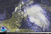
The tropical storm made landfall
on the Yucatán Peninsula
near Cancún
early on July 21, leaving at least 17 people dead in Guatemala
, and one person in the Yucatán. It moved into the Gulf of Mexico
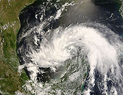
and strengthened to become a Category 2 hurricane, before weakening some and making landfall as a Category 1 storm on July 23 in South Padre Island
, Texas
, with 85 mph (140 km/h) winds. The storm caused 212,000 customers to lose power in Texas as well as 125,000 in Tamaulipas
, and dropped estimated amounts of over 16 inches (410 mm) of rain in isolated areas . Rip currents throughout the entire Gulf Coast resulted in one person drowning off the Florida Panhandle
. There were no deaths as a result of Hurricane Dolly in Texas; it did, however, cause an estimated $1.05 billion dollars in damage. The remnants of the storm caused two deaths in New Mexico.
on July 13 in association with a strong tropical wave. The wave tracked across the Caribbean Sea
during the third week of July. Despite producing strong convection and tropical storm-force sustained winds, it failed to develop a low-level circulation until July 20. That morning, reconnaissance aircraft
found a low-level circulation and the system was identified as a tropical cyclone
by the National Hurricane Center
(NHC). The reconnaissance data showed that the storm had maximum sustained wind
s exceeding the 34-knot (39 mph; 63 km/h) threshold for tropical storm status
. Additionally, buoy
data corroborated that the system was producing speeds of this velocity at sea level, so the NHC declared the system to be a tropical storm—bypassing the tropical depression stage altogether—and giving it the name Dolly
.
At this point, Dolly was located 270 mi (435 km) east of Chetumal
, and 230 mi (365 km) southeast of Cozumel
; the tropical storm was expected to make landfall
later that day. At the time of Dolly's approach to Quintana Roo
, 100,000 tourists were in the state, and 45,000 of them in Cancún
. Originally, the storm was forecast by the Servicio Meteorológico Nacional
(Mexico's national weather service) to make landfall between Playa del Carmen
and Tulum. However, as the storm approached the Quintana Roo coastline, it lost its organization and its surface circulation center disappeared. When the storm was just offshore, it began reorganizing, and a new circulation center formed in the heavy convection
on the northern sector of the storm. In essence, this caused the storm to briefly move parallel to the coastline, shifting the point of Dolly's first landfall to north of Cancún. The northward shift also caused the bulk of the storm to stay over water, reducing its impact on the Yucatán Peninsula.
After moving into the Gulf of Mexico
, weather conditions became favorable for additional intensification
, with low wind shear
and warm sea surface temperature
s. Dolly strengthened steadily beginning on July 21, and by the afternoon of July 22, it strengthened into a Category 1 hurricane on the Saffir-Simpson Hurricane Scale
. At this point, the storm was located about 165 mi (265 km) east-southeast of Brownsville, Texas
. Steady strengthening continued that evening and into the morning of July 23, at which point Dolly reached Category 2 intensity while just east of the Rio Grande Valley
at 10:00 am that morning with winds of up to 100 mph (160 km/h) and a minimum central pressure of 963 mbar. At 1:00 pm CDT (1800 UTC) that same day, Dolly made landfall
on South Padre Island
, Texas
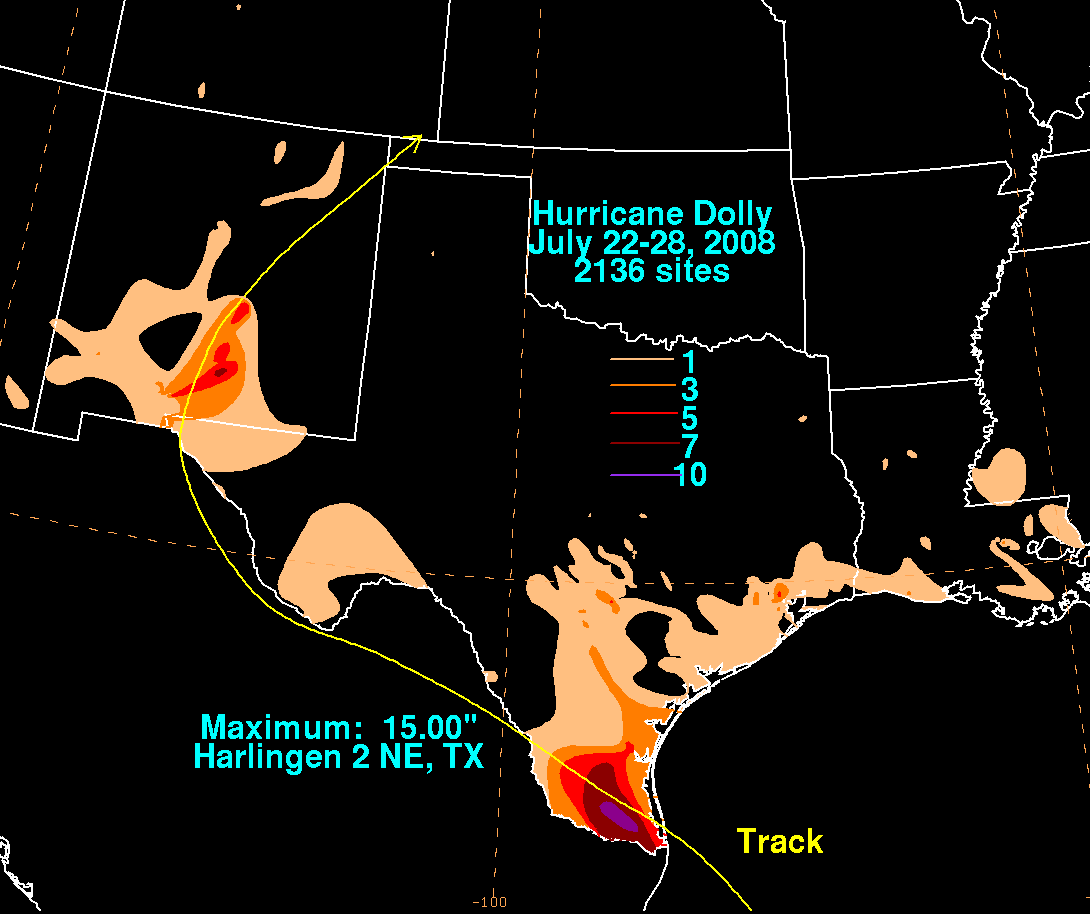
, slightly weaker as a Category 1 hurricane with 85 mph (140 km/h) sustained winds and a pressure of 967 mbar. Hurricane Dolly then moved west-northwestward over the Laguna Madre crossing onto the mainland near the Cameron-Willacy County line. South Padre Island, Port Isabel, Laguna Vista, Los Fresnos, Bayview, Brownsville, San Benito, Rio Hondo, Arroyo City and especially Harlingen suffered heavy wind and flooding. Hurricane Dolly then thrashed the Delta Region along and north of Highway 107 with its most fierce winds and rain. Towns like Santa Rosa, La Villa, Edcouch, Elsa, Monte Alto and San Carlos were hit hard by the slow-moving, wet hurricane which dumped 10-20 inch rains. According to Mid Valley Town-Crier newspaper, the Weslaco Airport clocked gusts of 68 knots (78 mph). Dolly weakened to a tropical storm after passing US 281 (west of San Manuel and Linn, Texas) late on the 23rd, and then a tropical depression, as it moved slowly inland into Mexico. The circulation weakened into a remnant low over northern Mexico on the afternoon of July 25, then crossed back into the United States, passing through the Ciudad Juárez, Chihuahua/El Paso, Texas
metropolitan area on the morning of July 26 and then north across New Mexico
. The remnant low of Dolly finally began to dissipate late in the evening of July 27 approximately 100 km (62.1 mi) west-northwest of Dalhart, Texas
.
 On July 20, the Mexican government issued a tropical storm warning for the Yucatán Peninsula
from Campeche
to the international border with Belize
. A few hours later, Belize's government issued a tropical storm watch from Belize City
to the Mexican border
.
 That same morning, the Quintana Roo
Civil Protection authorities in Chetumal
declared a "blue alert" for the entire state due to the storm's proximity. This alert was upgraded to an "orange alert" that afternoon, and to a "red alert" that evening. On Cozumel
, the ferry service connecting the island to the mainland was suspended, and local government oulawed sales of alcohol and asked residents to stay in their homes after 6:00 pm local time. The state government also ordered the evacuation of 1,000 people from the island of Banco Chinchorro
and village of Punta Allen
, and evacuations were also ordered in Tulum. Later, evacuation orders were also made for Holbox Island
, causing the total number of evacuees to reach 2,000. In the Solidaridad
municipality, 238 people were put in shelters to weather out the storm. Elsewhere, five shelters were made available to the population, but only one family of three used them. The Yucatán
state government issued a blue alert, followed by an orange alert when the storm approached the state.
 The National Hurricane Center and the Mexican government issued hurricane watches for the coast between the San Fernando River
in Tamaulipas
and Port O'Connor, Texas
. At the same time, a tropical storm watch was issued for the Texas coast between Port O'Connor
and San Luis Pass
, and for the Gulf coast from the San Fernando River
southward to La Pesca, Tamaulipas
. That evening, at 10 p.m. CDT (0300 UTC July 22), the hurricane watches and tropical storm watches in both countries were upgraded to hurricane warnings and tropical storm warnings, respectively. At the same time, the Mexican government issued a hurricane watch between the San Fernando River and La Pesca.
In the Gulf of Mexico
, Royal Dutch Shell
evacuated 125 personnel from its oil rigs on July 20, and evacuated another 60 on July 21. Diamond Offshore Drilling
removed non-essential employees from some of its rigs, and the Rowan Companies
also evacuated one of their eight oil rig
s in the Gulf. Also on July 21, Chevron
announced that it was evacuating some of its workers from its oil rigs in the Gulf, but did not disclose how many were removed. On July 22, BP
announced the evacuation of non-essential personnel from two of its rigs, and on July 23, Petróleos Mexicanos
evacuated 66 people from one of its rigs. In spite of this, oil production was not expected to be affected by Dolly.
In Texas
, Governor
Rick Perry
activated 1,200 members of the Texas Military Forces
, among other emergency personnel. Perry also ordered 250 buses to be placed in San Antonio, so they could be used if evacuations became necessary. Perry declared 14 counties of the state as disaster area
s on July 22. The Texas Department of Transportation
put construction contractors in the Rio Grande Valley
on notice of a possible storm. Cameron County
emergency officials urged residents living along the Rio Grande
to evacuate, for fear of the levee
s alongside the river bursting. Port of Brownsville officials also decided to close the port at midnight Wednesday, July 23, through midnight Friday, July 25. The United States Navy
removed 104 airplanes from Truax Field
and flew them to bases further inland, and Immigration and Customs Enforcement
evacuated its detention facility in Port Isabel
.
On July 21, the state of Veracruz
put 166 municipalities in preventive alert, and expected that the storm would exacerbate existing flooding. In Tamaulipas
, state authorities put the municipalities of Soto la Marina
, San Fernando
, Matamoros
, Valle Hermoso
, Río Bravo
and Reynosa
on alert and prepared shelters. Later, on July 22, 23,000 people were planned to be evacuated from Matamoros, Soto la Marina and San Fernando; however, of those, only about 13,000 followed the evacuation order, and were placed in 21 shelters. 15 shelters—with a capacity to hold 4,500 people—were activated in Reynosa. On the night of July 22, the federal government, through the Secretaría de Gobernación
(SEGOB), declared a state of emergency
in 17 municipalities, making them eligible to receive federal assistance funding. SEGOB also ordered 600 Army
troops and 350 Marines
deployed to Tamaulipas, a number that later grew to 4,800 military and police. Further inland, on July 21, the Nuevo León
state government began to prepare 300 shelters throughout the state, and the Coahuila
state government announced a state of alert the next day. On July 23, Coahuila authorities emitted an orange alert due to the risk of flooding from Dolly's remnants, and activated 2,000 military and police to the state.
in the department of Zacapa
and four from another family in San Pedro Soloma
, Huehuetenango
. One more person drowned after trying to cross the flooded Punilá River in La Unión.
Before it made landfall, Dolly caused heavy rain in western Cuba
, primarily in the provinces of Isla de la Juventud, Pinar del Río
and La Habana.
In Mexico, the state of Quintana Roo
reported no deaths from the storm, and no major damage was reported in Cancún
; however, the city reported significant beach erosion. Four fisherman were reported missing after Dolly passed over the Yucatán peninsula, and one of them was found dead on the beach near Puerto Progreso, Yucatán
.
in the New York Mercantile Exchange
on July 21, although prices fell again after Dolly missed most of the oil rigs in the Gulf. The Minerals Management Service
indicated that Dolly caused 4.66% of the total oil production and 5.13% of the natural gas
production to be shut in.
 In the United States
, President
George W. Bush
declared 15 counties of Texas as a federal disaster area
. Hurricane Dolly is considered to be the most destructive hurricane to hit the Rio Grande Valley
in 41 years; the last such storm was Beulah
in 1967, but Beulah was not more damaging; it was just deadlier. It was the worst hurricane to hit Brownsville since 1980's Allen
. No deaths were reported as a result of the storm, but one boy was injured after falling seven floors from a condominium balcony in South Padre Island
. Early on July 23, an apartment complex roof partially collapsed in South Padre Island
. Power was knocked out to more than 13,000 customers in Cameron County, Texas
and 15,100 in Hidalgo County, Texas
. Sustained winds were estimated at 100 mph with gusts of 120 mph when Dolly made landfall. Dolly's strongest winds and heaviest rains were generally on the left or south side of the eyewall. The winds blew signs off of many hotels. Residents of Brownsville
reported downed tree limbs, among other small damages. In addition, at least two tornadoes were reported in San Patricio County, well to the north of the landfall location. One of them uprooted trees and knocked over several roofs and weak structures. By noon on July 23, the storm had left 36,000 customers in south Texas without electric power, a number that rose to 61,000 by 3:00 p.m, and to 122,800 by 6:00 p.m. At the height of the disaster, some 155,000 homes were without electricity. The damage in South Texas was much more destructive than what was predicted. Dozens of homes and businesses were destroyed with hundreds more damaged, and the storm surge caused many boats to brought onshore, some into homes.
 The Governor of Texas
, Rick Perry
, declared 14 counties in South Texas
a disaster area
. Insured property damage estimates are near $525 million (2008 USD) with total property damage estimates (based on a 2–1 ratio of total damage to insured damage) near $1.05 billion (2008 USD) in the state (with a large proportion of the losses being agricultural), and the Rio Grande cotton
crop was expected to be a complete loss. After weakening to a tropical storm, Dolly spun off another tornado near Poth
early on July 24 with minor damage. Near noon on July 24, an EF0
tornado
touched down in the southern edge of downtown
San Antonio
near the Interstate 10
–Interstate 37
interchange. Significant damage was reported in the area, with several commercial buildings losing their roofs and numerous houses damaged. Damage was also reported at the Windcrest Tower. About 1,500 customers lost power as a result. Flash flooding from the remnant low of Dolly occurred in El Paso, Texas
on July 26: one person was killed in an adjacent portion of New Mexico
from a weather-related traffic accident. Additional flash flooding and river flooding on the Rio Ruidoso
in the Sacramento Mountains
of New Mexico occurred on the morning of July 27, after more than 6 in (152.4 mm) of rainfall from Dolly's remnants: hundreds of tourists, campers and residents were evacuated and the storm caused damage at the Ruidoso Downs racetrack. One person was killed in the Rio Ruidoso flooding, approximately 900 persons required rescue, approximately 500 structures were damaged, and initial damage estimates for Ruidoso, New Mexico
were in the range of $15–20 million.
 Distant effects included high waves and rip currents throughout the Gulf of Mexico. One person was killed and at least nine others had to be rescued from Panama City Beach, Florida
, as a result of rip currents caused by Dolly.
The remnants of Dolly also impacted the south and middle of the midwest including the Chicago metropolitan area and Illinois
, Indiana
, Tennessee
, and some parts of southern Missouri
causing severe weather reports and some damage of property.
, downed power lines fell on floodwaters and electrocuted one man to death. The hurricane caused 19 colonias
to lose electric power, and about 125,000 users lost power the night after Dolly's second landfall. 111 colonias were flooded, and 50 of those suffered severe flooding. The storm also knocked down trees, billboards and traffic signals in the city. Soldiers rescued a family trapped in their home near the mouth of the Rio Grande
. On July 26, the remnant low of Dolly dropped heavy rains on Ciudad Juarez, Chihuahua, causing landslides, flooding, the collapse of a historic church and evacuation of numerous colonias
. Damage estimates in Mexico are around $300 million (2008 USD).
in 2005. Dolly was also the second most destructive U.S. hurricane in July, behind Dennis. It also marked the fastest start of a hurricane season since 2005. Dolly's estimated damage in Texas was $1.05 billion which made it the 4th most destructive Texas hurricane on record (based on total cost), behind Hurricane Alicia
, Hurricane Rita
, and Hurricane Ike
later in 2008.
Tropical cyclone
A tropical cyclone is a storm system characterized by a large low-pressure center and numerous thunderstorms that produce strong winds and heavy rain. Tropical cyclones strengthen when water evaporated from the ocean is released as the saturated air rises, resulting in condensation of water vapor...
that made landfall in extreme southern Texas
Texas
Texas is the second largest U.S. state by both area and population, and the largest state by area in the contiguous United States.The name, based on the Caddo word "Tejas" meaning "friends" or "allies", was applied by the Spanish to the Caddo themselves and to the region of their settlement in...
in July 2008. Dolly was the fourth tropical cyclone
Tropical cyclone
A tropical cyclone is a storm system characterized by a large low-pressure center and numerous thunderstorms that produce strong winds and heavy rain. Tropical cyclones strengthen when water evaporated from the ocean is released as the saturated air rises, resulting in condensation of water vapor...
and second hurricane to form during the 2008 Atlantic hurricane season
2008 Atlantic hurricane season
The 2008 Atlantic hurricane season was a very active hurricane season with sixteen named storms formed, including eight that became hurricanes and five that became major hurricanes. The season officially started on June 1 and ended on November 30. These dates conventionally delimit the period of...
. It was the first U.S. landfalling hurricane of the 2008 season. Dolly developed on July 20 from an area of disturbed weather in association with a strong tropical wave
Tropical wave
Tropical waves, easterly waves, or tropical easterly waves, also known as African easterly waves in the Atlantic region, are a type of atmospheric trough, an elongated area of relatively low air pressure, oriented north to south, which move from east to west across the tropics causing areas of...
. It was named Dolly at the same time it formed—skipping the tropical depression phase entirely as the precursor wave already had tropical storm-force winds. This marked the earliest time a fourth named cyclone has formed since the 2005 season
2005 Atlantic hurricane season
The 2005 Atlantic hurricane season was the most active Atlantic hurricane season in recorded history, repeatedly shattering numerous records. The impact of the season was widespread and ruinous with an estimated 3,913 deaths and record damage of about $159.2 billion...
, which holds the record.
The tropical storm made landfall
Landfall (meteorology)
Landfall is the event of a tropical cyclone or a waterspout coming onto land after being over water. When a waterspout makes landfall it is reclassified as a tornado, which can then cause damage inland...
on the Yucatán Peninsula
Yucatán Peninsula
The Yucatán Peninsula, in southeastern Mexico, separates the Caribbean Sea from the Gulf of Mexico, with the northern coastline on the Yucatán Channel...
near Cancún
Cancún
Cancún is a city of international tourism development certified by the UNWTO . Located on the northeast coast of Quintana Roo in southern Mexico, more than 1,700 km from Mexico City, the Project began operations in 1974 as Integrally Planned Center, a pioneer of FONATUR Cancún is a city of...
early on July 21, leaving at least 17 people dead in Guatemala
Guatemala
Guatemala is a country in Central America bordered by Mexico to the north and west, the Pacific Ocean to the southwest, Belize to the northeast, the Caribbean to the east, and Honduras and El Salvador to the southeast...
, and one person in the Yucatán. It moved into the Gulf of Mexico
Gulf of Mexico
The Gulf of Mexico is a partially landlocked ocean basin largely surrounded by the North American continent and the island of Cuba. It is bounded on the northeast, north and northwest by the Gulf Coast of the United States, on the southwest and south by Mexico, and on the southeast by Cuba. In...
and strengthened to become a Category 2 hurricane, before weakening some and making landfall as a Category 1 storm on July 23 in South Padre Island
South Padre Island
South Padre Island is a barrier island in the U.S. state of Texas. It is located in Cameron County and is a popular vacation destination because the resort city South Padre Island is located on the island. The island itself is considered to have been settled by Padre Jose Nicolas Balli, who had a...
, Texas
Texas
Texas is the second largest U.S. state by both area and population, and the largest state by area in the contiguous United States.The name, based on the Caddo word "Tejas" meaning "friends" or "allies", was applied by the Spanish to the Caddo themselves and to the region of their settlement in...
, with 85 mph (140 km/h) winds. The storm caused 212,000 customers to lose power in Texas as well as 125,000 in Tamaulipas
Tamaulipas
Tamaulipas officially Estado Libre y Soberano de Tamaulipas is one of the 31 states which, with the Federal District, comprise the 32 Federal Entities of Mexico. It is divided in 43 municipalities and its capital city is Ciudad Victoria. The capital city was named after Guadalupe Victoria, the...
, and dropped estimated amounts of over 16 inches (410 mm) of rain in isolated areas . Rip currents throughout the entire Gulf Coast resulted in one person drowning off the Florida Panhandle
Florida Panhandle
The Florida Panhandle, an informal, unofficial term for the northwestern part of Florida, is a strip of land roughly 200 miles long and 50 to 100 miles wide , lying between Alabama on the north and the west, Georgia also on the north, and the Gulf of Mexico to the south. Its eastern boundary is...
. There were no deaths as a result of Hurricane Dolly in Texas; it did, however, cause an estimated $1.05 billion dollars in damage. The remnants of the storm caused two deaths in New Mexico.
Meteorological history
An area of disturbed weather formed over the tropical Atlantic about 1600 miles (2600 km) east of the southern Windward IslandsWindward Islands
The Windward Islands are the southern islands of the Lesser Antilles, within the West Indies.-Name and geography:The Windward Islands are called such because they were more windward to sailing ships arriving in the New World than the Leeward Islands, given that the prevailing trade winds in the...
on July 13 in association with a strong tropical wave. The wave tracked across the Caribbean Sea
Caribbean Sea
The Caribbean Sea is a sea of the Atlantic Ocean located in the tropics of the Western hemisphere. It is bounded by Mexico and Central America to the west and southwest, to the north by the Greater Antilles, and to the east by the Lesser Antilles....
during the third week of July. Despite producing strong convection and tropical storm-force sustained winds, it failed to develop a low-level circulation until July 20. That morning, reconnaissance aircraft
Hurricane Hunters
The Hurricane Hunters are aircraft that fly into tropical cyclones in the North Atlantic Ocean and Northeastern Pacific Ocean for the specific purpose of directly measuring weather data in and around those storms. In the United States, the Air Force, Navy, and NOAA units have all participated in...
found a low-level circulation and the system was identified as a tropical cyclone
Tropical cyclone
A tropical cyclone is a storm system characterized by a large low-pressure center and numerous thunderstorms that produce strong winds and heavy rain. Tropical cyclones strengthen when water evaporated from the ocean is released as the saturated air rises, resulting in condensation of water vapor...
by the National Hurricane Center
National Hurricane Center
The National Hurricane Center , located at Florida International University in Miami, Florida, is the division of the National Weather Service responsible for tracking and predicting weather systems within the tropics between the Prime Meridian and the 140th meridian west poleward to the 30th...
(NHC). The reconnaissance data showed that the storm had maximum sustained wind
Maximum sustained wind
The maximum sustained winds associated with a tropical cyclone are a common indicator of the intensity of the storm. Within a mature tropical cyclone, they are found within the eyewall at a distance defined as the radius of maximum wind, or RMW. Unlike gusts, the value of these winds are...
s exceeding the 34-knot (39 mph; 63 km/h) threshold for tropical storm status
Tropical cyclone scales
Tropical systems are officially ranked on one of several tropical cyclone scales according to their maximum sustained winds and in what oceanic basin they are located...
. Additionally, buoy
Buoy
A buoy is a floating device that can have many different purposes. It can be anchored or allowed to drift. The word, of Old French or Middle Dutch origin, is now most commonly in UK English, although some orthoepists have traditionally prescribed the pronunciation...
data corroborated that the system was producing speeds of this velocity at sea level, so the NHC declared the system to be a tropical storm—bypassing the tropical depression stage altogether—and giving it the name Dolly
Dolly
Dolly may refer to one of the following:*Camera dolly, platform that enables a movie or video camera to move during shots*Dolly , a portable anvil*Dolly , for towing behind a vehicle...
.
At this point, Dolly was located 270 mi (435 km) east of Chetumal
Chetumal
Chetumal is a city on the east coast of the Yucatán Peninsula in Mexico. It is the capital of the state of Quintana Roo and the municipal seat of the Municipality of Othón P. Blanco...
, and 230 mi (365 km) southeast of Cozumel
Cozumel
Cozumel is an island in the Caribbean Sea off the eastern coast of Mexico's Yucatan Peninsula, opposite Playa del Carmen, and close to the Yucatan Channel. Cozumel is one of the ten municipalities of the state of Quintana Roo...
; the tropical storm was expected to make landfall
Landfall (meteorology)
Landfall is the event of a tropical cyclone or a waterspout coming onto land after being over water. When a waterspout makes landfall it is reclassified as a tornado, which can then cause damage inland...
later that day. At the time of Dolly's approach to Quintana Roo
Quintana Roo
Quintana Roo officially Estado Libre y Soberano de Quintana Roo is one of the 31 states which, with the Federal District, comprise the 32 Federal Entities of Mexico. It is divided in 10 municipalities and its capital city is Chetumal....
, 100,000 tourists were in the state, and 45,000 of them in Cancún
Cancún
Cancún is a city of international tourism development certified by the UNWTO . Located on the northeast coast of Quintana Roo in southern Mexico, more than 1,700 km from Mexico City, the Project began operations in 1974 as Integrally Planned Center, a pioneer of FONATUR Cancún is a city of...
. Originally, the storm was forecast by the Servicio Meteorológico Nacional
Servicio Meteorológico Nacional
The Servicio Meteorológico Nacional is Mexico's national weather organization. It collects data and issues forecasts, advisories, and warnings for the entire country.-History:...
(Mexico's national weather service) to make landfall between Playa del Carmen
Playa del Carmen
Playa del Carmen is a balneario resort city just south of Cancún on the coast of the Caribbean Sea, in the northeast of the Mexican state of Quintana Roo. The city is the seat of the Solidaridad municipality. In the 2010 census, the city had a population of 149,923 people and it is rapidly growing...
and Tulum. However, as the storm approached the Quintana Roo coastline, it lost its organization and its surface circulation center disappeared. When the storm was just offshore, it began reorganizing, and a new circulation center formed in the heavy convection
Atmospheric convection
Atmospheric convection is the result of a parcel-environment instability, or temperature difference, layer in the atmosphere. Different lapse rates within dry and moist air lead to instability. Mixing of air during the day which expands the height of the planetary boundary layer leads to...
on the northern sector of the storm. In essence, this caused the storm to briefly move parallel to the coastline, shifting the point of Dolly's first landfall to north of Cancún. The northward shift also caused the bulk of the storm to stay over water, reducing its impact on the Yucatán Peninsula.
After moving into the Gulf of Mexico
Gulf of Mexico
The Gulf of Mexico is a partially landlocked ocean basin largely surrounded by the North American continent and the island of Cuba. It is bounded on the northeast, north and northwest by the Gulf Coast of the United States, on the southwest and south by Mexico, and on the southeast by Cuba. In...
, weather conditions became favorable for additional intensification
Tropical cyclogenesis
Tropical cyclogenesis is the term that describes the development and strengthening of a tropical cyclone in the atmosphere. The mechanisms through which tropical cyclogenesis occurs are distinctly different from those through which mid-latitude cyclogenesis occurs...
, with low wind shear
Wind shear
Wind shear, sometimes referred to as windshear or wind gradient, is a difference in wind speed and direction over a relatively short distance in the atmosphere...
and warm sea surface temperature
Sea surface temperature
Sea surface temperature is the water temperature close to the oceans surface. The exact meaning of surface varies according to the measurement method used, but it is between and below the sea surface. Air masses in the Earth's atmosphere are highly modified by sea surface temperatures within a...
s. Dolly strengthened steadily beginning on July 21, and by the afternoon of July 22, it strengthened into a Category 1 hurricane on the Saffir-Simpson Hurricane Scale
Saffir-Simpson Hurricane Scale
The Saffir–Simpson Hurricane Scale , or the Saffir–Simpson Hurricane Wind Scale , classifies hurricanes — Western Hemisphere tropical cyclones that exceed the intensities of tropical depressions and tropical storms — into five categories distinguished by the intensities of their sustained winds...
. At this point, the storm was located about 165 mi (265 km) east-southeast of Brownsville, Texas
Brownsville, Texas
Brownsville is a city in the southernmost tip of the state of Texas, in the United States. It is located on the northern bank of the Rio Grande, directly north and across the border from Matamoros, Tamaulipas, Mexico. Brownsville is the 16th largest city in the state of Texas with a population of...
. Steady strengthening continued that evening and into the morning of July 23, at which point Dolly reached Category 2 intensity while just east of the Rio Grande Valley
Rio Grande Valley
The Rio Grande Valley or the Lower Rio Grande Valley, informally called The Valley, is an area located in the southernmost tip of South Texas...
at 10:00 am that morning with winds of up to 100 mph (160 km/h) and a minimum central pressure of 963 mbar. At 1:00 pm CDT (1800 UTC) that same day, Dolly made landfall
Landfall (meteorology)
Landfall is the event of a tropical cyclone or a waterspout coming onto land after being over water. When a waterspout makes landfall it is reclassified as a tornado, which can then cause damage inland...
on South Padre Island
South Padre Island
South Padre Island is a barrier island in the U.S. state of Texas. It is located in Cameron County and is a popular vacation destination because the resort city South Padre Island is located on the island. The island itself is considered to have been settled by Padre Jose Nicolas Balli, who had a...
, Texas
Texas
Texas is the second largest U.S. state by both area and population, and the largest state by area in the contiguous United States.The name, based on the Caddo word "Tejas" meaning "friends" or "allies", was applied by the Spanish to the Caddo themselves and to the region of their settlement in...
, slightly weaker as a Category 1 hurricane with 85 mph (140 km/h) sustained winds and a pressure of 967 mbar. Hurricane Dolly then moved west-northwestward over the Laguna Madre crossing onto the mainland near the Cameron-Willacy County line. South Padre Island, Port Isabel, Laguna Vista, Los Fresnos, Bayview, Brownsville, San Benito, Rio Hondo, Arroyo City and especially Harlingen suffered heavy wind and flooding. Hurricane Dolly then thrashed the Delta Region along and north of Highway 107 with its most fierce winds and rain. Towns like Santa Rosa, La Villa, Edcouch, Elsa, Monte Alto and San Carlos were hit hard by the slow-moving, wet hurricane which dumped 10-20 inch rains. According to Mid Valley Town-Crier newspaper, the Weslaco Airport clocked gusts of 68 knots (78 mph). Dolly weakened to a tropical storm after passing US 281 (west of San Manuel and Linn, Texas) late on the 23rd, and then a tropical depression, as it moved slowly inland into Mexico. The circulation weakened into a remnant low over northern Mexico on the afternoon of July 25, then crossed back into the United States, passing through the Ciudad Juárez, Chihuahua/El Paso, Texas
El Paso, Texas
El Paso, is a city in and the county seat of El Paso County, Texas, United States, and lies in far West Texas. In the 2010 census, the city had a population of 649,121. It is the sixth largest city in Texas and the 19th largest city in the United States...
metropolitan area on the morning of July 26 and then north across New Mexico
New Mexico
New Mexico is a state located in the southwest and western regions of the United States. New Mexico is also usually considered one of the Mountain States. With a population density of 16 per square mile, New Mexico is the sixth-most sparsely inhabited U.S...
. The remnant low of Dolly finally began to dissipate late in the evening of July 27 approximately 100 km (62.1 mi) west-northwest of Dalhart, Texas
Dalhart, Texas
Dalhart is a city in Dallam and Hartley counties in the U.S. state of Texas, and the county seat of Dallam County. The population was 7,237 at the 2000 census. Founded in 1901, Dalhart is named for its location on the border of Dallam and Hartley counties. Dalhart sits at the intersection of U.S....
.
First landfall
Yucatán Peninsula
The Yucatán Peninsula, in southeastern Mexico, separates the Caribbean Sea from the Gulf of Mexico, with the northern coastline on the Yucatán Channel...
from Campeche
Campeche, Campeche
San Francisco de Campeche is the capital city of the Mexican state of Campeche, located at,...
to the international border with Belize
Belize
Belize is a constitutional monarchy and the northernmost country in Central America. Belize has a diverse society, comprising many cultures and languages. Even though Kriol and Spanish are spoken among the population, Belize is the only country in Central America where English is the official...
. A few hours later, Belize's government issued a tropical storm watch from Belize City
Belize City
Belize City is the largest city in the Central American nation of Belize. Unofficial estimates place the population of Belize City at 70,000 or more. It is located at the mouth of the Belize River on the coast of the Caribbean. The city is the country's principal port and its financial and...
to the Mexican border
Belize–Mexico border
The Belize–Mexico border is the international border between Belize and Mexico. It is 251 km long and almost exclusively follows the course of the Hondo River. It separates Belize from the Mexican states of Quintana Roo and Campeche ....
.
Quintana Roo
Quintana Roo officially Estado Libre y Soberano de Quintana Roo is one of the 31 states which, with the Federal District, comprise the 32 Federal Entities of Mexico. It is divided in 10 municipalities and its capital city is Chetumal....
Civil Protection authorities in Chetumal
Chetumal
Chetumal is a city on the east coast of the Yucatán Peninsula in Mexico. It is the capital of the state of Quintana Roo and the municipal seat of the Municipality of Othón P. Blanco...
declared a "blue alert" for the entire state due to the storm's proximity. This alert was upgraded to an "orange alert" that afternoon, and to a "red alert" that evening. On Cozumel
Cozumel
Cozumel is an island in the Caribbean Sea off the eastern coast of Mexico's Yucatan Peninsula, opposite Playa del Carmen, and close to the Yucatan Channel. Cozumel is one of the ten municipalities of the state of Quintana Roo...
, the ferry service connecting the island to the mainland was suspended, and local government oulawed sales of alcohol and asked residents to stay in their homes after 6:00 pm local time. The state government also ordered the evacuation of 1,000 people from the island of Banco Chinchorro
Banco Chinchorro
Banco Chinchorro is an atoll reef lying off the southeast coast of the Municipality of Othón P. Blanco in Quintana Roo, Mexico, near Belize that is one of the world's premiere shipwreck diving spots...
and village of Punta Allen
Punta Allen
Punta Allen is the largest village in the Sian Ka'an Biosphere Reserve at the end of the Boca Paila peninsula in Tulum Municipality in the Mexican state of Quintana Roo...
, and evacuations were also ordered in Tulum. Later, evacuation orders were also made for Holbox Island
Isla Holbox
Holbox is an island in the Mexican state of Quintana Roo, located on the north coast of the Yucatán Peninsula. It is approximately 12 kilometers long and 1.5 kilometers wide, and it is separated from the mainland by a shallow lagoon that is home to flamingos, pelicans and other rich birdlife...
, causing the total number of evacuees to reach 2,000. In the Solidaridad
Solidaridad, Quintana Roo
Solidaridad is one of the ten municipalities that make up the Mexican state of Quintana Roo. It is also one of the youngest municipalities in the country and was formed on July 28 of 1993 by decree of the State Congress during the administration of Mario Villanueva Madrid...
municipality, 238 people were put in shelters to weather out the storm. Elsewhere, five shelters were made available to the population, but only one family of three used them. The Yucatán
Yucatán
Yucatán officially Estado Libre y Soberano de Yucatán is one of the 31 states which, with the Federal District, comprise the 32 Federal Entities of Mexico. It is divided in 106 municipalities and its capital city is Mérida....
state government issued a blue alert, followed by an orange alert when the storm approached the state.
Second landfall
San Fernando River
-References:*Atlas of Mexico, 1975 .*The Prentice Hall American World Atlas, 1984.*Rand McNally, The New International Atlas, 1993....
in Tamaulipas
Tamaulipas
Tamaulipas officially Estado Libre y Soberano de Tamaulipas is one of the 31 states which, with the Federal District, comprise the 32 Federal Entities of Mexico. It is divided in 43 municipalities and its capital city is Ciudad Victoria. The capital city was named after Guadalupe Victoria, the...
and Port O'Connor, Texas
Port O'Connor, Texas
Port O'Connor is an unincorporated village in Calhoun County, Texas, United States, on the coastline between Galveston and Corpus Christi. The ZIP Code Tabulation Area including Port O'Connor had a population of 1,078 at the 2000 census...
. At the same time, a tropical storm watch was issued for the Texas coast between Port O'Connor
Port O'Connor, Texas
Port O'Connor is an unincorporated village in Calhoun County, Texas, United States, on the coastline between Galveston and Corpus Christi. The ZIP Code Tabulation Area including Port O'Connor had a population of 1,078 at the 2000 census...
and San Luis Pass
San Luis Pass
San Luis Pass is a strait of water at the south-western end of Galveston Island off the shores of the U.S. state of Texas. It connects the sheltered waters of West Bay to the open Gulf of Mexico.-Fishing:...
, and for the Gulf coast from the San Fernando River
San Fernando River
-References:*Atlas of Mexico, 1975 .*The Prentice Hall American World Atlas, 1984.*Rand McNally, The New International Atlas, 1993....
southward to La Pesca, Tamaulipas
La Pesca, Tamaulipas
La Pesca is a small town in the Mexican state of Tamaulipas. It is located on the Gulf of Mexico, at the mouth of the Río Soto La Marina, between the Laguna Madre to the north and the Laguna Morales to the south....
. That evening, at 10 p.m. CDT (0300 UTC July 22), the hurricane watches and tropical storm watches in both countries were upgraded to hurricane warnings and tropical storm warnings, respectively. At the same time, the Mexican government issued a hurricane watch between the San Fernando River and La Pesca.
In the Gulf of Mexico
Gulf of Mexico
The Gulf of Mexico is a partially landlocked ocean basin largely surrounded by the North American continent and the island of Cuba. It is bounded on the northeast, north and northwest by the Gulf Coast of the United States, on the southwest and south by Mexico, and on the southeast by Cuba. In...
, Royal Dutch Shell
Royal Dutch Shell
Royal Dutch Shell plc , commonly known as Shell, is a global oil and gas company headquartered in The Hague, Netherlands and with its registered office in London, United Kingdom. It is the fifth-largest company in the world according to a composite measure by Forbes magazine and one of the six...
evacuated 125 personnel from its oil rigs on July 20, and evacuated another 60 on July 21. Diamond Offshore Drilling
Diamond Offshore Drilling
Diamond Offshore Drilling, Inc. is a deepwater drilling contractor which provides drilling services to the oil and gas industry. The company's headquarters are located in Houston, Texas, but they have offices in Metairie, Louisiana, Africa, Australia, Brazil, Indonesia, Scotland, Singapore, Norway...
removed non-essential employees from some of its rigs, and the Rowan Companies
Rowan Companies
Rowan Companies, Inc. , founded in 1923 and based in Houston, Texas, is an S&P 500 company which provides contract oil well drilling services and rigs, and manufactures equipment for drilling as well as for mining and timber industries. Rowan Companies is located at 2800 Post Oak Boulevard, Suite...
also evacuated one of their eight oil rig
Oil platform
An oil platform, also referred to as an offshore platform or, somewhat incorrectly, oil rig, is a lаrge structure with facilities to drill wells, to extract and process oil and natural gas, and to temporarily store product until it can be brought to shore for refining and marketing...
s in the Gulf. Also on July 21, Chevron
Chevron Corporation
Chevron Corporation is an American multinational energy corporation headquartered in San Ramon, California, United States and active in more than 180 countries. It is engaged in every aspect of the oil, gas, and geothermal energy industries, including exploration and production; refining,...
announced that it was evacuating some of its workers from its oil rigs in the Gulf, but did not disclose how many were removed. On July 22, BP
BP
BP p.l.c. is a global oil and gas company headquartered in London, United Kingdom. It is the third-largest energy company and fourth-largest company in the world measured by revenues and one of the six oil and gas "supermajors"...
announced the evacuation of non-essential personnel from two of its rigs, and on July 23, Petróleos Mexicanos
Pemex
Petróleos Mexicanos or Pemex is a Mexican state-owned petroleum company. As of 2010, with a total asset worth of $415.75 billion, it is the second non-publicly listed largest company in the world by total market value, and Latin America's second largest enterprise by annual revenue as of 2009...
evacuated 66 people from one of its rigs. In spite of this, oil production was not expected to be affected by Dolly.
In Texas
Texas
Texas is the second largest U.S. state by both area and population, and the largest state by area in the contiguous United States.The name, based on the Caddo word "Tejas" meaning "friends" or "allies", was applied by the Spanish to the Caddo themselves and to the region of their settlement in...
, Governor
Governor of Texas
The governor of Texas is the head of the executive branch of Texas's government and the commander-in-chief of the state's military forces. The governor has the power to either approve or veto bills passed by the Texas Legislature, and to convene the legislature...
Rick Perry
Rick Perry
James Richard "Rick" Perry is the 47th and current Governor of Texas. A Republican, Perry was elected Lieutenant Governor of Texas in 1998 and assumed the governorship in December 2000 when then-governor George W. Bush resigned to become President of the United States. Perry was elected to full...
activated 1,200 members of the Texas Military Forces
Texas Military Forces
The Texas Military Forces is the combined military strength of the U.S. state of Texas. It is composed of three branches, the Texas Army National Guard, the Texas Air National Guard, and the Texas State Guard; all report to the state Adjutant General and are under the command of the Governor of...
, among other emergency personnel. Perry also ordered 250 buses to be placed in San Antonio, so they could be used if evacuations became necessary. Perry declared 14 counties of the state as disaster area
Disaster area
A disaster area is a region or a locale heavily damaged by either natural hazards, such as tornadoes, hurricanes, tsunamis, floods, earthquakes, technological hazards including nuclear and radiation accidents, or sociological hazards like riots, terrorism or war. The population living there often...
s on July 22. The Texas Department of Transportation
Texas Department of Transportation
The Texas Department of Transportation is a governmental agency in the U.S. state of Texas. Its stated mission is to "work cooperatively to provide safe, effective and efficient movement of people and goods" throughout the state...
put construction contractors in the Rio Grande Valley
Rio Grande Valley
The Rio Grande Valley or the Lower Rio Grande Valley, informally called The Valley, is an area located in the southernmost tip of South Texas...
on notice of a possible storm. Cameron County
Cameron County, Texas
Cameron County is the southernmost county located in the U.S. state of Texas. In 2010, its population was 406,220. Its county seat is Brownsville. Cameron was founded in 1848...
emergency officials urged residents living along the Rio Grande
Rio Grande
The Rio Grande is a river that flows from southwestern Colorado in the United States to the Gulf of Mexico. Along the way it forms part of the Mexico – United States border. Its length varies as its course changes...
to evacuate, for fear of the levee
Levee
A levee, levée, dike , embankment, floodbank or stopbank is an elongated naturally occurring ridge or artificially constructed fill or wall, which regulates water levels...
s alongside the river bursting. Port of Brownsville officials also decided to close the port at midnight Wednesday, July 23, through midnight Friday, July 25. The United States Navy
United States Navy
The United States Navy is the naval warfare service branch of the United States Armed Forces and one of the seven uniformed services of the United States. The U.S. Navy is the largest in the world; its battle fleet tonnage is greater than that of the next 13 largest navies combined. The U.S...
removed 104 airplanes from Truax Field
Naval Air Station Corpus Christi
Naval Air Station Corpus Christi , also known as Truax Field, is a naval base located six miles southeast of the central business district of Corpus Christi, in Nueces County, Texas, USA.-History:...
and flew them to bases further inland, and Immigration and Customs Enforcement
U.S. Immigration and Customs Enforcement
U.S. Immigration and Customs Enforcement is a federal law enforcement agency under the United States Department of Homeland Security , responsible for identifying, investigating, and dismantling vulnerabilities regarding the nation's border, economic, transportation, and infrastructure security...
evacuated its detention facility in Port Isabel
Port Isabel, Texas
Port Isabel is a city in Cameron County, Texas, United States. It is part of the Brownsville–Harlingen–Raymondville and the Matamoros–Brownsville metropolitan areas...
.
On July 21, the state of Veracruz
Veracruz
Veracruz, formally Veracruz de Ignacio de la Llave officially Estado Libre y Soberano de Veracruz de Ignacio de la Llave , is one of the 31 states that, along with the Federal District, comprise the 32 federative entities of Mexico. It is divided in 212 municipalities and its capital city is...
put 166 municipalities in preventive alert, and expected that the storm would exacerbate existing flooding. In Tamaulipas
Tamaulipas
Tamaulipas officially Estado Libre y Soberano de Tamaulipas is one of the 31 states which, with the Federal District, comprise the 32 Federal Entities of Mexico. It is divided in 43 municipalities and its capital city is Ciudad Victoria. The capital city was named after Guadalupe Victoria, the...
, state authorities put the municipalities of Soto la Marina
Soto la Marina, Tamaulipas
Soto la Marina is a town in Soto la Marina Municipality located in the Mexican state of Tamaulipas. It was directly hit by Hurricane Alex in 2010.-External links:* Official website...
, San Fernando
San Fernando, Tamaulipas
San Fernando is a municipality and city located in the Mexican state of Tamaulipas.-Massacres:San Fernando, Tamaulipas is notorious for experiencing two of the largest recorded massacres of the Mexican Drug War...
, Matamoros
Matamoros municipality, Tamaulipas
Matamoros is a municipality located in the Mexican state of Tamaulipas.-Towns and villages:The largest localities are:-Adjacent municipalities and counties:* San Fernando Municipality - south...
, Valle Hermoso
Valle Hermoso, Tamaulipas
Valle Hermoso is a city in Valle Hermoso Municipality in the northeastern part of the Mexican state of Tamaulipas. The city serves as the municipal seat of the municipality, which is bordered by the municipalities of Matamoros and Río Bravo...
, Río Bravo
Río Bravo, Tamaulipas
Río Bravo formally Ciudad Río Bravo is a city in northern part of the Mexican state of Tamaulipas. It is the municipal seat of Río Bravo Municipality. The city lies east of Reynosa and just south of the Río Bravo del Norte and was also named after it. Directly across the U.S.-Mexico border lies...
and Reynosa
Reynosa municipality, Tamaulipas
Reynosa is a municipality located in the Mexican state of Tamaulipas. It includes the city of Reynosa. In population, both the municipality and the city are the largest in their respective categories in the state of Tamaulipas.-Towns and villages:...
on alert and prepared shelters. Later, on July 22, 23,000 people were planned to be evacuated from Matamoros, Soto la Marina and San Fernando; however, of those, only about 13,000 followed the evacuation order, and were placed in 21 shelters. 15 shelters—with a capacity to hold 4,500 people—were activated in Reynosa. On the night of July 22, the federal government, through the Secretaría de Gobernación
Secretaría de Gobernación
The Secretaría de Gobernación , often shortened to SEGOB is the Cabinet-level agency of Mexico responsible for administering the country's internal affairs, similar to other country's interior ministries...
(SEGOB), declared a state of emergency
State of emergency
A state of emergency is a governmental declaration that may suspend some normal functions of the executive, legislative and judicial powers, alert citizens to change their normal behaviours, or order government agencies to implement emergency preparedness plans. It can also be used as a rationale...
in 17 municipalities, making them eligible to receive federal assistance funding. SEGOB also ordered 600 Army
Mexican Army
The Mexican Army is the combined land and air branch and largest of the Mexican Military services; it also is known as the National Defense Army. It is famous for having been the first army to adopt and use an automatic rifle, , in 1899, and the first to issue automatic weapons as standard issue...
troops and 350 Marines
Mexican Navy
The Mexican Navy is the naval branch of the Mexican military responsible for conducting naval operations. Its stated mission is "to use the naval force of the federation for the exterior defense, and to help with internal order". The Navy consists of about 56,000 men and women plus reserves, over...
deployed to Tamaulipas, a number that later grew to 4,800 military and police. Further inland, on July 21, the Nuevo León
Nuevo León
Nuevo León It is located in Northeastern Mexico. It is bordered by the states of Tamaulipas to the north and east, San Luis Potosí to the south, and Coahuila to the west. To the north, Nuevo León has a 15 kilometer stretch of the U.S.-Mexico border adjacent to the U.S...
state government began to prepare 300 shelters throughout the state, and the Coahuila
Coahuila
Coahuila, formally Coahuila de Zaragoza , officially Estado Libre y Soberano de Coahuila de Zaragoza is one of the 31 states which, with the Federal District, comprise the 32 Federal Entities of Mexico...
state government announced a state of alert the next day. On July 23, Coahuila authorities emitted an orange alert due to the risk of flooding from Dolly's remnants, and activated 2,000 military and police to the state.
Impact
First landfall
In Guatemala, the rain caused landslides and at least 17 deaths, with 12 members of one family killed near La UniónLa Unión, Zacapa
La Unión is a municipality in the Guatemalan department of Zacapa.- External Links :*...
in the department of Zacapa
Zacapa (department)
Zacapa is one of the 22 departments of Guatemala. The capital is the city of Zacapa.- Municipalities :# Cabañas# Estanzuela# Gualán# Huité# La Unión# Río Hondo# San Diego# Teculután# Usumatlán# Zacapa-External links:***...
and four from another family in San Pedro Soloma
San Pedro Soloma
San Pedro Soloma or Soloma is a municipality in the Guatemalan department of Huehuetenango. It is situated in the Sierra de los Cuchumatanes at 2,300 m above sea level. The municipality covers a total area of 264 km2 with elevations ranging from 1,900 m to 3,500 m...
, Huehuetenango
Huehuetenango (department)
Huehuetenango is one of the 22 departments of Guatemala. It is situated in the western highlands and shares borders with México in the north and west; with El Quiché in the east, with Totonicapán, Quetzaltenango, and San Marcos to the south. The capital is the city of Huehuetenango.Huehuetenango's...
. One more person drowned after trying to cross the flooded Punilá River in La Unión.
Before it made landfall, Dolly caused heavy rain in western Cuba
Cuba
The Republic of Cuba is an island nation in the Caribbean. The nation of Cuba consists of the main island of Cuba, the Isla de la Juventud, and several archipelagos. Havana is the largest city in Cuba and the country's capital. Santiago de Cuba is the second largest city...
, primarily in the provinces of Isla de la Juventud, Pinar del Río
Pinar del Río
Pinar del Río is a city in Cuba. It is the capital of Pinar del Río Province.Inhabitants of the area are called Pinareños.Neighborhoods in the city include La Conchita, La Coloma, Briones Montoto and Las Ovas.-History:...
and La Habana.
In Mexico, the state of Quintana Roo
Quintana Roo
Quintana Roo officially Estado Libre y Soberano de Quintana Roo is one of the 31 states which, with the Federal District, comprise the 32 Federal Entities of Mexico. It is divided in 10 municipalities and its capital city is Chetumal....
reported no deaths from the storm, and no major damage was reported in Cancún
Cancún
Cancún is a city of international tourism development certified by the UNWTO . Located on the northeast coast of Quintana Roo in southern Mexico, more than 1,700 km from Mexico City, the Project began operations in 1974 as Integrally Planned Center, a pioneer of FONATUR Cancún is a city of...
; however, the city reported significant beach erosion. Four fisherman were reported missing after Dolly passed over the Yucatán peninsula, and one of them was found dead on the beach near Puerto Progreso, Yucatán
Progreso, Yucatán
Progreso is a port city in the Mexican state of Yucatán, located on the Gulf of Mexico in the north-west of the state some 30 minutes north of state capital Mérida by highway. As of the Mexican census of 2005, Progreso had an official population of 35,519 inhabitants, the fifth-largest community...
.
Second landfall
The storm contributed to a $2.16 price increase in oil futuresFutures contract
In finance, a futures contract is a standardized contract between two parties to exchange a specified asset of standardized quantity and quality for a price agreed today with delivery occurring at a specified future date, the delivery date. The contracts are traded on a futures exchange...
in the New York Mercantile Exchange
New York Mercantile Exchange
The New York Mercantile Exchange is the world's largest physical commodity futures exchange. It is located at One North End Avenue in the World Financial Center in the Battery Park City section of Manhattan, New York City...
on July 21, although prices fell again after Dolly missed most of the oil rigs in the Gulf. The Minerals Management Service
Minerals Management Service
The Bureau of Ocean Energy Management, Regulation and Enforcement , formerly known as the Minerals Management Service , was an agency of the United States Department of the Interior that managed the nation's natural gas, oil and other mineral resources on the outer continental shelf...
indicated that Dolly caused 4.66% of the total oil production and 5.13% of the natural gas
Natural gas
Natural gas is a naturally occurring gas mixture consisting primarily of methane, typically with 0–20% higher hydrocarbons . It is found associated with other hydrocarbon fuel, in coal beds, as methane clathrates, and is an important fuel source and a major feedstock for fertilizers.Most natural...
production to be shut in.
United States
United States
The United States of America is a federal constitutional republic comprising fifty states and a federal district...
, President
President of the United States
The President of the United States of America is the head of state and head of government of the United States. The president leads the executive branch of the federal government and is the commander-in-chief of the United States Armed Forces....
George W. Bush
George W. Bush
George Walker Bush is an American politician who served as the 43rd President of the United States, from 2001 to 2009. Before that, he was the 46th Governor of Texas, having served from 1995 to 2000....
declared 15 counties of Texas as a federal disaster area
Disaster area
A disaster area is a region or a locale heavily damaged by either natural hazards, such as tornadoes, hurricanes, tsunamis, floods, earthquakes, technological hazards including nuclear and radiation accidents, or sociological hazards like riots, terrorism or war. The population living there often...
. Hurricane Dolly is considered to be the most destructive hurricane to hit the Rio Grande Valley
Rio Grande Valley
The Rio Grande Valley or the Lower Rio Grande Valley, informally called The Valley, is an area located in the southernmost tip of South Texas...
in 41 years; the last such storm was Beulah
Hurricane Beulah
Hurricane Beulah was the second tropical storm, second hurricane, and only major hurricane during the 1967 Atlantic hurricane season. It tracked through the Caribbean, struck the Yucatán peninsula of Mexico as a major hurricane, and moved west-northwest into the Gulf of Mexico, briefly gaining...
in 1967, but Beulah was not more damaging; it was just deadlier. It was the worst hurricane to hit Brownsville since 1980's Allen
Hurricane Allen
Hurricane Allen was the first and strongest hurricane of the 1980 Atlantic hurricane season. It was one of the strongest hurricanes in recorded history, one of the few hurricanes to reach Category 5 status on the Saffir-Simpson Hurricane Scale on three separate occasions, and spent more time...
. No deaths were reported as a result of the storm, but one boy was injured after falling seven floors from a condominium balcony in South Padre Island
South Padre Island
South Padre Island is a barrier island in the U.S. state of Texas. It is located in Cameron County and is a popular vacation destination because the resort city South Padre Island is located on the island. The island itself is considered to have been settled by Padre Jose Nicolas Balli, who had a...
. Early on July 23, an apartment complex roof partially collapsed in South Padre Island
South Padre Island
South Padre Island is a barrier island in the U.S. state of Texas. It is located in Cameron County and is a popular vacation destination because the resort city South Padre Island is located on the island. The island itself is considered to have been settled by Padre Jose Nicolas Balli, who had a...
. Power was knocked out to more than 13,000 customers in Cameron County, Texas
Cameron County, Texas
Cameron County is the southernmost county located in the U.S. state of Texas. In 2010, its population was 406,220. Its county seat is Brownsville. Cameron was founded in 1848...
and 15,100 in Hidalgo County, Texas
Hidalgo County, Texas
Hidalgo County is a county located in the U.S. state of Texas. Located in the Rio Grande Valley of South Texas, Hidalgo County is one of the fastest-growing counties in the United States, and is the seventh most-populous county in Texas. Its population in 2010 was 774,769, a 35% increase from 2000...
. Sustained winds were estimated at 100 mph with gusts of 120 mph when Dolly made landfall. Dolly's strongest winds and heaviest rains were generally on the left or south side of the eyewall. The winds blew signs off of many hotels. Residents of Brownsville
Brownsville, Texas
Brownsville is a city in the southernmost tip of the state of Texas, in the United States. It is located on the northern bank of the Rio Grande, directly north and across the border from Matamoros, Tamaulipas, Mexico. Brownsville is the 16th largest city in the state of Texas with a population of...
reported downed tree limbs, among other small damages. In addition, at least two tornadoes were reported in San Patricio County, well to the north of the landfall location. One of them uprooted trees and knocked over several roofs and weak structures. By noon on July 23, the storm had left 36,000 customers in south Texas without electric power, a number that rose to 61,000 by 3:00 p.m, and to 122,800 by 6:00 p.m. At the height of the disaster, some 155,000 homes were without electricity. The damage in South Texas was much more destructive than what was predicted. Dozens of homes and businesses were destroyed with hundreds more damaged, and the storm surge caused many boats to brought onshore, some into homes.
Governor of Texas
The governor of Texas is the head of the executive branch of Texas's government and the commander-in-chief of the state's military forces. The governor has the power to either approve or veto bills passed by the Texas Legislature, and to convene the legislature...
, Rick Perry
Rick Perry
James Richard "Rick" Perry is the 47th and current Governor of Texas. A Republican, Perry was elected Lieutenant Governor of Texas in 1998 and assumed the governorship in December 2000 when then-governor George W. Bush resigned to become President of the United States. Perry was elected to full...
, declared 14 counties in South Texas
South Texas
South Texas is a region of the U.S. state of Texas that lies roughly south of and including San Antonio. The southern and western boundary is the Rio Grande River, and to the east it is the Gulf of Mexico. The population of this region is about 3.7 million. The southern portion of this region is...
a disaster area
Disaster area
A disaster area is a region or a locale heavily damaged by either natural hazards, such as tornadoes, hurricanes, tsunamis, floods, earthquakes, technological hazards including nuclear and radiation accidents, or sociological hazards like riots, terrorism or war. The population living there often...
. Insured property damage estimates are near $525 million (2008 USD) with total property damage estimates (based on a 2–1 ratio of total damage to insured damage) near $1.05 billion (2008 USD) in the state (with a large proportion of the losses being agricultural), and the Rio Grande cotton
Cotton
Cotton is a soft, fluffy staple fiber that grows in a boll, or protective capsule, around the seeds of cotton plants of the genus Gossypium. The fiber is almost pure cellulose. The botanical purpose of cotton fiber is to aid in seed dispersal....
crop was expected to be a complete loss. After weakening to a tropical storm, Dolly spun off another tornado near Poth
Poth, Texas
Poth is a town in Wilson County, Texas, United States, located Southeast of the city of San Antonio. The population was 1,850 at the 2000 census...
early on July 24 with minor damage. Near noon on July 24, an EF0
Enhanced Fujita Scale
The Enhanced Fujita Scale rates the strength of tornadoes in the United States based on the damage they cause.Implemented in place of the Fujita scale introduced in 1971 by Ted Fujita, it began operational use on February 1, 2007. The scale has the same basic design as the original Fujita scale:...
tornado
Tornado
A tornado is a violent, dangerous, rotating column of air that is in contact with both the surface of the earth and a cumulonimbus cloud or, in rare cases, the base of a cumulus cloud. They are often referred to as a twister or a cyclone, although the word cyclone is used in meteorology in a wider...
touched down in the southern edge of downtown
Downtown San Antonio
Downtown San Antonio is the central business district of San Antonio, Texas, United States.Downtown is encircled by three numerical freeways, I-35, I-37, and I-10...
San Antonio
San Antonio, Texas
San Antonio is the seventh-largest city in the United States of America and the second-largest city within the state of Texas, with a population of 1.33 million. Located in the American Southwest and the south–central part of Texas, the city serves as the seat of Bexar County. In 2011,...
near the Interstate 10
Interstate 10
Interstate 10 is the fourth-longest Interstate Highway in the United States, after I-90, I-80, and I-40. It is the southernmost east–west, coast-to-coast Interstate Highway, although I-4 and I-8 are further south. It stretches from the Pacific Ocean at State Route 1 in Santa Monica,...
–Interstate 37
Interstate 37
Interstate 37 is a intrastate Interstate Highway located within the U.S. state of Texas. The highway was first designated in 1959 as a route between Corpus Christi and San Antonio. Construction in the urban areas of Corpus Christi and San Antonio began in the 1960s and the segments of the...
interchange. Significant damage was reported in the area, with several commercial buildings losing their roofs and numerous houses damaged. Damage was also reported at the Windcrest Tower. About 1,500 customers lost power as a result. Flash flooding from the remnant low of Dolly occurred in El Paso, Texas
El Paso, Texas
El Paso, is a city in and the county seat of El Paso County, Texas, United States, and lies in far West Texas. In the 2010 census, the city had a population of 649,121. It is the sixth largest city in Texas and the 19th largest city in the United States...
on July 26: one person was killed in an adjacent portion of New Mexico
New Mexico
New Mexico is a state located in the southwest and western regions of the United States. New Mexico is also usually considered one of the Mountain States. With a population density of 16 per square mile, New Mexico is the sixth-most sparsely inhabited U.S...
from a weather-related traffic accident. Additional flash flooding and river flooding on the Rio Ruidoso
Rio Ruidoso
The Rio Ruidoso is a long river located in the Sierra Blanca and Sacramento Mountains in Lincoln County and Otero County, New Mexico in the United States and is part of the Rio Ruidoso Watershed...
in the Sacramento Mountains
Sacramento Mountains
The Sacramento Mountains are a mountain range in the south-central part of the U.S. state of New Mexico, lying just east of Alamogordo in Otero County...
of New Mexico occurred on the morning of July 27, after more than 6 in (152.4 mm) of rainfall from Dolly's remnants: hundreds of tourists, campers and residents were evacuated and the storm caused damage at the Ruidoso Downs racetrack. One person was killed in the Rio Ruidoso flooding, approximately 900 persons required rescue, approximately 500 structures were damaged, and initial damage estimates for Ruidoso, New Mexico
Ruidoso, New Mexico
Ruidoso is a village in Lincoln County, New Mexico, United States, adjacent to the Lincoln National Forest. The population was 8,029 at the 2010 census...
were in the range of $15–20 million.
Panama City Beach, Florida
Panama City Beach is a city in Bay County, Florida, United States, on the Gulf of Mexico coast. The city is often referred to under the umbrella term of "Panama City", despite being a distinct municipality from the older and larger inland Panama City to the east, making Panama City and Panama City...
, as a result of rip currents caused by Dolly.
The remnants of Dolly also impacted the south and middle of the midwest including the Chicago metropolitan area and Illinois
Illinois
Illinois is the fifth-most populous state of the United States of America, and is often noted for being a microcosm of the entire country. With Chicago in the northeast, small industrial cities and great agricultural productivity in central and northern Illinois, and natural resources like coal,...
, Indiana
Indiana
Indiana is a US state, admitted to the United States as the 19th on December 11, 1816. It is located in the Midwestern United States and Great Lakes Region. With 6,483,802 residents, the state is ranked 15th in population and 16th in population density. Indiana is ranked 38th in land area and is...
, Tennessee
Tennessee
Tennessee is a U.S. state located in the Southeastern United States. It has a population of 6,346,105, making it the nation's 17th-largest state by population, and covers , making it the 36th-largest by total land area...
, and some parts of southern Missouri
Missouri
Missouri is a US state located in the Midwestern United States, bordered by Iowa, Illinois, Kentucky, Tennessee, Arkansas, Oklahoma, Kansas and Nebraska. With a 2010 population of 5,988,927, Missouri is the 18th most populous state in the nation and the fifth most populous in the Midwest. It...
causing severe weather reports and some damage of property.
Mexico
In Matamoros, TamaulipasMatamoros, Tamaulipas
Matamoros, officially known as Heroica Matamoros, is a city in the northeastern part of Tamaulipas, in the country of Mexico. It is located on the southern bank of the Rio Grande, directly across the border from Brownsville, Texas, in the United States. Matamoros is the second largest and second...
, downed power lines fell on floodwaters and electrocuted one man to death. The hurricane caused 19 colonias
Colonia (Mexico)
In general, colonias are neighborhoods in Mexican cities, which have no jurisdictional autonomy or representation. It is plausible that the name, which literally means colony, arose in the late 19th, early 20th centuries, when one of the first urban developments outside Mexico City's core was...
to lose electric power, and about 125,000 users lost power the night after Dolly's second landfall. 111 colonias were flooded, and 50 of those suffered severe flooding. The storm also knocked down trees, billboards and traffic signals in the city. Soldiers rescued a family trapped in their home near the mouth of the Rio Grande
Rio Grande
The Rio Grande is a river that flows from southwestern Colorado in the United States to the Gulf of Mexico. Along the way it forms part of the Mexico – United States border. Its length varies as its course changes...
. On July 26, the remnant low of Dolly dropped heavy rains on Ciudad Juarez, Chihuahua, causing landslides, flooding, the collapse of a historic church and evacuation of numerous colonias
Colonia (Mexico)
In general, colonias are neighborhoods in Mexican cities, which have no jurisdictional autonomy or representation. It is plausible that the name, which literally means colony, arose in the late 19th, early 20th centuries, when one of the first urban developments outside Mexico City's core was...
. Damage estimates in Mexico are around $300 million (2008 USD).
Records
Hurricane Dolly was the third most powerful hurricane to hit the U.S. in the month of July in recorded history, behind a storm in 1916 and DennisHurricane Dennis
Hurricane Dennis was an early-forming major hurricane in the Caribbean and Gulf of Mexico during the very active 2005 Atlantic hurricane season. Dennis was the fourth named storm, second hurricane, and first major hurricane of the season...
in 2005. Dolly was also the second most destructive U.S. hurricane in July, behind Dennis. It also marked the fastest start of a hurricane season since 2005. Dolly's estimated damage in Texas was $1.05 billion which made it the 4th most destructive Texas hurricane on record (based on total cost), behind Hurricane Alicia
Hurricane Alicia
Hurricane Alicia was the costliest tropical cyclone in the Atlantic since Hurricane Agnes in 1972. Alicia was the third depression, the first tropical storm, and the only major hurricane of the 1983 Atlantic hurricane season...
, Hurricane Rita
Hurricane Rita
Hurricane Rita was the fourth-most intense Atlantic hurricane ever recorded and the most intense tropical cyclone ever observed in the Gulf of Mexico. Rita caused $11.3 billion in damage on the U.S. Gulf Coast in September 2005...
, and Hurricane Ike
Hurricane Ike
Hurricane Ike was the second-costliest hurricane ever to make landfall in the United States, the costliest hurricane ever to impact Cuba and the second most active hurricane to reach the Canadian mainland in the Great Lakes Region after Hurricane Hazel in 1954...
later in 2008.
See also
- Timeline of the 2008 Atlantic hurricane seasonTimeline of the 2008 Atlantic hurricane seasonThe 2008 Atlantic hurricane season was a well above-average year in which sixteen named storms formed, making it the fourth most active season ever recorded. An average season has eleven tropical storms, six hurricanes and two major hurricanes...
- List of Florida hurricanes (2000–present)
- Other storms of the same name