
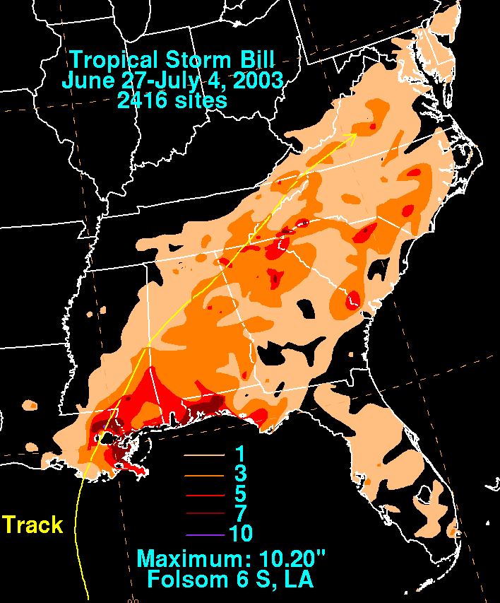
.gif)
Tropical Storm Bill (2003)
Encyclopedia
Tropical Storm Bill was a tropical storm that affected the Gulf Coast of the United States
in the summer of 2003. The second storm of the 2003 Atlantic hurricane season
, Bill developed from a tropical wave
on June 29 to the north of the Yucatán Peninsula
. It slowly organized as it moved northward, and reached a peak of 60 mph (95 km/h) shortly before making landfall in south-central Louisiana
. Bill quickly weakened over land, and as it accelerated to the northeast, moisture from the storm, combined with cold air from an approaching cold front
, produced an outbreak of 34 tornado
es. Bill became extratropical on July 2, and was absorbed by the cold front later that day.
Upon making landfall on Louisiana
, the storm produced a moderate storm surge
, causing tidal flood
ing. In a city in the northeastern portion of the state, the surge breached a levee
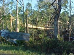
, which flooded many homes in the town. Moderate winds combined with wet soil
knocked down trees, which then hit a few houses and power lines, and left hundreds of thousands without electric power
. Two people drowned from rough surf
in Florida
. Further inland, tornadoes from the storm produced localized moderate damage. Throughout its path, Tropical Storm Bill caused around $50 million in damage (2003 USD
, $ USD) and four deaths.
developed scattered convection in the central Caribbean Sea
on June 24, while interacting with an upper-level low. It moved slowly northwestward, and remained disorganized due to strong upper level wind shear
. Late on June 27, the convection became slightly better organized around a broad low pressure area
, though land interaction prevented further development as it moved towards the Yucatán Peninsula
. The area of low pressure became better defined over the central Yucatán Peninsula, and after the system turned to the northwest, convection quickly organized while located over the warm waters of the Gulf of Mexico
. On June 29, following the development of a closed circulation, the system organized into Tropical Depression Three while located about 40 miles (60 km) north of Progreso, Yucatán
.
 The depression quickly strengthened to become Tropical Storm Bill
later on June 29. Operationally, the National Hurricane Center
did not begin issuing advisories until it attained tropical storm status. Initially, the system resembled a subtropical cyclone
, with the strongest winds and deep convection located far from the center, though it was classified tropical
due to its tropical origins. The storm steadily intensified as wind shear decreased, and early forecasts from the National Hurricane Center
mentioned the possibility of Bill intensifying to hurricane status
if the low level circulation organized beneath the area of deepest convection. Bill turned to the north-northwest, and later to the north, as it moved around the periphery of a ridge of high pressure
. On June 30, Tropical Storm Bill reached a peak intensity of 60 mph (95 km/h), one hour before making landfall
in southwestern Terrebonne Parish, Louisiana
. It moved onshore at peak intensity, and quickly weakened to a depression over land as it accelerated to the northeast. Bill remained a tropical cyclone as it moved through the southeast United States, until it became attached to an approaching cold front
on July 2 near the Tennessee
/Virginia
border. The remnant extratropical storm
was absorbed by the cold front on July 3 near central Virginia, while the remnant low pressure area continued northeastward until reaching the Atlantic Ocean
later on July 3.
issued a tropical storm watch from the southern end of Galveston Island
to Morgan City, Louisiana
. As a more northward motion occurred, the watch was canceled and replaced with a tropical storm warning from High Island, Texas
to Pascagoula, Mississippi
. Shortly before the storm made landfall, the warning was discontinued between High Island and Cameron, Louisiana
. The National Hurricane Center briefly issued a hurricane watch from Intracoastal City
to Morgan City, Louisiana
, but it was discontinued when Tropical Storm Bill failed to strengthen. Prior the storm making landfall, local National Weather Service
offices issued flash flood
watches and a tornado watch
for large portions of the Gulf Coast.
The threat of Tropical Storm Bill caused 41 oil platform
s and 11 oil rigs
to evacuate. This resulted in a loss of production of over 71 Toilbbl of oil and 610 million cufts (17,273,276.7 m³) of gas.
The American Red Cross
mobilized workers and brought food, water, and other supplies to Louisiana prior to the storm's arrival. At the request of Louisiana emergency management officials, the organization opened two shelters for residents in low-lying areas. Several floodgates in New Orleans
were closed before the storm made landfall, and many universities and government offices were closed as well. Parishes along the coastline closed summer camps and prepared sand bags, boats, and high-wheeled vehicles. Officials declared a voluntary evacuation for Grand Isle
, though few residents heeded the recommendation. Louisiana Governor Mike Foster
declared a statewide state of emergency
to easily make state resources available, and Mississippi
Governor Ronnie Musgrove
made a similar declaration for Harrison
, Hancock
, and Jackson Counties
, where shelters were also opened. Officials in Mississippi ordered the evacuation of flood-prone areas in anticipation for a moderate storm surge and above-normal tides.
es, ranking it fourteenth in the list of Atlantic hurricane
s generating the most tornadoes. The tornado outbreak was caused by wind shear
, moist air from the storm, and cool air from an approaching cold front
. In spite of the large numbers of tornadoes, most were weak and short-lived. Prior to forming, the storm produced rainfall along coastal areas of Mexico
along the Bay of Campeche
, peaking at nearly 4 inches (100 mm) in Yucatán
, and over 3 inches (75 mm) in Campeche
.
 The outer bands
of Bill dropped light rain across southeastern Texas
, peaking at 1.07 inches (27 mm) in Jamaica Beach
. Sustained winds from the storm remained weak, and peak wind gusts were 20 mph (32 km/h) in eastern Galveston County
. Upon making landfall, Bill caused a storm surge of up to 3.81 feet (1.1 m) at Pleasure Pier
. Effects in Texas were minimal, limited to minor beach erosion on the Bolivar Peninsula.
A moderate storm surge accompanied Tropical Storm Bill as it made landfall on Louisiana
. In the state, the maximum reported surge was 5.8 feet (1.8 m), and it occurred at the Louisiana Universities Marine Consortium facility in Chauvin
. In Montegut
, the surge breached a levee
still was damaged from the effects of Hurricane Lili
9 months before. The breach flooded many homes in the town, forcing the evacuation of an entire neighborhood. As a result, 150 homes in the town were damaged, with half of them severely. The storm surge affected numerous low-lying cities in southeastern Louisiana by flooding roadways, including the only road to Grand Isle
, stranding residents and visitors. The road was opened a day after the storm as floodwaters receded. The floodwaters entered a few homes and businesses in St. Tammany Parish
. Damage from the storm surge totaled to $4.1 million (2003 USD, $ USD). Rough waves sank two boats offshore, though their occupants were rescued.
The tornado
outbreak associated with the storm began with an F0
in St. Bernard Parish
that destroyed a boat house. A short-lived F1
tornado touched down in Reserve
, striking a private high school, where it destroyed one-half of one classroom and damaged several others. Later, the F1 tornado passed through a trailer park and severely damaged or destroyed 20 trailers. One trailer with a woman and three children was lifted into the air and dropped 30 feet (9.1 m) away; although all four occupants were injured none of them was wounded seriously. Damage from the tornado amounted to $2 million (2003 USD, $ USD). A third tornado, rated an F0, struck Orleans Parish, damaging a car and a portion of a roof.
Winds of 35 to 45 mph (55 to 70 km/h) were common across southeastern Louisiana, with the highest sustained wind being 53 mph (85 km/h) in Chauvin and a peak gust of 62 mph (100 km/h) on the northern end of the Lake Pontchartrain Causeway
. The winds knocked trees and tree branches into power lines, leaving 224,000 residents without power. The storm dropped moderate to heavy amounts of precipitation
, peaking at 10.2 inches (259 mm) at a location 6 miles (9.6 km) south of
Folsom
. The rainfall led to flash flood
ing, which inundated roads and cars and overwhelmed local drainage capacities. The rainfall also led to overflown rivers and creeks, resulting in flooding along the Tangipahoa River
in southern Tangipahoa Parish
, and the Bogue Falaya
and Tchefuncte River
in St. Tammany Parish. The Bogue Falaya River crested at 57 feet (17.4 m) on July 1, 12 feet (3.7 m) above flood stage
, which became a record for the recording station. The flooding damaged several structures and roadways. Less severe river flooding occurred in Washington
and Livingston Parishes
. In all, damage in Louisiana totaled to $44 million (2003 USD, $ USD).
of 4.99 feet (1.5 m) in Waveland, Mississippi
. The storm surge led to beach erosion, damage to piers, and flooded roadways, with damage from the surge amounting to around $1 million (2003 USD, $ USD). The maximum sustained wind from the storm recorded in Mississippi was 43 mph (69 km/h), at the Gulfport-Biloxi International Airport
, while the airport and Keesler Air Force Base
both reported a peak wind gust of 52 mph (84 km/h). Tropical Storm Bill dropped moderate to heavy rainfall across the state, peaking at 9.49 inches (241 mm) in Van Cleave
. The moderate wind gusts, along with the saturated
ground, downed trees in several locations. 34 roads in Pike
and Walthall Counties
were blocked by fallen trees, and two homes were damaged. Additionally, power outages were reported near the coast. The rainfall flooded streets in various portions of the state and led to overflown rivers. An overflown creek in Pearl River County
flooded structures and roadways. The outer rainbands of Bill produced a weak tornado that touched down briefly in Waveland, blowing down several trees which resulted in minor damage to roofs. Statewide damage accrued to $5 million (2003 USD, $ USD), primarily from flooding.
As Tropical Storm Bill made landfall on Louisiana, its effects were felt in the Alabama
coast as well, as heavy surf and tidal flooding pounded the coastline of the state. High waters closed a road to Dauphin Island and portions of a road along Mobile Bay
. Bill dropped over 3 inches (25 mm) of rain across the southern half of Alabama, with isolated locations receiving over 8 inches (205 mm). Due to wet conditions for months preceding the storm, rainfall from Bill led to flash flooding in many counties. The deluge led to overflown rivers and streams, and left several roadways temporarily impassable from high floodwaters. Saturated grounds and wind gusts of 30 to 35 mph (45 to 55 km/h) downed numerous trees. Many downed trees landed on power lines, which caused power outages for around 19,000 people. One downed tree destroyed a car, and another damaged a roof of a house. In Lee County
, a man was required to be rescued after driving through high flood waters. Roadway flooding resulted in a few minor traffic accidents. Also, the outer bands of the storm spawned an F1 tornado
in Crenshaw County
. Early in its path, it was narrow, and damage was limited to downed trees, two destroyed sheds, and a few houses experiencing light shingle damage or damage from fallen trees. Later, it expanded to reach a width of 1,800 feet (548 m) as it moved northwestward. The tornado destroyed the roofs of two houses, one of which experienced damage to its walls. The tornado dissipated eight minutes after its 3 mile (5 km) path began, resulting in $200,000 in damage (2003 USD, $ USD) and only slight injuries A second tornado, rated F0 in the Fujita scale
, occurred in southwestern Montgomery County
. A small tornado with a width of only 180 feet (55 m), it moved to the northwest and tore down a few trees that fell onto a mobile home, a house, and two cars. The tornado dissipated six minutes after its 5 mile (8 km) path began. Throughout Alabama, Tropical Storm Bill caused around $300,000 in damage (2003 USD, $ USD).
Rainfall from the storm began affecting Florida
a few days before the storm formed, and locations in the southern portion of the state received over 3 inches (75 mm) of rain. Along the Florida Panhandle
, Bill dropped over 8 inches (205 mm) of rain as it made landfall, closing several roads or leaving them impassable due to flooding. A stationary line of thunderstorms in Okaloosa County
produced downpours of up to 6 inches (150 mm) in one hour, resulting in flash flood
ing which washed out a portion of a bridge. In Bay County
, heavy rainfall and flooding damaged 40 homes, while several residents in an apartment in Parker
needed to be rescued by boat from the floodwaters. Rough surf produced by the storm killed two swimmers at Panama City Beach
, while a dozen had to be rescued. Part of the tornado outbreak spawned by the storm extended into northern Florida. Damage in Florida totaled to around $1 million (2003 USD, $ USD).
 Tropical Storm Bill dropped light rainfall of around 1 inch (25 mm) in northeastern Arkansas
and southeastern Missouri
, and over 5 inches (125 mm) in isolated parts of eastern Tennessee
. The storm also produced moderate rainfall in northwestern Georgia
, which peaked at 7.1 inches (180 mm) in Monroe
. Areas in southeastern Georgia received generally around 1 inch (25 mm), although some coastal areas did not receive any precipitation from the storm. Rainfall resulted in flooding in numerous locations around the Atlanta metropolitan area, leaving some roads impassable or closed. The combination of moist air from the south, cool temperatures from a cold front to the north, and low pressures led to the development of supercell
s throughout Georgia and South Carolina
, several of which produced tornadoes. An F1
tornado touched down 3 miles (5 km) north-northeast of Pennington; first it passed through a farm, causing severe damage to two dairy shed
s, a John Deere
tractor, and three metal storage buildings. The tornado destroyed a hay barn, a carport, and a car inside the carport as well, while also causing a tree to fall and kill one cow. The tornado passed through a forested area, where it toppled or sheared off hundreds of trees. As it entered a more urban area, it downed 30 isolated trees, some of which fell on a portion of Interstate 20
, temporarily closing the roadway. The tornado damaged seven houses, primarily to roof damage, although one experienced damage to several windows, while another had a utility trailer and a car damaged by fallen trees; a commercial building was damaged as well. An F2 tornado was reported in Clito, which knocked down trees and damaged mobile homes. Severe thunderstorms from the remnants of Bill caused considerable damage to a house near Louisville
and knocked down several trees. Moreover, a tornado was briefly associated with the storms. Bill also caused thunderstorms in Kite
which uprooted several trees onto a car and a house. One man in Atlanta
died due to a falling tree. Damage in Georgia totaled to $244,500 (2003 USD, $ USD).
 The tornado outbreak spawned by Bill was the greatest in the Charleston, South Carolina
National Weather Service
area since the outbreak provoked by Hurricane Earl
in 1998. One such tornado was an F1
that struck Hampton
, which uprooted trees and downed power lines. The tornado severely damaged a Dollar General
store, while several houses were damaged from fallen trees. An F1 tornado also touched down near Smoaks
, which uprooted several trees, resulted in a crush car due to a fallen tree, caused severe roof damage to a mobile home, and killed one dog. The storm produced heavy rainfall in the northern portion of the state, with some locations reporting over 7 inches (175 mm). The rainfall resulted in flash flooding in areas, which caused some damage.
In North Carolina
, the remnants of the storm dropped around 5 inches (125 mm) in the east-central part of the state, while the southwestern portion of the state received totals of over 7 inches (175 mm). In Raleigh
, a boy drowned from the floodwaters. The tornado outbreak from the storm extended into North Carolina, though specifics are unknown. Bill produced light to moderate precipitation in the Mid-Atlantic
, including over 5 inches (125 mm) in central Virginia
. In Virginia
, a line of thunderstorms from the system produced small amounts of hail in Falls Church
. The tornado outbreak associated with Bill ended in New Jersey; a narrow F0
tornado briefly touched down in a marsh near Goshen
. The tornado remained away from the city, and caused no damage or injuries.
circulated a petition for a class-action lawsuit in response to the levee failure. The American Red Cross
set up a church in Reserve
as an emergency shelter. Only five people stayed the first night, resulting in the organization to convert it to a family services center. Over 100 families asked for food assistance. The Red Cross also set up a shelter in Houma
, where 14 people stayed.
Gulf Coast of the United States
The Gulf Coast of the United States, sometimes referred to as the Gulf South, South Coast, or 3rd Coast, comprises the coasts of American states that are on the Gulf of Mexico, which includes Texas, Louisiana, Mississippi, Alabama, and Florida and are known as the Gulf States...
in the summer of 2003. The second storm of the 2003 Atlantic hurricane season
2003 Atlantic hurricane season
The 2003 Atlantic hurricane season was an active Atlantic hurricane season with tropical activity before and after the official bounds of the season – the first such occurrence in 50 years. The season produced 21 tropical cyclones, of which 16 developed into named storms; seven...
, Bill developed from a tropical wave
Tropical wave
Tropical waves, easterly waves, or tropical easterly waves, also known as African easterly waves in the Atlantic region, are a type of atmospheric trough, an elongated area of relatively low air pressure, oriented north to south, which move from east to west across the tropics causing areas of...
on June 29 to the north of the Yucatán Peninsula
Yucatán Peninsula
The Yucatán Peninsula, in southeastern Mexico, separates the Caribbean Sea from the Gulf of Mexico, with the northern coastline on the Yucatán Channel...
. It slowly organized as it moved northward, and reached a peak of 60 mph (95 km/h) shortly before making landfall in south-central Louisiana
Louisiana
Louisiana is a state located in the southern region of the United States of America. Its capital is Baton Rouge and largest city is New Orleans. Louisiana is the only state in the U.S. with political subdivisions termed parishes, which are local governments equivalent to counties...
. Bill quickly weakened over land, and as it accelerated to the northeast, moisture from the storm, combined with cold air from an approaching cold front
Surface weather analysis
Surface weather analysis is a special type of weather map that provides a view of weather elements over a geographical area at a specified time based on information from ground-based weather stations...
, produced an outbreak of 34 tornado
Tornado
A tornado is a violent, dangerous, rotating column of air that is in contact with both the surface of the earth and a cumulonimbus cloud or, in rare cases, the base of a cumulus cloud. They are often referred to as a twister or a cyclone, although the word cyclone is used in meteorology in a wider...
es. Bill became extratropical on July 2, and was absorbed by the cold front later that day.
Upon making landfall on Louisiana
Louisiana
Louisiana is a state located in the southern region of the United States of America. Its capital is Baton Rouge and largest city is New Orleans. Louisiana is the only state in the U.S. with political subdivisions termed parishes, which are local governments equivalent to counties...
, the storm produced a moderate storm surge
Storm surge
A storm surge is an offshore rise of water associated with a low pressure weather system, typically tropical cyclones and strong extratropical cyclones. Storm surges are caused primarily by high winds pushing on the ocean's surface. The wind causes the water to pile up higher than the ordinary sea...
, causing tidal flood
Flood
A flood is an overflow of an expanse of water that submerges land. The EU Floods directive defines a flood as a temporary covering by water of land not normally covered by water...
ing. In a city in the northeastern portion of the state, the surge breached a levee
Levee
A levee, levée, dike , embankment, floodbank or stopbank is an elongated naturally occurring ridge or artificially constructed fill or wall, which regulates water levels...
, which flooded many homes in the town. Moderate winds combined with wet soil
Soil
Soil is a natural body consisting of layers of mineral constituents of variable thicknesses, which differ from the parent materials in their morphological, physical, chemical, and mineralogical characteristics...
knocked down trees, which then hit a few houses and power lines, and left hundreds of thousands without electric power
Electric power
Electric power is the rate at which electric energy is transferred by an electric circuit. The SI unit of power is the watt.-Circuits:Electric power, like mechanical power, is represented by the letter P in electrical equations...
. Two people drowned from rough surf
Ocean surface wave
In fluid dynamics, wind waves or, more precisely, wind-generated waves are surface waves that occur on the free surface of oceans, seas, lakes, rivers, and canals or even on small puddles and ponds. They usually result from the wind blowing over a vast enough stretch of fluid surface. Waves in the...
in Florida
Florida
Florida is a state in the southeastern United States, located on the nation's Atlantic and Gulf coasts. It is bordered to the west by the Gulf of Mexico, to the north by Alabama and Georgia and to the east by the Atlantic Ocean. With a population of 18,801,310 as measured by the 2010 census, it...
. Further inland, tornadoes from the storm produced localized moderate damage. Throughout its path, Tropical Storm Bill caused around $50 million in damage (2003 USD
United States dollar
The United States dollar , also referred to as the American dollar, is the official currency of the United States of America. It is divided into 100 smaller units called cents or pennies....
, $ USD) and four deaths.
Meteorological history
A tropical waveTropical wave
Tropical waves, easterly waves, or tropical easterly waves, also known as African easterly waves in the Atlantic region, are a type of atmospheric trough, an elongated area of relatively low air pressure, oriented north to south, which move from east to west across the tropics causing areas of...
developed scattered convection in the central Caribbean Sea
Caribbean Sea
The Caribbean Sea is a sea of the Atlantic Ocean located in the tropics of the Western hemisphere. It is bounded by Mexico and Central America to the west and southwest, to the north by the Greater Antilles, and to the east by the Lesser Antilles....
on June 24, while interacting with an upper-level low. It moved slowly northwestward, and remained disorganized due to strong upper level wind shear
Wind shear
Wind shear, sometimes referred to as windshear or wind gradient, is a difference in wind speed and direction over a relatively short distance in the atmosphere...
. Late on June 27, the convection became slightly better organized around a broad low pressure area
Low pressure area
A low-pressure area, or "low", is a region where the atmospheric pressure at sea level is below that of surrounding locations. Low-pressure systems form under areas of wind divergence which occur in upper levels of the troposphere. The formation process of a low-pressure area is known as...
, though land interaction prevented further development as it moved towards the Yucatán Peninsula
Yucatán Peninsula
The Yucatán Peninsula, in southeastern Mexico, separates the Caribbean Sea from the Gulf of Mexico, with the northern coastline on the Yucatán Channel...
. The area of low pressure became better defined over the central Yucatán Peninsula, and after the system turned to the northwest, convection quickly organized while located over the warm waters of the Gulf of Mexico
Gulf of Mexico
The Gulf of Mexico is a partially landlocked ocean basin largely surrounded by the North American continent and the island of Cuba. It is bounded on the northeast, north and northwest by the Gulf Coast of the United States, on the southwest and south by Mexico, and on the southeast by Cuba. In...
. On June 29, following the development of a closed circulation, the system organized into Tropical Depression Three while located about 40 miles (60 km) north of Progreso, Yucatán
Progreso, Yucatán
Progreso is a port city in the Mexican state of Yucatán, located on the Gulf of Mexico in the north-west of the state some 30 minutes north of state capital Mérida by highway. As of the Mexican census of 2005, Progreso had an official population of 35,519 inhabitants, the fifth-largest community...
.
William (name)
William is a popular given name of old Germanic origin. It became very popular in the English language after the Norman conquest of England in 1066, and remained so throughout the Middle Ages and into the modern era...
later on June 29. Operationally, the National Hurricane Center
National Hurricane Center
The National Hurricane Center , located at Florida International University in Miami, Florida, is the division of the National Weather Service responsible for tracking and predicting weather systems within the tropics between the Prime Meridian and the 140th meridian west poleward to the 30th...
did not begin issuing advisories until it attained tropical storm status. Initially, the system resembled a subtropical cyclone
Subtropical cyclone
A subtropical cyclone is a weather system that has some characteristics of a tropical and an extratropical cyclone. As early as the 1950s, meteorologists were unclear whether they should be characterized as tropical or extratropical cyclones. They were officially recognized by the National...
, with the strongest winds and deep convection located far from the center, though it was classified tropical
Tropical cyclone
A tropical cyclone is a storm system characterized by a large low-pressure center and numerous thunderstorms that produce strong winds and heavy rain. Tropical cyclones strengthen when water evaporated from the ocean is released as the saturated air rises, resulting in condensation of water vapor...
due to its tropical origins. The storm steadily intensified as wind shear decreased, and early forecasts from the National Hurricane Center
National Hurricane Center
The National Hurricane Center , located at Florida International University in Miami, Florida, is the division of the National Weather Service responsible for tracking and predicting weather systems within the tropics between the Prime Meridian and the 140th meridian west poleward to the 30th...
mentioned the possibility of Bill intensifying to hurricane status
Saffir-Simpson Hurricane Scale
The Saffir–Simpson Hurricane Scale , or the Saffir–Simpson Hurricane Wind Scale , classifies hurricanes — Western Hemisphere tropical cyclones that exceed the intensities of tropical depressions and tropical storms — into five categories distinguished by the intensities of their sustained winds...
if the low level circulation organized beneath the area of deepest convection. Bill turned to the north-northwest, and later to the north, as it moved around the periphery of a ridge of high pressure
Ridge (meteorology)
A ridge is an elongated region of relatively high atmospheric pressure, the opposite of a trough....
. On June 30, Tropical Storm Bill reached a peak intensity of 60 mph (95 km/h), one hour before making landfall
Landfall (meteorology)
Landfall is the event of a tropical cyclone or a waterspout coming onto land after being over water. When a waterspout makes landfall it is reclassified as a tornado, which can then cause damage inland...
in southwestern Terrebonne Parish, Louisiana
Terrebonne Parish, Louisiana
Terrebonne Parish is a parish located in the U.S. state of Louisiana. The parish seat is Houma. Its population was 111,860...
. It moved onshore at peak intensity, and quickly weakened to a depression over land as it accelerated to the northeast. Bill remained a tropical cyclone as it moved through the southeast United States, until it became attached to an approaching cold front
Surface weather analysis
Surface weather analysis is a special type of weather map that provides a view of weather elements over a geographical area at a specified time based on information from ground-based weather stations...
on July 2 near the Tennessee
Tennessee
Tennessee is a U.S. state located in the Southeastern United States. It has a population of 6,346,105, making it the nation's 17th-largest state by population, and covers , making it the 36th-largest by total land area...
/Virginia
Virginia
The Commonwealth of Virginia , is a U.S. state on the Atlantic Coast of the Southern United States. Virginia is nicknamed the "Old Dominion" and sometimes the "Mother of Presidents" after the eight U.S. presidents born there...
border. The remnant extratropical storm
Extratropical cyclone
Extratropical cyclones, sometimes called mid-latitude cyclones or wave cyclones, are a group of cyclones defined as synoptic scale low pressure weather systems that occur in the middle latitudes of the Earth having neither tropical nor polar characteristics, and are connected with fronts and...
was absorbed by the cold front on July 3 near central Virginia, while the remnant low pressure area continued northeastward until reaching the Atlantic Ocean
Atlantic Ocean
The Atlantic Ocean is the second-largest of the world's oceanic divisions. With a total area of about , it covers approximately 20% of the Earth's surface and about 26% of its water surface area...
later on July 3.
Preparations
Shortly after forming, the National Hurricane CenterNational Hurricane Center
The National Hurricane Center , located at Florida International University in Miami, Florida, is the division of the National Weather Service responsible for tracking and predicting weather systems within the tropics between the Prime Meridian and the 140th meridian west poleward to the 30th...
issued a tropical storm watch from the southern end of Galveston Island
Galveston Island
Galveston Island is a barrier island on the Texas Gulf coast in the United States, about 50 miles southeast of Houston. The entire island, with the exception of Jamaica Beach, is within the city limits of the City of Galveston....
to Morgan City, Louisiana
Morgan City, Louisiana
Morgan City is a city in St. Martin and St. Mary parishes in the U.S. state of Louisiana. The population was 12,404 at the 2010 census....
. As a more northward motion occurred, the watch was canceled and replaced with a tropical storm warning from High Island, Texas
High Island, Texas
High Island is an unincorporated area located in the Bolivar Peninsula census-designated place, Galveston County, Texas, United States. The community is located in the extreme eastern part of the county on Bolivar Peninsula, less than one mile from Chambers County and less than two miles from...
to Pascagoula, Mississippi
Pascagoula, Mississippi
Pascagoula is a city in Jackson County, Mississippi, United States. It is the principal city of the Pascagoula, Mississippi Metropolitan Statistical Area, as a part of the Gulfport–Biloxi–Pascagoula, Mississippi Combined Statistical Area. The population was 26,200 at the 2000 census...
. Shortly before the storm made landfall, the warning was discontinued between High Island and Cameron, Louisiana
Cameron, Louisiana
Cameron is a census-designated place in and the parish seat of Cameron Parish, Louisiana, United States. The population was 1,965 at the 2000 census. It is part of the Lake Charles Metropolitan Statistical Area...
. The National Hurricane Center briefly issued a hurricane watch from Intracoastal City
Intracoastal City, Louisiana
Intracoastal City is an unincorporated community in Vermilion Parish, Louisiana, United States. It is situated on the west bank of the Vermilion River at its junction with the Gulf Intracoastal Waterway and has various port facilities and some permanent residents.Intracoastal City is approximately...
to Morgan City, Louisiana
Morgan City, Louisiana
Morgan City is a city in St. Martin and St. Mary parishes in the U.S. state of Louisiana. The population was 12,404 at the 2010 census....
, but it was discontinued when Tropical Storm Bill failed to strengthen. Prior the storm making landfall, local National Weather Service
National Weather Service
The National Weather Service , once known as the Weather Bureau, is one of the six scientific agencies that make up the National Oceanic and Atmospheric Administration of the United States government...
offices issued flash flood
Flash flood
A flash flood is a rapid flooding of geomorphic low-lying areas—washes, rivers, dry lakes and basins. It may be caused by heavy rain associated with a storm, hurricane, or tropical storm or meltwater from ice or snow flowing over ice sheets or snowfields...
watches and a tornado watch
Tornado watch
A tornado watch is issued when conditions are right for a tornado to form. Since any thunderstorm capable of producing a tornado is defined as severe, a tornado watch is also automatically a severe thunderstorm watch...
for large portions of the Gulf Coast.
The threat of Tropical Storm Bill caused 41 oil platform
Oil platform
An oil platform, also referred to as an offshore platform or, somewhat incorrectly, oil rig, is a lаrge structure with facilities to drill wells, to extract and process oil and natural gas, and to temporarily store product until it can be brought to shore for refining and marketing...
s and 11 oil rigs
Oil platform
An oil platform, also referred to as an offshore platform or, somewhat incorrectly, oil rig, is a lаrge structure with facilities to drill wells, to extract and process oil and natural gas, and to temporarily store product until it can be brought to shore for refining and marketing...
to evacuate. This resulted in a loss of production of over 71 Toilbbl of oil and 610 million cufts (17,273,276.7 m³) of gas.
The American Red Cross
American Red Cross
The American Red Cross , also known as the American National Red Cross, is a volunteer-led, humanitarian organization that provides emergency assistance, disaster relief and education inside the United States. It is the designated U.S...
mobilized workers and brought food, water, and other supplies to Louisiana prior to the storm's arrival. At the request of Louisiana emergency management officials, the organization opened two shelters for residents in low-lying areas. Several floodgates in New Orleans
New Orleans, Louisiana
New Orleans is a major United States port and the largest city and metropolitan area in the state of Louisiana. The New Orleans metropolitan area has a population of 1,235,650 as of 2009, the 46th largest in the USA. The New Orleans – Metairie – Bogalusa combined statistical area has a population...
were closed before the storm made landfall, and many universities and government offices were closed as well. Parishes along the coastline closed summer camps and prepared sand bags, boats, and high-wheeled vehicles. Officials declared a voluntary evacuation for Grand Isle
Grand Isle, Louisiana
Grand Isle is a town in Jefferson Parish, Louisiana, located on a barrier island of the same name in the Gulf of Mexico. The island is at the mouth of Barataria Bay where it meets the gulf. As of the 2000 census, the town population was 1,541; during summers, the population sometimes increases to...
, though few residents heeded the recommendation. Louisiana Governor Mike Foster
Murphy J. Foster, Jr.
Murphy James "Mike" Foster, Jr. served as 53rd Governor of Louisiana from January 1996 until January 2004. Foster's father was Murphy J. Foster, Jr., but Mike Foster uses "Jr." even though he is technically Murphy J. Foster, III. Foster is a businessman, landowner, and sportsman in St...
declared a statewide state of emergency
State of emergency
A state of emergency is a governmental declaration that may suspend some normal functions of the executive, legislative and judicial powers, alert citizens to change their normal behaviours, or order government agencies to implement emergency preparedness plans. It can also be used as a rationale...
to easily make state resources available, and Mississippi
Mississippi
Mississippi is a U.S. state located in the Southern United States. Jackson is the state capital and largest city. The name of the state derives from the Mississippi River, which flows along its western boundary, whose name comes from the Ojibwe word misi-ziibi...
Governor Ronnie Musgrove
Ronnie Musgrove
David Ronald "Ronnie" Musgrove is an American politician who was the 29th Lieutenant Governor of Mississippi from January 16, 1996 to January 11, 2000 and the 62nd Governor of Mississippi from January 11, 2000 to January 13, 2004 of the U.S. state of Mississippi. He was recently defeated by...
made a similar declaration for Harrison
Harrison County, Mississippi
-National protected areas:* De Soto National Forest * Gulf Islands National Seashore - Demographics :As of the census of 2000, there were 189,601 people, 71,538 households, and 48,574 families residing in the county. The population density was 326 people per square mile . There were 79,636 housing...
, Hancock
Hancock County, Mississippi
-Demographics:As of the census of 2000, there were 42,967 people, 16,897 households, and 11,827 families residing in the county. The population density was 90 people per square mile . There were 21,072 housing units at an average density of 44 per square mile...
, and Jackson Counties
Jackson County, Mississippi
There were 47,676 households out of which 37.00% had children under the age of 18 living with them, 55.70% were married couples living together, 14.50% had a female householder with no husband present, and 25.10% were non-families. 20.80% of all households were made up of individuals and 7.10% had...
, where shelters were also opened. Officials in Mississippi ordered the evacuation of flood-prone areas in anticipation for a moderate storm surge and above-normal tides.
Impact
Bill caused four direct deaths along its path, as well as minor to moderate damage. Damage estimates totaled to over $50 million (2003 USD, $55 million 2007 USD), primarily as a result of flooding or tornadic damage. Throughout its path, Bill spawned 34 tornadoTornado
A tornado is a violent, dangerous, rotating column of air that is in contact with both the surface of the earth and a cumulonimbus cloud or, in rare cases, the base of a cumulus cloud. They are often referred to as a twister or a cyclone, although the word cyclone is used in meteorology in a wider...
es, ranking it fourteenth in the list of Atlantic hurricane
Atlantic hurricane
North Atlantic tropical cyclones usually form in the northern hemisphere summer or fall. Tropical cyclones can be categorized by intensity. Tropical storms have one-minute maximum sustained winds of at least 39 mph , while hurricanes have one-minute maximum sustained exceeding 74 mph...
s generating the most tornadoes. The tornado outbreak was caused by wind shear
Wind shear
Wind shear, sometimes referred to as windshear or wind gradient, is a difference in wind speed and direction over a relatively short distance in the atmosphere...
, moist air from the storm, and cool air from an approaching cold front
Surface weather analysis
Surface weather analysis is a special type of weather map that provides a view of weather elements over a geographical area at a specified time based on information from ground-based weather stations...
. In spite of the large numbers of tornadoes, most were weak and short-lived. Prior to forming, the storm produced rainfall along coastal areas of Mexico
Mexico
The United Mexican States , commonly known as Mexico , is a federal constitutional republic in North America. It is bordered on the north by the United States; on the south and west by the Pacific Ocean; on the southeast by Guatemala, Belize, and the Caribbean Sea; and on the east by the Gulf of...
along the Bay of Campeche
Bay of Campeche
The Bay of Campeche is the southern bight of the Gulf of Mexico. It is surrounded on three sides by the Mexican states of Campeche, Tabasco and Veracruz. It was named by Francisco Hernández de Córdoba and Antonio de Alaminos during their expedition in 1517...
, peaking at nearly 4 inches (100 mm) in Yucatán
Yucatán
Yucatán officially Estado Libre y Soberano de Yucatán is one of the 31 states which, with the Federal District, comprise the 32 Federal Entities of Mexico. It is divided in 106 municipalities and its capital city is Mérida....
, and over 3 inches (75 mm) in Campeche
Campeche
Campeche is one of the 31 states which, with the Federal District, comprise the 32 Federal Entities of Mexico. Located in Southeast Mexico, it is bordered by the states of Yucatán to the north east, Quintana Roo to the east, and Tabasco to the south west...
.
Western Gulf Coast
Rainband
A rainband is a cloud and precipitation structure associated with an area of rainfall which is significantly elongated. Rainbands can be stratiform or convective, and are generated by differences in temperature. When noted on weather radar imagery, this precipitation elongation is referred to as...
of Bill dropped light rain across southeastern Texas
Texas
Texas is the second largest U.S. state by both area and population, and the largest state by area in the contiguous United States.The name, based on the Caddo word "Tejas" meaning "friends" or "allies", was applied by the Spanish to the Caddo themselves and to the region of their settlement in...
, peaking at 1.07 inches (27 mm) in Jamaica Beach
Jamaica Beach, Texas
Jamaica Beach is a city in Galveston County, Texas, United States. As of the 2000 census, the city population was 1,075.-History:Prior to its development, Jamaica Beach was a Karankawa burial ground. Johnny Goyen and Earl Galceran of the Jamaica Corporation developed Jamaica Beach as a 2,000-lot...
. Sustained winds from the storm remained weak, and peak wind gusts were 20 mph (32 km/h) in eastern Galveston County
Galveston County, Texas
Galveston County is a county located in the U.S. state of Texas within the Houston–Sugar Land–Baytown metropolitan area. As of the 2010 U.S. Census, the population was 291,309. Its county seat is Galveston. League City is the largest city in Galveston County in terms of population; between...
. Upon making landfall, Bill caused a storm surge of up to 3.81 feet (1.1 m) at Pleasure Pier
Galveston, Texas
Galveston is a coastal city located on Galveston Island in the U.S. state of Texas. , the city had a total population of 47,743 within an area of...
. Effects in Texas were minimal, limited to minor beach erosion on the Bolivar Peninsula.
A moderate storm surge accompanied Tropical Storm Bill as it made landfall on Louisiana
Louisiana
Louisiana is a state located in the southern region of the United States of America. Its capital is Baton Rouge and largest city is New Orleans. Louisiana is the only state in the U.S. with political subdivisions termed parishes, which are local governments equivalent to counties...
. In the state, the maximum reported surge was 5.8 feet (1.8 m), and it occurred at the Louisiana Universities Marine Consortium facility in Chauvin
Chauvin, Louisiana
Chauvin is a census-designated place in Terrebonne Parish, Louisiana, United States. The population was 3,229 at the 2000 census. It is part of the Houma–Bayou Cane–Thibodaux Metropolitan Statistical Area.-Geography:...
. In Montegut
Montegut, Louisiana
Montegut is a census-designated place in Terrebonne Parish, Louisiana, United States. The population was 1,803 at the 2000 census. It is part of the Houma–Bayou Cane–Thibodaux Metropolitan Statistical Area.-Geography:...
, the surge breached a levee
Levee
A levee, levée, dike , embankment, floodbank or stopbank is an elongated naturally occurring ridge or artificially constructed fill or wall, which regulates water levels...
still was damaged from the effects of Hurricane Lili
Hurricane Lili
Hurricane Lili was the deadliest and costliest hurricane of the 2002 Atlantic hurricane season for the United States. Lili was the twelfth named storm, fourth hurricane, and second major hurricane of the 2002 Atlantic hurricane season. The storm developed from a tropical disturbance in the open...
9 months before. The breach flooded many homes in the town, forcing the evacuation of an entire neighborhood. As a result, 150 homes in the town were damaged, with half of them severely. The storm surge affected numerous low-lying cities in southeastern Louisiana by flooding roadways, including the only road to Grand Isle
Grand Isle, Louisiana
Grand Isle is a town in Jefferson Parish, Louisiana, located on a barrier island of the same name in the Gulf of Mexico. The island is at the mouth of Barataria Bay where it meets the gulf. As of the 2000 census, the town population was 1,541; during summers, the population sometimes increases to...
, stranding residents and visitors. The road was opened a day after the storm as floodwaters receded. The floodwaters entered a few homes and businesses in St. Tammany Parish
St. Tammany Parish, Louisiana
St. Tammany Parish is a parish located in the U.S. state of Louisiana, in the New Orleans–Metairie–Kenner Metropolitan Statistical Area. The parish seat is Covington....
. Damage from the storm surge totaled to $4.1 million (2003 USD, $ USD). Rough waves sank two boats offshore, though their occupants were rescued.
The tornado
Tornado
A tornado is a violent, dangerous, rotating column of air that is in contact with both the surface of the earth and a cumulonimbus cloud or, in rare cases, the base of a cumulus cloud. They are often referred to as a twister or a cyclone, although the word cyclone is used in meteorology in a wider...
outbreak associated with the storm began with an F0
Fujita scale
The Fujita scale , or Fujita-Pearson scale, is a scale for rating tornado intensity, based primarily on the damage tornadoes inflict on human-built structures and vegetation...
in St. Bernard Parish
St. Bernard Parish, Louisiana
St. Bernard Parish is a parish located southeast of New Orleans in the U.S. state of Louisiana. The parish seat is Chalmette, the largest city in the parish. As of 2000, its population was 67,229. It has been ranked the fastest-growing county in the United States from 2007 to 2008 by the U.S....
that destroyed a boat house. A short-lived F1
Fujita scale
The Fujita scale , or Fujita-Pearson scale, is a scale for rating tornado intensity, based primarily on the damage tornadoes inflict on human-built structures and vegetation...
tornado touched down in Reserve
Reserve, Louisiana
Reserve is a census-designated place in St. John the Baptist Parish, Louisiana, United States, on the east bank of the Mississippi River. The population was 9,111 at the 2000 census...
, striking a private high school, where it destroyed one-half of one classroom and damaged several others. Later, the F1 tornado passed through a trailer park and severely damaged or destroyed 20 trailers. One trailer with a woman and three children was lifted into the air and dropped 30 feet (9.1 m) away; although all four occupants were injured none of them was wounded seriously. Damage from the tornado amounted to $2 million (2003 USD, $ USD). A third tornado, rated an F0, struck Orleans Parish, damaging a car and a portion of a roof.
Winds of 35 to 45 mph (55 to 70 km/h) were common across southeastern Louisiana, with the highest sustained wind being 53 mph (85 km/h) in Chauvin and a peak gust of 62 mph (100 km/h) on the northern end of the Lake Pontchartrain Causeway
Lake Pontchartrain Causeway
The Lake Pontchartrain Causeway, or the Causeway, consists of two parallel bridges crossing Lake Pontchartrain in southern Louisiana, United States. The longer of the two bridges is long...
. The winds knocked trees and tree branches into power lines, leaving 224,000 residents without power. The storm dropped moderate to heavy amounts of precipitation
Precipitation (meteorology)
In meteorology, precipitation In meteorology, precipitation In meteorology, precipitation (also known as one of the classes of hydrometeors, which are atmospheric water phenomena is any product of the condensation of atmospheric water vapor that falls under gravity. The main forms of precipitation...
, peaking at 10.2 inches (259 mm) at a location 6 miles (9.6 km) south of
Folsom
Folsom, Louisiana
Folsom is a village in St. Tammany Parish, Louisiana, United States. The population was 525 at the 2000 census. The town is named after the wife of Grover Cleveland, Frances Folsom...
. The rainfall led to flash flood
Flash flood
A flash flood is a rapid flooding of geomorphic low-lying areas—washes, rivers, dry lakes and basins. It may be caused by heavy rain associated with a storm, hurricane, or tropical storm or meltwater from ice or snow flowing over ice sheets or snowfields...
ing, which inundated roads and cars and overwhelmed local drainage capacities. The rainfall also led to overflown rivers and creeks, resulting in flooding along the Tangipahoa River
Tangipahoa River
The Tangipahoa River originates northwest of McComb in southwest Mississippi, and runs south through Lake Tangipahoa in Percy Quin State Park before passing into southeast Louisiana. Its mouth opens into the northwest region of Lake Pontchartrain....
in southern Tangipahoa Parish
Tangipahoa Parish, Louisiana
Tangipahoa Parish is a parish located in the U.S. state of Louisiana, one of the Florida Parishes. The parish seat is Amite City, but the major city is Hammond. As of 2006, the population was 113,137...
, and the Bogue Falaya
Bogue Falaya
The Bogue Falaya, also known as the Bogue Falaya River, is a river in southeastern Louisiana in the United States. It is a tributary of the Tchefuncte River, which flows to Lake Pontchartrain...
and Tchefuncte River
Tchefuncte River
The Tchefuncte River drains into Lake Pontchartrain in Louisiana in the United States. It is about long.In the 19th century it was an important commercial waterway, where building materials and other products of the North Shore of Lake Pontchartrain were loaded to be shipped across the Lake to...
in St. Tammany Parish. The Bogue Falaya River crested at 57 feet (17.4 m) on July 1, 12 feet (3.7 m) above flood stage
Flood stage
Flood stage is the level at which the surface of a river, creek, or other body of water has risen to a sufficient level to cause damage or affects use of man-made structures...
, which became a record for the recording station. The flooding damaged several structures and roadways. Less severe river flooding occurred in Washington
Washington Parish, Louisiana
Washington Parish is a parish located in the U.S. state of Louisiana. Its parish seat is Franklinton. In 2000, its population was 43,926....
and Livingston Parishes
Livingston Parish, Louisiana
Livingston Parish Is a parish located in the U.S. state of Louisiana. Its parish seat is Livingston. As of 2010, its population was 128,026....
. In all, damage in Louisiana totaled to $44 million (2003 USD, $ USD).
Eastern Gulf Coast
Upon making landfall, Bill produced a peak storm surgeStorm surge
A storm surge is an offshore rise of water associated with a low pressure weather system, typically tropical cyclones and strong extratropical cyclones. Storm surges are caused primarily by high winds pushing on the ocean's surface. The wind causes the water to pile up higher than the ordinary sea...
of 4.99 feet (1.5 m) in Waveland, Mississippi
Waveland, Mississippi
Waveland is a city located in Hancock County, Mississippi, on the Gulf of Mexico. It is part of the Gulfport–Biloxi, Mississippi Metropolitan Statistical Area. The City of Waveland was incorporated in 1972. As of the 2000 census, the city had a total population of 6,674...
. The storm surge led to beach erosion, damage to piers, and flooded roadways, with damage from the surge amounting to around $1 million (2003 USD, $ USD). The maximum sustained wind from the storm recorded in Mississippi was 43 mph (69 km/h), at the Gulfport-Biloxi International Airport
Gulfport-Biloxi International Airport
-Hurricane Katrina:The airport was closed for repairs following severe damage by Hurricane Katrina on August 29, 2005. On September 8, 2005, the airport reopened for commercial flights on Northwest Airlines to Memphis and other airlines quickly followed suit. On February 1, 2006, Gulfport-Biloxi...
, while the airport and Keesler Air Force Base
Keesler Air Force Base
Keesler Air Force Base is a United States Air Force base located in Biloxi, a city in Harrison County, Mississippi, United States. The base is named in honor of aviator 2d Lt Samuel Reeves Keesler, Jr., a Mississippi native killed in France in First World War.-Units:The base is home of...
both reported a peak wind gust of 52 mph (84 km/h). Tropical Storm Bill dropped moderate to heavy rainfall across the state, peaking at 9.49 inches (241 mm) in Van Cleave
Jackson County, Mississippi
There were 47,676 households out of which 37.00% had children under the age of 18 living with them, 55.70% were married couples living together, 14.50% had a female householder with no husband present, and 25.10% were non-families. 20.80% of all households were made up of individuals and 7.10% had...
. The moderate wind gusts, along with the saturated
Water content
Water content or moisture content is the quantity of water contained in a material, such as soil , rock, ceramics, fruit, or wood. Water content is used in a wide range of scientific and technical areas, and is expressed as a ratio, which can range from 0 to the value of the materials' porosity at...
ground, downed trees in several locations. 34 roads in Pike
Pike County, Mississippi
-Demographics:As of the census of 2000, there were 38,940 people, 14,792 households, and 10,502 families residing in the county. The population density was 95 people per square mile . There were 16,720 housing units at an average density of 41 per square mile...
and Walthall Counties
Walthall County, Mississippi
-Demographics:As of the census of 2000, there were 15,156 people, 5,571 households, and 4,111 families residing in the county. The population density was 38 people per square mile . There were 6,418 housing units at an average density of 16 per square mile...
were blocked by fallen trees, and two homes were damaged. Additionally, power outages were reported near the coast. The rainfall flooded streets in various portions of the state and led to overflown rivers. An overflown creek in Pearl River County
Pearl River County, Mississippi
-National protected areas:*Bogue Chitto National Wildlife Refuge *De Soto National Forest -Demographics:The census estimates of 2006 place the county population over 57,000 and place it among the 10 fastest growing counties in the U.S. As of the census of 2000, there were 48,621 people, 18,078...
flooded structures and roadways. The outer rainbands of Bill produced a weak tornado that touched down briefly in Waveland, blowing down several trees which resulted in minor damage to roofs. Statewide damage accrued to $5 million (2003 USD, $ USD), primarily from flooding.
As Tropical Storm Bill made landfall on Louisiana, its effects were felt in the Alabama
Alabama
Alabama is a state located in the southeastern region of the United States. It is bordered by Tennessee to the north, Georgia to the east, Florida and the Gulf of Mexico to the south, and Mississippi to the west. Alabama ranks 30th in total land area and ranks second in the size of its inland...
coast as well, as heavy surf and tidal flooding pounded the coastline of the state. High waters closed a road to Dauphin Island and portions of a road along Mobile Bay
Mobile Bay
Mobile Bay is an inlet of the Gulf of Mexico, lying within the state of Alabama in the United States. Its mouth is formed by the Fort Morgan Peninsula on the eastern side and Dauphin Island, a barrier island on the western side. The Mobile River and Tensaw River empty into the northern end of the...
. Bill dropped over 3 inches (25 mm) of rain across the southern half of Alabama, with isolated locations receiving over 8 inches (205 mm). Due to wet conditions for months preceding the storm, rainfall from Bill led to flash flooding in many counties. The deluge led to overflown rivers and streams, and left several roadways temporarily impassable from high floodwaters. Saturated grounds and wind gusts of 30 to 35 mph (45 to 55 km/h) downed numerous trees. Many downed trees landed on power lines, which caused power outages for around 19,000 people. One downed tree destroyed a car, and another damaged a roof of a house. In Lee County
Lee County, Alabama
Lee County is a county of the U.S. state of Alabama. It is named in honor of Robert E. Lee, commanding general of the Confederate Army. As of 2010 the population was 140,247. It is part of the Auburn, Alabama Metropolitan Area. The county seat is Opelika, and the largest city is Auburn...
, a man was required to be rescued after driving through high flood waters. Roadway flooding resulted in a few minor traffic accidents. Also, the outer bands of the storm spawned an F1 tornado
Fujita scale
The Fujita scale , or Fujita-Pearson scale, is a scale for rating tornado intensity, based primarily on the damage tornadoes inflict on human-built structures and vegetation...
in Crenshaw County
Crenshaw County, Alabama
Crenshaw County is a county of the U.S. state of Alabama. Its name is in honor of a judge, Anderson Crenshaw. As of 2010 the population was 13,906. Its county seat is Luverne.-Geography:...
. Early in its path, it was narrow, and damage was limited to downed trees, two destroyed sheds, and a few houses experiencing light shingle damage or damage from fallen trees. Later, it expanded to reach a width of 1,800 feet (548 m) as it moved northwestward. The tornado destroyed the roofs of two houses, one of which experienced damage to its walls. The tornado dissipated eight minutes after its 3 mile (5 km) path began, resulting in $200,000 in damage (2003 USD, $ USD) and only slight injuries A second tornado, rated F0 in the Fujita scale
Fujita scale
The Fujita scale , or Fujita-Pearson scale, is a scale for rating tornado intensity, based primarily on the damage tornadoes inflict on human-built structures and vegetation...
, occurred in southwestern Montgomery County
Montgomery County, Alabama
Montgomery County is a county in the U.S. state of Alabama. It is the most populous county in the Montgomery Metropolitan Statistical Area; its population in 2010 was 229,363 .- History :...
. A small tornado with a width of only 180 feet (55 m), it moved to the northwest and tore down a few trees that fell onto a mobile home, a house, and two cars. The tornado dissipated six minutes after its 5 mile (8 km) path began. Throughout Alabama, Tropical Storm Bill caused around $300,000 in damage (2003 USD, $ USD).
Rainfall from the storm began affecting Florida
Florida
Florida is a state in the southeastern United States, located on the nation's Atlantic and Gulf coasts. It is bordered to the west by the Gulf of Mexico, to the north by Alabama and Georgia and to the east by the Atlantic Ocean. With a population of 18,801,310 as measured by the 2010 census, it...
a few days before the storm formed, and locations in the southern portion of the state received over 3 inches (75 mm) of rain. Along the Florida Panhandle
Florida Panhandle
The Florida Panhandle, an informal, unofficial term for the northwestern part of Florida, is a strip of land roughly 200 miles long and 50 to 100 miles wide , lying between Alabama on the north and the west, Georgia also on the north, and the Gulf of Mexico to the south. Its eastern boundary is...
, Bill dropped over 8 inches (205 mm) of rain as it made landfall, closing several roads or leaving them impassable due to flooding. A stationary line of thunderstorms in Okaloosa County
Okaloosa County, Florida
Okaloosa County is a county located in the state of Florida. Located in northwest Florida, it extends from the Gulf of Mexico to the Alabama state line. As of the 2000 census, the population was 170,498. The U.S. Census Bureau 2005 estimate for the county is 182,172. The 2009 estimate for the...
produced downpours of up to 6 inches (150 mm) in one hour, resulting in flash flood
Flash flood
A flash flood is a rapid flooding of geomorphic low-lying areas—washes, rivers, dry lakes and basins. It may be caused by heavy rain associated with a storm, hurricane, or tropical storm or meltwater from ice or snow flowing over ice sheets or snowfields...
ing which washed out a portion of a bridge. In Bay County
Bay County, Florida
Bay County is a county located in the U.S. state of Florida. The U.S. Census Bureau 2006 estimate for the county is 163,505 . Its county seat is Panama City, Florida. The county is best known for its white sand beaches and crystal blue water, where large pods of dolphins swim year-round...
, heavy rainfall and flooding damaged 40 homes, while several residents in an apartment in Parker
Parker, Florida
Parker is a city in Bay County, Florida, United States. It is part of the Panama City–Lynn Haven–Panama City Beach Metropolitan Statistical Area.-Geography:Parker is located at ....
needed to be rescued by boat from the floodwaters. Rough surf produced by the storm killed two swimmers at Panama City Beach
Panama City Beach, Florida
Panama City Beach is a city in Bay County, Florida, United States, on the Gulf of Mexico coast. The city is often referred to under the umbrella term of "Panama City", despite being a distinct municipality from the older and larger inland Panama City to the east, making Panama City and Panama City...
, while a dozen had to be rescued. Part of the tornado outbreak spawned by the storm extended into northern Florida. Damage in Florida totaled to around $1 million (2003 USD, $ USD).
Southeastern U.S.
Arkansas
Arkansas is a state located in the southern region of the United States. Its name is an Algonquian name of the Quapaw Indians. Arkansas shares borders with six states , and its eastern border is largely defined by the Mississippi River...
and southeastern Missouri
Missouri
Missouri is a US state located in the Midwestern United States, bordered by Iowa, Illinois, Kentucky, Tennessee, Arkansas, Oklahoma, Kansas and Nebraska. With a 2010 population of 5,988,927, Missouri is the 18th most populous state in the nation and the fifth most populous in the Midwest. It...
, and over 5 inches (125 mm) in isolated parts of eastern Tennessee
Tennessee
Tennessee is a U.S. state located in the Southeastern United States. It has a population of 6,346,105, making it the nation's 17th-largest state by population, and covers , making it the 36th-largest by total land area...
. The storm also produced moderate rainfall in northwestern Georgia
Georgia (U.S. state)
Georgia is a state located in the southeastern United States. It was established in 1732, the last of the original Thirteen Colonies. The state is named after King George II of Great Britain. Georgia was the fourth state to ratify the United States Constitution, on January 2, 1788...
, which peaked at 7.1 inches (180 mm) in Monroe
Monroe, Georgia
Monroe is a city in Walton County, Georgia, United States. The population was 13,381 at the 2008 census. The city is the county seat of Walton County, Georgia.-Geography:Monroe is located at ....
. Areas in southeastern Georgia received generally around 1 inch (25 mm), although some coastal areas did not receive any precipitation from the storm. Rainfall resulted in flooding in numerous locations around the Atlanta metropolitan area, leaving some roads impassable or closed. The combination of moist air from the south, cool temperatures from a cold front to the north, and low pressures led to the development of supercell
Supercell
A supercell is a thunderstorm that is characterized by the presence of a mesocyclone: a deep, continuously-rotating updraft. For this reason, these storms are sometimes referred to as rotating thunderstorms...
s throughout Georgia and South Carolina
South Carolina
South Carolina is a state in the Deep South of the United States that borders Georgia to the south, North Carolina to the north, and the Atlantic Ocean to the east. Originally part of the Province of Carolina, the Province of South Carolina was one of the 13 colonies that declared independence...
, several of which produced tornadoes. An F1
Fujita scale
The Fujita scale , or Fujita-Pearson scale, is a scale for rating tornado intensity, based primarily on the damage tornadoes inflict on human-built structures and vegetation...
tornado touched down 3 miles (5 km) north-northeast of Pennington; first it passed through a farm, causing severe damage to two dairy shed
Shed
A shed is typically a simple, single-storey structure in a back garden or on an allotment that is used for storage, hobbies, or as a workshop....
s, a John Deere
John Deere
John Deere was an American blacksmith and manufacturer who founded Deere & Company, one of the largest and leading agricultural and construction equipment manufacturers in the world...
tractor, and three metal storage buildings. The tornado destroyed a hay barn, a carport, and a car inside the carport as well, while also causing a tree to fall and kill one cow. The tornado passed through a forested area, where it toppled or sheared off hundreds of trees. As it entered a more urban area, it downed 30 isolated trees, some of which fell on a portion of Interstate 20
Interstate 20
Interstate 20 is a major east–west Interstate Highway in the Southern United States. I‑20 runs 1,535 miles from near Kent, Texas, at Interstate 10 to Florence, South Carolina, at Interstate 95...
, temporarily closing the roadway. The tornado damaged seven houses, primarily to roof damage, although one experienced damage to several windows, while another had a utility trailer and a car damaged by fallen trees; a commercial building was damaged as well. An F2 tornado was reported in Clito, which knocked down trees and damaged mobile homes. Severe thunderstorms from the remnants of Bill caused considerable damage to a house near Louisville
Louisville, Georgia
Louisville is a city in Jefferson County, Georgia, United States. It is the former capital of Georgia and is the county seat of Jefferson County. It is located southwest of Augusta on the Ogeechee River, and its population was 2,712 at the 2000 census. The local pronunciation is the Americanized...
and knocked down several trees. Moreover, a tornado was briefly associated with the storms. Bill also caused thunderstorms in Kite
Kite, Georgia
Kite is a town in Johnson County, Georgia, USA, along the Little Ohoopee River. The town was named after Shaderick Kight, who donated the land to build the town. He requested the simpler spelling of the name for more efficient mail delivery and processing. The population was 241 at the 2000 census...
which uprooted several trees onto a car and a house. One man in Atlanta
Atlanta, Georgia
Atlanta is the capital and most populous city in the U.S. state of Georgia. According to the 2010 census, Atlanta's population is 420,003. Atlanta is the cultural and economic center of the Atlanta metropolitan area, which is home to 5,268,860 people and is the ninth largest metropolitan area in...
died due to a falling tree. Damage in Georgia totaled to $244,500 (2003 USD, $ USD).
Charleston, South Carolina
Charleston is the second largest city in the U.S. state of South Carolina. It was made the county seat of Charleston County in 1901 when Charleston County was founded. The city's original name was Charles Towne in 1670, and it moved to its present location from a location on the west bank of the...
National Weather Service
National Weather Service
The National Weather Service , once known as the Weather Bureau, is one of the six scientific agencies that make up the National Oceanic and Atmospheric Administration of the United States government...
area since the outbreak provoked by Hurricane Earl
Hurricane Earl (1998)
Hurricane Earl was an atypical, short-lived Category 2 hurricane that caused moderate damage throughout the Southeast United States. It formed out of a poorly organized tropical disturbance over the southwest Gulf of Mexico late on August 31, 1998...
in 1998. One such tornado was an F1
Fujita scale
The Fujita scale , or Fujita-Pearson scale, is a scale for rating tornado intensity, based primarily on the damage tornadoes inflict on human-built structures and vegetation...
that struck Hampton
Hampton, South Carolina
Hampton is a town in Hampton County, South Carolina, United States. The population was 2,837 at the 2000 census. It is the county seat of Hampton County.-Geography:Hampton is located at ....
, which uprooted trees and downed power lines. The tornado severely damaged a Dollar General
Dollar General
Dollar General Corp. is a U.S. chain of variety stores headquartered in Goodlettsville, Tennessee. As of January 2011, Dollar General operated over 9,300 stores in 35 U.S. states....
store, while several houses were damaged from fallen trees. An F1 tornado also touched down near Smoaks
Smoaks, South Carolina
Smoaks is a town in Colleton County, South Carolina, United States. The population was 140 at the 2000 census.-Geography:Smoaks is located at .According to the United States Census Bureau, the town has a total area of , all of it land.-Demographics:...
, which uprooted several trees, resulted in a crush car due to a fallen tree, caused severe roof damage to a mobile home, and killed one dog. The storm produced heavy rainfall in the northern portion of the state, with some locations reporting over 7 inches (175 mm). The rainfall resulted in flash flooding in areas, which caused some damage.
In North Carolina
North Carolina
North Carolina is a state located in the southeastern United States. The state borders South Carolina and Georgia to the south, Tennessee to the west and Virginia to the north. North Carolina contains 100 counties. Its capital is Raleigh, and its largest city is Charlotte...
, the remnants of the storm dropped around 5 inches (125 mm) in the east-central part of the state, while the southwestern portion of the state received totals of over 7 inches (175 mm). In Raleigh
Raleigh, North Carolina
Raleigh is the capital and the second largest city in the state of North Carolina as well as the seat of Wake County. Raleigh is known as the "City of Oaks" for its many oak trees. According to the U.S. Census Bureau, the city's 2010 population was 403,892, over an area of , making Raleigh...
, a boy drowned from the floodwaters. The tornado outbreak from the storm extended into North Carolina, though specifics are unknown. Bill produced light to moderate precipitation in the Mid-Atlantic
Mid-Atlantic States
The Mid-Atlantic states, also called middle Atlantic states or simply the mid Atlantic, form a region of the United States generally located between New England and the South...
, including over 5 inches (125 mm) in central Virginia
Virginia
The Commonwealth of Virginia , is a U.S. state on the Atlantic Coast of the Southern United States. Virginia is nicknamed the "Old Dominion" and sometimes the "Mother of Presidents" after the eight U.S. presidents born there...
. In Virginia
Virginia
The Commonwealth of Virginia , is a U.S. state on the Atlantic Coast of the Southern United States. Virginia is nicknamed the "Old Dominion" and sometimes the "Mother of Presidents" after the eight U.S. presidents born there...
, a line of thunderstorms from the system produced small amounts of hail in Falls Church
Falls Church, Virginia
The City of Falls Church is an independent city in Virginia, United States, in the Washington Metropolitan Area. The city population was 12,332 in 2010, up from 10,377 in 2000. Taking its name from The Falls Church, an 18th-century Anglican parish, Falls Church gained township status within...
. The tornado outbreak associated with Bill ended in New Jersey; a narrow F0
Fujita scale
The Fujita scale , or Fujita-Pearson scale, is a scale for rating tornado intensity, based primarily on the damage tornadoes inflict on human-built structures and vegetation...
tornado briefly touched down in a marsh near Goshen
Goshen, New Jersey
Goshen is an unincorporated community in Cape May County, New Jersey, United States . Route 47, also known as Delsea Drive, runs directly through the center of the community....
. The tornado remained away from the city, and caused no damage or injuries.
Aftermath
By one day after the storm, power companies restored electricity to 151,000 customers. Citizens in MontegutMontegut, Louisiana
Montegut is a census-designated place in Terrebonne Parish, Louisiana, United States. The population was 1,803 at the 2000 census. It is part of the Houma–Bayou Cane–Thibodaux Metropolitan Statistical Area.-Geography:...
circulated a petition for a class-action lawsuit in response to the levee failure. The American Red Cross
American Red Cross
The American Red Cross , also known as the American National Red Cross, is a volunteer-led, humanitarian organization that provides emergency assistance, disaster relief and education inside the United States. It is the designated U.S...
set up a church in Reserve
Reserve, Louisiana
Reserve is a census-designated place in St. John the Baptist Parish, Louisiana, United States, on the east bank of the Mississippi River. The population was 9,111 at the 2000 census...
as an emergency shelter. Only five people stayed the first night, resulting in the organization to convert it to a family services center. Over 100 families asked for food assistance. The Red Cross also set up a shelter in Houma
Houma, Louisiana
Houma is a city in and the parish seat of Terrebonne Parish, Louisiana, and the largest principal city of the Houma–Bayou Cane–Thibodaux Metropolitan Statistical Area. The city's powers of government have been absorbed by the parish, which is now run by the Terrebonne Parish...
, where 14 people stayed.
See also
- Other storms of the same name
- List of Florida hurricanes (2000–present)
- List of North Carolina hurricanes (1980–present)