
.gif)
Tropical Storm Barry (2001)
Encyclopedia
Tropical Storm Barry was a strong tropical storm
that made landfall on the Florida
Panhandle
during August 2001. The third tropical cyclone and second named storm of the 2001 Atlantic hurricane season
, Barry developed from a tropical wave
that moved off the coast of Africa
on July 24 and tracked westward. The wave entered the Caribbean
on July 29 and spawned a low pressure area
that organized into Tropical Storm Barry on August 3. After fluctuations in intensity and track, the system attained peak winds of 70 mph (112.7 km/h) in the Gulf of Mexico
, and headed northward before moving ashore on the Gulf Coast.
Unlike the devastating Tropical Storm Allison
earlier in the season, Barry's effects were moderate. Nine deaths occurred, six in Cuba
and three in Florida
. As a tropical cyclone, rainfall peaked at 8.9 in (226.1 mm) at Tallahassee
, and winds gusts topped out at 79 mph (127.1 km/h). The wave that would become Barry dropped large amounts of rain across southern Florida, which led to significant flooding and structural damage. Moderate flooding occurred throughout the Panhandle, where damage was also reported as a result of high wind gusts. As the storm's remnants tracked inland, parts of the Mississippi Valley received light precipitation. Barry is estimated to have caused $30 million (2001 USD, $36.5 million 2008 USD) in damage.
emerged off the west coast of Africa
, and tracked westward across the Atlantic Ocean
. Little development occurred until July 28, when convective activity began to increase. The wave moved into the eastern Caribbean
on July 29, and while tracking west-northwest convection
continued to increase over the next few days. The disturbance emerged into the Gulf of Mexico
on August 1, with associated rainfall over southern Florida
and the western tip of Cuba
. A broad low pressure system with a minimum central pressure of 1014 mb developed along the wave near the Dry Tortugas
, at the end of the Florida Keys, that same day, and began to intensify as it moved northwestward. At around 1800 UTC on August 2, an Air Force Reserve Hurricane Hunter aircraft investigated the system and discovered that the low had organized into Tropical Storm Barry. The low developed into a tropical depression six hours earlier, as revealed by post-season analysis. There is uncertainty as to whether the storm actually held tropical characteristics at the time of designation because an upper-level low was situated over the surface center.
Upon becoming a tropical cyclone
, convection wrapped around roughly half of the center. Outflow in the eastern semicircle was good, although due to upper-level wind shear
, it was restricted to southeast of the circulation. The cyclone became embedded within a mid- to-upper-level trough
between the ridge over the central U.S. and the ridge over the northwestern Caribbean. A strong, upper-level cyclonic shear axis extended from just south of Cape Hatteras
to near Brownsville, Texas
, which prevented Barry from accelerating in forward speed. The ridge over the United States
weakened, thus collapsing the steering pattern; this resulted in a west-southwestward drifting motion of the tropical storm by around August 3. Early on August 3, strong westerly winds prevailed, and separated the center of circulation from what limited convection remained. The storm quickly regained some convection, although maximum sustained wind
s remained weak, at about 40 mph (60 km/h). Despite a slight drop in barometric pressure, post-season analysis revealed Barry weakened into a tropical depression early on August 4 due to the persistent wind shear and falling external pressure.
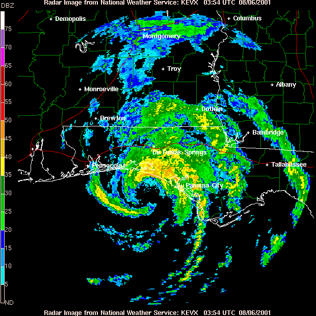
At 1800 UTC on August 4 the cyclone re-intensified slightly, and was upgraded to a tropical storm as the shear decreased. Early on August 5, a strengthening period began as deep convection ignited over and near the low-level center. Prior to landfall, banding features developed on the eastern half of the circulation, despite some residual westerly shear. Within seven hours the barometric pressure dropped from 1004 mb to 990 mb and overall satellite presentation had begun to improve. Barry reached its peak intensity at 1800 UTC on August 5 with winds of 70 mph (112.7 km/h), just shy of hurricane status. An eye
formed at around the same time. At 0500 UTC on August 6, Barry increased in forward speed and made landfall at Santa Rosa Beach, Florida with winds of 70 mph (112.7 km/h). Moving inland, the system weakened rapidly to a tropical depression; the National Hurricane Center
issued its last advisory on the storm early on August 6. By the evening hours, maximum sustained winds near the center were around 5 mph (8 km/h) to 10 mph (16.1 km/h) as the system slowed significantly and drifted northwest at about 7 mph (11.3 km/h). The depression turned northwestward, and steadily weakened to a remnant low near Memphis, Tennessee
on August 7, and the low dissipated on August 8 over southeastern Missouri
.
 In advance of the storm, the National Hurricane Center issued tropical storm watches and warnings for much of the U.S. Gulf Coast. They were upgraded to a hurricane warning when the storm was predicted to reach hurricane intensity. Because that strengthening failed to occur, the hurricane warning was downgraded to a tropical storm warning shortly before landfall. Westward, the warnings for Louisiana
and Mississippi
were discontinued. After Tropical Storm Barry made landfall, all tropical storm warnings for the Florida Panhandle were discontinued. Flood warnings were issued for parts of Leon
and Wakulla
counties, while a flash flood watch was in effect for parts of southern Georgia
. A tornado watch was issued for the eastern Florida Panhandle, southern Georgia, as well as portions of central and eastern Alabama.
As Barry approached the Florida Panhandle, voluntary evacuations took place in eight counties. Shelters opened in six counties, though most were placed on standby. In parts of Franklin County
, mandatory evacuations were ordered, and in Okaloosa County
, tolls on the Mid-Bay Bridge were suspended. Forty C-130
cargo aircraft and about 300 personnel from Hurlburt Field
were moved to the Little Rock Air Force Base
in Arkansas
to flee the storm's projected path. In Tallahassee
, county officials filled sandbags in areas vulnerable to flooding. At Grand Isle State Park
, Park Rangers moved picnic tables out of tidal range and closed the camping grounds for a period of time. Additionally, the storm forced NASA
to delay a shuttle launch in southern Florida. Elsewhere, thousands of personnel were evacuated from several offshore oil platforms. The city of New Orleans
closed 60 of its 72 floodgates to avoid possible flooding. Throughout southeastern Louisiana, including New Orleans, roughly 500 Red Cross volunteers and staff members were on standby. The threat of the storm forced the cancellation of an 'N Sync
concert at Pro Player Stadium.
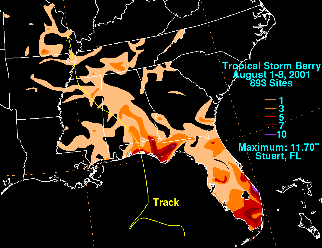
Three people in Florida were killed by the storm, and total damage is estimated at around $30 million (2001 USD, $36.5 million 2008 USD). In southern Florida, the precursor to Barry produced 3 in (75 mm) to 8 in (203.2 mm), with rainfall peaking at 13 in (330.2 mm). The rain helped relieve persistent drought
conditions, though it caused significant flooding in Martin County
on August 2, where a total of 300 homes received water damage. About 63 structures and 6 mobile homes in the county sustained major damage. In the Treasure Coast, catfish
reportedly swam through flooded streets. Winds downed a 60 ft (18.3 m) radio tower, striking a house.
Due to the initial slow movement of the storm, outer rain bands began affecting the Florida Panhandle on August 4, with the heaviest rainfall observed on August 5 – August 6. The storm dropped 5 in (125 mm) to 9 in (225 mm); the highest official report was 8.9 in (226.1 mm) at Tallahassee, though unofficial reports ranged as high as 11 in (175 mm). The rainfall inundated several structures in Bay County
due to roof damage. Flooding occurred in Leon County and parts of Apalachicola National Forest
, where torrential rains flowed into the Cascade Lakes
, Lake Bradford and Munson Slough; the Munson Slough rose to its highest level since 1994. Numerous county and secondary roads were closed by floodwater in Walton
, Washington
, and Bay counties, as well as in the Tallahassee area. In and around Tallahassee, 100 vehicles were stalled by flood waters and towed, while four residents of an apartment complex on Allen Road were forced to evacuate due to rising waters. Sporadic flooding also occurred in Franklin County
and Wakulla County
. An indirect death occurred from a traffic accident due to heavy rain in Jackson County
.
Wind gusts peaked at 79 mph (127.1 km/h) at the Eglin Air Force Base
Range Station C-72. Light to moderate winds were widespread, causing damage throughout Walton, Washington, Bay, Calhoun
, Gulf
and Okaloosa
counties. Trees were downed or damaged, and several structures suffered light wind damage. Window damage was reported at a high-rise condominium building in Destin
, while nearby, the Mid-Bay Bridge was closed due to high winds. The Freeport Elementary School in Walton County sustained minor roof damage. Storm surge was generally light, ranging from 2 ft (0.6096 m) to 3 ft (0.9144 m), with only minor beach erosion as a result. As a tropical system, Barry spawned a few weak tornadoes that caused minor damage. In an outer rain band, a lightning
strike in Jacksonville
killed one person. Another death is blamed on a rip current off of Sanibel Island. In total, the storm left 34,000 customers in the state without power.
, topping out at 4.57 in (116.1 mm), near the town of Evergreen
. About 2 in (50 mm) fell over the state's peanut
-growing region, helping to alleviate drought
conditions. Heavy showers were also reported in the Birmingham
area. Despite moderate rainfall totals inland, coastal locations received very little precipitation. Minor street flooding occurred in Geneva
, Enterprise
and New Brockton
. Wind gusts peaked at 39 mph (62.8 km/h) at Montgomery
, although damage was light, mostly from downed trees. Damage to awnings and small structures was reported in Florala
. Barry's remnants produced light rainfall across Mississippi
and Georgia
, though no damage was reported. As the storm continued to track inland, it dropped up to 3 in (75 mm) of rain throughout Arkansas
, Missouri
and western Tennessee
.
Tropical cyclone
A tropical cyclone is a storm system characterized by a large low-pressure center and numerous thunderstorms that produce strong winds and heavy rain. Tropical cyclones strengthen when water evaporated from the ocean is released as the saturated air rises, resulting in condensation of water vapor...
that made landfall on the Florida
Florida
Florida is a state in the southeastern United States, located on the nation's Atlantic and Gulf coasts. It is bordered to the west by the Gulf of Mexico, to the north by Alabama and Georgia and to the east by the Atlantic Ocean. With a population of 18,801,310 as measured by the 2010 census, it...
Panhandle
Florida Panhandle
The Florida Panhandle, an informal, unofficial term for the northwestern part of Florida, is a strip of land roughly 200 miles long and 50 to 100 miles wide , lying between Alabama on the north and the west, Georgia also on the north, and the Gulf of Mexico to the south. Its eastern boundary is...
during August 2001. The third tropical cyclone and second named storm of the 2001 Atlantic hurricane season
2001 Atlantic hurricane season
The 2001 Atlantic hurricane season was a fairly active Atlantic hurricane season that produced 17 tropical cyclones, 15 named storms, nine hurricanes, and four major hurricanes. The season officially lasted from June 1, 2001, to November 30, 2001, dates which by convention limit the period of each...
, Barry developed from a tropical wave
Tropical wave
Tropical waves, easterly waves, or tropical easterly waves, also known as African easterly waves in the Atlantic region, are a type of atmospheric trough, an elongated area of relatively low air pressure, oriented north to south, which move from east to west across the tropics causing areas of...
that moved off the coast of Africa
Africa
Africa is the world's second largest and second most populous continent, after Asia. At about 30.2 million km² including adjacent islands, it covers 6% of the Earth's total surface area and 20.4% of the total land area...
on July 24 and tracked westward. The wave entered the Caribbean
Caribbean
The Caribbean is a crescent-shaped group of islands more than 2,000 miles long separating the Gulf of Mexico and the Caribbean Sea, to the west and south, from the Atlantic Ocean, to the east and north...
on July 29 and spawned a low pressure area
Low pressure area
A low-pressure area, or "low", is a region where the atmospheric pressure at sea level is below that of surrounding locations. Low-pressure systems form under areas of wind divergence which occur in upper levels of the troposphere. The formation process of a low-pressure area is known as...
that organized into Tropical Storm Barry on August 3. After fluctuations in intensity and track, the system attained peak winds of 70 mph (112.7 km/h) in the Gulf of Mexico
Gulf of Mexico
The Gulf of Mexico is a partially landlocked ocean basin largely surrounded by the North American continent and the island of Cuba. It is bounded on the northeast, north and northwest by the Gulf Coast of the United States, on the southwest and south by Mexico, and on the southeast by Cuba. In...
, and headed northward before moving ashore on the Gulf Coast.
Unlike the devastating Tropical Storm Allison
Tropical Storm Allison
Tropical Storm Allison was a tropical storm that devastated southeast Texas in June of the 2001 Atlantic hurricane season. The first storm of the season, Allison lasted an unusually long period of time for a June storm, remaining tropical or subtropical for 15 days...
earlier in the season, Barry's effects were moderate. Nine deaths occurred, six in Cuba
Cuba
The Republic of Cuba is an island nation in the Caribbean. The nation of Cuba consists of the main island of Cuba, the Isla de la Juventud, and several archipelagos. Havana is the largest city in Cuba and the country's capital. Santiago de Cuba is the second largest city...
and three in Florida
Florida
Florida is a state in the southeastern United States, located on the nation's Atlantic and Gulf coasts. It is bordered to the west by the Gulf of Mexico, to the north by Alabama and Georgia and to the east by the Atlantic Ocean. With a population of 18,801,310 as measured by the 2010 census, it...
. As a tropical cyclone, rainfall peaked at 8.9 in (226.1 mm) at Tallahassee
Tallahassee, Florida
Tallahassee is the capital of the U.S. state of Florida. It is the county seat and only incorporated municipality in Leon County, and is the 128th largest city in the United States. Tallahassee became the capital of Florida, then the Florida Territory, in 1824. In 2010, the population recorded by...
, and winds gusts topped out at 79 mph (127.1 km/h). The wave that would become Barry dropped large amounts of rain across southern Florida, which led to significant flooding and structural damage. Moderate flooding occurred throughout the Panhandle, where damage was also reported as a result of high wind gusts. As the storm's remnants tracked inland, parts of the Mississippi Valley received light precipitation. Barry is estimated to have caused $30 million (2001 USD, $36.5 million 2008 USD) in damage.
Meteorological history
On July 24, 2001, a tropical waveTropical wave
Tropical waves, easterly waves, or tropical easterly waves, also known as African easterly waves in the Atlantic region, are a type of atmospheric trough, an elongated area of relatively low air pressure, oriented north to south, which move from east to west across the tropics causing areas of...
emerged off the west coast of Africa
Africa
Africa is the world's second largest and second most populous continent, after Asia. At about 30.2 million km² including adjacent islands, it covers 6% of the Earth's total surface area and 20.4% of the total land area...
, and tracked westward across the Atlantic Ocean
Atlantic Ocean
The Atlantic Ocean is the second-largest of the world's oceanic divisions. With a total area of about , it covers approximately 20% of the Earth's surface and about 26% of its water surface area...
. Little development occurred until July 28, when convective activity began to increase. The wave moved into the eastern Caribbean
Caribbean
The Caribbean is a crescent-shaped group of islands more than 2,000 miles long separating the Gulf of Mexico and the Caribbean Sea, to the west and south, from the Atlantic Ocean, to the east and north...
on July 29, and while tracking west-northwest convection
Convection
Convection is the movement of molecules within fluids and rheids. It cannot take place in solids, since neither bulk current flows nor significant diffusion can take place in solids....
continued to increase over the next few days. The disturbance emerged into the Gulf of Mexico
Gulf of Mexico
The Gulf of Mexico is a partially landlocked ocean basin largely surrounded by the North American continent and the island of Cuba. It is bounded on the northeast, north and northwest by the Gulf Coast of the United States, on the southwest and south by Mexico, and on the southeast by Cuba. In...
on August 1, with associated rainfall over southern Florida
Florida
Florida is a state in the southeastern United States, located on the nation's Atlantic and Gulf coasts. It is bordered to the west by the Gulf of Mexico, to the north by Alabama and Georgia and to the east by the Atlantic Ocean. With a population of 18,801,310 as measured by the 2010 census, it...
and the western tip of Cuba
Cuba
The Republic of Cuba is an island nation in the Caribbean. The nation of Cuba consists of the main island of Cuba, the Isla de la Juventud, and several archipelagos. Havana is the largest city in Cuba and the country's capital. Santiago de Cuba is the second largest city...
. A broad low pressure system with a minimum central pressure of 1014 mb developed along the wave near the Dry Tortugas
Dry Tortugas
The Dry Tortugas are a small group of islands, located at the end of the Florida Keys, USA, about west of Key West, and west of the Marquesas Keys, the closest islands. Still further west is the Tortugas Bank, which is completely submerged. The first Europeans to discover the islands were the...
, at the end of the Florida Keys, that same day, and began to intensify as it moved northwestward. At around 1800 UTC on August 2, an Air Force Reserve Hurricane Hunter aircraft investigated the system and discovered that the low had organized into Tropical Storm Barry. The low developed into a tropical depression six hours earlier, as revealed by post-season analysis. There is uncertainty as to whether the storm actually held tropical characteristics at the time of designation because an upper-level low was situated over the surface center.
Upon becoming a tropical cyclone
Tropical cyclone
A tropical cyclone is a storm system characterized by a large low-pressure center and numerous thunderstorms that produce strong winds and heavy rain. Tropical cyclones strengthen when water evaporated from the ocean is released as the saturated air rises, resulting in condensation of water vapor...
, convection wrapped around roughly half of the center. Outflow in the eastern semicircle was good, although due to upper-level wind shear
Wind shear
Wind shear, sometimes referred to as windshear or wind gradient, is a difference in wind speed and direction over a relatively short distance in the atmosphere...
, it was restricted to southeast of the circulation. The cyclone became embedded within a mid- to-upper-level trough
Trough (meteorology)
A trough is an elongated region of relatively low atmospheric pressure, often associated with fronts.Unlike fronts, there is not a universal symbol for a trough on a weather chart. The weather charts in some countries or regions mark troughs by a line. In the United States, a trough may be marked...
between the ridge over the central U.S. and the ridge over the northwestern Caribbean. A strong, upper-level cyclonic shear axis extended from just south of Cape Hatteras
Cape Hatteras
Cape Hatteras is a cape on the coast of North Carolina. It is the point that protrudes the farthest to the southeast along the northeast-to-southwest line of the Atlantic coast of North America...
to near Brownsville, Texas
Brownsville, Texas
Brownsville is a city in the southernmost tip of the state of Texas, in the United States. It is located on the northern bank of the Rio Grande, directly north and across the border from Matamoros, Tamaulipas, Mexico. Brownsville is the 16th largest city in the state of Texas with a population of...
, which prevented Barry from accelerating in forward speed. The ridge over the United States
United States
The United States of America is a federal constitutional republic comprising fifty states and a federal district...
weakened, thus collapsing the steering pattern; this resulted in a west-southwestward drifting motion of the tropical storm by around August 3. Early on August 3, strong westerly winds prevailed, and separated the center of circulation from what limited convection remained. The storm quickly regained some convection, although maximum sustained wind
Maximum sustained wind
The maximum sustained winds associated with a tropical cyclone are a common indicator of the intensity of the storm. Within a mature tropical cyclone, they are found within the eyewall at a distance defined as the radius of maximum wind, or RMW. Unlike gusts, the value of these winds are...
s remained weak, at about 40 mph (60 km/h). Despite a slight drop in barometric pressure, post-season analysis revealed Barry weakened into a tropical depression early on August 4 due to the persistent wind shear and falling external pressure.
At 1800 UTC on August 4 the cyclone re-intensified slightly, and was upgraded to a tropical storm as the shear decreased. Early on August 5, a strengthening period began as deep convection ignited over and near the low-level center. Prior to landfall, banding features developed on the eastern half of the circulation, despite some residual westerly shear. Within seven hours the barometric pressure dropped from 1004 mb to 990 mb and overall satellite presentation had begun to improve. Barry reached its peak intensity at 1800 UTC on August 5 with winds of 70 mph (112.7 km/h), just shy of hurricane status. An eye
Eye (cyclone)
The eye is a region of mostly calm weather found at the center of strong tropical cyclones. The eye of a storm is a roughly circular area and typically 30–65 km in diameter. It is surrounded by the eyewall, a ring of towering thunderstorms where the second most severe weather of a cyclone...
formed at around the same time. At 0500 UTC on August 6, Barry increased in forward speed and made landfall at Santa Rosa Beach, Florida with winds of 70 mph (112.7 km/h). Moving inland, the system weakened rapidly to a tropical depression; the National Hurricane Center
National Hurricane Center
The National Hurricane Center , located at Florida International University in Miami, Florida, is the division of the National Weather Service responsible for tracking and predicting weather systems within the tropics between the Prime Meridian and the 140th meridian west poleward to the 30th...
issued its last advisory on the storm early on August 6. By the evening hours, maximum sustained winds near the center were around 5 mph (8 km/h) to 10 mph (16.1 km/h) as the system slowed significantly and drifted northwest at about 7 mph (11.3 km/h). The depression turned northwestward, and steadily weakened to a remnant low near Memphis, Tennessee
Memphis, Tennessee
Memphis is a city in the southwestern corner of the U.S. state of Tennessee, and the county seat of Shelby County. The city is located on the 4th Chickasaw Bluff, south of the confluence of the Wolf and Mississippi rivers....
on August 7, and the low dissipated on August 8 over southeastern Missouri
Missouri
Missouri is a US state located in the Midwestern United States, bordered by Iowa, Illinois, Kentucky, Tennessee, Arkansas, Oklahoma, Kansas and Nebraska. With a 2010 population of 5,988,927, Missouri is the 18th most populous state in the nation and the fifth most populous in the Midwest. It...
.
Preparations
Louisiana
Louisiana is a state located in the southern region of the United States of America. Its capital is Baton Rouge and largest city is New Orleans. Louisiana is the only state in the U.S. with political subdivisions termed parishes, which are local governments equivalent to counties...
and Mississippi
Mississippi
Mississippi is a U.S. state located in the Southern United States. Jackson is the state capital and largest city. The name of the state derives from the Mississippi River, which flows along its western boundary, whose name comes from the Ojibwe word misi-ziibi...
were discontinued. After Tropical Storm Barry made landfall, all tropical storm warnings for the Florida Panhandle were discontinued. Flood warnings were issued for parts of Leon
Leon County, Florida
Leon County is a county located in the state of Florida, named after the Spanish explorer Juan Ponce de León. At the 2010 Census, the population was 275,487. The county seat of Leon County is Tallahassee which also serves as the state capital. The county seat is home to two of Florida's major...
and Wakulla
Wakulla County, Florida
Wakulla County is a county located in the U.S. state of Florida. As of 2000, the population was 22,863. The U.S. Census Bureau 2005 estimate for the county was 28,212 people...
counties, while a flash flood watch was in effect for parts of southern Georgia
Georgia (U.S. state)
Georgia is a state located in the southeastern United States. It was established in 1732, the last of the original Thirteen Colonies. The state is named after King George II of Great Britain. Georgia was the fourth state to ratify the United States Constitution, on January 2, 1788...
. A tornado watch was issued for the eastern Florida Panhandle, southern Georgia, as well as portions of central and eastern Alabama.
As Barry approached the Florida Panhandle, voluntary evacuations took place in eight counties. Shelters opened in six counties, though most were placed on standby. In parts of Franklin County
Franklin County, Florida
Franklin County is a coastal county located in the panhandle of the U.S. state of Florida. As of 2000, the population was 11,057. The U.S. Census Bureau 2005 estimate for the county is 11,177...
, mandatory evacuations were ordered, and in Okaloosa County
Okaloosa County, Florida
Okaloosa County is a county located in the state of Florida. Located in northwest Florida, it extends from the Gulf of Mexico to the Alabama state line. As of the 2000 census, the population was 170,498. The U.S. Census Bureau 2005 estimate for the county is 182,172. The 2009 estimate for the...
, tolls on the Mid-Bay Bridge were suspended. Forty C-130
C-130 Hercules
The Lockheed C-130 Hercules is a four-engine turboprop military transport aircraft designed and built originally by Lockheed, now Lockheed Martin. Capable of using unprepared runways for takeoffs and landings, the C-130 was originally designed as a troop, medical evacuation, and cargo transport...
cargo aircraft and about 300 personnel from Hurlburt Field
Hurlburt Field
Hurlburt Field is a U.S. Air Force installation located in Okaloosa County, Florida, immediately west of the Town of Mary Esther. It is part of the greater Eglin Air Force Base reservation, and is home to Headquarters Air Force Special Operations Command , the 1st Special Operations Wing , the...
were moved to the Little Rock Air Force Base
Little Rock Air Force Base
Little Rock Air Force Base is a United States Air Force base located approximately northeast of Little Rock, Arkansas.-Overview:...
in Arkansas
Arkansas
Arkansas is a state located in the southern region of the United States. Its name is an Algonquian name of the Quapaw Indians. Arkansas shares borders with six states , and its eastern border is largely defined by the Mississippi River...
to flee the storm's projected path. In Tallahassee
Tallahassee, Florida
Tallahassee is the capital of the U.S. state of Florida. It is the county seat and only incorporated municipality in Leon County, and is the 128th largest city in the United States. Tallahassee became the capital of Florida, then the Florida Territory, in 1824. In 2010, the population recorded by...
, county officials filled sandbags in areas vulnerable to flooding. At Grand Isle State Park
Grand Isle State Park
Grand Isle State Park, lies at the eastern end of Grand Isle, Louisiana, USA. Grand Isle is the only inhabited barrier island in the state. The park has been seriously affected in the past by Hurricanes Katrina, Gustav and Ike. However, much of Grand Isle State Park has been renovated. Beach...
, Park Rangers moved picnic tables out of tidal range and closed the camping grounds for a period of time. Additionally, the storm forced NASA
NASA
The National Aeronautics and Space Administration is the agency of the United States government that is responsible for the nation's civilian space program and for aeronautics and aerospace research...
to delay a shuttle launch in southern Florida. Elsewhere, thousands of personnel were evacuated from several offshore oil platforms. The city of New Orleans
New Orleans, Louisiana
New Orleans is a major United States port and the largest city and metropolitan area in the state of Louisiana. The New Orleans metropolitan area has a population of 1,235,650 as of 2009, the 46th largest in the USA. The New Orleans – Metairie – Bogalusa combined statistical area has a population...
closed 60 of its 72 floodgates to avoid possible flooding. Throughout southeastern Louisiana, including New Orleans, roughly 500 Red Cross volunteers and staff members were on standby. The threat of the storm forced the cancellation of an 'N Sync
'N Sync
N Sync was an American boy band formed in Orlando, Florida, in 1995 and launched in Germany by BMG Ariola Munich, *NSYNC consisted of JC Chasez, Justin Timberlake, Lance Bass, Joey Fatone and Chris Kirkpatrick...
concert at Pro Player Stadium.
Impact
Cuba and Florida
The wave that would eventually become Barry dropped widespread rainfall in western Cuba, though no damages were reported. Offshore, high seas sank a Cuban refugee boat, drowning six of its 28 passengers.Three people in Florida were killed by the storm, and total damage is estimated at around $30 million (2001 USD, $36.5 million 2008 USD). In southern Florida, the precursor to Barry produced 3 in (75 mm) to 8 in (203.2 mm), with rainfall peaking at 13 in (330.2 mm). The rain helped relieve persistent drought
Drought
A drought is an extended period of months or years when a region notes a deficiency in its water supply. Generally, this occurs when a region receives consistently below average precipitation. It can have a substantial impact on the ecosystem and agriculture of the affected region...
conditions, though it caused significant flooding in Martin County
Martin County, Florida
Martin County is a county in the U.S. state of Florida. As of 2000, the population was 126,731. The U.S. Census Bureau 2008 estimate for the county is 138,660. Its county seat is Stuart, Florida.- History :...
on August 2, where a total of 300 homes received water damage. About 63 structures and 6 mobile homes in the county sustained major damage. In the Treasure Coast, catfish
Catfish
Catfishes are a diverse group of ray-finned fish. Named for their prominent barbels, which resemble a cat's whiskers, catfish range in size and behavior from the heaviest and longest, the Mekong giant catfish from Southeast Asia and the second longest, the wels catfish of Eurasia, to detritivores...
reportedly swam through flooded streets. Winds downed a 60 ft (18.3 m) radio tower, striking a house.
Due to the initial slow movement of the storm, outer rain bands began affecting the Florida Panhandle on August 4, with the heaviest rainfall observed on August 5 – August 6. The storm dropped 5 in (125 mm) to 9 in (225 mm); the highest official report was 8.9 in (226.1 mm) at Tallahassee, though unofficial reports ranged as high as 11 in (175 mm). The rainfall inundated several structures in Bay County
Bay County, Florida
Bay County is a county located in the U.S. state of Florida. The U.S. Census Bureau 2006 estimate for the county is 163,505 . Its county seat is Panama City, Florida. The county is best known for its white sand beaches and crystal blue water, where large pods of dolphins swim year-round...
due to roof damage. Flooding occurred in Leon County and parts of Apalachicola National Forest
Apalachicola National Forest
The Apalachicola National Forest is the largest U.S. National Forest in the state of Florida. It contains and is the only national forest located in the Florida Panhandle. The Apalachicola National Forest contains two Wilderness Areas, Bradwell Bay and Mudswamp/New River...
, where torrential rains flowed into the Cascade Lakes
Cascade Lakes
The Cascade Lakes are a collection of lakes in central Oregon in the United States of America. They include Elk Lake, Hosmer Lake, Lava Lake, Cultus Lake, North and South Twin Lakes, as well as Crane Prairie Reservoir....
, Lake Bradford and Munson Slough; the Munson Slough rose to its highest level since 1994. Numerous county and secondary roads were closed by floodwater in Walton
Walton County, Florida
Walton County is a county located in the state of Florida. As of 2000, the population was 40,601. The U.S. Census Bureau 2005 estimate for the county is 50,324. Its county seat is DeFuniak Springs, Florida. The county is home to the highest natural point in Florida: Britton Hill, at .- History...
, Washington
Washington County, Florida
Washington County is a county located in the state of Florida. As of 2000, the population was 20,973. The U.S. Census Bureau 2005 estimate for the county was 22,299. Its county seat is Chipley, Florida...
, and Bay counties, as well as in the Tallahassee area. In and around Tallahassee, 100 vehicles were stalled by flood waters and towed, while four residents of an apartment complex on Allen Road were forced to evacuate due to rising waters. Sporadic flooding also occurred in Franklin County
Franklin County, Florida
Franklin County is a coastal county located in the panhandle of the U.S. state of Florida. As of 2000, the population was 11,057. The U.S. Census Bureau 2005 estimate for the county is 11,177...
and Wakulla County
Wakulla County, Florida
Wakulla County is a county located in the U.S. state of Florida. As of 2000, the population was 22,863. The U.S. Census Bureau 2005 estimate for the county was 28,212 people...
. An indirect death occurred from a traffic accident due to heavy rain in Jackson County
Jackson County, Florida
Jackson County is a county located in the U.S. state of Florida. The population as of the 2000 census was 46,755. As of 2005, the population was estimated to be 48,985 . Its county seat is Marianna, Florida.- History :...
.
Wind gusts peaked at 79 mph (127.1 km/h) at the Eglin Air Force Base
Eglin Air Force Base
Eglin Air Force Base is a United States Air Force base located approximately 3 miles southwest of Valparaiso, Florida in Okaloosa County....
Range Station C-72. Light to moderate winds were widespread, causing damage throughout Walton, Washington, Bay, Calhoun
Calhoun County, Florida
Calhoun County is a county located in the U.S. state of Florida. As of 2000, the population was 13,017. The U.S. Census Bureau 2006 estimate for the county was 13,410 . Its county seat is Blountstown, Florida.- History :...
, Gulf
Gulf County, Florida
Gulf County is a county located in the panhandle of the U.S. state of Florida. As of 2000, the population was 13,332. The U.S. Census Bureau 2005 estimate for the county is 13,975 . Its county seat is Port St. Joe.- History :...
and Okaloosa
Okaloosa County, Florida
Okaloosa County is a county located in the state of Florida. Located in northwest Florida, it extends from the Gulf of Mexico to the Alabama state line. As of the 2000 census, the population was 170,498. The U.S. Census Bureau 2005 estimate for the county is 182,172. The 2009 estimate for the...
counties. Trees were downed or damaged, and several structures suffered light wind damage. Window damage was reported at a high-rise condominium building in Destin
Destin, Florida
Destin is a city located in Okaloosa County, Florida. It is a principal city of the Fort Walton Beach-Crestview-Destin, Florida Metropolitan Statistical Area.Located on Florida's Emerald Coast, Destin is known for its white beaches and emerald green waters...
, while nearby, the Mid-Bay Bridge was closed due to high winds. The Freeport Elementary School in Walton County sustained minor roof damage. Storm surge was generally light, ranging from 2 ft (0.6096 m) to 3 ft (0.9144 m), with only minor beach erosion as a result. As a tropical system, Barry spawned a few weak tornadoes that caused minor damage. In an outer rain band, a lightning
Lightning
Lightning is an atmospheric electrostatic discharge accompanied by thunder, which typically occurs during thunderstorms, and sometimes during volcanic eruptions or dust storms...
strike in Jacksonville
Jacksonville, Florida
Jacksonville is the largest city in the U.S. state of Florida in terms of both population and land area, and the largest city by area in the contiguous United States. It is the county seat of Duval County, with which the city government consolidated in 1968...
killed one person. Another death is blamed on a rip current off of Sanibel Island. In total, the storm left 34,000 customers in the state without power.
Elsewhere
Tropical Storm Barry dropped light to moderate rainfall across AlabamaAlabama
Alabama is a state located in the southeastern region of the United States. It is bordered by Tennessee to the north, Georgia to the east, Florida and the Gulf of Mexico to the south, and Mississippi to the west. Alabama ranks 30th in total land area and ranks second in the size of its inland...
, topping out at 4.57 in (116.1 mm), near the town of Evergreen
Evergreen, Alabama
Evergreen is a city in Conecuh County, Alabama, United States. As of the 2010 census the population was 3,944. The city is the county seat of Conecuh County.-History:Early settlers to the area came from Georgia and South Carolina beginning in 1818...
. About 2 in (50 mm) fell over the state's peanut
Peanut
The peanut, or groundnut , is a species in the legume or "bean" family , so it is not a nut. The peanut was probably first cultivated in the valleys of Peru. It is an annual herbaceous plant growing tall...
-growing region, helping to alleviate drought
Drought
A drought is an extended period of months or years when a region notes a deficiency in its water supply. Generally, this occurs when a region receives consistently below average precipitation. It can have a substantial impact on the ecosystem and agriculture of the affected region...
conditions. Heavy showers were also reported in the Birmingham
Birmingham, Alabama
Birmingham is the largest city in Alabama. The city is the county seat of Jefferson County. According to the 2010 United States Census, Birmingham had a population of 212,237. The Birmingham-Hoover Metropolitan Area, in estimate by the U.S...
area. Despite moderate rainfall totals inland, coastal locations received very little precipitation. Minor street flooding occurred in Geneva
Geneva, Alabama
Geneva is a city in and the county seat of Geneva County, Alabama, United States. It is part of the Dothan, Alabama Metropolitan Statistical Area. It is also the largest city of Geneva County, and has a population of 4,388 according to the 2000 census....
, Enterprise
Enterprise, Alabama
Enterprise is a city in the southeastern part of Coffee and Dale Counties in the southeastern part of Alabama in the Southern United States. The population was estimated to be 25,909 in the year 2009....
and New Brockton
New Brockton, Alabama
New Brockton is a town in Coffee County, Alabama, United States. At the 2000 census the population was 1,250. The community was named for Huey E. Brock, settler.New Brockton is part of the Enterprise–Ozark Micropolitan Statistical Area.-Geography:...
. Wind gusts peaked at 39 mph (62.8 km/h) at Montgomery
Montgomery, Alabama
Montgomery is the capital of the U.S. state of Alabama, and is the county seat of Montgomery County. It is located on the Alabama River southeast of the center of the state, in the Gulf Coastal Plain. As of the 2010 census, Montgomery had a population of 205,764 making it the second-largest city...
, although damage was light, mostly from downed trees. Damage to awnings and small structures was reported in Florala
Florala, Alabama
Florala is a city in Covington County, Alabama, United States. At the 2000 census the population was 1,964.-Geography:Florala is located at . According to the U.S...
. Barry's remnants produced light rainfall across Mississippi
Mississippi
Mississippi is a U.S. state located in the Southern United States. Jackson is the state capital and largest city. The name of the state derives from the Mississippi River, which flows along its western boundary, whose name comes from the Ojibwe word misi-ziibi...
and Georgia
Georgia (U.S. state)
Georgia is a state located in the southeastern United States. It was established in 1732, the last of the original Thirteen Colonies. The state is named after King George II of Great Britain. Georgia was the fourth state to ratify the United States Constitution, on January 2, 1788...
, though no damage was reported. As the storm continued to track inland, it dropped up to 3 in (75 mm) of rain throughout Arkansas
Arkansas
Arkansas is a state located in the southern region of the United States. Its name is an Algonquian name of the Quapaw Indians. Arkansas shares borders with six states , and its eastern border is largely defined by the Mississippi River...
, Missouri
Missouri
Missouri is a US state located in the Midwestern United States, bordered by Iowa, Illinois, Kentucky, Tennessee, Arkansas, Oklahoma, Kansas and Nebraska. With a 2010 population of 5,988,927, Missouri is the 18th most populous state in the nation and the fifth most populous in the Midwest. It...
and western Tennessee
Tennessee
Tennessee is a U.S. state located in the Southeastern United States. It has a population of 6,346,105, making it the nation's 17th-largest state by population, and covers , making it the 36th-largest by total land area...
.
See also
- Other storms of the same name
- Tropical Storm AllisonTropical Storm AllisonTropical Storm Allison was a tropical storm that devastated southeast Texas in June of the 2001 Atlantic hurricane season. The first storm of the season, Allison lasted an unusually long period of time for a June storm, remaining tropical or subtropical for 15 days...
- List of Florida hurricanes
- Timeline of the 2001 Atlantic hurricane seasonTimeline of the 2001 Atlantic hurricane seasonThe timeline of the 2001 Atlantic hurricane season documents all the storm formations, strengthening, weakening, landfalls, extratropical transitions, as well as dissipation...