
.gif)
Tropical Storm Arthur (2002)
Encyclopedia
Tropical Storm Arthur was the first tropical cyclone
of the 2002 Atlantic hurricane season
. The origins of the storm are believed to have been from a decaying cold front
in the Gulf of Mexico
, which dropped light to moderate rainfall across the southeastern United States. Developing on July 14 near the coast of North Carolina
, Arthur tracked quickly east-northward through much of its duration as a tropical cyclone. It reached peak winds of 60 mph (95 km/h) on July 16, though as it interacted with a mid-level cyclone and cooler waters it transitioned into an extratropical cyclone
. The remnants of Arthur passed over Newfoundland with gusty winds and rainfall, where one person drowned.
in the northeastern Gulf of Mexico
in July 2002. By July 9, a weak low-level circulation was first detected, in association with a broad low pressure area
. Across the region, surface pressures were high, while upper level wind shear
was marginally favorable for slow tropical development
. The system tracked slowly north-northwestward, gradually becoming better defined, although thunderstorm activity remained limited and disorganized.
By July 11, dry air and unfavorable wind shear prevented the convection
from developing near the center. The low became elongated, though on July 12 the overall convection became more concentrated as it turned to a northeast drift. An approaching mid-level trough
caused the system to accelerate northeastward across Florida Panhandle
, though upon doing so the thunderstorm activity quickly diminished. On July 13, forecasters expected the system to be absorbed by the approaching trough. However, the low pressure area emerged into the western Atlantic Ocean
near North Carolina
early on July 14, and upon doing so its convection increased and became better organized. The circulation and convection became further defined, and the National Hurricane Center
estimates the system developed into Tropical Depression One late on July 14 about 45 miles (75 km) west-southwest of Hatteras, North Carolina
.
Upon becoming a tropical cyclone, the depression was moving quickly to the east-northeast, due to a deepening mid-level low
south of the Canadian Maritimes. It maintained good upper-level outflow
, and its track over the gulf stream
allowed for steady strengthening. Early on July 15, convection increased over the center and developed an organized rainband southwest of the center; as a result, the National Hurricane Center upgraded the depression to Tropical Storm Arthur. After continuing to steadily intensify, Arthur attained peak winds of 60 mph (95 km/h) early on July 16 about 490 miles (790 km) south-southeast of Halifax, Nova Scotia
. Upon reaching peak intensity, the convection had become well-organized over the center despite westerly wind shear. Subsequently, the center became separated from the area of deepest convection, and Arthur maintained its peak intensity as it began transitioning into an extratropical cyclone
. The storm turned northward around the larger mid-level low, and by July 17 Arthur completed extratropical transition. Shortly thereafter, the extratropical remnants crossed eastern Newfoundland. On July 19, the remnants of Arthur turned to a southeast drift between Newfoundland and Greenland
, and by late in the day its winds decreased to below gale force.
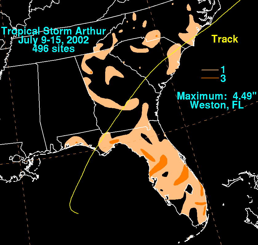 The precursor tropical disturbance dropped light to moderate precipitation in Florida
, Georgia
, and South Carolina
, peaking at 4.49 inches (114 mm) in Weston, Florida
. The system produced scattered precipitation across North Carolina
, generally between 1–3 inches (25–75 mm). On July 16, Arthur passed north of Bermuda
, where it brought gusty winds and 0.57 inches (14.5 mm) of rainfall. As an extratropical storm, Arthur produced gusty winds and dropped about 1 inch (25 mm) of rainfall in Newfoundland. Strong waves capsized a boat in the Conne River, killing one person.
Five ships recorded tropical storm force winds in association with Arthur, of which two were when the storm was extratropical. Early on July 16, a vessel with the call sign Weston reported sustained winds of 51 mph (82 km/h) from the south-southwest, which was the strongest ship reported wind speed. As the storm approached Canada as an extratropical storm, a buoy reported an 8 minute average wind speed of 45 mph (72 km/h), along with a wind gust of 60 mph (97 km/h).
Tropical cyclone
A tropical cyclone is a storm system characterized by a large low-pressure center and numerous thunderstorms that produce strong winds and heavy rain. Tropical cyclones strengthen when water evaporated from the ocean is released as the saturated air rises, resulting in condensation of water vapor...
of the 2002 Atlantic hurricane season
2002 Atlantic hurricane season
The 2002 Atlantic hurricane season was an average Atlantic hurricane season, officially starting on June 1, 2002 and ending on November 30, dates which conventionally limit the period of each year when tropical cyclones in the Atlantic Ocean tend to form...
. The origins of the storm are believed to have been from a decaying cold front
Cold front
A cold front is defined as the leading edge of a cooler mass of air, replacing a warmer mass of air.-Development of cold front:The cooler and denser air wedges under the less-dense warmer air, lifting it...
in the Gulf of Mexico
Gulf of Mexico
The Gulf of Mexico is a partially landlocked ocean basin largely surrounded by the North American continent and the island of Cuba. It is bounded on the northeast, north and northwest by the Gulf Coast of the United States, on the southwest and south by Mexico, and on the southeast by Cuba. In...
, which dropped light to moderate rainfall across the southeastern United States. Developing on July 14 near the coast of North Carolina
North Carolina
North Carolina is a state located in the southeastern United States. The state borders South Carolina and Georgia to the south, Tennessee to the west and Virginia to the north. North Carolina contains 100 counties. Its capital is Raleigh, and its largest city is Charlotte...
, Arthur tracked quickly east-northward through much of its duration as a tropical cyclone. It reached peak winds of 60 mph (95 km/h) on July 16, though as it interacted with a mid-level cyclone and cooler waters it transitioned into an extratropical cyclone
Extratropical cyclone
Extratropical cyclones, sometimes called mid-latitude cyclones or wave cyclones, are a group of cyclones defined as synoptic scale low pressure weather systems that occur in the middle latitudes of the Earth having neither tropical nor polar characteristics, and are connected with fronts and...
. The remnants of Arthur passed over Newfoundland with gusty winds and rainfall, where one person drowned.
Meteorological history
The origins of Tropical Storm Arthur are believed to have been from a decaying cold frontCold front
A cold front is defined as the leading edge of a cooler mass of air, replacing a warmer mass of air.-Development of cold front:The cooler and denser air wedges under the less-dense warmer air, lifting it...
in the northeastern Gulf of Mexico
Gulf of Mexico
The Gulf of Mexico is a partially landlocked ocean basin largely surrounded by the North American continent and the island of Cuba. It is bounded on the northeast, north and northwest by the Gulf Coast of the United States, on the southwest and south by Mexico, and on the southeast by Cuba. In...
in July 2002. By July 9, a weak low-level circulation was first detected, in association with a broad low pressure area
Low pressure area
A low-pressure area, or "low", is a region where the atmospheric pressure at sea level is below that of surrounding locations. Low-pressure systems form under areas of wind divergence which occur in upper levels of the troposphere. The formation process of a low-pressure area is known as...
. Across the region, surface pressures were high, while upper level wind shear
Wind shear
Wind shear, sometimes referred to as windshear or wind gradient, is a difference in wind speed and direction over a relatively short distance in the atmosphere...
was marginally favorable for slow tropical development
Tropical cyclogenesis
Tropical cyclogenesis is the term that describes the development and strengthening of a tropical cyclone in the atmosphere. The mechanisms through which tropical cyclogenesis occurs are distinctly different from those through which mid-latitude cyclogenesis occurs...
. The system tracked slowly north-northwestward, gradually becoming better defined, although thunderstorm activity remained limited and disorganized.
By July 11, dry air and unfavorable wind shear prevented the convection
Convection
Convection is the movement of molecules within fluids and rheids. It cannot take place in solids, since neither bulk current flows nor significant diffusion can take place in solids....
from developing near the center. The low became elongated, though on July 12 the overall convection became more concentrated as it turned to a northeast drift. An approaching mid-level trough
Trough (meteorology)
A trough is an elongated region of relatively low atmospheric pressure, often associated with fronts.Unlike fronts, there is not a universal symbol for a trough on a weather chart. The weather charts in some countries or regions mark troughs by a line. In the United States, a trough may be marked...
caused the system to accelerate northeastward across Florida Panhandle
Florida Panhandle
The Florida Panhandle, an informal, unofficial term for the northwestern part of Florida, is a strip of land roughly 200 miles long and 50 to 100 miles wide , lying between Alabama on the north and the west, Georgia also on the north, and the Gulf of Mexico to the south. Its eastern boundary is...
, though upon doing so the thunderstorm activity quickly diminished. On July 13, forecasters expected the system to be absorbed by the approaching trough. However, the low pressure area emerged into the western Atlantic Ocean
Atlantic Ocean
The Atlantic Ocean is the second-largest of the world's oceanic divisions. With a total area of about , it covers approximately 20% of the Earth's surface and about 26% of its water surface area...
near North Carolina
North Carolina
North Carolina is a state located in the southeastern United States. The state borders South Carolina and Georgia to the south, Tennessee to the west and Virginia to the north. North Carolina contains 100 counties. Its capital is Raleigh, and its largest city is Charlotte...
early on July 14, and upon doing so its convection increased and became better organized. The circulation and convection became further defined, and the National Hurricane Center
National Hurricane Center
The National Hurricane Center , located at Florida International University in Miami, Florida, is the division of the National Weather Service responsible for tracking and predicting weather systems within the tropics between the Prime Meridian and the 140th meridian west poleward to the 30th...
estimates the system developed into Tropical Depression One late on July 14 about 45 miles (75 km) west-southwest of Hatteras, North Carolina
Hatteras, North Carolina
Hatteras is an unincorporated community in Dare County, North Carolina, United States, on the Outer Banks island of Hatteras. North Carolina Highway 12 passes through the community linking it to Frisco and Ocracoke . It is south of the famous Cape Hatteras and the Cape Hatteras Lighthouse in Buxton...
.
Upon becoming a tropical cyclone, the depression was moving quickly to the east-northeast, due to a deepening mid-level low
Surface weather analysis
Surface weather analysis is a special type of weather map that provides a view of weather elements over a geographical area at a specified time based on information from ground-based weather stations...
south of the Canadian Maritimes. It maintained good upper-level outflow
Outflow (meteorology)
Outflow, in meteorology, is air that flows outwards from a storm system. It is associated with ridging, or anticyclonic flow. In the low levels of the troposphere, outflow radiates from thunderstorms in the form of a wedge of rain-cooled air, which is visible as a thin rope-like cloud on weather...
, and its track over the gulf stream
Gulf Stream
The Gulf Stream, together with its northern extension towards Europe, the North Atlantic Drift, is a powerful, warm, and swift Atlantic ocean current that originates at the tip of Florida, and follows the eastern coastlines of the United States and Newfoundland before crossing the Atlantic Ocean...
allowed for steady strengthening. Early on July 15, convection increased over the center and developed an organized rainband southwest of the center; as a result, the National Hurricane Center upgraded the depression to Tropical Storm Arthur. After continuing to steadily intensify, Arthur attained peak winds of 60 mph (95 km/h) early on July 16 about 490 miles (790 km) south-southeast of Halifax, Nova Scotia
Nova Scotia
Nova Scotia is one of Canada's three Maritime provinces and is the most populous province in Atlantic Canada. The name of the province is Latin for "New Scotland," but "Nova Scotia" is the recognized, English-language name of the province. The provincial capital is Halifax. Nova Scotia is the...
. Upon reaching peak intensity, the convection had become well-organized over the center despite westerly wind shear. Subsequently, the center became separated from the area of deepest convection, and Arthur maintained its peak intensity as it began transitioning into an extratropical cyclone
Extratropical cyclone
Extratropical cyclones, sometimes called mid-latitude cyclones or wave cyclones, are a group of cyclones defined as synoptic scale low pressure weather systems that occur in the middle latitudes of the Earth having neither tropical nor polar characteristics, and are connected with fronts and...
. The storm turned northward around the larger mid-level low, and by July 17 Arthur completed extratropical transition. Shortly thereafter, the extratropical remnants crossed eastern Newfoundland. On July 19, the remnants of Arthur turned to a southeast drift between Newfoundland and Greenland
Greenland
Greenland is an autonomous country within the Kingdom of Denmark, located between the Arctic and Atlantic Oceans, east of the Canadian Arctic Archipelago. Though physiographically a part of the continent of North America, Greenland has been politically and culturally associated with Europe for...
, and by late in the day its winds decreased to below gale force.
Impact
Florida
Florida is a state in the southeastern United States, located on the nation's Atlantic and Gulf coasts. It is bordered to the west by the Gulf of Mexico, to the north by Alabama and Georgia and to the east by the Atlantic Ocean. With a population of 18,801,310 as measured by the 2010 census, it...
, Georgia
Georgia (U.S. state)
Georgia is a state located in the southeastern United States. It was established in 1732, the last of the original Thirteen Colonies. The state is named after King George II of Great Britain. Georgia was the fourth state to ratify the United States Constitution, on January 2, 1788...
, and South Carolina
South Carolina
South Carolina is a state in the Deep South of the United States that borders Georgia to the south, North Carolina to the north, and the Atlantic Ocean to the east. Originally part of the Province of Carolina, the Province of South Carolina was one of the 13 colonies that declared independence...
, peaking at 4.49 inches (114 mm) in Weston, Florida
Weston, Florida
Weston is a suburb of South Florida located in Broward County, Florida, USA. Established as a city in 1996, much of the community was developed by Arvida/JMB Realty and is located near the western developmental boundary of Broward County. It is the most western city in Broward County, and its...
. The system produced scattered precipitation across North Carolina
North Carolina
North Carolina is a state located in the southeastern United States. The state borders South Carolina and Georgia to the south, Tennessee to the west and Virginia to the north. North Carolina contains 100 counties. Its capital is Raleigh, and its largest city is Charlotte...
, generally between 1–3 inches (25–75 mm). On July 16, Arthur passed north of Bermuda
Bermuda
Bermuda is a British overseas territory in the North Atlantic Ocean. Located off the east coast of the United States, its nearest landmass is Cape Hatteras, North Carolina, about to the west-northwest. It is about south of Halifax, Nova Scotia, Canada, and northeast of Miami, Florida...
, where it brought gusty winds and 0.57 inches (14.5 mm) of rainfall. As an extratropical storm, Arthur produced gusty winds and dropped about 1 inch (25 mm) of rainfall in Newfoundland. Strong waves capsized a boat in the Conne River, killing one person.
Five ships recorded tropical storm force winds in association with Arthur, of which two were when the storm was extratropical. Early on July 16, a vessel with the call sign Weston reported sustained winds of 51 mph (82 km/h) from the south-southwest, which was the strongest ship reported wind speed. As the storm approached Canada as an extratropical storm, a buoy reported an 8 minute average wind speed of 45 mph (72 km/h), along with a wind gust of 60 mph (97 km/h).
See also
- List of North Carolina hurricanes (1980–present)
- List of Florida hurricanes (2000–present)
- Other tropical cyclones named ArthurTropical Storm ArthurThe name Arthur has been used for five tropical cyclones in the Atlantic Ocean. It is one of three names used for five tropical storms with none of them becoming a hurricane...