
.gif)
Tropical Storm Hanna (2002)
Encyclopedia
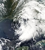
Tropical Storm Hanna was a moderately strong tropical storm that affected the Gulf Coast
and Southeastern regions of the United States. The tenth tropical cyclone
and ninth named storm of the 2002 Atlantic hurricane season
, Hanna formed through the complex interaction of a surface trough
, a tropical wave
, and an upper-level low pressure system
, a disturbance in the upper atmosphere. Designated a tropical depression at 0000 UTC
on September 12, the storm remained disorganized throughout its duration, though it attained tropical storm status and a peak intensity of 1001 mbar (29.6 inHg), with winds of 60 miles per hour (100 km/h). Hanna crossed extreme southeastern Louisiana, and made a second landfall along the Alabama–Mississippi border.
Because most of the associated convective activity was east of the center of circulation
, Louisiana and Mississippi received minimal damage. However, on Dauphin Island, Alabama, the storm caused coastal flooding which closed roads and forced the evacuation of residents. Florida received high wind gusts, heavy rainfall, and strong surf that resulted in the deaths of three swimmers. 20,000 homes in the state lost electricity. The heavy rainfall progressed into Georgia, where significant flooding occurred. Crop damage was extensive, and about 335 structures were damaged by the flooding. The storm caused a total of about $20 million (2002 USD; $23.96 million 2008 USD) in damage.
in early September 2002. At the same time, a westward-moving tropical wave entered the gulf on September 10 and spawned a weak low along the trough, with little associated thunderstorm activity. On September 11, an upper-level low over the United States moved into the Gulf and became cut off from the flow, allowing atmospheric convection
to develop to the east of the tropical wave. The surface low organized, and convection formed closer to the center of the low. At 0000 UTC on September 12, a Hurricane Hunters
aircraft was able to find a well-defined center of circulation; the National Hurricane Center
(NHC) thus designated it a tropical depression while it was about 280 miles (450.6 km) south of Pensacola, Florida
.
 After being designated, the cyclone became disorganized, and contained little deep and persistent convection; with dry air infringing on the western edge of the storm, substantial intensification was deemed unlikely. Despite being sheared
, the cyclone neared tropical storm status later that day, though it remained a depression due to a partially non-tropical appearance. Initially, the depression meandered towards the northeast due to weak steering currents, and it intensified into a tropical storm at 0600 UTC. As such, it was named Hanna by the National Hurricane Center. Over the next 24 hours, the low-level center rotated around the mid- and upper-level centers, and the entire tropical storm turned southwestward by late September 12. After a jog to the northwest, the low-level center became separated from the convection. Meandering, the storm started to turn northward under the steering currents of a southwesterly flow associated with an approaching mid-level trough. Hanna then strengthened sharply to reach to its peak intensity of 60 miles per hour (100 km/h) at 0000 UTC on September 14.
Convection shifted towards the eastern semicircle of the circulation, while the still-exposed center became malformed and elongated. On September 14, the poorly organized cyclone crossed southeastern Louisiana, turned towards the north-northeast and made a second landfall close to the Alabama–Mississippi border at 1500 UTC that day, still at its peak strength. The storm dissipated rapidly as it proceeded inland, and the remnant low pressure area moved into Georgia and South Carolina
.
issued a tropical storm watch for the coastal area between Pascagoula, Mississippi
and the Suwanee River in Florida. A tropical storm warning for the region between Grand Isle, Louisiana
and Apalachicola, Florida
replaced the watch, though it was discontinued east of Apalachicola. All tropical cyclone warnings and watches were discontinued by 1800 UTC on September 14, as there was no longer a need for the advisories. After the landfall, officials issued flood watches for inland parts of Mississippi and Alabama as well as for western portions of Georgia and the Carolinas. On Dauphin Island in Alabama, some residents boarded up windows and filled sandbags provided by local fire departments to prepare for Hanna. The Red Cross opened 10 shelters throughout the Gulf Coast region.
 The total damage caused by Tropical Storm Hanna amounted to about $20 million—equivalent to $23 million in 2008 USD.
Damage was greater in Alabama, where rain reached 7.55 inches (191.8 mm) at Coden
and 5.75 inches (146.1 mm) at Belle Fontaine
. Sustained winds of 40 miles per hour (64.4 km/h) were reported at Dauphin Island, with gusts up to 51 mph (82.1 km/h). The lowest barometric pressure was also at Dauphin Island; it reportedly fell to 1005 mb
. Storm tides of 3.7 feet (1.1 m) caused minor coastal flooding and beach erosion in some areas, including along the causeway
that crosses the Mobile Bay
. One tornado, an F0 on the Fujita Scale
, touched down in south Mobile County
, knocking down trees. Some residents were left without electric power, and there was flooding on both ends of Dauphin Island, leading to road closures. The storm forced the evacuation of some residents on the western end of the island. In addition to the heavy rains, trees were downed in parts of Baldwin County
.
In Florida, peak gusts were recorded at 68 miles per hour (109.4 km/h) near Pensacola Beach
. The winds, combined with associated thunderstorms, caused minor damage, and brought down small trees and power lines. Throughout Walton County
, Hanna left approximately 15,000 customers without power, forming a statewide total of 20,000 power outages. Due to high winds, bridges to offshore islands were closed. Minor beach erosion was reported along the coast of Walton, Bay
and Gulf
counties. Three people drowned in high surf; one near Pensacola Beach, one at Seagrove Beach and another at Panama City Beach
. The fatalities prompted a local Police Major to comment, "People are getting into the water and not paying attention to the warning flags." Heavy rain fell throughout the central and western Panhandle
; the highest reported total was 9.68 inches (245.9 mm), at Chipley
. As a result, rivers topped their banks, while county roads and homes in Perry
, as well as streets in the Tallahassee
region, were flooded. The total damage in Florida is estimated at $400,000 (2002 USD).
, 12.47 inches (316.7 mm) at Carrollton
, and 11.23 in (285.2 mm) at Embry. Although the heaviest rainfall was mostly confined to southwestern parts of the state, precipitation was widespread within a northwest–northeast feeder band over central and northern Georgia. Associated with the band was up to 2 inches (50.8 mm) of rainfall in a matter of hours, as well as gusty thunderstorms. The highest rainfall totals from this individual band were limited to an area north of a line from Atlanta to Athens
. The heavy rainfall helped to relieve a persistent drought, bringing vegetation back to life. However, climatologists determined that the rainfall did not fully alleviate the dry conditions. The band of thunderstorms produced gusts of 40 to 50 mph (64.4 to 80.5 km/h), downing trees and power lines. In the Atlanta metropolitan area, 48,000 customers received power outages. The winds tore a roof off a house and damaged a number of mobile homes. The heavy rainfall caused severe flooding; in Donalsonville, 250 houses and 50 businesses suffered water damage, while another 35 were damaged in nearby Miller County
. Roads were flooded, including parts of U.S. Route 27
. Crop damage was significant in the state. According to the Georgia Farm Services Agency, $19 million (2002 USD; $22 million 2008 USD) in damage to cotton and peanut crops were reported. Due to the flooding and damage, Governor Roy Barnes
declared Seminole, Miller and Decatur counties federal disaster areas.
Moderate to heavy rain extended as far north as the Carolinas, and light showers reached the Delmarva Peninsula
. Locations in western South Carolina picked up around 3 inches (75 mm) of rainfall, causing flooding on some roads and highways. Various streams and ponds topped their banks, and flood waters on some roads reached an estimated 4 to 6 in (101.6 to 152.4 mm) deep. On South Carolina Highway 20, a motorist became stranded in high waters, and nearby houses were damaged. The rainfall delayed a football game at Williams-Brice Stadium
for about 50 minutes. Farther northward, the remnants of Tropical Storm Hanna contributed to around 1 inch (25 mm) of rainfall in New England
, particularly in Vermont
.
Gulf Coast of the United States
The Gulf Coast of the United States, sometimes referred to as the Gulf South, South Coast, or 3rd Coast, comprises the coasts of American states that are on the Gulf of Mexico, which includes Texas, Louisiana, Mississippi, Alabama, and Florida and are known as the Gulf States...
and Southeastern regions of the United States. The tenth tropical cyclone
Tropical cyclone
A tropical cyclone is a storm system characterized by a large low-pressure center and numerous thunderstorms that produce strong winds and heavy rain. Tropical cyclones strengthen when water evaporated from the ocean is released as the saturated air rises, resulting in condensation of water vapor...
and ninth named storm of the 2002 Atlantic hurricane season
2002 Atlantic hurricane season
The 2002 Atlantic hurricane season was an average Atlantic hurricane season, officially starting on June 1, 2002 and ending on November 30, dates which conventionally limit the period of each year when tropical cyclones in the Atlantic Ocean tend to form...
, Hanna formed through the complex interaction of a surface trough
Trough (meteorology)
A trough is an elongated region of relatively low atmospheric pressure, often associated with fronts.Unlike fronts, there is not a universal symbol for a trough on a weather chart. The weather charts in some countries or regions mark troughs by a line. In the United States, a trough may be marked...
, a tropical wave
Tropical wave
Tropical waves, easterly waves, or tropical easterly waves, also known as African easterly waves in the Atlantic region, are a type of atmospheric trough, an elongated area of relatively low air pressure, oriented north to south, which move from east to west across the tropics causing areas of...
, and an upper-level low pressure system
Low pressure area
A low-pressure area, or "low", is a region where the atmospheric pressure at sea level is below that of surrounding locations. Low-pressure systems form under areas of wind divergence which occur in upper levels of the troposphere. The formation process of a low-pressure area is known as...
, a disturbance in the upper atmosphere. Designated a tropical depression at 0000 UTC
Coordinated Universal Time
Coordinated Universal Time is the primary time standard by which the world regulates clocks and time. It is one of several closely related successors to Greenwich Mean Time. Computer servers, online services and other entities that rely on having a universally accepted time use UTC for that purpose...
on September 12, the storm remained disorganized throughout its duration, though it attained tropical storm status and a peak intensity of 1001 mbar (29.6 inHg), with winds of 60 miles per hour (100 km/h). Hanna crossed extreme southeastern Louisiana, and made a second landfall along the Alabama–Mississippi border.
Because most of the associated convective activity was east of the center of circulation
Eye (cyclone)
The eye is a region of mostly calm weather found at the center of strong tropical cyclones. The eye of a storm is a roughly circular area and typically 30–65 km in diameter. It is surrounded by the eyewall, a ring of towering thunderstorms where the second most severe weather of a cyclone...
, Louisiana and Mississippi received minimal damage. However, on Dauphin Island, Alabama, the storm caused coastal flooding which closed roads and forced the evacuation of residents. Florida received high wind gusts, heavy rainfall, and strong surf that resulted in the deaths of three swimmers. 20,000 homes in the state lost electricity. The heavy rainfall progressed into Georgia, where significant flooding occurred. Crop damage was extensive, and about 335 structures were damaged by the flooding. The storm caused a total of about $20 million (2002 USD; $23.96 million 2008 USD) in damage.
Meteorological history
A broad surface trough extended from the western Atlantic Ocean into the Gulf of MexicoGulf of Mexico
The Gulf of Mexico is a partially landlocked ocean basin largely surrounded by the North American continent and the island of Cuba. It is bounded on the northeast, north and northwest by the Gulf Coast of the United States, on the southwest and south by Mexico, and on the southeast by Cuba. In...
in early September 2002. At the same time, a westward-moving tropical wave entered the gulf on September 10 and spawned a weak low along the trough, with little associated thunderstorm activity. On September 11, an upper-level low over the United States moved into the Gulf and became cut off from the flow, allowing atmospheric convection
Atmospheric convection
Atmospheric convection is the result of a parcel-environment instability, or temperature difference, layer in the atmosphere. Different lapse rates within dry and moist air lead to instability. Mixing of air during the day which expands the height of the planetary boundary layer leads to...
to develop to the east of the tropical wave. The surface low organized, and convection formed closer to the center of the low. At 0000 UTC on September 12, a Hurricane Hunters
Hurricane Hunters
The Hurricane Hunters are aircraft that fly into tropical cyclones in the North Atlantic Ocean and Northeastern Pacific Ocean for the specific purpose of directly measuring weather data in and around those storms. In the United States, the Air Force, Navy, and NOAA units have all participated in...
aircraft was able to find a well-defined center of circulation; the National Hurricane Center
National Hurricane Center
The National Hurricane Center , located at Florida International University in Miami, Florida, is the division of the National Weather Service responsible for tracking and predicting weather systems within the tropics between the Prime Meridian and the 140th meridian west poleward to the 30th...
(NHC) thus designated it a tropical depression while it was about 280 miles (450.6 km) south of Pensacola, Florida
Pensacola, Florida
Pensacola is the westernmost city in the Florida Panhandle and the county seat of Escambia County, Florida, United States of America. As of the 2000 census, the city had a total population of 56,255 and as of 2009, the estimated population was 53,752...
.
Wind shear
Wind shear, sometimes referred to as windshear or wind gradient, is a difference in wind speed and direction over a relatively short distance in the atmosphere...
, the cyclone neared tropical storm status later that day, though it remained a depression due to a partially non-tropical appearance. Initially, the depression meandered towards the northeast due to weak steering currents, and it intensified into a tropical storm at 0600 UTC. As such, it was named Hanna by the National Hurricane Center. Over the next 24 hours, the low-level center rotated around the mid- and upper-level centers, and the entire tropical storm turned southwestward by late September 12. After a jog to the northwest, the low-level center became separated from the convection. Meandering, the storm started to turn northward under the steering currents of a southwesterly flow associated with an approaching mid-level trough. Hanna then strengthened sharply to reach to its peak intensity of 60 miles per hour (100 km/h) at 0000 UTC on September 14.
Convection shifted towards the eastern semicircle of the circulation, while the still-exposed center became malformed and elongated. On September 14, the poorly organized cyclone crossed southeastern Louisiana, turned towards the north-northeast and made a second landfall close to the Alabama–Mississippi border at 1500 UTC that day, still at its peak strength. The storm dissipated rapidly as it proceeded inland, and the remnant low pressure area moved into Georgia and South Carolina
South Carolina
South Carolina is a state in the Deep South of the United States that borders Georgia to the south, North Carolina to the north, and the Atlantic Ocean to the east. Originally part of the Province of Carolina, the Province of South Carolina was one of the 13 colonies that declared independence...
.
Preparations
Shortly after the formation of the storm, the National Hurricane CenterNational Hurricane Center
The National Hurricane Center , located at Florida International University in Miami, Florida, is the division of the National Weather Service responsible for tracking and predicting weather systems within the tropics between the Prime Meridian and the 140th meridian west poleward to the 30th...
issued a tropical storm watch for the coastal area between Pascagoula, Mississippi
Pascagoula, Mississippi
Pascagoula is a city in Jackson County, Mississippi, United States. It is the principal city of the Pascagoula, Mississippi Metropolitan Statistical Area, as a part of the Gulfport–Biloxi–Pascagoula, Mississippi Combined Statistical Area. The population was 26,200 at the 2000 census...
and the Suwanee River in Florida. A tropical storm warning for the region between Grand Isle, Louisiana
Grand Isle, Louisiana
Grand Isle is a town in Jefferson Parish, Louisiana, located on a barrier island of the same name in the Gulf of Mexico. The island is at the mouth of Barataria Bay where it meets the gulf. As of the 2000 census, the town population was 1,541; during summers, the population sometimes increases to...
and Apalachicola, Florida
Apalachicola, Florida
Apalachicola is a city in Franklin County, Florida, on US 98 about southwest of Tallahassee. The population was 2,334 at the 2000 census. The 2005 census estimated the city's population at 2,340...
replaced the watch, though it was discontinued east of Apalachicola. All tropical cyclone warnings and watches were discontinued by 1800 UTC on September 14, as there was no longer a need for the advisories. After the landfall, officials issued flood watches for inland parts of Mississippi and Alabama as well as for western portions of Georgia and the Carolinas. On Dauphin Island in Alabama, some residents boarded up windows and filled sandbags provided by local fire departments to prepare for Hanna. The Red Cross opened 10 shelters throughout the Gulf Coast region.
Impact
U.S. Gulf Coast
In Louisiana, damage was light, as the majority of Hanna's convective activity was to the east. Rainfall was mostly less than 1 inches (25 mm), and little rise in tide was reported. Little or no damage occurred in neighboring Mississippi, where similar effects were reported.Damage was greater in Alabama, where rain reached 7.55 inches (191.8 mm) at Coden
Coden, Alabama
Coden is an unincorporated coastal fishing village in southern Mobile County, Alabama. Located near Bayou la Batre, it is across the Mississippi Sound from Dauphin Island.-History:...
and 5.75 inches (146.1 mm) at Belle Fontaine
Belle Fontaine, Alabama
Belle Fontaine is an unincorporated community and census-designated place in Mobile County, Alabama, on the western shore of Mobile Bay. It is located south of the city of Mobile, along the stretch of shore between Deer River and Fowl River...
. Sustained winds of 40 miles per hour (64.4 km/h) were reported at Dauphin Island, with gusts up to 51 mph (82.1 km/h). The lowest barometric pressure was also at Dauphin Island; it reportedly fell to 1005 mb
Bar (unit)
The bar is a unit of pressure equal to 100 kilopascals, and roughly equal to the atmospheric pressure on Earth at sea level. Other units derived from the bar are the megabar , kilobar , decibar , centibar , and millibar...
. Storm tides of 3.7 feet (1.1 m) caused minor coastal flooding and beach erosion in some areas, including along the causeway
Causeway
In modern usage, a causeway is a road or railway elevated, usually across a broad body of water or wetland.- Etymology :When first used, the word appeared in a form such as “causey way” making clear its derivation from the earlier form “causey”. This word seems to have come from the same source by...
that crosses the Mobile Bay
Mobile Bay
Mobile Bay is an inlet of the Gulf of Mexico, lying within the state of Alabama in the United States. Its mouth is formed by the Fort Morgan Peninsula on the eastern side and Dauphin Island, a barrier island on the western side. The Mobile River and Tensaw River empty into the northern end of the...
. One tornado, an F0 on the Fujita Scale
Fujita scale
The Fujita scale , or Fujita-Pearson scale, is a scale for rating tornado intensity, based primarily on the damage tornadoes inflict on human-built structures and vegetation...
, touched down in south Mobile County
Mobile County, Alabama
Mobile County[p] is a county of the U.S. state of Alabama. Its name is in honor of a tribe of Indians, the Maubila tribe . As of 2011, its population was 415,704. Its county seat is Mobile, Alabama...
, knocking down trees. Some residents were left without electric power, and there was flooding on both ends of Dauphin Island, leading to road closures. The storm forced the evacuation of some residents on the western end of the island. In addition to the heavy rains, trees were downed in parts of Baldwin County
Baldwin County, Alabama
-2010:Whereas according to the 2010 U.S. Census Bureau:*85.7% White*9.4% Black*0.7% Native American*0.7% Asian*0.0% Native Hawaiian or Pacific Islander*1.5% Two or more races*4.4% Hispanic or Latino -2000:...
.
In Florida, peak gusts were recorded at 68 miles per hour (109.4 km/h) near Pensacola Beach
Pensacola Beach, Florida
Pensacola Beach is an unincorporated community located on Santa Rosa Island, a barrier island, in Escambia County, Florida, United States. It is situated south of Pensacola, and Gulf Breeze connected via bridges spanning to the Fairpoint Peninsula and then to the island, on the Gulf of Mexico...
. The winds, combined with associated thunderstorms, caused minor damage, and brought down small trees and power lines. Throughout Walton County
Walton County, Florida
Walton County is a county located in the state of Florida. As of 2000, the population was 40,601. The U.S. Census Bureau 2005 estimate for the county is 50,324. Its county seat is DeFuniak Springs, Florida. The county is home to the highest natural point in Florida: Britton Hill, at .- History...
, Hanna left approximately 15,000 customers without power, forming a statewide total of 20,000 power outages. Due to high winds, bridges to offshore islands were closed. Minor beach erosion was reported along the coast of Walton, Bay
Bay County, Florida
Bay County is a county located in the U.S. state of Florida. The U.S. Census Bureau 2006 estimate for the county is 163,505 . Its county seat is Panama City, Florida. The county is best known for its white sand beaches and crystal blue water, where large pods of dolphins swim year-round...
and Gulf
Gulf County, Florida
Gulf County is a county located in the panhandle of the U.S. state of Florida. As of 2000, the population was 13,332. The U.S. Census Bureau 2005 estimate for the county is 13,975 . Its county seat is Port St. Joe.- History :...
counties. Three people drowned in high surf; one near Pensacola Beach, one at Seagrove Beach and another at Panama City Beach
Panama City Beach, Florida
Panama City Beach is a city in Bay County, Florida, United States, on the Gulf of Mexico coast. The city is often referred to under the umbrella term of "Panama City", despite being a distinct municipality from the older and larger inland Panama City to the east, making Panama City and Panama City...
. The fatalities prompted a local Police Major to comment, "People are getting into the water and not paying attention to the warning flags." Heavy rain fell throughout the central and western Panhandle
Florida Panhandle
The Florida Panhandle, an informal, unofficial term for the northwestern part of Florida, is a strip of land roughly 200 miles long and 50 to 100 miles wide , lying between Alabama on the north and the west, Georgia also on the north, and the Gulf of Mexico to the south. Its eastern boundary is...
; the highest reported total was 9.68 inches (245.9 mm), at Chipley
Chipley, Florida
Chipley is a city in Washington County, Florida, United States. Its population was 3,592 at the time of the 2000 U.S. Census. According to the United States Census Bureau estimates of 2005, the city had a population of about 3,682...
. As a result, rivers topped their banks, while county roads and homes in Perry
Perry, Florida
Perry is a city in Taylor County, Florida, United States. The population was 7,017 at the 2010 census. As of 2010, the population recorded by the U.S. Census Bureau is 7,017....
, as well as streets in the Tallahassee
Tallahassee, Florida
Tallahassee is the capital of the U.S. state of Florida. It is the county seat and only incorporated municipality in Leon County, and is the 128th largest city in the United States. Tallahassee became the capital of Florida, then the Florida Territory, in 1824. In 2010, the population recorded by...
region, were flooded. The total damage in Florida is estimated at $400,000 (2002 USD).
Eastern United States
Hanna dropped heavy rainfall across much of Georgia, peaking at 15.56 inches (395.2 mm) at DonalsonvilleDonalsonville, Georgia
Donalsonville is a city in Seminole County, Georgia, United States. The population was 2,796 at the 2000 census. The city is the county seat of Seminole County.-History:...
, 12.47 inches (316.7 mm) at Carrollton
Carrollton, Georgia
Carrollton is a city in West Georgia, United States, in the foothills of the Appalachian Mountains. As of the 2010 census, the city had a population of 24,388...
, and 11.23 in (285.2 mm) at Embry. Although the heaviest rainfall was mostly confined to southwestern parts of the state, precipitation was widespread within a northwest–northeast feeder band over central and northern Georgia. Associated with the band was up to 2 inches (50.8 mm) of rainfall in a matter of hours, as well as gusty thunderstorms. The highest rainfall totals from this individual band were limited to an area north of a line from Atlanta to Athens
Athens, Georgia
Athens-Clarke County is a consolidated city–county in U.S. state of Georgia, in the northeastern part of the state, comprising the former City of Athens proper and Clarke County. The University of Georgia is located in this college town and is responsible for the initial growth of the city...
. The heavy rainfall helped to relieve a persistent drought, bringing vegetation back to life. However, climatologists determined that the rainfall did not fully alleviate the dry conditions. The band of thunderstorms produced gusts of 40 to 50 mph (64.4 to 80.5 km/h), downing trees and power lines. In the Atlanta metropolitan area, 48,000 customers received power outages. The winds tore a roof off a house and damaged a number of mobile homes. The heavy rainfall caused severe flooding; in Donalsonville, 250 houses and 50 businesses suffered water damage, while another 35 were damaged in nearby Miller County
Miller County, Georgia
Miller County is a county located in the U.S. state of Georgia. It was created on February 26, 1856. As of 2000, the population was 6,383. The 2007 Census Estimate shows a population of 6,163. The county seat is Colquitt.-Geography:...
. Roads were flooded, including parts of U.S. Route 27
U.S. Route 27
U.S. Route 27 is a north–south United States highway in the southern and midwestern United States. The southern terminus is at US 1 in Miami, Florida. The northern terminus is at Interstate 69 in Fort Wayne, Indiana...
. Crop damage was significant in the state. According to the Georgia Farm Services Agency, $19 million (2002 USD; $22 million 2008 USD) in damage to cotton and peanut crops were reported. Due to the flooding and damage, Governor Roy Barnes
Roy Barnes
Roy Eugene Barnes served as the 80th Governor of Georgia from January 1999 until January 2003. Barnes was also a candidate for Governor of Georgia in the 2010 election....
declared Seminole, Miller and Decatur counties federal disaster areas.
Moderate to heavy rain extended as far north as the Carolinas, and light showers reached the Delmarva Peninsula
Delmarva Peninsula
The Delmarva Peninsula is a large peninsula on the East Coast of the United States, occupied by most of Delaware and portions of Maryland and Virginia...
. Locations in western South Carolina picked up around 3 inches (75 mm) of rainfall, causing flooding on some roads and highways. Various streams and ponds topped their banks, and flood waters on some roads reached an estimated 4 to 6 in (101.6 to 152.4 mm) deep. On South Carolina Highway 20, a motorist became stranded in high waters, and nearby houses were damaged. The rainfall delayed a football game at Williams-Brice Stadium
Williams-Brice Stadium
Williams-Brice Stadium is the home football stadium for the South Carolina Gamecocks, the college football team representing the University of South Carolina in Columbia, South Carolina...
for about 50 minutes. Farther northward, the remnants of Tropical Storm Hanna contributed to around 1 inch (25 mm) of rainfall in New England
New England
New England is a region in the northeastern corner of the United States consisting of the six states of Maine, New Hampshire, Vermont, Massachusetts, Rhode Island, and Connecticut...
, particularly in Vermont
Vermont
Vermont is a state in the New England region of the northeastern United States of America. The state ranks 43rd in land area, , and 45th in total area. Its population according to the 2010 census, 630,337, is the second smallest in the country, larger only than Wyoming. It is the only New England...
.
See also
- Tropical cycloneTropical cycloneA tropical cyclone is a storm system characterized by a large low-pressure center and numerous thunderstorms that produce strong winds and heavy rain. Tropical cyclones strengthen when water evaporated from the ocean is released as the saturated air rises, resulting in condensation of water vapor...
- List of Florida hurricanes
- List of North Carolina hurricanes
- List of Delaware hurricanes