
.gif)
Hurricane Ophelia (2005)
Encyclopedia
Hurricane Ophelia was the fifteenth named tropical cyclone
and the eighth hurricane of the 2005 Atlantic hurricane season
. It was a long-lived storm that was most remembered for its very erratic and extremely slow track off the East Coast of the United States
, alternating several times between tropical storm and hurricane intensity.
Ophelia caused some damage and beach erosion along the United States coastline from Florida
to North Carolina
, with its closest approach occurring on September 14 and 15 with its western eyewall crossing land and the eye remaining just offshore. Minimal damage and erosion was also reported in Atlantic Canada
when Ophelia hit as a tropical storm in extratropical
transition on September 17 and 18.
and Grand Bahama
. Shortly after forming the depression moved over Grand Bahama and moved north parallel to the Florida
coastline. The computer models initially predicted two distinct possibilities for the storm's future with some models indicating the storm would cross over Florida and enter the Gulf of Mexico
while others indicated that it would stay offshore and move to the northeast. The official forecast from the National Hurricane Center
followed the first set of guidance, though with low confidence. The storm strengthened to become Tropical Storm Ophelia early on September 7 and became a hurricane briefly the next day.
From September 9 to September 11, Ophelia fluctuated in strength, being downgraded to a tropical storm only to regain hurricane intensity three more times; during this time it moved very slowly and erratically in a northeasterly direction. The NHC continued to struggle to predict Ophelia, with the forecasts generally calling for a landfall on the east coast of the United States. The forecasters indicated there was a possibility that Ophelia could strengthen further to Category 3
strength, though they felt this was unlikely. On September 12 the storm completed a clockwise loop, then adopted a more north-westerly motion towards North Carolina
, while still moving only slowly and fitfully. It dropped below hurricane strength again when the inner core of convection collapsed, possibly due to passing over cooler water that it upwelled earlier in its track. Ophelia then regained hurricane strength over the warm waters of the Gulf Stream. After the collapse of the inner core of convection, the hurricane acquired an unusually large eye over 115 miles (185 km) across and soon reached its peak strength with 85 mph (140 km/h) winds. The northern and western eyewall passed over the coastal areas of North Carolina throughout September 14–15, but the strongest winds remained offshore.
As Hurricane Ophelia moved past Cape Hatteras
it turned to the east. Wind shear increased on September 16 and weakened Ophelia into a tropical storm for the last time. Ophelia turned to the northeast and brushed past Nantucket Island, Massachusetts
the next day. As it approached Nova Scotia
on September 17, the storm became extratropical but maintained its strength as it made landfall in the extreme eastern portion of the province. The extratropical storm passed over southern Newfoundland later that day and finally dissipated on September 23 in the North Sea
.
for the northwestern Bahamas and the National Hurricane Center
issued a tropical storm warning for much of the east Florida
coastline. On September 10, with forecasts indicating that Ophelia would make landfall in South Carolina
as a hurricane, the NHC issued a hurricane watch for much of the coastline of the Carolinas
. As the storm neared the Outer Banks
, the watch was upgraded to a warning for the areas closest to the predicted route of the storm. On Ocracoke Island, roughly 3,000 tourists and 800 local residents were evacuated to inland shelters after a mandatory evacuation order was issued for the island.
As Ophelia was predicted to pass near southeast New England
, the NHC issued tropical storm warnings for much of the south Massachusetts
and Rhode Island
coastlines. In Atlantic Canada
, considerable preparations were taken for Ophelia, primarily because of memories of Hurricane Juan
of the 2003 season
, which had caught the authorities off-guard. Ophelia prompted the Canadian Hurricane Centre
's first ever tropical storm warnings which were canceled when Ophelia became extratropical.
, and South Carolina
. Average swells
of 6 to 8 ft (1.8 to 2.4 m) affected the region for several days as the storm meandered offshore. Squall line
s associated with the storm brought moderate to heavy rains along with high winds, gusting to 62 mph (99.8 km/h) in isolated thunderstorms. Along the northeastern coast of Florida, up to 5.04 in (128 mm) of rain fell; some areas recorded 3.5 in (88.9 mm) in a six-hour span on September 6. Between September 6 and 9, torrential rainfall, measured up to 15.2 in (386.1 mm) in Flagler County
, led to moderate street flooding, especially along poorly drained secondary roads. At Flagler Beach, Florida
, the erosion endangered the foundation of highway A1A, and 140 dump trucks were brought in to buttress the road with rocks and sand. In Palm Beach County
, one man drowned after being caught in rough seas associated with Ophelia.
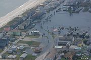
 Ophelia moved extremely slowly in and around North Carolina, causing the storm to drop more than 10 inches (254 mm) of rain on many coastal areas. The highest amount measured was from Oak Island, where 17.5 inches (445 mm) was registered. In addition, storm surges of 7–12 feet (2–4 m) were recorded, particularly in low-lying inlets of Pamlico Sound
. At the storm's peak, over 240,000 customers were without power in coastal North Carolina. One indirect fatality was reported due to a traffic accident related to Ophelia, although no direct deaths were recorded.
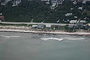
 Damage was heaviest in Salter Path, North Carolina
and along the Outer Banks
near that community, where (despite being only a Category 1
storm) many buildings suffered significant damage as a result of the storm surge, which has been described as worse than Hurricane Isabel
in 2003 and even compared to Hurricane Hazel
in 1954. Nearly all of the significant damage occurred on the sound side, or the side facing the mainland. In addition, several piers and many boats were damaged or destroyed by Ophelia's storm surge. Damage was generally lighter on the mainland, and overall structural damage was relatively light, although there was considerable flooding reported in the Wilmington
area. Damage was initially estimated to be about $1.6 billion, but in final analysis was dropped to only $70 million (2005 USD; $77.3 million 2008 USD). On October 7, President George W. Bush
declared a state of emergency
for ten counties in North Carolina as a result of Ophelia.
and Canada, overall damage was minimal, and only brief, sporadic power outages were reported. One indirect storm-related fatality was reported in Nova Scotia
as a result of a person falling during minor roof repairs. In Newfoundland, over 1.96 inches (50 millimeters) of rain fell over parts of the eastern region of the province.
NHC's Tropical Cyclone Report on Hurricane Ophelia.
NHC's archive on Hurricane Ophelia.
HPC's rainfall page on Hurricane Ophelia.
Canadian Hurricane Centre
's public advisories on Hurricane Ophelia.
Tropical cyclone
A tropical cyclone is a storm system characterized by a large low-pressure center and numerous thunderstorms that produce strong winds and heavy rain. Tropical cyclones strengthen when water evaporated from the ocean is released as the saturated air rises, resulting in condensation of water vapor...
and the eighth hurricane of the 2005 Atlantic hurricane season
2005 Atlantic hurricane season
The 2005 Atlantic hurricane season was the most active Atlantic hurricane season in recorded history, repeatedly shattering numerous records. The impact of the season was widespread and ruinous with an estimated 3,913 deaths and record damage of about $159.2 billion...
. It was a long-lived storm that was most remembered for its very erratic and extremely slow track off the East Coast of the United States
East Coast of the United States
The East Coast of the United States, also known as the Eastern Seaboard, refers to the easternmost coastal states in the United States, which touch the Atlantic Ocean and stretch up to Canada. The term includes the U.S...
, alternating several times between tropical storm and hurricane intensity.
Ophelia caused some damage and beach erosion along the United States coastline from Florida
Florida
Florida is a state in the southeastern United States, located on the nation's Atlantic and Gulf coasts. It is bordered to the west by the Gulf of Mexico, to the north by Alabama and Georgia and to the east by the Atlantic Ocean. With a population of 18,801,310 as measured by the 2010 census, it...
to North Carolina
North Carolina
North Carolina is a state located in the southeastern United States. The state borders South Carolina and Georgia to the south, Tennessee to the west and Virginia to the north. North Carolina contains 100 counties. Its capital is Raleigh, and its largest city is Charlotte...
, with its closest approach occurring on September 14 and 15 with its western eyewall crossing land and the eye remaining just offshore. Minimal damage and erosion was also reported in Atlantic Canada
Atlantic Canada
Atlantic Canada is the region of Canada comprising the four provinces located on the Atlantic coast, excluding Quebec: the three Maritime provinces – New Brunswick, Prince Edward Island, and Nova Scotia – and Newfoundland and Labrador...
when Ophelia hit as a tropical storm in extratropical
Extratropical cyclone
Extratropical cyclones, sometimes called mid-latitude cyclones or wave cyclones, are a group of cyclones defined as synoptic scale low pressure weather systems that occur in the middle latitudes of the Earth having neither tropical nor polar characteristics, and are connected with fronts and...
transition on September 17 and 18.
Meteorological history
On September 6 a non-tropical low over the northern Bahamas became more organized and formed into Tropical Depression Sixteen between AndrosAndros, Bahamas
Andros Island is an archipelago within the archipelago-nation of the Bahamas, the largest of the 26 inhabited Bahamian Islands. Geo-politically considered a single island, Andros has an area greater than all the other 700 Bahamian islands combined...
and Grand Bahama
Grand Bahama
Grand Bahama is one of the northernmost of the islands of the Bahamas, and the closest major island to the United States, lying off the state of Florida. Grand Bahama is the fifth largest island in the Bahamas island chain of approximately 700 islands and 2,400 cays...
. Shortly after forming the depression moved over Grand Bahama and moved north parallel to the Florida
Florida
Florida is a state in the southeastern United States, located on the nation's Atlantic and Gulf coasts. It is bordered to the west by the Gulf of Mexico, to the north by Alabama and Georgia and to the east by the Atlantic Ocean. With a population of 18,801,310 as measured by the 2010 census, it...
coastline. The computer models initially predicted two distinct possibilities for the storm's future with some models indicating the storm would cross over Florida and enter the Gulf of Mexico
Gulf of Mexico
The Gulf of Mexico is a partially landlocked ocean basin largely surrounded by the North American continent and the island of Cuba. It is bounded on the northeast, north and northwest by the Gulf Coast of the United States, on the southwest and south by Mexico, and on the southeast by Cuba. In...
while others indicated that it would stay offshore and move to the northeast. The official forecast from the National Hurricane Center
National Hurricane Center
The National Hurricane Center , located at Florida International University in Miami, Florida, is the division of the National Weather Service responsible for tracking and predicting weather systems within the tropics between the Prime Meridian and the 140th meridian west poleward to the 30th...
followed the first set of guidance, though with low confidence. The storm strengthened to become Tropical Storm Ophelia early on September 7 and became a hurricane briefly the next day.
From September 9 to September 11, Ophelia fluctuated in strength, being downgraded to a tropical storm only to regain hurricane intensity three more times; during this time it moved very slowly and erratically in a northeasterly direction. The NHC continued to struggle to predict Ophelia, with the forecasts generally calling for a landfall on the east coast of the United States. The forecasters indicated there was a possibility that Ophelia could strengthen further to Category 3
Saffir-Simpson Hurricane Scale
The Saffir–Simpson Hurricane Scale , or the Saffir–Simpson Hurricane Wind Scale , classifies hurricanes — Western Hemisphere tropical cyclones that exceed the intensities of tropical depressions and tropical storms — into five categories distinguished by the intensities of their sustained winds...
strength, though they felt this was unlikely. On September 12 the storm completed a clockwise loop, then adopted a more north-westerly motion towards North Carolina
North Carolina
North Carolina is a state located in the southeastern United States. The state borders South Carolina and Georgia to the south, Tennessee to the west and Virginia to the north. North Carolina contains 100 counties. Its capital is Raleigh, and its largest city is Charlotte...
, while still moving only slowly and fitfully. It dropped below hurricane strength again when the inner core of convection collapsed, possibly due to passing over cooler water that it upwelled earlier in its track. Ophelia then regained hurricane strength over the warm waters of the Gulf Stream. After the collapse of the inner core of convection, the hurricane acquired an unusually large eye over 115 miles (185 km) across and soon reached its peak strength with 85 mph (140 km/h) winds. The northern and western eyewall passed over the coastal areas of North Carolina throughout September 14–15, but the strongest winds remained offshore.
As Hurricane Ophelia moved past Cape Hatteras
Cape Hatteras
Cape Hatteras is a cape on the coast of North Carolina. It is the point that protrudes the farthest to the southeast along the northeast-to-southwest line of the Atlantic coast of North America...
it turned to the east. Wind shear increased on September 16 and weakened Ophelia into a tropical storm for the last time. Ophelia turned to the northeast and brushed past Nantucket Island, Massachusetts
Massachusetts
The Commonwealth of Massachusetts is a state in the New England region of the northeastern United States of America. It is bordered by Rhode Island and Connecticut to the south, New York to the west, and Vermont and New Hampshire to the north; at its east lies the Atlantic Ocean. As of the 2010...
the next day. As it approached Nova Scotia
Nova Scotia
Nova Scotia is one of Canada's three Maritime provinces and is the most populous province in Atlantic Canada. The name of the province is Latin for "New Scotland," but "Nova Scotia" is the recognized, English-language name of the province. The provincial capital is Halifax. Nova Scotia is the...
on September 17, the storm became extratropical but maintained its strength as it made landfall in the extreme eastern portion of the province. The extratropical storm passed over southern Newfoundland later that day and finally dissipated on September 23 in the North Sea
North Sea
In the southwest, beyond the Straits of Dover, the North Sea becomes the English Channel connecting to the Atlantic Ocean. In the east, it connects to the Baltic Sea via the Skagerrak and Kattegat, narrow straits that separate Denmark from Norway and Sweden respectively...
.
Preparations
As soon as Tropical Depression Sixteen formed on September 6, the government of the Bahamas issued a tropical storm warningTropical cyclone warnings and watches
Warnings and watches are two levels of alert issued by national weather forecasting bodies to coastal areas threatened by the imminent approach of a tropical cyclone of tropical storm or hurricane intensity. They are notices to the local population and civil authorities to make appropriate...
for the northwestern Bahamas and the National Hurricane Center
National Hurricane Center
The National Hurricane Center , located at Florida International University in Miami, Florida, is the division of the National Weather Service responsible for tracking and predicting weather systems within the tropics between the Prime Meridian and the 140th meridian west poleward to the 30th...
issued a tropical storm warning for much of the east Florida
Florida
Florida is a state in the southeastern United States, located on the nation's Atlantic and Gulf coasts. It is bordered to the west by the Gulf of Mexico, to the north by Alabama and Georgia and to the east by the Atlantic Ocean. With a population of 18,801,310 as measured by the 2010 census, it...
coastline. On September 10, with forecasts indicating that Ophelia would make landfall in South Carolina
South Carolina
South Carolina is a state in the Deep South of the United States that borders Georgia to the south, North Carolina to the north, and the Atlantic Ocean to the east. Originally part of the Province of Carolina, the Province of South Carolina was one of the 13 colonies that declared independence...
as a hurricane, the NHC issued a hurricane watch for much of the coastline of the Carolinas
The Carolinas
The Carolinas is a term used in the United States to refer collectively to the states of North and South Carolina. Together, the two states + have a population of 13,942,126. "Carolina" would be the fifth most populous state behind California, Texas, New York, and Florida...
. As the storm neared the Outer Banks
Outer Banks
The Outer Banks is a 200-mile long string of narrow barrier islands off the coast of North Carolina, beginning in the southeastern corner of Virginia Beach on the east coast of the United States....
, the watch was upgraded to a warning for the areas closest to the predicted route of the storm. On Ocracoke Island, roughly 3,000 tourists and 800 local residents were evacuated to inland shelters after a mandatory evacuation order was issued for the island.
As Ophelia was predicted to pass near southeast New England
New England
New England is a region in the northeastern corner of the United States consisting of the six states of Maine, New Hampshire, Vermont, Massachusetts, Rhode Island, and Connecticut...
, the NHC issued tropical storm warnings for much of the south Massachusetts
Massachusetts
The Commonwealth of Massachusetts is a state in the New England region of the northeastern United States of America. It is bordered by Rhode Island and Connecticut to the south, New York to the west, and Vermont and New Hampshire to the north; at its east lies the Atlantic Ocean. As of the 2010...
and Rhode Island
Rhode Island
The state of Rhode Island and Providence Plantations, more commonly referred to as Rhode Island , is a state in the New England region of the United States. It is the smallest U.S. state by area...
coastlines. In Atlantic Canada
Atlantic Canada
Atlantic Canada is the region of Canada comprising the four provinces located on the Atlantic coast, excluding Quebec: the three Maritime provinces – New Brunswick, Prince Edward Island, and Nova Scotia – and Newfoundland and Labrador...
, considerable preparations were taken for Ophelia, primarily because of memories of Hurricane Juan
Hurricane Juan
Hurricane Juan was a significant hurricane that struck the southern part of Atlantic Canada in late September 2003. It was the tenth named storm and the sixth hurricane of the 2003 Atlantic hurricane season. Juan formed southeast of Bermuda on September 24, 2003 out of a tropical wave that tracked...
of the 2003 season
2003 Atlantic hurricane season
The 2003 Atlantic hurricane season was an active Atlantic hurricane season with tropical activity before and after the official bounds of the season – the first such occurrence in 50 years. The season produced 21 tropical cyclones, of which 16 developed into named storms; seven...
, which had caught the authorities off-guard. Ophelia prompted the Canadian Hurricane Centre
Canadian Hurricane Centre
The Canadian Hurricane Centre is a division of the Meteorological Service of Canada, an agency of Canada's Department of the Environment, which exists to advise Canadians on the threat of tropical cyclones such as hurricanes and tropical storms...
's first ever tropical storm warnings which were canceled when Ophelia became extratropical.
Southeastern United States
Before Ophelia made its closest approach to land near the Outer Banks on September 15 and 16, it caused moderate beach erosion along the Florida, GeorgiaGeorgia (U.S. state)
Georgia is a state located in the southeastern United States. It was established in 1732, the last of the original Thirteen Colonies. The state is named after King George II of Great Britain. Georgia was the fourth state to ratify the United States Constitution, on January 2, 1788...
, and South Carolina
South Carolina
South Carolina is a state in the Deep South of the United States that borders Georgia to the south, North Carolina to the north, and the Atlantic Ocean to the east. Originally part of the Province of Carolina, the Province of South Carolina was one of the 13 colonies that declared independence...
. Average swells
Swell (ocean)
A swell, in the context of an ocean, sea or lake, is a series surface gravity waves that is not generated by the local wind. Swell waves often have a long wavelength but this varies with the size of the water body, e.g. rarely more than 150 m in the Mediterranean, and from event to event, with...
of 6 to 8 ft (1.8 to 2.4 m) affected the region for several days as the storm meandered offshore. Squall line
Squall line
A squall line is a line of severe thunderstorms that can form along or ahead of a cold front. In the early 20th century, the term was used as a synonym for cold front. It contains heavy precipitation, hail, frequent lightning, strong straight-line winds, and possibly tornadoes and waterspouts....
s associated with the storm brought moderate to heavy rains along with high winds, gusting to 62 mph (99.8 km/h) in isolated thunderstorms. Along the northeastern coast of Florida, up to 5.04 in (128 mm) of rain fell; some areas recorded 3.5 in (88.9 mm) in a six-hour span on September 6. Between September 6 and 9, torrential rainfall, measured up to 15.2 in (386.1 mm) in Flagler County
Flagler County, Florida
Flagler County was created in 1917 from portions of Saint Johns and Volusia counties. It was named for Henry Morrison Flagler, a famous railroad builder who built the Florida East Coast Railway. Bunnell is the county seat of Flagler County....
, led to moderate street flooding, especially along poorly drained secondary roads. At Flagler Beach, Florida
Flagler Beach, Florida
Flagler Beach is a city in Flagler and Volusia counties in the U.S. state of Florida. The population was 4,954 at the 2000 census, with an estimated population of 5,228 in 2004.Flagler Beach is part of the Palm Coast Metropolitan Statistical Area...
, the erosion endangered the foundation of highway A1A, and 140 dump trucks were brought in to buttress the road with rocks and sand. In Palm Beach County
Palm Beach County, Florida
Palm Beach County is the largest county in the state of Florida in total area, and third in population. As of 2010, the county's estimated population was 1,320,134, making it the twenty-eighth most populous in the United States...
, one man drowned after being caught in rough seas associated with Ophelia.
North Carolina
Pamlico Sound
Pamlico Sound in North Carolina, is the largest lagoon along the U.S. East Coast, being long and 24 to 48 km wide. It is a body of water separated from the Atlantic Ocean by the Outer Banks, a row of low, sandy barrier islands, including Cape Hatteras. The Neuse and Pamlico rivers flow in...
. At the storm's peak, over 240,000 customers were without power in coastal North Carolina. One indirect fatality was reported due to a traffic accident related to Ophelia, although no direct deaths were recorded.
Salter Path, North Carolina
Salter Path is an unincorporated community in Carteret County, North Carolina, United States. A Crystal Coast community, it lies on Bogue Banks between the towns of Emerald Isle and Indian Beach.-History:...
and along the Outer Banks
Outer Banks
The Outer Banks is a 200-mile long string of narrow barrier islands off the coast of North Carolina, beginning in the southeastern corner of Virginia Beach on the east coast of the United States....
near that community, where (despite being only a Category 1
Saffir-Simpson Hurricane Scale
The Saffir–Simpson Hurricane Scale , or the Saffir–Simpson Hurricane Wind Scale , classifies hurricanes — Western Hemisphere tropical cyclones that exceed the intensities of tropical depressions and tropical storms — into five categories distinguished by the intensities of their sustained winds...
storm) many buildings suffered significant damage as a result of the storm surge, which has been described as worse than Hurricane Isabel
Hurricane Isabel
Hurricane Isabel was the costliest and deadliest hurricane in the 2003 Atlantic hurricane season. The ninth named storm, fifth hurricane, and second major hurricane of the season, Isabel formed near the Cape Verde Islands from a tropical wave on September 6 in the tropical Atlantic Ocean...
in 2003 and even compared to Hurricane Hazel
Hurricane Hazel
Hurricane Hazel was the deadliest and costliest hurricane of the 1954 Atlantic hurricane season. The storm killed as many as 1,000 people in Haiti before striking the United States near the border between North and South Carolina, as a Category 4 hurricane...
in 1954. Nearly all of the significant damage occurred on the sound side, or the side facing the mainland. In addition, several piers and many boats were damaged or destroyed by Ophelia's storm surge. Damage was generally lighter on the mainland, and overall structural damage was relatively light, although there was considerable flooding reported in the Wilmington
Wilmington, North Carolina
Wilmington is a port city in and is the county seat of New Hanover County, North Carolina, United States. The population is 106,476 according to the 2010 Census, making it the eighth most populous city in the state of North Carolina...
area. Damage was initially estimated to be about $1.6 billion, but in final analysis was dropped to only $70 million (2005 USD; $77.3 million 2008 USD). On October 7, President George W. Bush
George W. Bush
George Walker Bush is an American politician who served as the 43rd President of the United States, from 2001 to 2009. Before that, he was the 46th Governor of Texas, having served from 1995 to 2000....
declared a state of emergency
State of emergency
A state of emergency is a governmental declaration that may suspend some normal functions of the executive, legislative and judicial powers, alert citizens to change their normal behaviours, or order government agencies to implement emergency preparedness plans. It can also be used as a rationale...
for ten counties in North Carolina as a result of Ophelia.
New England and Canada
In New EnglandNew England
New England is a region in the northeastern corner of the United States consisting of the six states of Maine, New Hampshire, Vermont, Massachusetts, Rhode Island, and Connecticut...
and Canada, overall damage was minimal, and only brief, sporadic power outages were reported. One indirect storm-related fatality was reported in Nova Scotia
Nova Scotia
Nova Scotia is one of Canada's three Maritime provinces and is the most populous province in Atlantic Canada. The name of the province is Latin for "New Scotland," but "Nova Scotia" is the recognized, English-language name of the province. The provincial capital is Halifax. Nova Scotia is the...
as a result of a person falling during minor roof repairs. In Newfoundland, over 1.96 inches (50 millimeters) of rain fell over parts of the eastern region of the province.
See also
- List of Atlantic hurricanes
- List of wettest tropical cyclones in North Carolina
- List of 2005 Atlantic hurricane season storms
- Timeline of the 2005 Atlantic hurricane seasonTimeline of the 2005 Atlantic hurricane seasonThe timeline of the 2005 Atlantic hurricane season documents the formations, strengthenings, weakenings, landfalls, extratropical transitions, and dissipations of the season's tropical and subtropical storms. The 2005 Atlantic hurricane season was the most active Atlantic hurricane season in...
- List of Florida hurricanes (2000–present)
- List of North Carolina hurricanes (2000–present)
- Other storms with the same name
External links
Canadian Hurricane Centre
The Canadian Hurricane Centre is a division of the Meteorological Service of Canada, an agency of Canada's Department of the Environment, which exists to advise Canadians on the threat of tropical cyclones such as hurricanes and tropical storms...
's public advisories on Hurricane Ophelia.