

Hurricane Rita
Encyclopedia
Hurricane Rita was the fourth-most intense Atlantic hurricane ever recorded and the most intense tropical cyclone
ever observed in the Gulf of Mexico
. Rita caused $11.3 billion in damage on the U.S. Gulf Coast
in September 2005. Rita was the seventeenth named storm, tenth hurricane, fifth major hurricane, and third Category 5 hurricane of the historic 2005 Atlantic hurricane season
.
Rita made landfall on September 23 between Sabine Pass, Texas
, and Johnsons Bayou, Louisiana, as a Category 3 hurricane on the Saffir-Simpson Hurricane Scale
with 120 mph winds according to the Tropical Cyclone Report. It continued on through parts of southeast Texas. The storm surge
caused extensive damage along the Louisiana and extreme southeastern Texas
coasts and destroyed some coastal communities. The storm killed seven people directly; many others died in evacuations and from indirect effects.
developed steadily for over two days. On September 17 the National Hurricane Center
concluded that the tropical disturbance had acquired enough convective organization to be classified a tropical depression, and so named it Tropical Depression 18. Located 95 miles (155 km) east-northeast of Grand Turk Island
, the system was moving west-northwest, towards Florida
.
Less than a day after forming, the depression became the 17th tropical storm of the season on September 18 and was named Rita. A mandatory evacuation was ordered for the entire Florida Keys
.
Rita was slow to become a hurricane; National Hurricane Center
(NHC) reports early on September 20 estimated the storm's sustained surface winds at hurricane force (75 mph or 120 km/h). However, Rita lacked a complete eyewall; forecasters identified Rita as a tropical storm with 70 mph (110 km/h) winds overnight. Aircraft observations released at 9:45 a.m. EDT showed a closed eyewall and winds clearly at hurricane strength. Four hours later, the NHC reported that Rita had reached Category 2 hurricane strength, with 100 mph (160 km/h) maximum sustained winds.
Warm water in the Gulf of Mexico, 1 °F (0.5 °C) above average, favored storm intensification. As Rita entered the Gulf, rapid intensification began. National Hurricane Center advisories issued every three hours each showed strengthening from 5 p.m. EDT on September 20 to 11 a.m. EDT on September 21, when Rita's maximum sustained winds increased to 140 mph (225 km/h). Rita continued to gain strength unabated. An update at 2:15 p.m. CDT (1815 UTC) said maximum winds had increased to 150 mph (240 km/h) and Rita's minimum pressure was 920 mbar (hPa
). Less than two hours later, at 3:55 p.m. CDT, another update reported that Rita had strengthened to a Category 5 hurricane, with maximum wind speeds of 165 mph (265 km/h). At 6:50 p.m. CDT, a reconnaissance
aircraft recorded pressure of 899 mbar (hPa
) away from the storm's center; the actual central pressure was thought to be lower still. At 10 p.m. CDT, Rita reached its maximum intensity, with sustained winds of 180 mph (290 km/h) and an estimated minimum pressure of 895 mbar (hPa
), (26.43 in Hg).
 Lt. Col. Warren Madden, a Hurricane Hunter and meteorologist for The Weather Channel, recorded a peak wind gust of 235 mph (380 km/h) while flying in the eye of the storm, and called Rita "the strongest storm that I've ever been in." Rita's intense winds destroyed or disabled several buoy
-based weather stations.
Rita made landfall between Sabine Pass, Texas
, and Johnson Bayou, Louisiana, at 02:38 CDT (07:38 UTC) on September 24, 2005 as a Category 3 Hurricane with winds at 120 mph. Rita lost both hurricane and tropical storm status the day of landfall. Rita's remnants — technically an extensive low pressure area — moved quickly out of the lower Mississippi Valley and were absorbed by a cold front. The Hydrometeorological Prediction Center
ceased monitoring Tropical Depression Rita early on September 26.
, Calcasieu Parish
, and parts of Jefferson Davis Parish
, Acadia Parish
, Iberia Parish, Beauregard Parish, and Vermillion Parish were told to evacuate ahead of the storm. Cameron Parish was hit the hardest with the towns of Creole, Cameron, Grand Chenier, Johnson's Bayou, and Holly Beach being totally demolished. Records around the Hackberry area show that wind gusts reached over 180 mph at a boat tied up to a dock. The people were told to evacuate by Thursday, September 22, 2005 by 6:00 pm. Two days later, parish officials returned to the Gibbstown Bridge that crosses the Intracoastal Canal into Lower Cameron Parish. No one was known to be left in the parish as of that time on Thursday, September 22, 2005. Almost 5 years later, Lake Charles, Sulphur, Westlake, Mossbluff and Vinton and the parishes mentioned are no where near its prior population with many people having chosen to relocate else where.
 Texas Governor
Rick Perry
recalled all emergency personnel, including almost 1,200 Texas National Guard
and 1,100 Texas State Guard
members from Katrina
recovery efforts, and several hundred Texas Game Wardens in anticipation of Hurricane Rita's arrival. In addition, the Federal Government responded by deploying 11 Disaster Medical Assistance Teams (DMATs), mobile field hospitals, to stage across eastern Texas. The teams treated 7500 patients during the response.
On September 22, Governor Perry and the Texas Department of Transportation implemented a contraflow lane reversal
on Interstate 45
north towards Dallas
, on Interstate 10
west towards San Antonio
, U.S. Highway 290 northwest to Austin
.
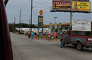
Officials in Galveston County
(which includes the city of Galveston
), which was devastated by the Galveston Hurricane of 1900
, ordered mandatory evacuations, effective September 21 at 6 p.m., in a staggered sequence. Officials designated geographical zones in the area to facilitate an orderly evacuation. People were scheduled to leave at different times over a 24 hour period depending on the zone in which the people were located. The scheduled times were set well in advance of the storm's possible landfall later in the week, but not soon enough to ensure that all residents could evacuate safely in advance of the storm.
Nonetheless, many residents remained in the county because they were either unaware of the danger of the storm or believed that it was more important to protect their belongings, particularly in the wake of looting
following Hurricane Katrina.
The evacuation included transfer of all inpatients from the University of Texas Medical Branch hospital to other regional hospitals.
400 patients were prisoners under the ward of the Texas Department of Corrections.
These patients were systematically transferred to the University of Texas Health Center at Tyler.
Officials of Harris County hoped that the designation of zones A, B, and C would help prevent bottlenecks in traffic leaving the area similar to those seen at New Orleans prior to Katrina
and Hurricane Dennis
earlier that year.
Also, people in certain zones were to be forced to go to certain cities in Texas and were not allowed to exit their designated routes except for food and gas — another feature of the evacuation plan which officials hoped would keep traffic flow orderly.
The evacuation-destination cities included Austin
, College Station
, San Antonio
, Dallas
, Huntsville
, and Lufkin
, Texas. Evacuees were asked to try hotels in the Midland
/Odessa
area when hotels began to sell out in other areas.
 On Wednesday, Houston mayor Bill White urged residents to evacuate the city, telling residents, "Don't wait; the time for waiting is over," reminding residents of the disaster in New Orleans.
After heavy traffic snarled roads leading out of town and gas shortages left numerous vehicles stranded, Mayor White backed off his earlier statement with, "If you're not in the evacuation zone, follow the news," advising people to use common sense. However by 3:00 p.m. that afternoon, the freeway system in Houston was at a stand-still.
To the east of Houston, officials had set up evacuation routes in response to the slow evacuation of residents prior to Hurricane Lili
.
During the Rita evacuation, these preparations and their execution were overwhelmed by the enormous and unprecedented number of people fleeing from the Houston area prior to the departure of local residents. By the time Jefferson County began their mandatory evacuation, local roads were already full of Houstonians.
Traffic on designated evacuation routes was forced to go far slower than the speeds experienced with any previous hurricane.
By late Thursday (22nd) morning, the contraflow lanes had been ordered opened after officials determined that the state's highway system had become gridlock
ed.
The Texas Department of Transportation was unprepared to execute such a large-scale evacuation.
Coordination and implementation of the contraflow plan took 8 to 10 hours as inbound traffic was forced to exit. Police were stationed to assist with traffic flow. Evacuees fought traffic Wednesday afternoon through mid-day Friday, moving only a fraction of the normal distance expected. Average travel times to Dallas were 24–36 hours, travel times to Austin were 12–18 hours and travel times to San Antonio were 10–16 hours, depending on the point of departure in Houston.
Many motorists ran out of gas or experienced breakdowns in temperatures that neared 100 °F (38 °C). Traffic volumes did not ease for nearly 48 hours as more than three million residents evacuated the area in advance of the storm. This was the largest evacuation in U.S. history.
As part of the evacuation, Johnson Space Center in Houston handed off control of the International Space Station
to their Russian
counterparts.
Concerns had been raised over the state of the oil industry in response to Rita. The storm threatened a large amount of oil infrastructure that was left undamaged by Katrina
. The Texas Gulf Coast is home to 23% of the United States' refining capacity, and numerous offshore production platforms were in Rita's path. A direct strike on Houston could disable more than a quarter of the United States' fuel-making capacity.
Valero Energy Corp, the nation's largest refiner, stated on September 21 that Rita could have caused gasoline prices to rise well above $
3 per US gallon
($0.79/L), at a time when the U.S. average price was $2.77/gal.
 In some areas, the effects of Hurricane Rita were not nearly as severe as anticipated. The storm surge
feared in Galveston and Houston struck farther east as the storm's center came ashore at the Louisiana border; winds blowing offshore in Texas actually flattened the surge, which was only seven feet (2 m), well below the height of the Galveston seawall
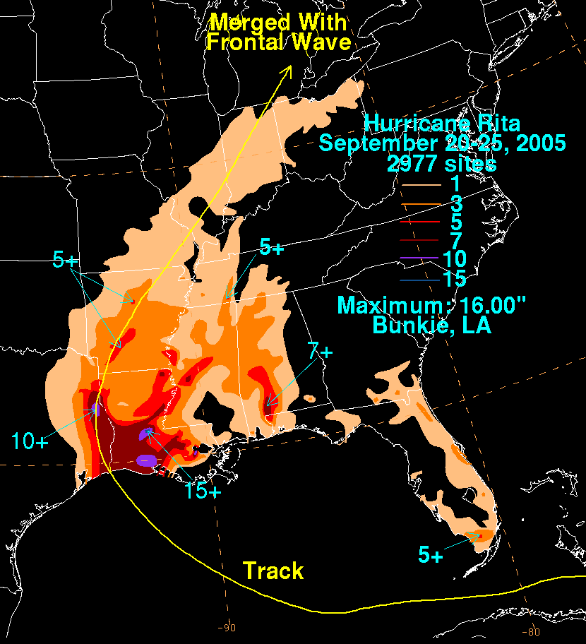
. The five inches (130 mm) of rain expected to fall overnight in New Orleans also did not happen, and the pressure on the levee system was eased. Still, storm surge of 17 feet (3.2 m) struck southwestern Louisiana, and coastal parishes experienced extensive damage. In Cameron Parish
the communities of Holly Beach
, Hackberry
, Cameron
, Creole and Grand Chenier were essentially destroyed. In Calcasieu Parish
the communities of Lake Charles
, Moss Bluff
, Sulphur
, Westlake
, Vinton
and DeQuincy
also suffered heavy damage. In Beauregard Parish
the communities of DeRidder and Merryville
also suffered heavy damage.
An estimated two million people lost electricity
. Total damage is estimated at approximately $10 billion, making Rita the ninth-costliest storm in U.S. history.
Following Rita, gas prices fell in the U.S instead of rising as feared.
The reported death toll for Hurricane Rita was 120. Only seven were direct deaths. One was caused by a tornado spawned in the storm's outer bands, one was due to storm surge flooding and three others were caused by trees blown down in the storm. The two Florida deaths both occurred in rip current
s caused by Rita's distant waves.
Direct deaths are those caused by the direct effects of the winds
, flood
ing, tornadoes, storm surge
or ocean
ic effects of Rita. Indirect deaths are caused by hurricane-related accidents (including car
accidents, crime
s, fire
s or other incidents), cleanup and evacuation incidents and health issues (such as poison
ing, illness
es, lack of emergency aid).
The tornadoes were unusual in that they moved in a northwestern direction due to the direction in which Rita was moving. Most tornadoes move northeast.
No deaths caused by Rita were reported in Arkansas.
and Cuba
. Storm surge flood
ing was reported along the low-lying Florida Keys
. The Overseas Highway
(U.S. 1) connecting the islands was flooded and impassable in some sections. At 8 p.m. EDT on Tuesday, September 20, about 25,000 customers in Broward
and Miami-Dade
and 2,100 in the Keys were without electricity
.
A state of emergency
was declared by Florida Governor Jeb Bush
and a federal emergency by President
George W. Bush
in four counties: Broward, Collier
, Miami-Dade and Monroe
. More than 2,000 National Guard
troops and dozens of law enforcement officers were brought in.
In 2006, during the 17th season of The Real World
, entitled Key West
the cast was shown evacuating out of their Key West
home to Fort Lauderdale, Florida
. This was the second hurricane that seasons cast had to evacuated from. The other two hurricanes they had to evacuate from was Hurricane Katrina
and Hurricane Wilma
.
No deaths were reported in either Florida
or Cuba
from the initial impact.
escaped most of the land effects from Rita, two deaths were reported on beaches. Both were due to high surf and rip currents caused by Rita's distant waves.
 Damage in southwestern Louisiana was extensive. In Cameron Parish, the communities of Hackberry
, Cameron, Creole, Grand Chenier
, Holly Beach
, and Johnson Bayou were heavily damaged or entirely destroyed. A casino
boat and several barges were floating loose in Lake Charles
and damaged a bridge spanning Interstate 10
across the Calcasieu River
. Lake Charles experienced severe flood
ing, with reports of water rising 6–8 feet in areas around Lake Calcasieu. At a hotel on the Contraband Bayou
, water was reportedly up to the second floor. There was also extensive damage to its regional airport. Damage to the city's electrical system was so severe that authorities warned that power would not return for two weeks, if not longer.
In Vinton
, several fires burned, the roof was torn off the town's recreation center and many homes were damaged by fallen trees. Widespread flood
ing was reported in coastal parish
es. In Terrebonne Parish
, virtually every levee was breached. Some people were stranded in flood
ed communities and had to be rescued by boat. At least 100 people were reported rescued from rooftops, as at least 25 more remained stranded.
Louisiana Governor Kathleen Blanco
reported that 700,000 homes lost power in 41 of the state's 64 parishes
.
 In Vermilion Parish south of Abbeville
, rescue efforts were undertaken for up to 1,000 people stranded by local flooding. On Saturday, September 24, 250 people were rescued.
After being reduced to a tropical storm, Rita entered DeSoto and Caddo Parishes
. The eye passed just west of Downtown Shreveport before crossing the Arkansas
border. At the height of the storm over 175,000 people had lost power in the National Weather Service
Shreveport's forecast area, mainly across Deep East Texas into northwest Louisiana. Two fatalities occurred in the Ark-La-Tex
. A tree fell on one person; the other fatality occurred when a teenager was electrocuted when picking up a "hot" power line. Shreveport recorded its 2nd lowest pressure ever recorded as the center of Rita moved through Shreveport around 6 pm Saturday evening. The pressure recorded was 29.05 inches (983.7 mb) which was only .01 inch higher than the lowest pressure on record of 29.04 inches back on February 27, 1902.
in central Mississippi. Another tornado (unconfirmed) was reported in Bolivar County
.
One death was reported in Wilkinson County
, although it has not been confirmed if it was storm-related.
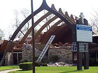
A tornado touched down on Mississippi State University
's (MSU) campus. MSU officials reported significant damage to some buildings. Numerous mobile homes were damaged at the University Hills trailer park just off the campus. There were several non-life threatening injuries.
Lauderdale County in east central Mississippi reported several confirmed and unconfirmed tornado touch downs in and near the cities of Marion and Meridian, an area recovering from damage from Category 2 winds in Hurricane Katrina.

 On the morning of September 23, 23 people were killed when a bus
carrying 45 nursing home evacuees from Brighton Gardens in Bellaire, Texas
erupted into flames and exploded on Interstate 45
in Wilmer
, southeast of Dallas
. The fire started in the brake system, and the passengers' therapeutic oxygen tanks may have caused the bus to explode. Many of the passengers were mobility-impaired making escape difficult or impossible.
In the late evening, a fire broke out in the Strand Historic District of Galveston, Texas
, gutting several homes. However, the fire department
was able to fight the wind-whipped blaze and prevent it from spreading through the city. No serious injuries were reported in the fire. Around midnight one wall of a vacant restaurant, Yaga's Cafe and Bar, collapsed nearby, which was reportedly as a result of the fire that weakened the walls.
 Communities in the "Golden Triangle" formed by Beaumont
, Port Arthur
, and Orange
sustained enormous wind damage. Texas Governor Rick Perry declared a nine-county disaster area. In Beaumont an estimated 25% of the trees in the heavily wooded neighborhoods were uprooted. In Groves
, the home of Texas's Pecan Festival, an equal number of the pecan trees were leveled. An enormous number of houses and businesses suffered extensive damage from wind and falling trees. The water treatment plant in Port Neches
was heavily damaged. Some areas did not have power for more than six weeks.
A mandatory evacuation had been issued before Rita's landfall. Those displaced by Rita were offered up to 60 days of hotel rooms, generators, chainsaws, and monetary assistance by FEMA. The "Golden Triangle" area was spared a more devastating storm surge by Rita's slight eastward turn just before landfall, which placed most of the coastal community to the left of the eye and in the storm's least-damaging quadrant. Rita's surge was contained by Port Arthur's extensive levee system. Bolivar Peninsula between Galveston
and Sabine Pass
experienced only a small storm surge, in contrast to areas east of Rita's center where a 20 feet (6.1 m) surge struck Louisiana's unprotected towns.
The county of Jasper, Texas was also greatly affected. Jasper County is located near the Sabine River, near the Louisiana and Texas border. Known as the "Jewel of the Forest", the county lost many of its pine trees when Rita came through, leveling most of them down to the stump. Jasper County residents were running out of gas and many relied on the only news available at the time from Mike Lout, local radio station owner, who stayed on the air during the entire time of the storm. Many families lost their homes of many years, returning to see that they were crushed by one or more trees.
For the most part, Houston
escaped major damage, apart from extensive loss of power. Some windows blew out of some downtown
skyscrapers, and some trees and signals were down. Thirty one deaths have been reported in Harris County
, of which all of them were indirect (mostly related to the evacuation and cleanup).
North of Houston, the 2.5 miles (4 km)-wide Lake Livingston
dam
sustained substantial damage from powerful waves driven by 117 mph winds and officials started an emergency release of water to lessen pressure on the dam. A number of news outlets reported on Sunday, September 25, 2005, that the discharge put lives at risk downstream and threatened a major bridge as well due to a sizable barge coming adrift. Repairs to the dam were expected to take months to complete. After water levels were lowered and an inspection was conducted by national and local experts, the dam was declared stable late on Monday, September 26, 2005.
 The heavy concentration of oil infrastructure in the Gulf of Mexico makes hurricanes of Rita's intensity very problematic. Currently, very little spare crude oil capacity exists in the United States, and the Gulf of Mexico produces some 2 Moilbbl per day total, as well as having some 30% of the total refining capacity of the United States. Rita's path traveled through a dense area of offshore pipelines and oil platform
s, and on land to an area with large refineries. With over half of Gulf production still shut down in the wake of Katrina, some economists have stated that a worst case scenario is for gasoline prices to briefly touch $5/US gallon ($1.30/L), which would be easily the highest real price for gasoline paid in the United States during the internal combustion era. However the oil industry escaped essentially unscathed from the storm and post-storm predictions estimated only minor price rises. With some 200,000 jobless claims
attributed to Katrina, Rita may have been a further drag on a weakened US economy.
The most pessimistic projections had GDP growth cut by 1% on an annualized basis in the United States in the second half of 2005, with as many as 500,000 people made unemployed. Some economists argued that the rebuilding effort could buoy the economy in 2006, while others argued that the energy spike could decrease consumer confidence by enough to send the economy into a full-fledged recession
when combined with the Federal Reserve's recent increases in interest rates. While the above did happen, it did not occur until 2008, over a year after Rita's impact.
Due to the impending oil shortage and increasing gas prices, Georgia Governor Sonny Perdue
declared what he termed "snow days," closing all Georgia public primary and secondary schools on September 26 and 27 to conserve fuel for buses.
 On September 24, 2005, following the havoc caused by Hurricanes Katrina
and Rita, the National Guard
named Brig. Gen. Douglas Pritt of the 41st Brigade Combat Team
, Oregon
Army
National Guard, head of Joint Task Force Rita (formally called JTF Ponchartrain). The 1,400 Oregonian soldiers and airmen, including the 1st Battalion of the 186th Infantry which is designated a quick response unit, are joined by engineers and military police
from Louisiana, a Stryker
brigade from Pennsylvania
, and an engineering battalion from Missouri
. It is their mission to provide relief support for all of the areas in Texas and Louisiana affected by the two storms and to remove obstructions that might otherwise hinder help to those affected.
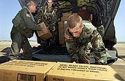
. The Red Cross also expanded their Hurricane Katrina internet "Safe List" for use by those affected by Hurricane Rita.
sent several crews to Texas, Mississippi and Louisiana in response to Hurricane Katrina
and Hurricane Rita. The crews originated from two main organizations, the National Civilian Community Corps
(NCCC) and the Washington Conservation Corps (WCC), as well as from smaller Americorps organizations such as Americorps St. Louis' Emergency Response Team (ERT). The crews performed a number of relief tasks for hurricane survivors, including support on the Federal Emergency Management Agency
(FEMA)/Carnival Cruise Lines
shelter ship, tarping damaged roofs, and debris removal. As of the beginning of 2006, AmeriCorps teams have been involved in the rebuilding efforts in Louisiana and Mississippi. Teams have also operated volunteer camps like Camp Premier as well as assisted with the Made with Love cafe. As of May 2006, AmeriCorps reported that it would continue to send relief to affected areas.
's list.
" (the seventeenth name in the list each season) been used for an Atlantic storm, in 1995
for Hurricane Roxanne
. The formation of Rita actually marked the third time that seventeen storms had formed in a season since tropical storm naming began in 1950. However, in the 1969 season
, many tropical storms were not named; the seventeenth storm of 1969 was named Hurricane Martha.
Other records set by Rita:
The NHC's archive on Hurricane Rita
The HPC's archive on Tropical Depression Rita
The HPC's rainfall page for Rita
Hurricane Rita: from wreckage to rebirth, from The Beaumont Enterprise
NewsNow.co.uk's Hurricane Watch newsfeed
The Disaster Center's Rita coverage
TAOS Autorun - Real-time damage estimates
Hurricane Rita Supply Availability Map
"The Oil Drum: Rita Resource Page for Oil and Natural Gas Infrastructure Damage" The Oil Drum: Rita Oil and Gas Resources
Research Model Advances Hurricane Intensity Prediction
Increasing destructiveness of tropical cyclones
Changes in Tropical Cyclone Number, Duration, and Intensity in a Warming Environment
Beyond Katrina - Hurricanes Rita and Katrina, continuing recovery news, information, and resources five years post
Science Magazine Katrina/Rita page
Color Enhanced Infrared Satellite Video of Hurricane Rita
Hurricane Digital Memory Bank Preserving the Stories of Katrina, Rita, and Wilma
Workforce Redevelopment in the Gulf Coast
Hurricanes Katrina & Rita Web Archive
Tropical cyclone
A tropical cyclone is a storm system characterized by a large low-pressure center and numerous thunderstorms that produce strong winds and heavy rain. Tropical cyclones strengthen when water evaporated from the ocean is released as the saturated air rises, resulting in condensation of water vapor...
ever observed in the Gulf of Mexico
Gulf of Mexico
The Gulf of Mexico is a partially landlocked ocean basin largely surrounded by the North American continent and the island of Cuba. It is bounded on the northeast, north and northwest by the Gulf Coast of the United States, on the southwest and south by Mexico, and on the southeast by Cuba. In...
. Rita caused $11.3 billion in damage on the U.S. Gulf Coast
Gulf Coast of the United States
The Gulf Coast of the United States, sometimes referred to as the Gulf South, South Coast, or 3rd Coast, comprises the coasts of American states that are on the Gulf of Mexico, which includes Texas, Louisiana, Mississippi, Alabama, and Florida and are known as the Gulf States...
in September 2005. Rita was the seventeenth named storm, tenth hurricane, fifth major hurricane, and third Category 5 hurricane of the historic 2005 Atlantic hurricane season
2005 Atlantic hurricane season
The 2005 Atlantic hurricane season was the most active Atlantic hurricane season in recorded history, repeatedly shattering numerous records. The impact of the season was widespread and ruinous with an estimated 3,913 deaths and record damage of about $159.2 billion...
.
Rita made landfall on September 23 between Sabine Pass, Texas
Sabine Pass, Texas
Sabine Pass is a neighborhood of Port Arthur, Texas, United States. It lies on the west bank of Sabine Pass, near the Louisiana border.Originally known as Sabine City, the original date of settlement of Sabine Pass is unknown, but is estimated at 1836...
, and Johnsons Bayou, Louisiana, as a Category 3 hurricane on the Saffir-Simpson Hurricane Scale
Saffir-Simpson Hurricane Scale
The Saffir–Simpson Hurricane Scale , or the Saffir–Simpson Hurricane Wind Scale , classifies hurricanes — Western Hemisphere tropical cyclones that exceed the intensities of tropical depressions and tropical storms — into five categories distinguished by the intensities of their sustained winds...
with 120 mph winds according to the Tropical Cyclone Report. It continued on through parts of southeast Texas. The storm surge
Storm surge
A storm surge is an offshore rise of water associated with a low pressure weather system, typically tropical cyclones and strong extratropical cyclones. Storm surges are caused primarily by high winds pushing on the ocean's surface. The wind causes the water to pile up higher than the ordinary sea...
caused extensive damage along the Louisiana and extreme southeastern Texas
Texas
Texas is the second largest U.S. state by both area and population, and the largest state by area in the contiguous United States.The name, based on the Caddo word "Tejas" meaning "friends" or "allies", was applied by the Spanish to the Caddo themselves and to the region of their settlement in...
coasts and destroyed some coastal communities. The storm killed seven people directly; many others died in evacuations and from indirect effects.
Meteorological history
The storm system that became Rita formed at the tail of an old frontal boundary, where convection and low-level circulation around an upper-level lowLow pressure area
A low-pressure area, or "low", is a region where the atmospheric pressure at sea level is below that of surrounding locations. Low-pressure systems form under areas of wind divergence which occur in upper levels of the troposphere. The formation process of a low-pressure area is known as...
developed steadily for over two days. On September 17 the National Hurricane Center
National Hurricane Center
The National Hurricane Center , located at Florida International University in Miami, Florida, is the division of the National Weather Service responsible for tracking and predicting weather systems within the tropics between the Prime Meridian and the 140th meridian west poleward to the 30th...
concluded that the tropical disturbance had acquired enough convective organization to be classified a tropical depression, and so named it Tropical Depression 18. Located 95 miles (155 km) east-northeast of Grand Turk Island
Grand Turk Island
Grand Turk Island is an island in the Turks and Caicos Islands. It is the largest island in the Turks Islands with . It contains the territory's capital, Cockburn Town and the JAGS McCartney International Airport...
, the system was moving west-northwest, towards Florida
Florida
Florida is a state in the southeastern United States, located on the nation's Atlantic and Gulf coasts. It is bordered to the west by the Gulf of Mexico, to the north by Alabama and Georgia and to the east by the Atlantic Ocean. With a population of 18,801,310 as measured by the 2010 census, it...
.
Less than a day after forming, the depression became the 17th tropical storm of the season on September 18 and was named Rita. A mandatory evacuation was ordered for the entire Florida Keys
Florida Keys
The Florida Keys are a coral archipelago in southeast United States. They begin at the southeastern tip of the Florida peninsula, about south of Miami, and extend in a gentle arc south-southwest and then westward to Key West, the westernmost of the inhabited islands, and on to the uninhabited Dry...
.
Rita was slow to become a hurricane; National Hurricane Center
National Hurricane Center
The National Hurricane Center , located at Florida International University in Miami, Florida, is the division of the National Weather Service responsible for tracking and predicting weather systems within the tropics between the Prime Meridian and the 140th meridian west poleward to the 30th...
(NHC) reports early on September 20 estimated the storm's sustained surface winds at hurricane force (75 mph or 120 km/h). However, Rita lacked a complete eyewall; forecasters identified Rita as a tropical storm with 70 mph (110 km/h) winds overnight. Aircraft observations released at 9:45 a.m. EDT showed a closed eyewall and winds clearly at hurricane strength. Four hours later, the NHC reported that Rita had reached Category 2 hurricane strength, with 100 mph (160 km/h) maximum sustained winds.
Warm water in the Gulf of Mexico, 1 °F (0.5 °C) above average, favored storm intensification. As Rita entered the Gulf, rapid intensification began. National Hurricane Center advisories issued every three hours each showed strengthening from 5 p.m. EDT on September 20 to 11 a.m. EDT on September 21, when Rita's maximum sustained winds increased to 140 mph (225 km/h). Rita continued to gain strength unabated. An update at 2:15 p.m. CDT (1815 UTC) said maximum winds had increased to 150 mph (240 km/h) and Rita's minimum pressure was 920 mbar (hPa
Pascal (unit)
The pascal is the SI derived unit of pressure, internal pressure, stress, Young's modulus and tensile strength, named after the French mathematician, physicist, inventor, writer, and philosopher Blaise Pascal. It is a measure of force per unit area, defined as one newton per square metre...
). Less than two hours later, at 3:55 p.m. CDT, another update reported that Rita had strengthened to a Category 5 hurricane, with maximum wind speeds of 165 mph (265 km/h). At 6:50 p.m. CDT, a reconnaissance
Reconnaissance
Reconnaissance is the military term for exploring beyond the area occupied by friendly forces to gain information about enemy forces or features of the environment....
aircraft recorded pressure of 899 mbar (hPa
Pascal (unit)
The pascal is the SI derived unit of pressure, internal pressure, stress, Young's modulus and tensile strength, named after the French mathematician, physicist, inventor, writer, and philosopher Blaise Pascal. It is a measure of force per unit area, defined as one newton per square metre...
) away from the storm's center; the actual central pressure was thought to be lower still. At 10 p.m. CDT, Rita reached its maximum intensity, with sustained winds of 180 mph (290 km/h) and an estimated minimum pressure of 895 mbar (hPa
Pascal (unit)
The pascal is the SI derived unit of pressure, internal pressure, stress, Young's modulus and tensile strength, named after the French mathematician, physicist, inventor, writer, and philosopher Blaise Pascal. It is a measure of force per unit area, defined as one newton per square metre...
), (26.43 in Hg).
Buoy
A buoy is a floating device that can have many different purposes. It can be anchored or allowed to drift. The word, of Old French or Middle Dutch origin, is now most commonly in UK English, although some orthoepists have traditionally prescribed the pronunciation...
-based weather stations.
Rita made landfall between Sabine Pass, Texas
Sabine Pass, Texas
Sabine Pass is a neighborhood of Port Arthur, Texas, United States. It lies on the west bank of Sabine Pass, near the Louisiana border.Originally known as Sabine City, the original date of settlement of Sabine Pass is unknown, but is estimated at 1836...
, and Johnson Bayou, Louisiana, at 02:38 CDT (07:38 UTC) on September 24, 2005 as a Category 3 Hurricane with winds at 120 mph. Rita lost both hurricane and tropical storm status the day of landfall. Rita's remnants — technically an extensive low pressure area — moved quickly out of the lower Mississippi Valley and were absorbed by a cold front. The Hydrometeorological Prediction Center
Hydrometeorological Prediction Center
The Hydrometeorological Prediction Center is one of nine service centers under the umbrella of the National Centers for Environmental Prediction , a part of the National Weather Service, which in turn is part of the National Oceanic and Atmospheric Administration of the U.S. government...
ceased monitoring Tropical Depression Rita early on September 26.
Louisiana
Residents of Cameron ParishCameron Parish, Louisiana
Cameron Parish is the parish with the most land area in the U.S. state of Louisiana. The parish seat is Cameron and as of 2010, the population was 6,839...
, Calcasieu Parish
Calcasieu Parish, Louisiana
Calcasieu Parish[p] is a parish located in the U.S. state of Louisiana. The parish seat is Lake Charles. As of 2010, the parish population was 192,768...
, and parts of Jefferson Davis Parish
Jefferson Davis Parish, Louisiana
Jefferson Davis Parish is a parish located in the U.S. state of Louisiana. The parish seat is Jennings. As of 2000, its population was 31,435. Jefferson Davis Parish is named after the president of the Confederacy during the American Civil War, Jefferson Davis. It is located in southwestern...
, Acadia Parish
Acadia Parish, Louisiana
Acadia Parish is a parish located in the U.S. state of Louisiana. The parish seat is Crowley. According to the 2010 census, the population of Acadia Parish is 61,773. The parish was founded from parts of St...
, Iberia Parish, Beauregard Parish, and Vermillion Parish were told to evacuate ahead of the storm. Cameron Parish was hit the hardest with the towns of Creole, Cameron, Grand Chenier, Johnson's Bayou, and Holly Beach being totally demolished. Records around the Hackberry area show that wind gusts reached over 180 mph at a boat tied up to a dock. The people were told to evacuate by Thursday, September 22, 2005 by 6:00 pm. Two days later, parish officials returned to the Gibbstown Bridge that crosses the Intracoastal Canal into Lower Cameron Parish. No one was known to be left in the parish as of that time on Thursday, September 22, 2005. Almost 5 years later, Lake Charles, Sulphur, Westlake, Mossbluff and Vinton and the parishes mentioned are no where near its prior population with many people having chosen to relocate else where.
Texas
Governor of Texas
The governor of Texas is the head of the executive branch of Texas's government and the commander-in-chief of the state's military forces. The governor has the power to either approve or veto bills passed by the Texas Legislature, and to convene the legislature...
Rick Perry
Rick Perry
James Richard "Rick" Perry is the 47th and current Governor of Texas. A Republican, Perry was elected Lieutenant Governor of Texas in 1998 and assumed the governorship in December 2000 when then-governor George W. Bush resigned to become President of the United States. Perry was elected to full...
recalled all emergency personnel, including almost 1,200 Texas National Guard
Texas National Guard
The Texas National Guard consists of the Texas Army National Guard and the Texas Air National Guard. The Guard is administered by the adjutant general, an appointee of the governor of Texas. The Constitution of the United States specifically charges the National Guard with dual federal and state...
and 1,100 Texas State Guard
Texas State Guard
The Texas State Guard is one of three branches of the military forces of Texas, reporting to the Adjutant General, and under the command of the Governor. The other branches of the State Military Forces of Texas are the Texas Army National Guard, and the Texas Air National Guard.-History:The Texas...
members from Katrina
Hurricane Katrina
Hurricane Katrina of the 2005 Atlantic hurricane season was a powerful Atlantic hurricane. It is the costliest natural disaster, as well as one of the five deadliest hurricanes, in the history of the United States. Among recorded Atlantic hurricanes, it was the sixth strongest overall...
recovery efforts, and several hundred Texas Game Wardens in anticipation of Hurricane Rita's arrival. In addition, the Federal Government responded by deploying 11 Disaster Medical Assistance Teams (DMATs), mobile field hospitals, to stage across eastern Texas. The teams treated 7500 patients during the response.
On September 22, Governor Perry and the Texas Department of Transportation implemented a contraflow lane reversal
Contraflow lane reversal
Contraflow lane reversal refers to plans that alter the normal flow of traffic, typically on a controlled-access highway , to either aid in an emergency evacuation or, as part of routine maintenance activities, to facilitate widening or reconstruction of one of the highway's carriageways...
on Interstate 45
Interstate 45
Interstate 45 is an intrastate Interstate Highway located entirely within the U.S. state of Texas. It connects the cities of Dallas and Houston, continuing southeast from Houston to Galveston over the Galveston Causeway to the Gulf of Mexico...
north towards Dallas
Dallas, Texas
Dallas is the third-largest city in Texas and the ninth-largest in the United States. The Dallas-Fort Worth Metroplex is the largest metropolitan area in the South and fourth-largest metropolitan area in the United States...
, on Interstate 10
Interstate 10
Interstate 10 is the fourth-longest Interstate Highway in the United States, after I-90, I-80, and I-40. It is the southernmost east–west, coast-to-coast Interstate Highway, although I-4 and I-8 are further south. It stretches from the Pacific Ocean at State Route 1 in Santa Monica,...
west towards San Antonio
San Antonio, Texas
San Antonio is the seventh-largest city in the United States of America and the second-largest city within the state of Texas, with a population of 1.33 million. Located in the American Southwest and the south–central part of Texas, the city serves as the seat of Bexar County. In 2011,...
, U.S. Highway 290 northwest to Austin
Austin, Texas
Austin is the capital city of the U.S. state of :Texas and the seat of Travis County. Located in Central Texas on the eastern edge of the American Southwest, it is the fourth-largest city in Texas and the 14th most populous city in the United States. It was the third-fastest-growing large city in...
.
Officials in Galveston County
Galveston County, Texas
Galveston County is a county located in the U.S. state of Texas within the Houston–Sugar Land–Baytown metropolitan area. As of the 2010 U.S. Census, the population was 291,309. Its county seat is Galveston. League City is the largest city in Galveston County in terms of population; between...
(which includes the city of Galveston
Galveston, Texas
Galveston is a coastal city located on Galveston Island in the U.S. state of Texas. , the city had a total population of 47,743 within an area of...
), which was devastated by the Galveston Hurricane of 1900
Galveston Hurricane of 1900
The Hurricane of 1900 made landfall on the city of Galveston in the U.S. state of Texas, on September 8, 1900.It had estimated winds of at landfall, making it a Category 4 storm on the Saffir-Simpson Hurricane Scale...
, ordered mandatory evacuations, effective September 21 at 6 p.m., in a staggered sequence. Officials designated geographical zones in the area to facilitate an orderly evacuation. People were scheduled to leave at different times over a 24 hour period depending on the zone in which the people were located. The scheduled times were set well in advance of the storm's possible landfall later in the week, but not soon enough to ensure that all residents could evacuate safely in advance of the storm.
Nonetheless, many residents remained in the county because they were either unaware of the danger of the storm or believed that it was more important to protect their belongings, particularly in the wake of looting
Looting
Looting —also referred to as sacking, plundering, despoiling, despoliation, and pillaging—is the indiscriminate taking of goods by force as part of a military or political victory, or during a catastrophe, such as during war, natural disaster, or rioting...
following Hurricane Katrina.
The evacuation included transfer of all inpatients from the University of Texas Medical Branch hospital to other regional hospitals.
400 patients were prisoners under the ward of the Texas Department of Corrections.
These patients were systematically transferred to the University of Texas Health Center at Tyler.
Officials of Harris County hoped that the designation of zones A, B, and C would help prevent bottlenecks in traffic leaving the area similar to those seen at New Orleans prior to Katrina
Hurricane Katrina
Hurricane Katrina of the 2005 Atlantic hurricane season was a powerful Atlantic hurricane. It is the costliest natural disaster, as well as one of the five deadliest hurricanes, in the history of the United States. Among recorded Atlantic hurricanes, it was the sixth strongest overall...
and Hurricane Dennis
Hurricane Dennis
Hurricane Dennis was an early-forming major hurricane in the Caribbean and Gulf of Mexico during the very active 2005 Atlantic hurricane season. Dennis was the fourth named storm, second hurricane, and first major hurricane of the season...
earlier that year.
Also, people in certain zones were to be forced to go to certain cities in Texas and were not allowed to exit their designated routes except for food and gas — another feature of the evacuation plan which officials hoped would keep traffic flow orderly.
The evacuation-destination cities included Austin
Austin, Texas
Austin is the capital city of the U.S. state of :Texas and the seat of Travis County. Located in Central Texas on the eastern edge of the American Southwest, it is the fourth-largest city in Texas and the 14th most populous city in the United States. It was the third-fastest-growing large city in...
, College Station
College Station, Texas
College Station is a city in Brazos County, Texas, situated in East Central Texas in the heart of the Brazos Valley. The city is located within the most populated region of Texas, near three of the 10 largest cities in the United States - Houston, Dallas, and San Antonio...
, San Antonio
San Antonio, Texas
San Antonio is the seventh-largest city in the United States of America and the second-largest city within the state of Texas, with a population of 1.33 million. Located in the American Southwest and the south–central part of Texas, the city serves as the seat of Bexar County. In 2011,...
, Dallas
Dallas, Texas
Dallas is the third-largest city in Texas and the ninth-largest in the United States. The Dallas-Fort Worth Metroplex is the largest metropolitan area in the South and fourth-largest metropolitan area in the United States...
, Huntsville
Huntsville, Texas
Huntsville is a city in and the county seat of Walker County, Texas, United States. The population was 35,508 at the 2010 census. It is the center of the Huntsville micropolitan area....
, and Lufkin
Lufkin, Texas
Lufkin is a city in Angelina County, Texas, United States. Founded in 1882, the population was 35,067 in 2010. It is the county seat of Angelina County, and is situated in Deep East Texas.-History:...
, Texas. Evacuees were asked to try hotels in the Midland
Midland, Texas
Midland is a city in and the county seat of Midland County, Texas, United States, on the Southern Plains of the state's western area. A small portion of the city extends into Martin County. As of 2010, the population of Midland was 111,147. It is the principal city of the Midland, Texas...
/Odessa
Odessa, Texas
Odessa is a city in and the county seat of Ector County, Texas, United States. It is located primarily in Ector County, although a small portion of the city extends into Midland County. Odessa's population was 99,940 at the 2010 census. It is the principal city of the Odessa, Texas Metropolitan...
area when hotels began to sell out in other areas.
After heavy traffic snarled roads leading out of town and gas shortages left numerous vehicles stranded, Mayor White backed off his earlier statement with, "If you're not in the evacuation zone, follow the news," advising people to use common sense. However by 3:00 p.m. that afternoon, the freeway system in Houston was at a stand-still.
To the east of Houston, officials had set up evacuation routes in response to the slow evacuation of residents prior to Hurricane Lili
Hurricane Lili
Hurricane Lili was the deadliest and costliest hurricane of the 2002 Atlantic hurricane season for the United States. Lili was the twelfth named storm, fourth hurricane, and second major hurricane of the 2002 Atlantic hurricane season. The storm developed from a tropical disturbance in the open...
.
During the Rita evacuation, these preparations and their execution were overwhelmed by the enormous and unprecedented number of people fleeing from the Houston area prior to the departure of local residents. By the time Jefferson County began their mandatory evacuation, local roads were already full of Houstonians.
Traffic on designated evacuation routes was forced to go far slower than the speeds experienced with any previous hurricane.
By late Thursday (22nd) morning, the contraflow lanes had been ordered opened after officials determined that the state's highway system had become gridlock
Gridlock
The term gridlock is defined as "A state of severe road congestion arising when continuous queues of vehicles block an entire network of intersecting streets, bringing traffic in all directions to a complete standstill; a traffic jam of this kind." The term originates from a situation possible in...
ed.
The Texas Department of Transportation was unprepared to execute such a large-scale evacuation.
Coordination and implementation of the contraflow plan took 8 to 10 hours as inbound traffic was forced to exit. Police were stationed to assist with traffic flow. Evacuees fought traffic Wednesday afternoon through mid-day Friday, moving only a fraction of the normal distance expected. Average travel times to Dallas were 24–36 hours, travel times to Austin were 12–18 hours and travel times to San Antonio were 10–16 hours, depending on the point of departure in Houston.
Many motorists ran out of gas or experienced breakdowns in temperatures that neared 100 °F (38 °C). Traffic volumes did not ease for nearly 48 hours as more than three million residents evacuated the area in advance of the storm. This was the largest evacuation in U.S. history.
As part of the evacuation, Johnson Space Center in Houston handed off control of the International Space Station
International Space Station
The International Space Station is a habitable, artificial satellite in low Earth orbit. The ISS follows the Salyut, Almaz, Cosmos, Skylab, and Mir space stations, as the 11th space station launched, not including the Genesis I and II prototypes...
to their Russian
Russian Federal Space Agency
The Russian Federal Space Agency , commonly called Roscosmos and abbreviated as FKA and RKA , is the government agency responsible for the Russian space science program and general aerospace research. It was previously the Russian Aviation and Space Agency .Headquarters of Roscosmos are located...
counterparts.
Concerns had been raised over the state of the oil industry in response to Rita. The storm threatened a large amount of oil infrastructure that was left undamaged by Katrina
Hurricane Katrina
Hurricane Katrina of the 2005 Atlantic hurricane season was a powerful Atlantic hurricane. It is the costliest natural disaster, as well as one of the five deadliest hurricanes, in the history of the United States. Among recorded Atlantic hurricanes, it was the sixth strongest overall...
. The Texas Gulf Coast is home to 23% of the United States' refining capacity, and numerous offshore production platforms were in Rita's path. A direct strike on Houston could disable more than a quarter of the United States' fuel-making capacity.
Valero Energy Corp, the nation's largest refiner, stated on September 21 that Rita could have caused gasoline prices to rise well above $
United States dollar
The United States dollar , also referred to as the American dollar, is the official currency of the United States of America. It is divided into 100 smaller units called cents or pennies....
3 per US gallon
Gallon
The gallon is a measure of volume. Historically it has had many different definitions, but there are three definitions in current use: the imperial gallon which is used in the United Kingdom and semi-officially within Canada, the United States liquid gallon and the lesser used United States dry...
($0.79/L), at a time when the U.S. average price was $2.77/gal.
Impact
Storm surge
A storm surge is an offshore rise of water associated with a low pressure weather system, typically tropical cyclones and strong extratropical cyclones. Storm surges are caused primarily by high winds pushing on the ocean's surface. The wind causes the water to pile up higher than the ordinary sea...
feared in Galveston and Houston struck farther east as the storm's center came ashore at the Louisiana border; winds blowing offshore in Texas actually flattened the surge, which was only seven feet (2 m), well below the height of the Galveston seawall
Seawall
A seawall is a form of coastal defence constructed where the sea, and associated coastal processes, impact directly upon the landforms of the coast. The purpose of a seawall is to protect areas of human habitation, conservation and leisure activities from the action of tides and waves...
. The five inches (130 mm) of rain expected to fall overnight in New Orleans also did not happen, and the pressure on the levee system was eased. Still, storm surge of 17 feet (3.2 m) struck southwestern Louisiana, and coastal parishes experienced extensive damage. In Cameron Parish
Cameron Parish, Louisiana
Cameron Parish is the parish with the most land area in the U.S. state of Louisiana. The parish seat is Cameron and as of 2010, the population was 6,839...
the communities of Holly Beach
Holly Beach, Louisiana
Holly Beach , also known as the "Cajun Riviera" , is a coastal community in unincorporated Cameron Parish, Louisiana, United States.Known for crabbing and a drive on the beach, this small Southwest Louisiana community mainly consisted of beach-front cabins called "camps" which, due to the threat of...
, Hackberry
Hackberry, Louisiana
Hackberry is a census-designated place in Cameron Parish, Louisiana, United States. The population was 1,699 at the 2000 census. It is part of the Lake Charles Metropolitan Statistical Area.-Geography:Hackberry is located at ....
, Cameron
Cameron, Louisiana
Cameron is a census-designated place in and the parish seat of Cameron Parish, Louisiana, United States. The population was 1,965 at the 2000 census. It is part of the Lake Charles Metropolitan Statistical Area...
, Creole and Grand Chenier were essentially destroyed. In Calcasieu Parish
Calcasieu Parish, Louisiana
Calcasieu Parish[p] is a parish located in the U.S. state of Louisiana. The parish seat is Lake Charles. As of 2010, the parish population was 192,768...
the communities of Lake Charles
Lake Charles, Louisiana
Lake Charles is the fifth-largest incorporated city in the U.S. state of Louisiana, located on Lake Charles, Prien Lake, and the Calcasieu River. Located in Calcasieu Parish, a major cultural, industrial, and educational center in the southwest region of the state, and one of the most important in...
, Moss Bluff
Moss Bluff, Louisiana
Moss Bluff is a census-designated place in Calcasieu Parish, Louisiana, United States. The population was 10,535 at the 2000 census. Located just north of the city of Lake Charles, it is considered a suburb of that city. Moss Bluff is a burgeoning community, and is one of the communities in...
, Sulphur
Sulphur, Louisiana
Sulphur is a city in Calcasieu Parish, Louisiana, United States. The population was 22,512 at the 2000 census. Sulphur is a suburb of Lake Charles, and is part of the Lake Charles Metropolitan Statistical Area.-History:...
, Westlake
Westlake, Louisiana
Westlake is a city in Calcasieu Parish, Louisiana, United States and is part of the Lake Charles Metropolitan Statistical Area. It is considered a suburb of Lake Charles. The population was 4,668 at the 2000 census...
, Vinton
Vinton, Louisiana
Vinton is a town in Calcasieu Parish, Louisiana, United States. The population was 3,338 at the 2000 census. It is part of the Lake Charles Metropolitan Statistical Area.-History of Vinton:...
and DeQuincy
DeQuincy, Louisiana
DeQuincy is the northernmost city in Calcasieu Parish, Louisiana, United States. The population was 3,398 at the 2000 census. DeQuincy is part of the Lake Charles Metropolitan Statistical Area.-Geography:DeQuincy is located at ....
also suffered heavy damage. In Beauregard Parish
Beauregard Parish, Louisiana
Beauregard Parish [p] is a parish located in the U.S. state of Louisiana. Beauregard Parish was formed on 1 January 1913. The parish seat is DeRidder. As of 2000, the population was 32,986. Beauregard Parish is part of the DeRidder Micropolitan Statistical Area as well as the Fort Polk...
the communities of DeRidder and Merryville
Merryville, Louisiana
Merryville is a town in Beauregard Parish, Louisiana, United States. The population was 1,126 at the 2000 census. It is part of the DeRidder Micropolitan Statistical Area.-Geography:Merryville is located at ....
also suffered heavy damage.
An estimated two million people lost electricity
Electricity
Electricity is a general term encompassing a variety of phenomena resulting from the presence and flow of electric charge. These include many easily recognizable phenomena, such as lightning, static electricity, and the flow of electrical current in an electrical wire...
. Total damage is estimated at approximately $10 billion, making Rita the ninth-costliest storm in U.S. history.
Following Rita, gas prices fell in the U.S instead of rising as feared.
Deaths
| State | State total | County/Parish | Reported deaths | Direct deaths |
|---|---|---|---|---|
| Florida Florida Florida is a state in the southeastern United States, located on the nation's Atlantic and Gulf coasts. It is bordered to the west by the Gulf of Mexico, to the north by Alabama and Georgia and to the east by the Atlantic Ocean. With a population of 18,801,310 as measured by the 2010 census, it... |
2 | Escambia Escambia County, Florida Escambia County is the westernmost county in the U.S. state of Florida. The 2010 population was 297,619. The U.S. Census Bureau 2005 estimate for the county is 296,772. Its county seat is Pensacola.- History :... |
1 | 1 |
| Walton Walton County, Florida Walton County is a county located in the state of Florida. As of 2000, the population was 40,601. The U.S. Census Bureau 2005 estimate for the county is 50,324. Its county seat is DeFuniak Springs, Florida. The county is home to the highest natural point in Florida: Britton Hill, at .- History... |
1 | 1 | ||
| Louisiana Louisiana Louisiana is a state located in the southern region of the United States of America. Its capital is Baton Rouge and largest city is New Orleans. Louisiana is the only state in the U.S. with political subdivisions termed parishes, which are local governments equivalent to counties... |
1 | Calcasieu Calcasieu Parish, Louisiana Calcasieu Parish[p] is a parish located in the U.S. state of Louisiana. The parish seat is Lake Charles. As of 2010, the parish population was 192,768... |
1 | 1 |
| Mississippi Mississippi Mississippi is a U.S. state located in the Southern United States. Jackson is the state capital and largest city. The name of the state derives from the Mississippi River, which flows along its western boundary, whose name comes from the Ojibwe word misi-ziibi... |
4 | Humphreys Humphreys County, Mississippi -Demographics:At the 2000 census, there were 11,206 people, 3,765 households and 2,695 families residing in the county. The population density was 27 per square mile . There were 4,138 housing units at an average density of 10 per square mile... |
1 | 1 |
| Pike Pike County, Mississippi -Demographics:As of the census of 2000, there were 38,940 people, 14,792 households, and 10,502 families residing in the county. The population density was 95 people per square mile . There were 16,720 housing units at an average density of 41 per square mile... |
3 | 0 | ||
| Texas Texas Texas is the second largest U.S. state by both area and population, and the largest state by area in the contiguous United States.The name, based on the Caddo word "Tejas" meaning "friends" or "allies", was applied by the Spanish to the Caddo themselves and to the region of their settlement in... |
113 | Angelina Angelina County, Texas Angelina County is a county located in the U.S. state of Texas. Angelina County was formed in 1846 from Nacogdoches County. As of 2000, the population was 80,130. Its county seat is Lufkin. Angelina is named for a Hainai Native American woman who assisted early Spanish missionaries and was named... |
2 | 1 |
| Dallas Dallas County, Texas As of the census of 2000, there were 2,218,899 people, 807,621 households, and 533,837 families residing in the county. The population density was 2,523 people per square mile . There were 854,119 housing units at an average density of 971/sq mi... |
23 | 0 | ||
| Galveston Galveston County, Texas Galveston County is a county located in the U.S. state of Texas within the Houston–Sugar Land–Baytown metropolitan area. As of the 2010 U.S. Census, the population was 291,309. Its county seat is Galveston. League City is the largest city in Galveston County in terms of population; between... |
36 | 0 | ||
| Harris Harris County, Texas As of the 2010 Census, the population of the county was 4,092,459, White Americans made up 56.6% of Harris County's population; non-Hispanic whites represented 33.0% of the population. Black Americans made up 18.9% of the population. Native Americans made up 0.7% of Harris County's population... |
35 | 0 | ||
| Jefferson Jefferson County, Texas Jefferson County is a county located in the state of Texas, United States. As of 2000, the population was 252,051. Its county seat is Beaumont, and it is named for the former U.S... |
6 | 0 | ||
| Liberty Liberty County, Texas Liberty County is a county located in Texas within the Houston–Sugar Land–Baytown metropolitan area. As of the 2010 United States Census, the population was 75,643. Its county seat is Liberty.-Geography:According to the U.S... |
2 | 2 | ||
| Montgomery Montgomery County, Texas Montgomery County is a county located in the U.S. state of Texas within the Houston–Sugar Land–Baytown metropolitan area. The county was created by an act of the Congress of the Republic of Texas on December 14, 1837. The county was named for the town of Montgomery, Texas. In 2000, its... |
2 | 0 | ||
| Shelby Shelby County, Texas *Arcadia*Brooklyn*Center*Dreka *Huxley*Joaquin*Possum Trot*Shelbyville *Tenaha*Timpson*Weaver-Education:The following school districts serve Shelby County:*Center ISD*Excelsior ISD... |
1 | 0 | ||
| Walker Walker County, Texas Walker County is a county located in the U.S. state of Texas. In 2010, its population was 67,861. Its county seat is Huntsville.Initially, Walker County was named for Robert J. Walker, a legislator from Mississippi who introduced into the United States Congress the resolution to annex Texas... |
5 | 0 | ||
| Totals | 120 | 120 | 7 | |
| Because of differing sources, totals may not match. | ||||
The reported death toll for Hurricane Rita was 120. Only seven were direct deaths. One was caused by a tornado spawned in the storm's outer bands, one was due to storm surge flooding and three others were caused by trees blown down in the storm. The two Florida deaths both occurred in rip current
Rip current
A rip current, commonly referred to by the misnomer rip tide, is a strong channel of water flowing seaward from near the shore, typically through the surf line. Typical flow is at 0.5 metres per second , and can be as fast as 2.5 metres per second...
s caused by Rita's distant waves.
Direct deaths are those caused by the direct effects of the winds
WINDS
WINDS , is a Japanese communication satellite. Launch was originally scheduled for 2007. The launch date was eventually set for 15 February 2008, however a problem detected in a second stage manoeuvring thruster delayed it to 23 February...
, flood
Flood
A flood is an overflow of an expanse of water that submerges land. The EU Floods directive defines a flood as a temporary covering by water of land not normally covered by water...
ing, tornadoes, storm surge
Storm surge
A storm surge is an offshore rise of water associated with a low pressure weather system, typically tropical cyclones and strong extratropical cyclones. Storm surges are caused primarily by high winds pushing on the ocean's surface. The wind causes the water to pile up higher than the ordinary sea...
or ocean
Ocean
An ocean is a major body of saline water, and a principal component of the hydrosphere. Approximately 71% of the Earth's surface is covered by ocean, a continuous body of water that is customarily divided into several principal oceans and smaller seas.More than half of this area is over 3,000...
ic effects of Rita. Indirect deaths are caused by hurricane-related accidents (including car
Automobile
An automobile, autocar, motor car or car is a wheeled motor vehicle used for transporting passengers, which also carries its own engine or motor...
accidents, crime
Crime
Crime is the breach of rules or laws for which some governing authority can ultimately prescribe a conviction...
s, fire
Fire
Fire is the rapid oxidation of a material in the chemical process of combustion, releasing heat, light, and various reaction products. Slower oxidative processes like rusting or digestion are not included by this definition....
s or other incidents), cleanup and evacuation incidents and health issues (such as poison
Poison
In the context of biology, poisons are substances that can cause disturbances to organisms, usually by chemical reaction or other activity on the molecular scale, when a sufficient quantity is absorbed by an organism....
ing, illness
Illness
Illness is a state of poor health. Illness is sometimes considered another word for disease. Others maintain that fine distinctions exist...
es, lack of emergency aid).
Arkansas
While Rita weakened to a tropical depression, the outer bands continued to spawn numerous tornadoes in Arkansas, including one in Lonoke County and another in Conway County, damaging many homes and businesses in several communities. In addition, significant flooding was reported in several areas.The tornadoes were unusual in that they moved in a northwestern direction due to the direction in which Rita was moving. Most tornadoes move northeast.
No deaths caused by Rita were reported in Arkansas.
South Florida and Cuba
More than 340,000 people were under voluntary or mandatory evacuation orders in FloridaFlorida
Florida is a state in the southeastern United States, located on the nation's Atlantic and Gulf coasts. It is bordered to the west by the Gulf of Mexico, to the north by Alabama and Georgia and to the east by the Atlantic Ocean. With a population of 18,801,310 as measured by the 2010 census, it...
and Cuba
Cuba
The Republic of Cuba is an island nation in the Caribbean. The nation of Cuba consists of the main island of Cuba, the Isla de la Juventud, and several archipelagos. Havana is the largest city in Cuba and the country's capital. Santiago de Cuba is the second largest city...
. Storm surge flood
Flood
A flood is an overflow of an expanse of water that submerges land. The EU Floods directive defines a flood as a temporary covering by water of land not normally covered by water...
ing was reported along the low-lying Florida Keys
Florida Keys
The Florida Keys are a coral archipelago in southeast United States. They begin at the southeastern tip of the Florida peninsula, about south of Miami, and extend in a gentle arc south-southwest and then westward to Key West, the westernmost of the inhabited islands, and on to the uninhabited Dry...
. The Overseas Highway
Overseas Highway
The Overseas Highway is a highway carrying U.S. Route 1 through the Florida Keys. Large parts of it were built on the former right-of-way of the Overseas Railroad, the Key West Extension of the Florida East Coast Railway. Completed in 1912, the Overseas Railroad was heavily damaged and partially...
(U.S. 1) connecting the islands was flooded and impassable in some sections. At 8 p.m. EDT on Tuesday, September 20, about 25,000 customers in Broward
Broward County, Florida
-2000 Census:As of the census of 2000, there were 1,623,018 people, 654,445 households, and 411,645 families residing in the county. The population density was 1,346 people per square mile . There were 741,043 housing units at an average density of 615 per square mile...
and Miami-Dade
Miami-Dade County, Florida
Miami-Dade County is a county located in the southeastern part of the state of Florida. As of 2010 U.S. Census, the county had a population of 2,496,435, making it the most populous county in Florida and the eighth-most populous county in the United States...
and 2,100 in the Keys were without electricity
Electricity
Electricity is a general term encompassing a variety of phenomena resulting from the presence and flow of electric charge. These include many easily recognizable phenomena, such as lightning, static electricity, and the flow of electrical current in an electrical wire...
.
A state of emergency
State of emergency
A state of emergency is a governmental declaration that may suspend some normal functions of the executive, legislative and judicial powers, alert citizens to change their normal behaviours, or order government agencies to implement emergency preparedness plans. It can also be used as a rationale...
was declared by Florida Governor Jeb Bush
Jeb Bush
John Ellis "Jeb" Bush is an American politician who served as the 43rd Governor of Florida from 1999 to 2007. He is a prominent member of the Bush family: the second son of former President George H. W. Bush and former First Lady Barbara Bush; the younger brother of former President George W...
and a federal emergency by President
President of the United States
The President of the United States of America is the head of state and head of government of the United States. The president leads the executive branch of the federal government and is the commander-in-chief of the United States Armed Forces....
George W. Bush
George W. Bush
George Walker Bush is an American politician who served as the 43rd President of the United States, from 2001 to 2009. Before that, he was the 46th Governor of Texas, having served from 1995 to 2000....
in four counties: Broward, Collier
Collier County, Florida
Collier County is a county located in the U.S. state of Florida. As of 2000, the population was 251,377. The U.S. Census Bureau 2007 estimate for the county is 315,839...
, Miami-Dade and Monroe
Monroe County, Florida
Monroe County is a county located in the state of Florida. As of 2000, the population was 79,589. The U.S. Census Bureau 2006 estimate for the county was 74,737....
. More than 2,000 National Guard
United States National Guard
The National Guard of the United States is a reserve military force composed of state National Guard militia members or units under federally recognized active or inactive armed force service for the United States. Militia members are citizen soldiers, meaning they work part time for the National...
troops and dozens of law enforcement officers were brought in.
In 2006, during the 17th season of The Real World
The Real World
The Real World is a reality television program on MTV originally produced by Mary-Ellis Bunim and Jonathan Murray. First broadcast in 1992, the show, which was inspired by the 1973 PBS documentary series An American Family, is the longest-running program in MTV history and one of the...
, entitled Key West
The Real World
The Real World is a reality television program on MTV originally produced by Mary-Ellis Bunim and Jonathan Murray. First broadcast in 1992, the show, which was inspired by the 1973 PBS documentary series An American Family, is the longest-running program in MTV history and one of the...
the cast was shown evacuating out of their Key West
Key West
Key West is an island in the Straits of Florida on the North American continent at the southernmost tip of the Florida Keys. Key West is home to the southernmost point in the Continental United States; the island is about from Cuba....
home to Fort Lauderdale, Florida
Fort Lauderdale, Florida
Fort Lauderdale is a city in the U.S. state of Florida, on the Atlantic coast. It is the county seat of Broward County. As of the 2010 census, the city had a population of 165,521. It is a principal city of the South Florida metropolitan area, which was home to 5,564,635 people at the 2010...
. This was the second hurricane that seasons cast had to evacuated from. The other two hurricanes they had to evacuate from was Hurricane Katrina
Hurricane Katrina
Hurricane Katrina of the 2005 Atlantic hurricane season was a powerful Atlantic hurricane. It is the costliest natural disaster, as well as one of the five deadliest hurricanes, in the history of the United States. Among recorded Atlantic hurricanes, it was the sixth strongest overall...
and Hurricane Wilma
Hurricane Wilma
Hurricane Wilma was the most intense tropical cyclone ever recorded in the Atlantic basin. Wilma was the twenty-second storm , thirteenth hurricane, sixth major hurricane, and fourth Category 5 hurricane of the record-breaking 2005 season...
.
No deaths were reported in either Florida
Florida
Florida is a state in the southeastern United States, located on the nation's Atlantic and Gulf coasts. It is bordered to the west by the Gulf of Mexico, to the north by Alabama and Georgia and to the east by the Atlantic Ocean. With a population of 18,801,310 as measured by the 2010 census, it...
or Cuba
Cuba
The Republic of Cuba is an island nation in the Caribbean. The nation of Cuba consists of the main island of Cuba, the Isla de la Juventud, and several archipelagos. Havana is the largest city in Cuba and the country's capital. Santiago de Cuba is the second largest city...
from the initial impact.
Florida Panhandle
While the Florida PanhandleFlorida Panhandle
The Florida Panhandle, an informal, unofficial term for the northwestern part of Florida, is a strip of land roughly 200 miles long and 50 to 100 miles wide , lying between Alabama on the north and the west, Georgia also on the north, and the Gulf of Mexico to the south. Its eastern boundary is...
escaped most of the land effects from Rita, two deaths were reported on beaches. Both were due to high surf and rip currents caused by Rita's distant waves.
Louisiana
Hackberry, Louisiana
Hackberry is a census-designated place in Cameron Parish, Louisiana, United States. The population was 1,699 at the 2000 census. It is part of the Lake Charles Metropolitan Statistical Area.-Geography:Hackberry is located at ....
, Cameron, Creole, Grand Chenier
Grand Chenier, Louisiana
Grand Chenier is an unincorporated community in Cameron Parish, Louisiana.-References:...
, Holly Beach
Holly Beach, Louisiana
Holly Beach , also known as the "Cajun Riviera" , is a coastal community in unincorporated Cameron Parish, Louisiana, United States.Known for crabbing and a drive on the beach, this small Southwest Louisiana community mainly consisted of beach-front cabins called "camps" which, due to the threat of...
, and Johnson Bayou were heavily damaged or entirely destroyed. A casino
Casino
In modern English, a casino is a facility which houses and accommodates certain types of gambling activities. Casinos are most commonly built near or combined with hotels, restaurants, retail shopping, cruise ships or other tourist attractions...
boat and several barges were floating loose in Lake Charles
Lake Charles, Louisiana
Lake Charles is the fifth-largest incorporated city in the U.S. state of Louisiana, located on Lake Charles, Prien Lake, and the Calcasieu River. Located in Calcasieu Parish, a major cultural, industrial, and educational center in the southwest region of the state, and one of the most important in...
and damaged a bridge spanning Interstate 10
Interstate 10
Interstate 10 is the fourth-longest Interstate Highway in the United States, after I-90, I-80, and I-40. It is the southernmost east–west, coast-to-coast Interstate Highway, although I-4 and I-8 are further south. It stretches from the Pacific Ocean at State Route 1 in Santa Monica,...
across the Calcasieu River
Calcasieu River
The Calcasieu River is a river on the Gulf Coast of southwestern Louisiana, U.S.A.. Approximately long, it drains a largely rural area of forests and bayou country, meandering southward to the Gulf of Mexico. The name "Calcasieu" comes from the Native American Atakapa language katkosh, for...
. Lake Charles experienced severe flood
Flood
A flood is an overflow of an expanse of water that submerges land. The EU Floods directive defines a flood as a temporary covering by water of land not normally covered by water...
ing, with reports of water rising 6–8 feet in areas around Lake Calcasieu. At a hotel on the Contraband Bayou
Contraband Bayou
Contraband Bayou is a large bayou which runs through Lake Charles, Louisiana and empties into Prien Lake. It is so named because of the legendary pirate Jean Lafitte who reputedly hid his contraband somewhere along the shores of the bayou. L'Auberge du Lac is located near the mouth of the bayou, as...
, water was reportedly up to the second floor. There was also extensive damage to its regional airport. Damage to the city's electrical system was so severe that authorities warned that power would not return for two weeks, if not longer.
In Vinton
Vinton, Louisiana
Vinton is a town in Calcasieu Parish, Louisiana, United States. The population was 3,338 at the 2000 census. It is part of the Lake Charles Metropolitan Statistical Area.-History of Vinton:...
, several fires burned, the roof was torn off the town's recreation center and many homes were damaged by fallen trees. Widespread flood
Flood
A flood is an overflow of an expanse of water that submerges land. The EU Floods directive defines a flood as a temporary covering by water of land not normally covered by water...
ing was reported in coastal parish
Parish
A parish is a territorial unit historically under the pastoral care and clerical jurisdiction of one parish priest, who might be assisted in his pastoral duties by a curate or curates - also priests but not the parish priest - from a more or less central parish church with its associated organization...
es. In Terrebonne Parish
Terrebonne Parish, Louisiana
Terrebonne Parish is a parish located in the U.S. state of Louisiana. The parish seat is Houma. Its population was 111,860...
, virtually every levee was breached. Some people were stranded in flood
Flood
A flood is an overflow of an expanse of water that submerges land. The EU Floods directive defines a flood as a temporary covering by water of land not normally covered by water...
ed communities and had to be rescued by boat. At least 100 people were reported rescued from rooftops, as at least 25 more remained stranded.
Louisiana Governor Kathleen Blanco
Kathleen Blanco
Kathleen Babineaux Blanco was the 54th Governor of Louisiana, having served from January 2004 until January 2008. She was the first woman to be elected to the office of governor of Louisiana....
reported that 700,000 homes lost power in 41 of the state's 64 parishes
Parish (subnational entity)
A parish is an administrative division used by several countries. In the British Isles it is known as a civil parish to distinguish it from the ecclesiastical parish.-External links:* Editorial in The Guardian, 2011-05-16....
.
Abbeville
Abbeville is a commune in the Somme department in Picardie in northern France.-Location:Abbeville is located on the Somme River, from its modern mouth in the English Channel, and northwest of Amiens...
, rescue efforts were undertaken for up to 1,000 people stranded by local flooding. On Saturday, September 24, 250 people were rescued.
After being reduced to a tropical storm, Rita entered DeSoto and Caddo Parishes
Caddo Parish, Louisiana
Caddo Parish is a parish located in the U.S. state of Louisiana. The parish seat is Shreveport; as of 2000, the population was 252,161...
. The eye passed just west of Downtown Shreveport before crossing the Arkansas
Arkansas
Arkansas is a state located in the southern region of the United States. Its name is an Algonquian name of the Quapaw Indians. Arkansas shares borders with six states , and its eastern border is largely defined by the Mississippi River...
border. At the height of the storm over 175,000 people had lost power in the National Weather Service
National Weather Service
The National Weather Service , once known as the Weather Bureau, is one of the six scientific agencies that make up the National Oceanic and Atmospheric Administration of the United States government...
Shreveport's forecast area, mainly across Deep East Texas into northwest Louisiana. Two fatalities occurred in the Ark-La-Tex
Ark-La-Tex
The Ark-La-Tex, Arklatex, or ArkLaTex is a U.S. socio-economic region where Arkansas, Louisiana, Texas, and Oklahoma intersect. Some prefer the more inclusive Arklatexoma...
. A tree fell on one person; the other fatality occurred when a teenager was electrocuted when picking up a "hot" power line. Shreveport recorded its 2nd lowest pressure ever recorded as the center of Rita moved through Shreveport around 6 pm Saturday evening. The pressure recorded was 29.05 inches (983.7 mb) which was only .01 inch higher than the lowest pressure on record of 29.04 inches back on February 27, 1902.
Mississippi
Several tornadoes from Rita's outer bands affected the state. At least 40 homes and an industrial plant were damaged and one person killed by a tornado in Humphreys CountyHumphreys County, Mississippi
-Demographics:At the 2000 census, there were 11,206 people, 3,765 households and 2,695 families residing in the county. The population density was 27 per square mile . There were 4,138 housing units at an average density of 10 per square mile...
in central Mississippi. Another tornado (unconfirmed) was reported in Bolivar County
Bolivar County, Mississippi
-Demographics:As of the census of 2000, there were 40,633 people, 13,776 households, and 9,725 families residing in the county. The population density was 46 people per square mile . There were 14,939 housing units at an average density of 17 per square mile...
.
One death was reported in Wilkinson County
Wilkinson County, Mississippi
-Demographics:As of the census of 2000, there were 10,312 people, 3,578 households, and 2,511 families residing in the county. The population density was 15 people per square mile . There were 5,106 housing units at an average density of 8 per square mile...
, although it has not been confirmed if it was storm-related.
A tornado touched down on Mississippi State University
Mississippi State University
The Mississippi State University of Agriculture and Applied Science commonly known as Mississippi State University is a land-grant university located in Oktibbeha County, Mississippi, United States, partially in the town of Starkville and partially in an unincorporated area...
's (MSU) campus. MSU officials reported significant damage to some buildings. Numerous mobile homes were damaged at the University Hills trailer park just off the campus. There were several non-life threatening injuries.
Lauderdale County in east central Mississippi reported several confirmed and unconfirmed tornado touch downs in and near the cities of Marion and Meridian, an area recovering from damage from Category 2 winds in Hurricane Katrina.
Texas
Bus
A bus is a road vehicle designed to carry passengers. Buses can have a capacity as high as 300 passengers. The most common type of bus is the single-decker bus, with larger loads carried by double-decker buses and articulated buses, and smaller loads carried by midibuses and minibuses; coaches are...
carrying 45 nursing home evacuees from Brighton Gardens in Bellaire, Texas
Bellaire, Texas
Bellaire is a city in southwest Harris County, Texas, United States, within the metropolitan area. As of the 2000 U.S. Census, the city population was 15,642 and is completely surrounded by the cities of Houston and West University Place....
erupted into flames and exploded on Interstate 45
Interstate 45
Interstate 45 is an intrastate Interstate Highway located entirely within the U.S. state of Texas. It connects the cities of Dallas and Houston, continuing southeast from Houston to Galveston over the Galveston Causeway to the Gulf of Mexico...
in Wilmer
Wilmer, Texas
Wilmer is a city in Dallas County, Texas, United States. The population was 3,393 at the 2000 census. A July 1, 2008 U.S. Census Bureau estimate placed the population at 3,576...
, southeast of Dallas
Dallas, Texas
Dallas is the third-largest city in Texas and the ninth-largest in the United States. The Dallas-Fort Worth Metroplex is the largest metropolitan area in the South and fourth-largest metropolitan area in the United States...
. The fire started in the brake system, and the passengers' therapeutic oxygen tanks may have caused the bus to explode. Many of the passengers were mobility-impaired making escape difficult or impossible.
In the late evening, a fire broke out in the Strand Historic District of Galveston, Texas
Galveston, Texas
Galveston is a coastal city located on Galveston Island in the U.S. state of Texas. , the city had a total population of 47,743 within an area of...
, gutting several homes. However, the fire department
Fire department
A fire department or fire brigade is a public or private organization that provides fire protection for a certain jurisdiction, which typically is a municipality, county, or fire protection district...
was able to fight the wind-whipped blaze and prevent it from spreading through the city. No serious injuries were reported in the fire. Around midnight one wall of a vacant restaurant, Yaga's Cafe and Bar, collapsed nearby, which was reportedly as a result of the fire that weakened the walls.
Beaumont, Texas
Beaumont is a city in and county seat of Jefferson County, Texas, United States, within the Beaumont–Port Arthur Metropolitan Statistical Area. The city's population was 118,296 at the 2010 census. With Port Arthur and Orange, it forms the Golden Triangle, a major industrial area on the...
, Port Arthur
Port Arthur, Texas
-Demographics:As of the 2000 census, there were 57,755 people, 21,839 households, and 14,675 families residing in the city. The population density was 696.5 people per square mile . There were 24,713 housing units at an average density of 298.0 per square mile...
, and Orange
Orange, Texas
Orange is a city in Orange County, Texas, United States. As of the 2000 census, the city population was 18,643. It is the county seat of Orange County, and is the easternmost city in Texas. Located on the Sabine River at the border with Louisiana, it is part of the Beaumont–Port Arthur...
sustained enormous wind damage. Texas Governor Rick Perry declared a nine-county disaster area. In Beaumont an estimated 25% of the trees in the heavily wooded neighborhoods were uprooted. In Groves
Groves, Texas
Groves is a city in Jefferson County, Texas, United States. The population was 15,733 at the 2000 census. A July 1, 2008 U.S. Census Bureau estimate placed the population at 14,393. It is part of the Beaumont–Port Arthur Metropolitan Statistical Area....
, the home of Texas's Pecan Festival, an equal number of the pecan trees were leveled. An enormous number of houses and businesses suffered extensive damage from wind and falling trees. The water treatment plant in Port Neches
Port Neches, Texas
Port Neches is a city in Jefferson County, Texas, United States. The population was 13,601 at the 2000 census. It is part of the Beaumont–Port Arthur Metropolitan Statistical Area.- History :...
was heavily damaged. Some areas did not have power for more than six weeks.
A mandatory evacuation had been issued before Rita's landfall. Those displaced by Rita were offered up to 60 days of hotel rooms, generators, chainsaws, and monetary assistance by FEMA. The "Golden Triangle" area was spared a more devastating storm surge by Rita's slight eastward turn just before landfall, which placed most of the coastal community to the left of the eye and in the storm's least-damaging quadrant. Rita's surge was contained by Port Arthur's extensive levee system. Bolivar Peninsula between Galveston
Galveston, Texas
Galveston is a coastal city located on Galveston Island in the U.S. state of Texas. , the city had a total population of 47,743 within an area of...
and Sabine Pass
Sabine Pass, Texas
Sabine Pass is a neighborhood of Port Arthur, Texas, United States. It lies on the west bank of Sabine Pass, near the Louisiana border.Originally known as Sabine City, the original date of settlement of Sabine Pass is unknown, but is estimated at 1836...
experienced only a small storm surge, in contrast to areas east of Rita's center where a 20 feet (6.1 m) surge struck Louisiana's unprotected towns.
The county of Jasper, Texas was also greatly affected. Jasper County is located near the Sabine River, near the Louisiana and Texas border. Known as the "Jewel of the Forest", the county lost many of its pine trees when Rita came through, leveling most of them down to the stump. Jasper County residents were running out of gas and many relied on the only news available at the time from Mike Lout, local radio station owner, who stayed on the air during the entire time of the storm. Many families lost their homes of many years, returning to see that they were crushed by one or more trees.
For the most part, Houston
Houston, Texas
Houston is the fourth-largest city in the United States, and the largest city in the state of Texas. According to the 2010 U.S. Census, the city had a population of 2.1 million people within an area of . Houston is the seat of Harris County and the economic center of , which is the ...
escaped major damage, apart from extensive loss of power. Some windows blew out of some downtown
Downtown Houston
Downtown Houston is the largest business district of Houston, Texas, United States. Downtown Houston, the city's central business district, contains the headquarters of many prominent companies. There is an extensive network of pedestrian tunnels and skywalks connecting the buildings of the district...
skyscrapers, and some trees and signals were down. Thirty one deaths have been reported in Harris County
Harris County, Texas
As of the 2010 Census, the population of the county was 4,092,459, White Americans made up 56.6% of Harris County's population; non-Hispanic whites represented 33.0% of the population. Black Americans made up 18.9% of the population. Native Americans made up 0.7% of Harris County's population...
, of which all of them were indirect (mostly related to the evacuation and cleanup).
North of Houston, the 2.5 miles (4 km)-wide Lake Livingston
Lake Livingston
Lake Livingston is a reservoir located in the East Texas Piney Woods. Lake Livingston was built, and is owned and operated, by the Trinity River Authority of Texas under contract with the City of Houston for water supply purposes. The lake is the largest lake constructed for water supply purposes...
dam
Dam
A dam is a barrier that impounds water or underground streams. Dams generally serve the primary purpose of retaining water, while other structures such as floodgates or levees are used to manage or prevent water flow into specific land regions. Hydropower and pumped-storage hydroelectricity are...
sustained substantial damage from powerful waves driven by 117 mph winds and officials started an emergency release of water to lessen pressure on the dam. A number of news outlets reported on Sunday, September 25, 2005, that the discharge put lives at risk downstream and threatened a major bridge as well due to a sizable barge coming adrift. Repairs to the dam were expected to take months to complete. After water levels were lowered and an inspection was conducted by national and local experts, the dam was declared stable late on Monday, September 26, 2005.
Economic effects
Oil platform
An oil platform, also referred to as an offshore platform or, somewhat incorrectly, oil rig, is a lаrge structure with facilities to drill wells, to extract and process oil and natural gas, and to temporarily store product until it can be brought to shore for refining and marketing...
s, and on land to an area with large refineries. With over half of Gulf production still shut down in the wake of Katrina, some economists have stated that a worst case scenario is for gasoline prices to briefly touch $5/US gallon ($1.30/L), which would be easily the highest real price for gasoline paid in the United States during the internal combustion era. However the oil industry escaped essentially unscathed from the storm and post-storm predictions estimated only minor price rises. With some 200,000 jobless claims
Jobless claims
Initial Jobless Claims is a report issued by the U.S. Department of Labor on a weekly basis. The employment situation is extremely important for a macroeconomic analysis, so the financial markets track employment indicators, although this is a low impact indicator compared with the monthly BLS's...
attributed to Katrina, Rita may have been a further drag on a weakened US economy.
The most pessimistic projections had GDP growth cut by 1% on an annualized basis in the United States in the second half of 2005, with as many as 500,000 people made unemployed. Some economists argued that the rebuilding effort could buoy the economy in 2006, while others argued that the energy spike could decrease consumer confidence by enough to send the economy into a full-fledged recession
Recession
In economics, a recession is a business cycle contraction, a general slowdown in economic activity. During recessions, many macroeconomic indicators vary in a similar way...
when combined with the Federal Reserve's recent increases in interest rates. While the above did happen, it did not occur until 2008, over a year after Rita's impact.
Due to the impending oil shortage and increasing gas prices, Georgia Governor Sonny Perdue
Sonny Perdue
George Ervin "Sonny" Perdue III, was the 81st Governor of Georgia. Upon his inauguration in January 2003, he became the first Republican governor of Georgia since Benjamin F. Conley served during Reconstruction in the 1870s....
declared what he termed "snow days," closing all Georgia public primary and secondary schools on September 26 and 27 to conserve fuel for buses.
Military relief operations
Hurricane Katrina
Hurricane Katrina of the 2005 Atlantic hurricane season was a powerful Atlantic hurricane. It is the costliest natural disaster, as well as one of the five deadliest hurricanes, in the history of the United States. Among recorded Atlantic hurricanes, it was the sixth strongest overall...
and Rita, the National Guard
United States National Guard
The National Guard of the United States is a reserve military force composed of state National Guard militia members or units under federally recognized active or inactive armed force service for the United States. Militia members are citizen soldiers, meaning they work part time for the National...
named Brig. Gen. Douglas Pritt of the 41st Brigade Combat Team
41st Brigade Combat Team
The 41st Infantry Brigade Combat Team is an element in the Oregon Army National Guard. Headquartered in Tigard, Oregon, it was part of the 7th Infantry Division based at Ft. Carson in Colorado...
, Oregon
Oregon
Oregon is a state in the Pacific Northwest region of the United States. It is located on the Pacific coast, with Washington to the north, California to the south, Nevada on the southeast and Idaho to the east. The Columbia and Snake rivers delineate much of Oregon's northern and eastern...
Army
United States Army
The United States Army is the main branch of the United States Armed Forces responsible for land-based military operations. It is the largest and oldest established branch of the U.S. military, and is one of seven U.S. uniformed services...
National Guard, head of Joint Task Force Rita (formally called JTF Ponchartrain). The 1,400 Oregonian soldiers and airmen, including the 1st Battalion of the 186th Infantry which is designated a quick response unit, are joined by engineers and military police
Military police
Military police are police organisations connected with, or part of, the military of a state. The word can have different meanings in different countries, and may refer to:...
from Louisiana, a Stryker
Stryker
The IAV Stryker is a family of eight-wheeled, 4-wheel-drive , armored fighting vehicles derived from the Canadian LAV III and produced by General Dynamics Land Systems, in use by the United States Army. The vehicle is named for two American servicemen who posthumously received the Medal of Honor:...
brigade from Pennsylvania
Pennsylvania
The Commonwealth of Pennsylvania is a U.S. state that is located in the Northeastern and Mid-Atlantic regions of the United States. The state borders Delaware and Maryland to the south, West Virginia to the southwest, Ohio to the west, New York and Ontario, Canada, to the north, and New Jersey to...
, and an engineering battalion from Missouri
Missouri
Missouri is a US state located in the Midwestern United States, bordered by Iowa, Illinois, Kentucky, Tennessee, Arkansas, Oklahoma, Kansas and Nebraska. With a 2010 population of 5,988,927, Missouri is the 18th most populous state in the nation and the fifth most populous in the Midwest. It...
. It is their mission to provide relief support for all of the areas in Texas and Louisiana affected by the two storms and to remove obstructions that might otherwise hinder help to those affected.
Post-Rita Deaths
Due largely to what many have called the largest two day evacuation in the country's history, many people died in the weeks following Rita's passing. The stress brought on by 98 degree heat in cars that were forced to turn off their air conditioners on the gridlocked highways was intense and the elderly in particular developed a large number of health problems in the weeks following the storm. For weeks funeral homes in the Beaumont area were unable to respond to the large number of requests by family members to retrieve the bodies of their loved ones to the north. These deaths are not currently counted as officially caused by the hurricane.American Red Cross operations
The American Red Cross continued to provide disaster relief to Hurricane Katrina affected areas, but as a result of Hurricane Rita, had to open additional shelters in other gulf statesGulf Coast of the United States
The Gulf Coast of the United States, sometimes referred to as the Gulf South, South Coast, or 3rd Coast, comprises the coasts of American states that are on the Gulf of Mexico, which includes Texas, Louisiana, Mississippi, Alabama, and Florida and are known as the Gulf States...
. The Red Cross also expanded their Hurricane Katrina internet "Safe List" for use by those affected by Hurricane Rita.
AmeriCorps relief operations
AmeriCorpsAmeriCorps
AmeriCorps is a U.S. federal government program that was created under President Bill Clinton by the National and Community Service Trust Act of 1993 and later expanded by 50 percent under President George W. Bush...
sent several crews to Texas, Mississippi and Louisiana in response to Hurricane Katrina
Hurricane Katrina
Hurricane Katrina of the 2005 Atlantic hurricane season was a powerful Atlantic hurricane. It is the costliest natural disaster, as well as one of the five deadliest hurricanes, in the history of the United States. Among recorded Atlantic hurricanes, it was the sixth strongest overall...
and Hurricane Rita. The crews originated from two main organizations, the National Civilian Community Corps
National Civilian Community Corps
National Civilian Community Corps , or AmeriCorps NCCC is an AmeriCorps program that engages 18– to 24-year-olds in team-based national and community service in the United States. National Civilian Community Corps teams complete about four different six- to eight-week-long projects during their...
(NCCC) and the Washington Conservation Corps (WCC), as well as from smaller Americorps organizations such as Americorps St. Louis' Emergency Response Team (ERT). The crews performed a number of relief tasks for hurricane survivors, including support on the Federal Emergency Management Agency
Federal Emergency Management Agency
The Federal Emergency Management Agency is an agency of the United States Department of Homeland Security, initially created by Presidential Reorganization Plan No. 1 of 1978 and implemented by two Executive Orders...
(FEMA)/Carnival Cruise Lines
Carnival Cruise Lines
Carnival Cruise Lines is a British-American owned cruise line, based in Doral, Florida, a suburb of Miami in the United States. Originally an independent company founded in 1972 by Ted Arison, the company is now one of eleven cruise ship brands owned and operated by Carnival Corporation & plc...
shelter ship, tarping damaged roofs, and debris removal. As of the beginning of 2006, AmeriCorps teams have been involved in the rebuilding efforts in Louisiana and Mississippi. Teams have also operated volunteer camps like Camp Premier as well as assisted with the Made with Love cafe. As of May 2006, AmeriCorps reported that it would continue to send relief to affected areas.
Retirement
Resulting from heavy destruction on the Gulf Coast, the name Rita was retired in the spring of 2006, and will never be used again for an Atlantic hurricane. It was replaced by Rina for the 2011 Atlantic hurricane season2011 Atlantic hurricane season
The 2011 Atlantic hurricane season is tied for the third most active season on record with 1887, 1995 and 2010. It began on June 1, 2011, and ended on November 30, 2011, however these dates conventionally delimit the period of each year when most tropical cyclones develop in the Atlantic basin...
's list.
Records
The use of the name "Rita" reflects the record-breaking activity of the 2005 hurricane season: only once before had a name starting with "RR
R is the eighteenth letter of the basic modern Latin alphabet.-History:The original Semitic letter may have been inspired by an Egyptian hieroglyph for tp, "head". It was used for by Semites because in their language, the word for "head" was rêš . It developed into Greek Ρ and Latin R...
" (the seventeenth name in the list each season) been used for an Atlantic storm, in 1995
1995 Atlantic hurricane season
The 1995 Atlantic hurricane season was the third most active Atlantic hurricane season on record. It officially began on June 1, 1995, and lasted until November 30, 1995. These dates conventionally delimit the period of each year when most tropical cyclones form in the north Atlantic ocean...
for Hurricane Roxanne
Hurricane Roxanne
Hurricane Roxanne caused extensive flooding in Mexico due to its erratic movement. The seventeenth storm, tenth hurricane, and the fifth and final major hurricane of the very active 1995 Atlantic hurricane season, Roxanne developed in the southwestern Caribbean Sea from an area of low pressure on...
. The formation of Rita actually marked the third time that seventeen storms had formed in a season since tropical storm naming began in 1950. However, in the 1969 season
1969 Atlantic hurricane season
The 1969 Atlantic hurricane season officially began on June 1, 1969, and lasted until November 30, 1969. These dates conventionally delimit the period of each year when most tropical cyclones form in the Atlantic basin. The season was among the most active on record, with 18 tropical cyclones, 12...
, many tropical storms were not named; the seventeenth storm of 1969 was named Hurricane Martha.
Other records set by Rita:
- Earliest 17th named storm in Atlantic hurricane season
- Fourth most-intense storm in Atlantic basin
- Greatest one-hour pressure drop in Atlantic basin
- Most intense hurricane in the Gulf of Mexico (breaking record set by Hurricane KatrinaHurricane KatrinaHurricane Katrina of the 2005 Atlantic hurricane season was a powerful Atlantic hurricane. It is the costliest natural disaster, as well as one of the five deadliest hurricanes, in the history of the United States. Among recorded Atlantic hurricanes, it was the sixth strongest overall...
only three weeks earlier) - When Rita reached Category 5 strength on the 21st of September, it was the 3rd Category 5 hurricane that year, making 2005 the only year with more than two Category 5 hurricanes
See also
- Hurricane KatrinaHurricane KatrinaHurricane Katrina of the 2005 Atlantic hurricane season was a powerful Atlantic hurricane. It is the costliest natural disaster, as well as one of the five deadliest hurricanes, in the history of the United States. Among recorded Atlantic hurricanes, it was the sixth strongest overall...
- List of tropical cyclones
- List of Atlantic hurricanes
- List of Category 5 Atlantic hurricanes
- List of 2005 Atlantic hurricane season storms
- FEMA TrailerFEMA trailerThe term FEMA trailer,or FEMA travel trailer, is the name commonly given by the United States Government to many forms of temporary manufactured housing assigned to the victims of Hurricane Katrina, Hurricane Rita or other events, by the Federal Emergency Management Agency...
- Timeline of the 2005 Atlantic hurricane seasonTimeline of the 2005 Atlantic hurricane seasonThe timeline of the 2005 Atlantic hurricane season documents the formations, strengthenings, weakenings, landfalls, extratropical transitions, and dissipations of the season's tropical and subtropical storms. The 2005 Atlantic hurricane season was the most active Atlantic hurricane season in...
- List of Florida hurricanes (2000–present)