

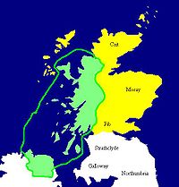
Islands of the Clyde
Encyclopedia
Scotland
Scotland is a country that is part of the United Kingdom. Occupying the northern third of the island of Great Britain, it shares a border with England to the south and is bounded by the North Sea to the east, the Atlantic Ocean to the north and west, and the North Channel and Irish Sea to the...
island groups after the Inner
Inner Hebrides
The Inner Hebrides is an archipelago off the west coast of Scotland, to the south east of the Outer Hebrides. Together these two island chains form the Hebrides, which enjoy a mild oceanic climate. There are 36 inhabited islands and a further 43 uninhabited Inner Hebrides with an area greater than...
and Outer Hebrides
Outer Hebrides
The Outer Hebrides also known as the Western Isles and the Long Island, is an island chain off the west coast of Scotland. The islands are geographically contiguous with Comhairle nan Eilean Siar, one of the 32 unitary council areas of Scotland...
, Orkney and Shetland. They are situated in the Firth of Clyde
Firth of Clyde
The Firth of Clyde forms a large area of coastal water, sheltered from the Atlantic Ocean by the Kintyre peninsula which encloses the outer firth in Argyll and Ayrshire, Scotland. The Kilbrannan Sound is a large arm of the Firth of Clyde, separating the Kintyre Peninsula from the Isle of Arran.At...
between Ayrshire
Ayrshire
Ayrshire is a registration county, and former administrative county in south-west Scotland, United Kingdom, located on the shores of the Firth of Clyde. Its principal towns include Ayr, Kilmarnock and Irvine. The town of Troon on the coast has hosted the British Open Golf Championship twice in the...
and Argyll
Argyll
Argyll , archaically Argyle , is a region of western Scotland corresponding with most of the part of ancient Dál Riata that was located on the island of Great Britain, and in a historical context can be used to mean the entire western coast between the Mull of Kintyre and Cape Wrath...
. There are about forty islands and skerries
Skerry
A skerry is a small rocky island, usually defined to be too small for habitation. It may simply be a rocky reef. A skerry can also be called a low sea stack....
, of which only six are inhabited and only nine larger than 40 hectares (98.8 acre). The largest and most populous are Arran
Isle of Arran
Arran or the Isle of Arran is the largest island in the Firth of Clyde, Scotland, and with an area of is the seventh largest Scottish island. It is in the unitary council area of North Ayrshire and the 2001 census had a resident population of 5,058...
and Bute
Isle of Bute
Bute is an island in the Firth of Clyde in Scotland. Formerly part of the county of Buteshire, it now constitutes part of the council area of Argyll and Bute. Its resident population was 7,228 in April 2001.-Geography:...
, and Great Cumbrae
Great Cumbrae
Great Cumbrae is the larger of the two islands known as The Cumbraes in the lower Firth of Clyde in western Scotland...
and Holy Isle
Holy Isle, Firth of Clyde
The Holy Isle, Firth of Clyde is one of a number of islands in the United Kingdom which go under the name "Holy Island". It is located in the Firth of Clyde off the west coast of central Scotland, inside Lamlash Bay on the larger island of Arran.- Details :The island is around long and around ...
are also served by dedicated ferry routes. Unlike the four larger Scottish archipelagos, none of the isles in this group are connected to one another or to the mainland by bridges.
The geology
Geology
Geology is the science comprising the study of solid Earth, the rocks of which it is composed, and the processes by which it evolves. Geology gives insight into the history of the Earth, as it provides the primary evidence for plate tectonics, the evolutionary history of life, and past climates...
and geomorphology
Geomorphology
Geomorphology is the scientific study of landforms and the processes that shape them...
of the area is complex and the islands and the surrounding sea loch
Loch
Loch is the Irish and Scottish Gaelic word for a lake or a sea inlet. It has been anglicised as lough, although this is pronounced the same way as loch. Some lochs could also be called a firth, fjord, estuary, strait or bay...
s each have distinctive features. The influence of the Atlantic Ocean
Atlantic Ocean
The Atlantic Ocean is the second-largest of the world's oceanic divisions. With a total area of about , it covers approximately 20% of the Earth's surface and about 26% of its water surface area...
and the North Atlantic Drift
North Atlantic Current
The North Atlantic Current is a powerful warm ocean current that continues the Gulf Stream northeast. West of Ireland it splits in two; one branch, the Canary Current, goes south, while the other continues north along the coast of northwestern Europe...
create a mild, damp oceanic climate.
The larger islands have been continuously inhabited since Neolithic
Neolithic
The Neolithic Age, Era, or Period, or New Stone Age, was a period in the development of human technology, beginning about 9500 BC in some parts of the Middle East, and later in other parts of the world. It is traditionally considered as the last part of the Stone Age...
times, were influenced by the emergence of the kingdom of Dál Riata
Dál Riata
Dál Riata was a Gaelic overkingdom on the western coast of Scotland with some territory on the northeast coast of Ireland...
from 500 AD and then absorbed into the emerging Kingdom of Alba
Origins of the Kingdom of Alba
The Origins of the Kingdom of Alba pertains to the origins of the Kingdom of Alba, or the Gaelic Kingdom of Scotland, either as a mythological event or a historical process, during the Early Middle Ages.-Medieval version:...
under Kenneth MacAlpin. They experienced Norse
Norsemen
Norsemen is used to refer to the group of people as a whole who spoke what is now called the Old Norse language belonging to the North Germanic branch of Indo-European languages, especially Norwegian, Icelandic, Faroese, Swedish and Danish in their earlier forms.The meaning of Norseman was "people...
incursions during the early Middle Ages
Middle Ages
The Middle Ages is a periodization of European history from the 5th century to the 15th century. The Middle Ages follows the fall of the Western Roman Empire in 476 and precedes the Early Modern Era. It is the middle period of a three-period division of Western history: Classic, Medieval and Modern...
and then became part of the Kingdom of Scotland
Kingdom of Scotland
The Kingdom of Scotland was a Sovereign state in North-West Europe that existed from 843 until 1707. It occupied the northern third of the island of Great Britain and shared a land border to the south with the Kingdom of England...
in the 13th century. There is a diversity of wildlife, including three species of rare endemic tree.
Geology and geography
Highland Boundary Fault
The Highland Boundary Fault is a geological fault that traverses Scotland from Arran and Helensburgh on the west coast to Stonehaven in the east...
runs past Bute and through the northern part of Arran, so from a geological perspective some of the islands are in the Highlands and some in the Central Lowlands
Central Lowlands
The Central Lowlands or Midland Valley is a geologically defined area of relatively low-lying land in southern Scotland. It consists of a rift valley between the Highland Boundary Fault to the north and the Southern Uplands Fault to the south...
. As a result, Arran is sometimes referred to as "Scotland in miniature" and the island is a popular destination for geologist
Geologist
A geologist is a scientist who studies the solid and liquid matter that constitutes the Earth as well as the processes and history that has shaped it. Geologists usually engage in studying geology. Geologists, studying more of an applied science than a theoretical one, must approach Geology using...
s, who come to see intrusive igneous landforms
Igneous rock
Igneous rock is one of the three main rock types, the others being sedimentary and metamorphic rock. Igneous rock is formed through the cooling and solidification of magma or lava...
such as sill
Sill (geology)
In geology, a sill is a tabular sheet intrusion that has intruded between older layers of sedimentary rock, beds of volcanic lava or tuff, or even along the direction of foliation in metamorphic rock. The term sill is synonymous with concordant intrusive sheet...
s and dyke
Dike (geology)
A dike or dyke in geology is a type of sheet intrusion referring to any geologic body that cuts discordantly across* planar wall rock structures, such as bedding or foliation...
s as well as sedimentary and metasedimentary rocks ranging widely in age. Visiting in 1787, the geologist James Hutton
James Hutton
James Hutton was a Scottish physician, geologist, naturalist, chemical manufacturer and experimental agriculturalist. He is considered the father of modern geology...
found his first example of an unconformity
Hutton's Unconformity
Hutton's Unconformity is any of various famous geological sites in Scotland. These are places identified by 18th-century Scottish geologist James Hutton as an unconformity, which provided evidence for his Plutonist theories of uniformitarianism and about the age of the Earth.-Theory of rock...
there and this spot is one of the most famous places in the study of geology. A group of weakly metamorphosed rocks that form the Highland Border Complex lie discontinuously along the Highland Boundary Fault. One of the most prominent exposures is along Loch Fad on Bute. Ailsa Craig
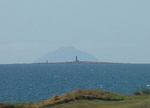
Ailsa Craig
Ailsa Craig is an island of 219.69 acres in the outer Firth of Clyde, Scotland where blue hone granite was quarried to make curling stones. "Ailsa" is pronounced "ale-sa", with the first syllable stressed...
, which lies some 25 kilometres (15.5 mi) south of Arran, has been quarried for a rare type of micro-granite
Granite
Granite is a common and widely occurring type of intrusive, felsic, igneous rock. Granite usually has a medium- to coarse-grained texture. Occasionally some individual crystals are larger than the groundmass, in which case the texture is known as porphyritic. A granitic rock with a porphyritic...
containing riebeckite
Riebeckite
Riebeckite is a sodium-rich member of the amphibole group of silicate minerals, chemical formula [][Na2][32][2|Si8O22]. It forms a series with magnesioriebeckite. It crystallizes in the monoclinic system, usually as long prismatic crystals showing a diamond-shaped cross section, but also in...
known as "Ailsite" which is used to make curling
Curling
Curling is a sport in which players slide stones across a sheet of ice towards a target area. It is related to bowls, boule and shuffleboard. Two teams, each of four players, take turns sliding heavy, polished granite stones, also called "rocks", across the ice curling sheet towards the house, a...
stones. As of 2004, 60 to 70% of all curling stones in use were made from granite from the island.
In common with the rest of Scotland the Firth of Clyde was covered by ice sheets during the Pleistocene
Pleistocene
The Pleistocene is the epoch from 2,588,000 to 11,700 years BP that spans the world's recent period of repeated glaciations. The name pleistocene is derived from the Greek and ....
ice ages and the landscape is much affected by glaciation. Arran's highest peaks may have been nunatak
Nunatak
A nunatak is an exposed, often rocky element of a ridge, mountain, or peak not covered with ice or snow within an ice field or glacier. The term is typically used in areas where a permanent ice sheet is present...
s at this time. After the last retreat of the ice sea level changes and the isostatic
Isostasy
Isostasy is a term used in geology to refer to the state of gravitational equilibrium between the earth's lithosphere and asthenosphere such that the tectonic plates "float" at an elevation which depends on their thickness and density. This concept is invoked to explain how different topographic...
rise of land makes charting post glacial
Quaternary glaciation
Quaternary glaciation, also known as the Pleistocene glaciation, the current ice age or simply the ice age, refers to the period of the last few million years in which permanent ice sheets were established in Antarctica and perhaps Greenland, and fluctuating ice sheets have occurred elsewhere...
coastlines a complex task but the resultant clifflines behind raised beach
Raised beach
A raised beach, marine terrace, or perched coastline is an emergent coastal landform. Raised beaches and marine terraces are beaches or wave-cut platforms raised above the shore line by a relative fall in the sea level ....
es are a prominent feature of the entire coastline.
The soils of the islands reflect the diverse geology. Bute has the most productive land, and a pattern of deposits that is typical of the southwest of Scotland. There is a mixture of boulder clay
Boulder clay
Boulder clay, in geology, is a deposit of clay, often full of boulders, which is formed in and beneath glaciers and ice-sheets wherever they are found, but is in a special sense the typical deposit of the Glacial Period in northern Europe and North America...
and other glacial deposits in the eroded valleys, and raised beach and marine deposits elsewhere, especially to the south and west which result in a machair landscape in places, inland from the sandy bays, such as Stravanan.
The Firth of Clyde, in which these island lie, is north of the Irish Sea and has numerous branching inlets, some of them substantial features in their own right. These include Loch Goil
Loch Goil
Loch Goil is a small sea loch in Scotland.It is an arm of Loch Long. The village of Lochgoilhead stands at its head.Located in the Loch Lomond & Trossachs National Park, Lochgoilhead sits at the head of Loch Goil, a fjord type sea loch. Only an hour from the Erskine Bridge, Glasgow Airport the M8...
, Loch Long
Loch Long
Loch Long is a body of water in Argyll and Bute, Scotland. The sea loch extends from the Firth of Clyde at its southwestern end. It measures approximately 20 miles in length, with a width of between one and two miles...
, Gare Loch
Gare Loch
The Gare Loch or Gareloch is a sea loch in Argyll and Bute, Scotland.-Geography:A sea loch aligned north-south, Gare Loch is 10 kilometres long with an average width of 1.5 kilometres. At its southern end it opens into the Firth of Clyde through the Rhu narrows...
, Loch Fyne
Loch Fyne
Loch Fyne is a sea loch on the west coast of Argyll and Bute, Scotland. It extends inland from the Sound of Bute, making it the longest of the sea lochs...
and the estuary of the River Clyde
River Clyde
The River Clyde is a major river in Scotland. It is the ninth longest river in the United Kingdom, and the third longest in Scotland. Flowing through the major city of Glasgow, it was an important river for shipbuilding and trade in the British Empire....
. In places the effect of glaciation on the seabed is pronounced. For example, the Firth is 320 metres (1,049.9 ft) deep between Arran and Bute, although they are only 8 kilometres (5 mi) apart. The islands are all exposed to wind and tide and various lighthouse
Lighthouse
A lighthouse is a tower, building, or other type of structure designed to emit light from a system of lamps and lenses or, in older times, from a fire, and used as an aid to navigation for maritime pilots at sea or on inland waterways....
s, such as those on Ailsa Craig, Pladda
Pladda
Pladda is an island off the west coast of Scotland. It is home to a lighthouse of the same name.-Geography:Pladda lies off the south coast of Arran in the Firth of Clyde at ....
and Davaar
Davaar Island
Davaar Island or Island Davaar is located at the mouth of Campbeltown Loch off the east coast of Kintyre, in Argyll and Bute, Scotland. It is a tidal island, linked to the mainland by a natural shingle causeway called the Dhorlin near Campbeltown at low tide...
act as an aid to navigation.
Climate
Labrador
Labrador is the distinct, northerly region of the Canadian province of Newfoundland and Labrador. It comprises the mainland portion of the province, separated from the island of Newfoundland by the Strait of Belle Isle...
in Canada and north of the Aleutian Islands, but the influence of the North Atlantic Drift
North Atlantic Current
The North Atlantic Current is a powerful warm ocean current that continues the Gulf Stream northeast. West of Ireland it splits in two; one branch, the Canary Current, goes south, while the other continues north along the coast of northwestern Europe...
—the northern extension of the Gulf Stream
Gulf Stream
The Gulf Stream, together with its northern extension towards Europe, the North Atlantic Drift, is a powerful, warm, and swift Atlantic ocean current that originates at the tip of Florida, and follows the eastern coastlines of the United States and Newfoundland before crossing the Atlantic Ocean...
—ameliorates the winter weather and the area enjoys a mild, damp oceanic climate. Temperatures are generally cool, averaging about 6 °C (42.8 °F) in January and 14 °C (57.2 °F) in July at sea level. Snow seldom lies at sea level and frosts are generally less frequent than the mainland. In common with most islands of the west coast of Scotland, rainfall is generally high at between 1300 mm (51.2 in) per annum on Bute, the Cumbraes and in the south of Arran and 1900 mm (74.8 in) per annum in the north of Arran. The Arran mountains are wetter still with the summits receiving over 2550 mm (100.4 in) annually. May, June and July are the sunniest months, with upwards of 200 hours of bright sunshine being recorded on average, southern Bute benefiting from a particularly high level of sunny days.
Prehistory
Mesolithic
The Mesolithic is an archaeological concept used to refer to certain groups of archaeological cultures defined as falling between the Paleolithic and the Neolithic....
humans arrived in the Firth of the Clyde during the fourth millennium BC, probably from Ireland
Ireland
Ireland is an island to the northwest of continental Europe. It is the third-largest island in Europe and the twentieth-largest island on Earth...
. This was followed by a wave of Neolithic
Neolithic
The Neolithic Age, Era, or Period, or New Stone Age, was a period in the development of human technology, beginning about 9500 BC in some parts of the Middle East, and later in other parts of the world. It is traditionally considered as the last part of the Stone Age...
peoples using the same route and there is some evidence that the Firth of Clyde was a significant route via which mainland Scotland was colonised at this time. A particular style of megalithic structure developed in Argyll, the Clyde estuary and elsewhere in western Scotland that has become known as the Clyde cairn. They are rectangular or trapezoidal in shape with a small enclosing chamber faced with large slabs of stone set on end and sometimes subdivided into smaller compartments. A forecourt area may have been used for displays or rituals associated with the internment of the dead, who were placed inside the chambers. They are concentrated in Arran, Bute and Kintyre and it is likely that the Clyde cairns were the earliest forms of Neolithic monument constructed by incoming settlers although few of the 100 or so examples have been given a radiocarbon dating
Radiocarbon dating
Radiocarbon dating is a radiometric dating method that uses the naturally occurring radioisotope carbon-14 to estimate the age of carbon-bearing materials up to about 58,000 to 62,000 years. Raw, i.e. uncalibrated, radiocarbon ages are usually reported in radiocarbon years "Before Present" ,...
. An example at Monamore on Arran has been dated to 3160 BC, although it was almost certainly built earlier than that, possibly c. 4000BC. There are also numerous standing stone
Standing stone
Standing stones, orthostats, liths, or more commonly megaliths are solitary stones set vertically in the ground and come in many different varieties....
s dating from prehistoric times, including six stone circle
Stone circle
A stone circle is a monument of standing stones arranged in a circle. Such monuments have been constructed across the world throughout history for many different reasons....
s on Machrie Moor, Arran and other examples on Great Cumbrae and Bute.
Bronze Age
Bronze Age
The Bronze Age is a period characterized by the use of copper and its alloy bronze as the chief hard materials in the manufacture of some implements and weapons. Chronologically, it stands between the Stone Age and Iron Age...
settlers also constructed megaliths at various sites, many of them dating from the second millennium BC, although the chambered cairns were replaced by burial cist
Cist
A cist from ) is a small stone-built coffin-like box or ossuary used to hold the bodies of the dead. Examples can be found across Europe and in the Middle East....
s, found on for example, Inchmarnock. Settlement evidence, especially from the early part of this era is however poor. The Queen of the Inch necklace is an article of jewellery made of jet
Jet (lignite)
Jet is a geological material and is considered to be a minor gemstone. Jet is not considered a true mineral, but rather a mineraloid as it has an organic origin, being derived from decaying wood under extreme pressure....
found on Bute that dates from circa 2000 BC. During the early Iron Age
Iron Age
The Iron Age is the archaeological period generally occurring after the Bronze Age, marked by the prevalent use of iron. The early period of the age is characterized by the widespread use of iron or steel. The adoption of such material coincided with other changes in society, including differing...
Brython
Brython
The Britons were the Celtic people culturally dominating Great Britain from the Iron Age through the Early Middle Ages. They spoke the Insular Celtic language known as British or Brythonic...
ic culture held sway, there being no evidence that the Roman
Roman Empire
The Roman Empire was the post-Republican period of the ancient Roman civilization, characterised by an autocratic form of government and large territorial holdings in Europe and around the Mediterranean....
occupation of southern Scotland extended to these islands.
Early Scots rule
Dál Riata
Dál Riata was a Gaelic overkingdom on the western coast of Scotland with some territory on the northeast coast of Ireland...
was established. Unlike the P-Celtic speaking Brythons, these Gaels spoke a form of Gaelic
Scottish Gaelic language
Scottish Gaelic is a Celtic language native to Scotland. A member of the Goidelic branch of the Celtic languages, Scottish Gaelic, like Modern Irish and Manx, developed out of Middle Irish, and thus descends ultimately from Primitive Irish....
that still survives in the Hebrides
Hebrides
The Hebrides comprise a widespread and diverse archipelago off the west coast of Scotland. There are two main groups: the Inner and Outer Hebrides. These islands have a long history of occupation dating back to the Mesolithic and the culture of the residents has been affected by the successive...
. Through the efforts of Saint Ninian
Saint Ninian
Saint Ninian is a Christian saint first mentioned in the 8th century as being an early missionary among the Pictish peoples of what is now Scotland...
and others Christianity slowly supplanted Druid
Druid
A druid was a member of the priestly class in Britain, Ireland, and Gaul, and possibly other parts of Celtic western Europe, during the Iron Age....
ism. Dál Riata flourished from the time of Fergus Mór
Fergus Mór
Fergus Mór mac Eirc was a legendary king of Dál Riata. He was the son of Erc.While his historicity may be debatable, his posthumous importance as the founder of Scotland in the national myth of Medieval and Renaissance Scotland is not in doubt...
in the late fifth century until the Viking
Viking
The term Viking is customarily used to refer to the Norse explorers, warriors, merchants, and pirates who raided, traded, explored and settled in wide areas of Europe, Asia and the North Atlantic islands from the late 8th to the mid-11th century.These Norsemen used their famed longships to...
incursions that commenced in the late eighth century. Islands close to the shores of modern Ayrshire
Ayrshire
Ayrshire is a registration county, and former administrative county in south-west Scotland, United Kingdom, located on the shores of the Firth of Clyde. Its principal towns include Ayr, Kilmarnock and Irvine. The town of Troon on the coast has hosted the British Open Golf Championship twice in the...
would have remained part of the Kingdom of Strathclyde
Kingdom of Strathclyde
Strathclyde , originally Brythonic Ystrad Clud, was one of the early medieval kingdoms of the celtic people called the Britons in the Hen Ogledd, the Brythonic-speaking parts of what is now southern Scotland and northern England. The kingdom developed during the post-Roman period...
during this period, whilst the main islands became part of the emerging Kingdom of Alba
Kingdom of Alba
The name Kingdom of Alba pertains to the Kingdom of Scotland between the deaths of Donald II in 900, and of Alexander III in 1286 which then led indirectly to the Scottish Wars of Independence...
founded by Kenneth MacAlpin (Cináed mac Ailpín).
Viking influence
The Islands of the Clyde historically formed the border zone between the Norse-dominated Sudreyor and Scotland. As such many of these islands fell under Norwegian and Ui ImairUí Ímair
The Uí Ímair , or Dynasty of Ivar, were an enormous royal and imperial Norse dynasty who ruled Northern England, the Irish Sea region and Kingdom of Dublin, and the western coast of Scotland, including the Hebrides, from the mid 9th century, losing control of the first in the mid 10th, but the rest...
hegemony between the 9th and 13th centuries and this Norse influence would see almost constant warfare on the western seaboard of Scotland until the partitioning of the Hebrides in 1156.
Outer Hebrides
The Outer Hebrides also known as the Western Isles and the Long Island, is an island chain off the west coast of Scotland. The islands are geographically contiguous with Comhairle nan Eilean Siar, one of the 32 unitary council areas of Scotland...
remained under the control of Godred V of the Isle of Man while the Inner Hebrides
Inner Hebrides
The Inner Hebrides is an archipelago off the west coast of Scotland, to the south east of the Outer Hebrides. Together these two island chains form the Hebrides, which enjoy a mild oceanic climate. There are 36 inhabited islands and a further 43 uninhabited Inner Hebrides with an area greater than...
south of Ardnamurchan and the islands of the Clyde became part of the Kingdom of the Hebrides controlled by Somerled
Somerled
Somerled was a military and political leader of the Scottish Isles in the 12th century who was known in Gaelic as rí Innse Gall . His father was Gillebride...
. This began a process whereby the islands of the Clyde became Scottish in language and culture rather than Norse. After Somerled's death in 1164 his kingdom was split between his three sons, Ragnall
Raghnall mac Somhairle
Ragnall mac Somairle, or Ragnall son of Somairle, was a late 12th century and possibly early 13th century magnate, seated on the western seaboard of Scotland. He was likely a younger son of Somairle mac Gilla Brigte, Lord of Argyll and his wife, Ragnhildr, daughter of Óláfr Guðrøðarson, King of...
in Islay and Kintyre, Dughall
Dubgall mac Somairle
Dubgall mac Somairle was a 12th century Scottish nobleman...
in Lorne and the other Argyll islands, and Angus
Áonghas mac Somhairle
Aonghas mac Somhairle was a son of Somerled and Ragnhild, . Aonghas succeeded his father, inheriting lands in Garmoran, Skye, Rum, Eigg, Bute and Arran and became known as Lord of Bute and Arran...
holding Arran and Bute.
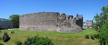
Nearly a century later in the 1230s invading Norse forces took Rothesay Castle
Rothesay Castle
Rothesay Castle is a ruined castle in Rothesay, the principal town on the Isle of Bute, in western Scotland. Located at , the castle has been described as "one of the most remarkable in Scotland", for its long history dating back to the beginning of the 13th century, and its unusual circular...
, hacking through the walls with their axes. In 1263 troops commanded by Haakon Haakonarson
Haakon IV of Norway
Haakon Haakonarson , also called Haakon the Old, was king of Norway from 1217 to 1263. Under his rule, medieval Norway reached its peak....
repeated the feat but the ensuing Battle of Largs
Battle of Largs
The Battle of Largs was an engagement fought between the armies of Norway and Scotland near the present-day town of Largs in North Ayrshire on the Firth of Clyde in Scotland on 2 October 1263. It was the most important military engagement of the Scottish-Norwegian War. The Norwegian forces were...
between Scots and Norse forces, which took place on the shores of the Firth of Clyde, was inconclusive as a military contest. This marked an ultimately terminal weakening of Norse power in Scotland. Haakon retreated to Orkney, where he died in December 1263, entertained on his death bed by recitations of the sagas. Following this ill-fated expedition, all rights that the Norwegian crown "had of old therein" in relation to the islands were yielded to the Kingdom of Scotland as a result of the 1266 Treaty of Perth
Treaty of Perth
The Treaty of Perth, 1266, ended military conflict between Norway, under King Magnus VI of Norway, and Scotland, under King Alexander III, over the sovereignty of the Hebrides and the Isle of Man....
.
Modern Scotland
From the mid thirteenth century to the present day all of the islands of the Clyde have remained part of Scotland.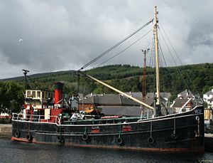
Bishop of Sodor and Man
The Bishop of Sodor and Man is the Ordinary of the Diocese of Sodor and Man in the Province of York in the Church of England. The diocese covers the Isle of Man. The see is in the town of Peel where the bishop's seat is located at the Cathedral Church of St German, elevated to cathedral status on 1...
, based at Peel, on the Isle of Man
Isle of Man
The Isle of Man , otherwise known simply as Mann , is a self-governing British Crown Dependency, located in the Irish Sea between the islands of Great Britain and Ireland, within the British Isles. The head of state is Queen Elizabeth II, who holds the title of Lord of Mann. The Lord of Mann is...
. Thereafter, the seat of the Bishopric of the Isles
Diocese of the Isles
The Diocese of the Isles or Sodor was one of the thirteen dioceses of medieval Scotland. The original seat of the bishopric appears to have been at Peel, on St Patrick's Isle, where indeed it continued to be under English overlordship; the Bishopric of the Isles as it was after the split was...
was relocated to the north, firstly to Snizort
Snizort
Snizort is an area of the Isle of Skye comprising the head of Loch Snizort and the western coast of Trotternish up to Uig, which is the largest settlement....
on Skye
Skye
Skye or the Isle of Skye is the largest and most northerly island in the Inner Hebrides of Scotland. The island's peninsulas radiate out from a mountainous centre dominated by the Cuillin hills...
and then Iona
Iona
Iona is a small island in the Inner Hebrides off the western coast of Scotland. It was a centre of Irish monasticism for four centuries and is today renowned for its tranquility and natural beauty. It is a popular tourist destination and a place for retreats...
, a state of affairs which continued until the 16th century Scottish Reformation
Scottish Reformation
The Scottish Reformation was Scotland's formal break with the Papacy in 1560, and the events surrounding this. It was part of the wider European Protestant Reformation; and in Scotland's case culminated ecclesiastically in the re-establishment of the church along Reformed lines, and politically in...
.
The century following 1750 was time of significant change. New forms of transport, industry and agriculture brought sweeping changes, and an end to traditional ways of life that had endured for centuries. The aftermath of the Battle of Culloden
Battle of Culloden
The Battle of Culloden was the final confrontation of the 1745 Jacobite Rising. Taking place on 16 April 1746, the battle pitted the Jacobite forces of Charles Edward Stuart against an army commanded by William Augustus, Duke of Cumberland, loyal to the British government...
marked the beginning of the end for the clan
Scottish clan
Scottish clans , give a sense of identity and shared descent to people in Scotland and to their relations throughout the world, with a formal structure of Clan Chiefs recognised by the court of the Lord Lyon, King of Arms which acts as an authority concerning matters of heraldry and Coat of Arms...
system and whilst there were marked improvements in living standards for some, these transformations came at a cost for others. In the early 19th century Alexander, 10th Duke of Hamilton (1767–1852) embarked on a programme of clearances
Highland Clearances
The Highland Clearances were forced displacements of the population of the Scottish Highlands during the 18th and 19th centuries. They led to mass emigration to the sea coast, the Scottish Lowlands, and the North American colonies...
that had a devastating effect on Arran's population. Whole villages were removed and the Gaelic culture of the island dealt a terminal blow. A memorial to this early form of ethnic cleansing
Ethnic cleansing
Ethnic cleansing is a purposeful policy designed by one ethnic or religious group to remove by violent and terror-inspiring means the civilian population of another ethnic orreligious group from certain geographic areas....
has been constructed on the shore at Lamlash
Lamlash
Lamlash is the largest village by population on the Isle of Arran, in the Firth of Clyde, Scotland. It lies 4 miles to the south of ferry port Brodick, in a sheltered bay on the island's east coast, facing Holy Isle. Lamlash is the seat of Arran's local government offices and police...
, paid for by a Canadian descendant of the emigrants.
From the 1850s to the late 20th century the Clyde Puffer
Clyde puffer
The Clyde puffer is essentially a type of small steamboat which provided a vital supply link around the west coast and Hebrides islands of Scotland, stumpy little cargo ships that have achieved almost mythical status thanks largely to the short stories Neil Munro wrote about the Vital Spark and her...
, made famous by the Vital Spark
Vital Spark
The Vital Spark is a fictional Clyde puffer, created by Scottish writer Neil Munro. As its captain, the redoubtable Para Handy, often says: "the smertest boat in the coastin' tred"....
, was the workhorse of the islands, carrying all kinds of produce and products to and from the islands. The Caledonian Steam Packet Company
Caledonian Steam Packet Company
The Caledonian Steam Packet Company provided a scheduled shipping service, carrying freight and passengers, on the west coast of Scotland. Formed in 1889 to complement the services of the Caledonian Railway, the company expanded by taking over rival ferry companies...
was formed in May 1889 to operate steamer services to and from Gourock for the Caledonian Railway
Caledonian Railway
The Caledonian Railway was a major Scottish railway company. It was formed in the early 19th century and it was absorbed almost a century later into the London, Midland and Scottish Railway, in the 1923 railway grouping, by means of the Railways Act 1921...
and soon expanded by taking over rival steamer operators. David MacBrayne Ltd
David MacBrayne Ltd
David MacBrayne Ltd is a company owned by the Scottish Government. Formed in 1851 as a private shipping company, it became the main carrier for freight and passengers in the Hebrides...
operated the Glasgow to Ardrishaig
Ardrishaig
Ardrishaig is a lochside village at the southern entrance to the Crinan Canal in west Scotland, in Argyll. Ardrishaig had 1,283 inhabitants in 2001....
steamer service, as part of the "Royal Route" to Oban. During the 20th century many of the islands were developed as tourist resorts for Glaswegians who went "Doon the Watter", in parallel to mainland resorts such as Largs
Largs
Largs is a town on the Firth of Clyde in North Ayrshire, Scotland, about from Glasgow. The original name means "the slopes" in Scottish Gaelic....
and Troon
Troon
Troon is a town in South Ayrshire. It is situated on the west coast of Scotland, about eight miles north of Ayr and three miles northwest of Glasgow Prestwick International Airport. Lying across the Firth of Clyde, the Isle of Arran can be seen. Troon is also a port with freight and ferry services...
.
In 1973 CSP and MacBraynes commenced joint Clyde and West Highland operations under the new name of Caledonian MacBrayne
Caledonian MacBrayne
Caledonian MacBrayne is the major operator of passenger and vehicle ferries, and ferry services, between the mainland of Scotland and 22 of the major islands on Scotland's west coast...
. A publicly owned
Government-owned corporation
A government-owned corporation, state-owned company, state-owned entity, state enterprise, publicly owned corporation, government business enterprise, or parastatal is a legal entity created by a government to undertake commercial activities on behalf of an owner government...
company, they serve Great Cumbrae, Arran and Bute as well as running mainland-to-mainland ferrys across the firth. Private companies operate services from Arran to Holy Isle and from McInroy's Point (Gourock) to Hunter's Quay on the Cowal peninsula.
The majority of the islands at one time made up the traditional county of Bute
County of Bute
The County of Bute is one of the registration counties of Scotland. In 2001 its usually resident population was 13,720.-Local government county:...
. Today the islands are split more or less equally between the modern unitary authorities of Argyll and Bute
Argyll and Bute
Argyll and Bute is both one of 32 unitary council areas; and a Lieutenancy area in Scotland. The administrative centre for the council area is located in Lochgilphead.Argyll and Bute covers the second largest administrative area of any Scottish council...
and North Ayrshire
North Ayrshire
North Ayrshire is one of 32 council areas in Scotland with a population of roughly 136,000 people. It is located in the south-west region of Scotland, and borders the areas of Inverclyde to the north, Renfrewshire to the north-east and East Ayrshire and South Ayrshire to the East and South...
with only Ailsa Craig and Lady Isle
Lady Isle
Lady Isle is a small, uninhabited island, in the Firth of Clyde, Scotland. It was once home to a chapel dedicated to Saint Mary. The island features an interesting lighthouse and a freshwater spring.-Geography:...
in South Ayrshire
South Ayrshire
South Ayrshire is one of 32 council areas of Scotland, covering the southern part of Ayrshire. It borders onto East Ayrshire, North Ayrshire and Dumfries and Galloway....
falling outwith these two council areas
Subdivisions of Scotland
For local government purposes, Scotland is divided into 32 areas designated as "council areas" which are all governed by unitary authorities designated as "councils"...
.
Islands
The following table gives a list of the islands of the Firth of Clyde with an area greater than 40 hectares (approximately 100 acres) plus adjacent smaller uninhabited islets, tidal islets only separated at higher stages of the tide, and skerriesSkerry
A skerry is a small rocky island, usually defined to be too small for habitation. It may simply be a rocky reef. A skerry can also be called a low sea stack....
which are only exposed at lower stages of the tide.
| Island | Gaelic Name | Location | Area (ha Hectare The hectare is a metric unit of area defined as 10,000 square metres , and primarily used in the measurement of land. In 1795, when the metric system was introduced, the are was defined as being 100 square metres and the hectare was thus 100 ares or 1/100 km2... ) |
Population | Last inhabited | Highest point | Surrounding islets | |
|---|---|---|---|---|---|---|---|---|
| Ailsa Craig Ailsa Craig Ailsa Craig is an island of 219.69 acres in the outer Firth of Clyde, Scotland where blue hone granite was quarried to make curling stones. "Ailsa" is pronounced "ale-sa", with the first syllable stressed... |
Creag Ealasaid | South Ayrshire South Ayrshire South Ayrshire is one of 32 council areas of Scotland, covering the southern part of Ayrshire. It borders onto East Ayrshire, North Ayrshire and Dumfries and Galloway.... |
99 | 0 | 1980s | The Cairn | 338 | None |
| Arran Isle of Arran Arran or the Isle of Arran is the largest island in the Firth of Clyde, Scotland, and with an area of is the seventh largest Scottish island. It is in the unitary council area of North Ayrshire and the 2001 census had a resident population of 5,058... |
Eilean Arainn | Arran | 43201 | 5058 | – | Goat Fell Goat Fell Goat Fell is the highest point on the Isle of Arran. At 874 metres , it is one of four Corbetts on the island... |
874 | Eilean na h-Àirde Bàine, Hamilton Isle, Pladda Pladda Pladda is an island off the west coast of Scotland. It is home to a lighthouse of the same name.-Geography:Pladda lies off the south coast of Arran in the Firth of Clyde at .... |
| Bute Isle of Bute Bute is an island in the Firth of Clyde in Scotland. Formerly part of the county of Buteshire, it now constitutes part of the council area of Argyll and Bute. Its resident population was 7,228 in April 2001.-Geography:... |
Eilean Bòid | Bute | 12217 | 7228 | – | Windy Hill | 278 | The Burnt Islands Burnt Islands The Burnt Islands is the collective title for three small islands that lie in the Kyles of Bute off the west coast of the Scottish mainland. The islands are located at .... : Eilean Mòr, Eilean Fraoich and Eilean Buidhe, Eilean Dearg Eilean Dearg, Loch Riddon Eilean Dearg is a small island in Loch Riddon. The island was once home to a castle, which was destroyed by naval action in Argyll's Rising in 1685. No visible remains of the castle are to be found, but archaeologists excavated the site between 1964 and 1967, finding the castle's hall, chapel, a... , Eilean Dubh Eilean Dubh, Kyles of Bute ----This particular Eilean Dubh is sometimes known as Glen Caladh Island and is situated just off the Cowal peninsula in the Kyles of Bute. The island is around 0.3 kilometres along its longest length and rises to a height of 19 metres above sea level... , Sgat Beag and Sgat Mòr Sgat Mór and Sgat Beag Sgat Mòr and Sgat Beag are two small islands that lie off the Cowal peninsula on the west coast of Scotland.Sgat Mòr lies at at the mouth of Loch Fyne. The island rises just above sea level and is home to a small lighthouse. The area to the south of the island is the deepest area of water in... |
| Davaar Davaar Island Davaar Island or Island Davaar is located at the mouth of Campbeltown Loch off the east coast of Kintyre, in Argyll and Bute, Scotland. It is a tidal island, linked to the mainland by a natural shingle causeway called the Dhorlin near Campbeltown at low tide... |
Eilean Dà Bhàrr | Kintyre | 52 | 2 | – | 115 | None | |
| Great Cumbrae Great Cumbrae Great Cumbrae is the larger of the two islands known as The Cumbraes in the lower Firth of Clyde in western Scotland... |
Cumaradh Mòr | Bute | 1168 | 1434 | – | The Glaidstane | 127 | The Clach, The Eileans The Eileans The Eileans are two small, low lying islands located in Newtown Bay, Millport on the Isle of Cumbrae, Scotland .The name is an anglicisation of the Scottish Gaelic, eilean meaning "Island"... , The Leug, The Spoig |
| Holy Isle Holy Isle, Firth of Clyde The Holy Isle, Firth of Clyde is one of a number of islands in the United Kingdom which go under the name "Holy Island". It is located in the Firth of Clyde off the west coast of central Scotland, inside Lamlash Bay on the larger island of Arran.- Details :The island is around long and around ... |
Eilean Mo Laise | Arran | 253 | 13 | – | Mullach Mòr | 314 | None |
| Inchmarnock Inchmarnock Inchmarnock is an island at the northern end of the Sound of Bute on the west coast of Scotland.-Geography:Inchmarnock lies to the west of the Isle of Bute at the northern end of the Sound of Bute. It is around long and rises to a height of . The island consists mainly of a single ridge running... |
Innis Mheàrnaig | Bute | 253 | 0 | 1980s | 60 | None | |
| Little Cumbrae Little Cumbrae Little Cumbrae is an island in the Firth of Clyde, in North Ayrshire, Scotland. The island is known locally as Wee Cumbrae.-Etymology:... |
Cumaradh Beag | Bute | 313 | 0 | 1990s | Lighthouse Hill | 123 | The Broad Islands, Castle Island Castle Island, Scotland Castle Island or Allimturrail is a small tidal island, lying off the east coast of Little Cumbrae, and to the west of Trail Island, in the Firth of Clyde. It is joined to Little Cumbrae at low tide.... , Trail Isle |
| Sanda | Àbhainn | Kintyre Kintyre Kintyre is a peninsula in western Scotland, in the southwest of Argyll and Bute. The region stretches approximately 30 miles , from the Mull of Kintyre in the south, to East Loch Tarbert in the north... |
127 | 1 | – | 123 | Glunimore Island Glunimore Island Glunimore Island is an uninhabited island around south east of the Kintyre peninsula, Scotland. It lies alongside Sanda Island and Sheep Island... , Henrietta Reef, Scart Rocks, Paterson's Rock, Sheep Island Sheep Island, Argyll and Bute Sheep Island is a small island situated off the southern tip of the Kintyre peninsula in Scotland.Sheep Island, along with Sanda Island and Glunimore Island, form a small group of islands approximately south of Kintyre at .... |
Outlying islands
Gare Loch is a small loch which hosts the Faslane Naval Base, the home of the UK's Trident nuclear submarines
Vanguard class submarine
The Vanguard class are the Royal Navy's current nuclear ballistic missile submarines , each armed with up to 16 Trident II Submarine-launched ballistic missiles...
. At its southern end, the loch opens into the Firth of Clyde
Firth of Clyde
The Firth of Clyde forms a large area of coastal water, sheltered from the Atlantic Ocean by the Kintyre peninsula which encloses the outer firth in Argyll and Ayrshire, Scotland. The Kilbrannan Sound is a large arm of the Firth of Clyde, separating the Kintyre Peninsula from the Isle of Arran.At...
, via the Rhu
Rhu
Rhu is a village and historic parish on the east shore of the Gare Loch in Argyll and Bute, Scotland.The traditional spelling of its name was Row, but it was changed in the 1920s so that outsiders would pronounce it correctly...
narrows. It contains two islets: Green Island and Perch Rock.
The Kilbrannan Sound
Kilbrannan Sound
Kilbrannan Sound is a marine water body that separates the Kintyre Peninsula of Scotland from the island of Arran. Kilbrannan Sound is the western arm of the Firth of Clyde.-References:...
, which lies between Arran and the Kintyre
Kintyre
Kintyre is a peninsula in western Scotland, in the southwest of Argyll and Bute. The region stretches approximately 30 miles , from the Mull of Kintyre in the south, to East Loch Tarbert in the north...
peninsula, contains several islets: An Struthlag, Cour Island, Eilean Carrach (Carradale
Carradale
Carradale is a picturesque village on the east side of Kintyre, overlooking the Kilbrannan Sound and the west coast of the Isle of Arran, approximately 14 miles from Campbeltown...
), Eilean Carrach (Skipness
Skipness
Skipness is a village on the east coast of Kintyre in Scotland, a few miles south of Tarbert and facing the Isle of Arran.There is a ruined castle and Kilbrannan Chapel, which contains some rare grave slabs. There is a nearby cafe that serves fresh fish from the area, and beer brewed on Arran,...
), Eilean Grianain, Eilean Sunadale, Gull Isle, Island Ross and Thorn Isle. In the late 11th century Magnus Barefoot
Magnus III of Norway
Magnus Barefoot or Magnus III Olafsson was King of Norway from 1093 until 1103 and King of Mann and the Isles from 1099 until 1103.-Background:...
, King of Norway, made an arrangement with King Malcolm III of Scotland
Malcolm III of Scotland
Máel Coluim mac Donnchada , was King of Scots...
that he could take possession of land on the west coast around which a ship could sail. He had his longship
Longship
Longships were sea vessels made and used by the Vikings from the Nordic countries for trade, commerce, exploration, and warfare during the Viking Age. The longship’s design evolved over many years, beginning in the Stone Age with the invention of the umiak and continuing up to the 9th century with...
dragged across the 1.5 kilometre (0.93205910497471 mi) long isthmus in the north of Kintyre between East Loch Tarbert
East Loch Tarbert, Argyll
East Loch Tarbert, Argyll is a small sea loch on the eastern side of the Kintyre peninsula in Scotland. It is a part of the much larger Loch Fyne...
and West Loch Tarbert
West Loch Tarbert, Argyll
West Loch Tarbert, Argyll is a long and narrow sea loch on the western side of the Kintyre peninsula in Scotland.-Geography:The head of the loch lies near the village of Tarbert and it reaches the open sea at Ardpatrick Point some distant....
as part of a campaign to increase his possessions. Magnus declared that Kintyre had "better land than the best of the Hebrides
Hebrides
The Hebrides comprise a widespread and diverse archipelago off the west coast of Scotland. There are two main groups: the Inner and Outer Hebrides. These islands have a long history of occupation dating back to the Mesolithic and the culture of the residents has been affected by the successive...
", and by taking command of his ship's tiller and "sailing" across the isthmus he was able to claim the entire peninsula was an island, which remained under Norse rule for more than a dozen years as a result.
Loch Fyne, which extends 65 kilometres (40.4 mi) inland from the Sound of Bute
Sound of Bute
The Sound of Bute is a broad channel or sound separating the islands of Arran and Bute on the west coast of Scotland.The sound leads up from the lower Firth of Clyde passes the island of Inchmarnock and splits into the Kyles of Bute, Loch Fyne and round the north end of Arran into the Kilbrannan...
is the longest of Scotland's sea lochs and contains several islets and skerries. These are Duncuan Island, Eilean Ardgaddan, Eilean a' Bhuic, Eilean Aoghainn, Eilean a' Chomhraig, Eilean an Dúnain, Eilean Buidhe (Ardmarnock), Eilean Buidhe (Portavadie
Portavadie
Portavadie is a village in Argyll and Bute, Scotland.The Portavadie complex was built with the help of local labour from the fishing village 'Tarbert' that lay due west across Loch Fyne. The locals from Tarbert who worked there were told that oil had been found on the west shores Loch...
), Eilean Fraoch, Eilean Math-ghamhna, Eilean Mór, Glas Eilean, Heather Island, Inverneil Island, Kilbride Island and Liath Eilean.
The North Ayrshire
North Ayrshire
North Ayrshire is one of 32 council areas in Scotland with a population of roughly 136,000 people. It is located in the south-west region of Scotland, and borders the areas of Inverclyde to the north, Renfrewshire to the north-east and East Ayrshire and South Ayrshire to the East and South...
islets of Broad Rock, East Islet, Halftide Rock, High Rock and North Islet are all found surrounding Horse Isle
Horse Isle
Horse Isle is an uninhabited island located in the Firth of Clyde, Scotland near the seaside town of Ardrossan. It is a nature reserve, run by the RSPB.-Geography:...
. Lady Isle, which lies off the South Ayrshire coast near Troon
Troon
Troon is a town in South Ayrshire. It is situated on the west coast of Scotland, about eight miles north of Ayr and three miles northwest of Glasgow Prestwick International Airport. Lying across the Firth of Clyde, the Isle of Arran can be seen. Troon is also a port with freight and ferry services...
once housed "ane old chapell with an excellent spring of water". However, in June 1821 someone set fire to the "turf and pasture", and permanently destroyed the island's grazing, with gales blowing much of the island's soil into the sea.
Neither Loch Goil nor Loch Long, which are fjord
Fjord
Geologically, a fjord is a long, narrow inlet with steep sides or cliffs, created in a valley carved by glacial activity.-Formation:A fjord is formed when a glacier cuts a U-shaped valley by abrasion of the surrounding bedrock. Glacial melting is accompanied by rebound of Earth's crust as the ice...
-like arms of the firth to the north, contain islands.
Non-islands
The following are places along that shores of the Firth of Clyde that are not islands and have misleading names, eilean being Gaelic for "island": Eilean na Beithe, Portavadie; Eilean Beag, CoveCove, Argyll and Bute
Cove is a village in Argyll and Bute, Scotland.It is on the south-west of the Rosneath peninsula, on the east shore of Loch Long.Before the local government reorganisation in Scotland in 1975 it formed part of the small Joint Burgh of Cove and Kilcreggan, in the County of Dumbarton.In common with...
; Eilean Dubh, Dalchenna, Loch Fyne; Eilean nan Gabhar, Melldalloch, Kyles of Bute
Kyles of Bute
The Kyles of Bute are a narrow sea channel which separates the northern end of the Isle of Bute from the Cowal peninsula, part of the Scottish mainland....
; Barmore Island, just north of Tarbert
Tarbert, Argyll and Bute
Tarbert is a village in Scotland. It is built around East Loch Tarbert, an inlet of Loch Fyne, and extends over the isthmus which links the peninsula of Kintyre to Knapdale and West Loch Tarbert...
, Kintyre; Eilean Aoidh, south of Portavadie; Eilean Leathan, Kilbrannan Sound just south of Torrisdale Bay; Island Muller, Kilbrannan Sound north of Campbeltown
Campbeltown
Campbeltown is a town and former royal burgh in Argyll and Bute, Scotland. It lies by Campbeltown Loch on the Kintyre peninsula. Originally known as Kinlochkilkerran , it was renamed in the 17th century as Campbell's Town after Archibald Campbell was granted the site in 1667...
.
Natural history
Red Deer
The red deer is one of the largest deer species. Depending on taxonomy, the red deer inhabits most of Europe, the Caucasus Mountains region, Asia Minor, parts of western Asia, and central Asia. It also inhabits the Atlas Mountains region between Morocco and Tunisia in northwestern Africa, being...
, Red Squirrel
Red Squirrel
The red squirrel or Eurasian red squirrel is a species of tree squirrel in the genus Sciurus common throughout Eurasia...
, Badger, Otter
European Otter
The European Otter , also known as the Eurasian otter, Eurasian river otter, common otter and Old World otter, is a European and Asian member of the Lutrinae or otter subfamily, and is typical of freshwater otters....
, Adder
Vipera berus
Vipera berus, the common European adder or common European viper, is a venomous viper species that is extremely widespread and can be found throughout most of Western Europe and all the way to Far East Asia. Known by a host of common names including Common adder and Common viper, adders have been...
and Common Lizard
Viviparous lizard
The viviparous lizard or common lizard is a Eurasian lizard. It lives farther north than any other reptile species, and most populations are viviparous , rather than laying eggs as most other lizards do.-Identification:The length of the body is less than...
. Offshore there are Harbour Porpoise
Harbour Porpoise
The harbour porpoise is one of six species of porpoise. It is one of the smallest marine mammals. As its name implies, it stays close to coastal areas or river estuaries, and as such, is the most familiar porpoise to whale watchers. This porpoise often ventures up rivers, and has been seen...
s, Basking Shark
Basking shark
The basking shark is the second largest living fish, after the whale shark. It is a cosmopolitan migratory species, found in all the world's temperate oceans. It is a slow moving and generally harmless filter feeder and has anatomical adaptations to filter feeding, such as a greatly enlarged...
s and various species of dolphin
Dolphin
Dolphins are marine mammals that are closely related to whales and porpoises. There are almost forty species of dolphin in 17 genera. They vary in size from and , up to and . They are found worldwide, mostly in the shallower seas of the continental shelves, and are carnivores, mostly eating...
. Davaar is home to a population of wild goat
Goat
The domestic goat is a subspecies of goat domesticated from the wild goat of southwest Asia and Eastern Europe. The goat is a member of the Bovidae family and is closely related to the sheep as both are in the goat-antelope subfamily Caprinae. There are over three hundred distinct breeds of...
s.
Over 200 species of bird have been recorded in the area including Black Guillemot
Black Guillemot
The Black Guillemot or Tystie is a medium-sized alcid.Adult birds have black bodies with a white wing patch, a thin dark bill, and red legs and feet. They show white wing linings in flight. In winter, the upperparts are pale grey and the underparts are white. The wings remain black with the large...
, Eider
Common Eider
The Common Eider, Somateria mollissima, is a large sea-duck that is distributed over the northern coasts of Europe, North America and eastern Siberia. It breeds in Arctic and some northern temperate regions, but winters somewhat farther south in temperate zones, when it can form large flocks on...
, Peregrine Falcon
Peregrine Falcon
The Peregrine Falcon , also known as the Peregrine, and historically as the Duck Hawk in North America, is a widespread bird of prey in the family Falconidae. A large, crow-sized falcon, it has a blue-gray back, barred white underparts, and a black head and "moustache"...
and the Golden Eagle
Golden Eagle
The Golden Eagle is one of the best known birds of prey in the Northern Hemisphere. Like all eagles, it belongs to the family Accipitridae. Once widespread across the Holarctic, it has disappeared from many of the more heavily populated areas...
. In 1981 there were 28 Ptarmigan on Arran, but in 2009 it was reported that extensive surveys had been unable to record any. Similarly, the Red-billed Chough
Red-billed Chough
The Red-billed Chough or Chough , Pyrrhocorax pyrrhocorax, is a bird in the crow family; it is one of only two species in the genus Pyrrhocorax...
no longer breeds on the island.
Arran also has three rare endemic species of tree, the Arran Whitebeams. These are the Scottish or Arran Whitebeam
Sorbus arranensis
Sorbus arranensis, sometimes referred to as the Scottish or Arran Whitebeam is a species of plant in the Rosaceae family. It is endemic to the island of Arran in Scotland.-Range and habitat:...
, the Cut-leaved Whitebeam
Sorbus pseudofennica
Sorbus pseudofennica is a species of plant in the Rosaceae family. It is a naturally occurring hybrid caused by the Rock Whitebeam hybridising with the Rowan , then crossing back with S. aucuparia...
and the Catacol Whitebeam
Sorbus pseudomeinichii
Sorbus pseudomeinichii, known as Catacol Whitebeam, is a rare tree endemic to the Isle of Arran in south west Scotland. It is believed to have arisen as a hybrid of the native Rowan and the Cut-leaved Whitebeam which is in turn a Rowan/Arran Whitebeam hybrid...
, which are amongst the most endangered tree species in the world. They are found in a protected National Nature Reserve
National Nature Reserve
For details of National nature reserves in the United Kingdom see:*National Nature Reserves in England*National Nature Reserves in Northern Ireland*National Nature Reserves in Scotland*National Nature Reserves in Wales...
, and are monitored by staff from Scottish Natural Heritage
Scottish Natural Heritage
Scottish Natural Heritage is a Scottish public body. It is responsible for Scotland's natural heritage, especially its natural, genetic and scenic diversity. It advises the Scottish Government and acts as a government agent in the delivery of conservation designations, i.e...
. Only 283 Arran Whitebeam and 236 Cut-leaved Whitebeam were recorded as mature trees in 1980. The Catacol Whitebeam was discovered in 2007 and steps have been taken to protect the two known specimens.
Etymology
The RomanAncient Rome
Ancient Rome was a thriving civilization that grew on the Italian Peninsula as early as the 8th century BC. Located along the Mediterranean Sea and centered on the city of Rome, it expanded to one of the largest empires in the ancient world....
historian Tacitus
Tacitus
Publius Cornelius Tacitus was a senator and a historian of the Roman Empire. The surviving portions of his two major works—the Annals and the Histories—examine the reigns of the Roman Emperors Tiberius, Claudius, Nero and those who reigned in the Year of the Four Emperors...
refers to the Clota meaning the Clyde. The derivation is not certain but probably from the Brythonic
British language
The British language was an ancient Celtic language spoken in Britain.British language may also refer to:* Any of the Languages of the United Kingdom.*The Welsh language or the Brythonic languages more generally* British English...
Clouta which became Clut in Old Welsh. The name's literal meaning is "wash" but probably refers to the idea of a river goddess being "the washer" or "strongly flowing one". Bute's derivation is also uncertain. Bót is the Norse name and this is the Old Irish word for "fire", possibly a reference to signal fires. The etymology of Arran is no more clear—Haswell-Smith (2004) offers a Brythonic derivation and a meaning of "high place" although Watson (1926) suggests it may be pre-Celtic.
| Island | Derivation | Language | Meaning | Modern Gaelic name | Alternative Derivations |
|---|---|---|---|---|---|
| Arran Isle of Arran Arran or the Isle of Arran is the largest island in the Firth of Clyde, Scotland, and with an area of is the seventh largest Scottish island. It is in the unitary council area of North Ayrshire and the 2001 census had a resident population of 5,058... |
Possibly Aran | Brythonic | high place | Eilean Arainn | Possibly pre-Celtic |
| Bute Isle of Bute Bute is an island in the Firth of Clyde in Scotland. Formerly part of the county of Buteshire, it now constitutes part of the council area of Argyll and Bute. Its resident population was 7,228 in April 2001.-Geography:... |
Bót (see above) | Norse or Gaelic | Possibly "fire isle" | Eilean Bòid or Bód | Possibly from Brythonic budh for "corn" and previously known as Rothesay Rothesay Rothesay or Rothsay may refer to:Places*Rothesay, Argyll and Bute, on the Isle of Bute, Scotland*Rothesay, New Brunswick, Canada*Rothesay , Canada*Rothsay, Minnesota, USA*Rothsay, Western AustraliaPeople*Duke of Rothesay... meaning "Roderick's island" |
| Davaar Davaar Island Davaar Island or Island Davaar is located at the mouth of Campbeltown Loch off the east coast of Kintyre, in Argyll and Bute, Scotland. It is a tidal island, linked to the mainland by a natural shingle causeway called the Dhorlin near Campbeltown at low tide... |
Eilean Dà Bhàrr | Gaelic | Barr's island | Eilean Dà Bhàrr | |
| Great Cumbrae Great Cumbrae Great Cumbrae is the larger of the two islands known as The Cumbraes in the lower Firth of Clyde in western Scotland... |
Cymri | English/Brythonic | place of the Brythonic people | Cumaradh Mòr | Gaelic literally means "place of the Cymric people". Previously known in English as Great or Greater Cumray. |
| Holy Isle Holy Isle, Firth of Clyde The Holy Isle, Firth of Clyde is one of a number of islands in the United Kingdom which go under the name "Holy Island". It is located in the Firth of Clyde off the west coast of central Scotland, inside Lamlash Bay on the larger island of Arran.- Details :The island is around long and around ... |
- | English | Refers to Molaise of Leighlin | Eilean Mo Laise | Previously known as "Lamlash Lamlash Lamlash is the largest village by population on the Isle of Arran, in the Firth of Clyde, Scotland. It lies 4 miles to the south of ferry port Brodick, in a sheltered bay on the island's east coast, facing Holy Isle. Lamlash is the seat of Arran's local government offices and police... ", the English name was adopted in 1830 when the Arran village took this name. |
| Sanda | Sandtange or Havin | Old Norse or Danish | sandspit or anchorage | Àbhainn | Also known as "Sanda Island" |