

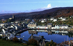
East Loch Tarbert, Argyll
Encyclopedia
Loch
Loch is the Irish and Scottish Gaelic word for a lake or a sea inlet. It has been anglicised as lough, although this is pronounced the same way as loch. Some lochs could also be called a firth, fjord, estuary, strait or bay...
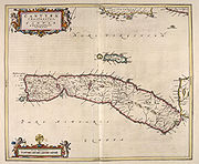
on the eastern side of the Kintyre
Kintyre
Kintyre is a peninsula in western Scotland, in the southwest of Argyll and Bute. The region stretches approximately 30 miles , from the Mull of Kintyre in the south, to East Loch Tarbert in the north...
peninsula in Scotland
Scotland
Scotland is a country that is part of the United Kingdom. Occupying the northern third of the island of Great Britain, it shares a border with England to the south and is bounded by the North Sea to the east, the Atlantic Ocean to the north and west, and the North Channel and Irish Sea to the...
. It is a part of the much larger Loch Fyne
Loch Fyne
Loch Fyne is a sea loch on the west coast of Argyll and Bute, Scotland. It extends inland from the Sound of Bute, making it the longest of the sea lochs...
. The village of Tarbert
Tarbert, Argyll and Bute
Tarbert is a village in Scotland. It is built around East Loch Tarbert, an inlet of Loch Fyne, and extends over the isthmus which links the peninsula of Kintyre to Knapdale and West Loch Tarbert...
lies along the shores of the loch, which is separated from West Loch Tarbert
West Loch Tarbert, Argyll
West Loch Tarbert, Argyll is a long and narrow sea loch on the western side of the Kintyre peninsula in Scotland.-Geography:The head of the loch lies near the village of Tarbert and it reaches the open sea at Ardpatrick Point some distant....
by an isthmus
Isthmus
An isthmus is a narrow strip of land connecting two larger land areas usually with waterforms on either side.Canals are often built through isthmuses where they may be particularly advantageous to create a shortcut for marine transportation...
only 1.5 kilometre (0.93205910497471 mi) long.
This sheltered loch became an important landing place for herring fishermen from at least AD 836 when it was mentioned in the Annals of Ulster
Annals of Ulster
The Annals of Ulster are annals of medieval Ireland. The entries span the years between AD 431 to AD 1540. The entries up to AD 1489 were compiled in the late 15th century by the scribe Ruaidhrí Ó Luinín, under his patron Cathal Óg Mac Maghnusa on the island of Belle Isle on Lough Erne in the...
.
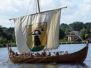
According to Snorri Sturluson
Snorri Sturluson
Snorri Sturluson was an Icelandic historian, poet, and politician. He was twice elected lawspeaker at the Icelandic parliament, the Althing...
's Heimskringla
Heimskringla
Heimskringla is the best known of the Old Norse kings' sagas. It was written in Old Norse in Iceland by the poet and historian Snorri Sturluson ca. 1230...
, Magnus Barefoot
Magnus III of Norway
Magnus Barefoot or Magnus III Olafsson was King of Norway from 1093 until 1103 and King of Mann and the Isles from 1099 until 1103.-Background:...
, King of Norway, had his longship
Longship
Longships were sea vessels made and used by the Vikings from the Nordic countries for trade, commerce, exploration, and warfare during the Viking Age. The longship’s design evolved over many years, beginning in the Stone Age with the invention of the umiak and continuing up to the 9th century with...
dragged across this isthmus as part of a campaign to increase his possessions in the Hebrides
Hebrides
The Hebrides comprise a widespread and diverse archipelago off the west coast of Scotland. There are two main groups: the Inner and Outer Hebrides. These islands have a long history of occupation dating back to the Mesolithic and the culture of the residents has been affected by the successive...
. He made an arrangement with King Malcolm III of Scotland
Malcolm III of Scotland
Máel Coluim mac Donnchada , was King of Scots...
that he could take possession of land on the west coast around which a ship could sail. Magnus declared that Kintyre had "better land than the best of the Hebrides", and by taking command of his ship's tiller and "sailing" across the isthmus he was able to claim the entire peninsula, which remained under Norse rule for more than a dozen years as a result.
More than two centuries later Robert the Bruce
Robert I of Scotland
Robert I , popularly known as Robert the Bruce , was King of Scots from March 25, 1306, until his death in 1329.His paternal ancestors were of Scoto-Norman heritage , and...
completed a similar feat during the Scottish Wars of Independence
Wars of Scottish Independence
The Wars of Scottish Independence were a series of military campaigns fought between the independent Kingdom of Scotland and the Kingdom of England in the late 13th and early 14th centuries....
in order to impress the clan chieftains of Argyll. He used tree trunks as rollers.
In the 18th century Thomas Pennant
Thomas Pennant
Thomas Pennant was a Welsh naturalist and antiquary.The Pennants were a Welsh gentry family from the parish of Whitford, Flintshire, who had built up a modest estate at Bychton by the seventeenth century...
recorded that sea-going vessels of up to 10 tonnes (9.8 LT) were being hauled over the isthmus in order to avoid the dangers of storms and tidal races in the seas surrounding the Mull of Kintyre
Mull of Kintyre
The Mull of Kintyre is the southwesternmost tip of the Kintyre Peninsula in southwest Scotland. From here, the Antrim coast is visible and an historic lighthouse, the second commissioned in Scotland, guides shipping in the intervening North Channel...
. James Watt surveyed the area and decided that it was feasible to construct a canal between the two lochs. Some 60 years later it was estimated that the cost for a cut without locks would be £90,000 but delays in implementation and the construction of the Crinan canal
Crinan Canal
The Crinan canal is a canal in the west of Scotland. It takes its name from the village of Crinan at its westerly end. Nine miles long, it connects the village of Ardrishaig on Loch Gilp with the Sound of Jura, providing a navigable route between the Clyde and the Inner Hebrides, without the need...
in 1801 rendered the plan redundant.
In the modern era the Tarbert (Loch Fyne) Harbour Commissioners control the loch, an area defined as "from the point of Garvell on the North, to the Oakenhead or Rudha Loigste point on the South". There are various quays and slipways in the inner harbour and 80 pontoon berths for yachts and other leisure craft.