
List of Orkney islands
Encyclopedia
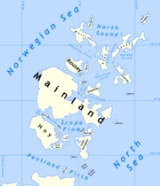
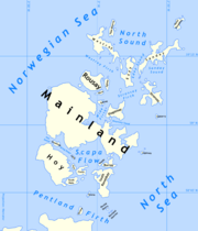
This is a list of Orkney islands in Scotland
. The Orkney archipelago
is located 16 kilometres (9.9 mi) north of mainland Scotland
and comprises over 70 islands and skerries
, of which 20 are inhabited. In addition to the Orkney Mainland there are three groups of islands. The North and South Isles lie respectively north and south of Mainland. The Pentland Skerries
are a group of small islands in the Pentland Firth
, a dangerous stretch of water between mainland Scotland and the larger islands of Orkney, through which run the strongest tidal streams in Britain. The Isle of Stroma
is often mistakenly included with the Orkney Islands, but is part of Caithness
.
 The definition of an island used in this list is that it is 'land that is surrounded by seawater on a daily basis, but not necessarily at all stages of the tide, excluding human devices such as bridges and causeways'. There are four islands joined to the Orkney Mainland by a series of causeway
s known as the Churchill Barriers
. They are South Ronaldsay
, Burray
, Lamb Holm
and Glims Holm
. In addition, Hunda
is connected to Burray by a causeway. The barriers were constructed by Italian prisoners-of-war as a means of preventing enemy submarine
access to the vast natural harbour of Scapa Flow
after the sinking of HMS Royal Oak by a German
U-boat
in 1939 with the loss of 883 lives. The Italian prisoners constructed a small Roman Catholic chapel
on Lamb Holm as a place of worship during their incarceration.
Most of the islands have a bedrock formed from Old Red Sandstone
, which is circa 400 million years old, and was laid down in the Devonian
period. The islands have good agricultural qualities and have been continuously inhabited for thousands of years, as evidenced by the World Heritage Site
of the Heart of Neolithic Orkney
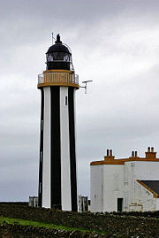
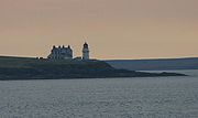
. The archipelago is exposed to wind and tide, and there are numerous lighthouse
s as an aid to navigation. The European Marine Energy Centre, which is located at Stromness
, is currently testing various wave
and tidal energy devices from Billia Croo on the Mainland and Eday
. The islands all fall within the Orkney Islands Council area. Most of the larger islands have development trust
s that support the local economy.
 This is a list of islands with an area greater than 15 hectares (approximately 37 acres). Records for the last date of settlement for the smaller uninhabited islands are incomplete, but all of the islands listed here would have been inhabited at some point during the Neolithic
, Pictish
or Norse
periods.
'Ward Hill' or a variant thereof is very common as the name of the highest point on the island. These locations are named after those high places used for the lighting of warning beacons
.

 This is a continuing list of uninhabited smaller Orkney islands (many of which are called "Holm
" from the Old Norse
holmr, meaning a small and rounded islet), tidal islets only separated at higher stages of the tide, or skerries which are only exposed at lower stages of the tide.
In the vicinity of:
The remote islets of Sule Skerry
and Sule Stack
, which lie 37 miles (59.5 km) west of the archipelago form part of Orkney for local government purposes.
Scotland
Scotland is a country that is part of the United Kingdom. Occupying the northern third of the island of Great Britain, it shares a border with England to the south and is bounded by the North Sea to the east, the Atlantic Ocean to the north and west, and the North Channel and Irish Sea to the...
. The Orkney archipelago
Archipelago
An archipelago , sometimes called an island group, is a chain or cluster of islands. The word archipelago is derived from the Greek ἄρχι- – arkhi- and πέλαγος – pélagos through the Italian arcipelago...
is located 16 kilometres (9.9 mi) north of mainland Scotland
Scotland
Scotland is a country that is part of the United Kingdom. Occupying the northern third of the island of Great Britain, it shares a border with England to the south and is bounded by the North Sea to the east, the Atlantic Ocean to the north and west, and the North Channel and Irish Sea to the...
and comprises over 70 islands and skerries
Skerry
A skerry is a small rocky island, usually defined to be too small for habitation. It may simply be a rocky reef. A skerry can also be called a low sea stack....
, of which 20 are inhabited. In addition to the Orkney Mainland there are three groups of islands. The North and South Isles lie respectively north and south of Mainland. The Pentland Skerries
Pentland Skerries
The Pentland Skerries are a group of four uninhabited islands lying in the Pentland Firth, northeast of Duncansby Head and south of South Ronaldsay in Scotland....
are a group of small islands in the Pentland Firth
Pentland Firth
The Pentland Firth , which is actually more of a strait than a firth, separates the Orkney Islands from Caithness in the north of Scotland.-Etymology:...
, a dangerous stretch of water between mainland Scotland and the larger islands of Orkney, through which run the strongest tidal streams in Britain. The Isle of Stroma
Stroma, Scotland
Stroma is an island off the northern coast of the Scottish mainland. It is the more southerly of the two islands in the Pentland Firth between the Orkney Islands and Caithness. It is administratively part of Caithness , while its neighbour Swona, to the north, is part of the Orkney Islands...
is often mistakenly included with the Orkney Islands, but is part of Caithness
Caithness
Caithness is a registration county, lieutenancy area and historic local government area of Scotland. The name was used also for the earldom of Caithness and the Caithness constituency of the Parliament of the United Kingdom . Boundaries are not identical in all contexts, but the Caithness area is...
.
Causeway
In modern usage, a causeway is a road or railway elevated, usually across a broad body of water or wetland.- Etymology :When first used, the word appeared in a form such as “causey way” making clear its derivation from the earlier form “causey”. This word seems to have come from the same source by...
s known as the Churchill Barriers
Churchill Barriers
The Churchill Barriers are a series of four causeways in the Orkney Islands, Scotland, with a total length of 1.5 miles . They link the Orkney Mainland in the north to the island of South Ronaldsay via Burray and the two smaller islands of Lamb Holm and Glimps Holm.The barriers were built in the...
. They are South Ronaldsay
South Ronaldsay
South Ronaldsay is one of the Orkney Islands off the north coast of Scotland. It is linked to the Orkney Mainland by the Churchill Barriers, running via Burray, Glimps Holm and Lamb Holm.-Geography and geology:...
, Burray
Burray
Burray is one of the Orkney Islands in Scotland. It lies to the east of Scapa Flow and is one of a chain of islands linked by the Churchill Barriers.-Geography and geology:...
, Lamb Holm
Lamb Holm
Lamb Holm is a small uninhabited island in Orkney, Scotland. The remarkable Italian Chapel, constructed during the Second World War, is the island's main attraction.-Geography:...
and Glims Holm
Glims Holm
Glims Holm is a small uninhabited islet in Orkney, Scotland.-Geography:Glims Holm lies in Holm Sound, one of the eastern entrances to Scapa Flow, between Mainland, Orkney and the island of Burray, The Churchill Barriers link South Ronaldsay to the Orkney Mainland...
. In addition, Hunda
Hunda
Hunda is an uninhabited island in the Orkney archipelago in Scotland. It is in extent and rises to above sea level. It is situated in the Scapa Flow and connected to the nearby island of Burray by a causeway built in 1941 to stop passage of small surface craft as part of the boom defences, and...
is connected to Burray by a causeway. The barriers were constructed by Italian prisoners-of-war as a means of preventing enemy submarine
Submarine
A submarine is a watercraft capable of independent operation below the surface of the water. It differs from a submersible, which has more limited underwater capability...
access to the vast natural harbour of Scapa Flow
Scapa Flow
right|thumb|Scapa Flow viewed from its eastern endScapa Flow is a body of water in the Orkney Islands, Scotland, United Kingdom, sheltered by the islands of Mainland, Graemsay, Burray, South Ronaldsay and Hoy. It is about...
after the sinking of HMS Royal Oak by a German
Germany
Germany , officially the Federal Republic of Germany , is a federal parliamentary republic in Europe. The country consists of 16 states while the capital and largest city is Berlin. Germany covers an area of 357,021 km2 and has a largely temperate seasonal climate...
U-boat
U-boat
U-boat is the anglicized version of the German word U-Boot , itself an abbreviation of Unterseeboot , and refers to military submarines operated by Germany, particularly in World War I and World War II...
in 1939 with the loss of 883 lives. The Italian prisoners constructed a small Roman Catholic chapel
Italian Chapel
The Italian Chapel is a highly ornate Catholic chapel on Lamb Holm in Orkney, Scotland. It was built by Italian prisoners of war during World War II, who were housed on the previously uninhabited island while they constructed the Churchill Barriers to the east of Scapa Flow. Only the concrete...
on Lamb Holm as a place of worship during their incarceration.
Most of the islands have a bedrock formed from Old Red Sandstone
Old Red Sandstone
The Old Red Sandstone is a British rock formation of considerable importance to early paleontology. For convenience the short version of the term, 'ORS' is often used in literature on the subject.-Sedimentology:...
, which is circa 400 million years old, and was laid down in the Devonian
Devonian
The Devonian is a geologic period and system of the Paleozoic Era spanning from the end of the Silurian Period, about 416.0 ± 2.8 Mya , to the beginning of the Carboniferous Period, about 359.2 ± 2.5 Mya...
period. The islands have good agricultural qualities and have been continuously inhabited for thousands of years, as evidenced by the World Heritage Site
World Heritage Site
A UNESCO World Heritage Site is a place that is listed by the UNESCO as of special cultural or physical significance...
of the Heart of Neolithic Orkney
Heart of Neolithic Orkney
Heart of Neolithic Orkney refers to a group of Neolithic monuments found on the Mainland, one of the islands of Orkney, Scotland. The name was adopted by UNESCO when it proclaimed these sites as a World Heritage Site in 1999....
. The archipelago is exposed to wind and tide, and there are numerous lighthouse
Lighthouse
A lighthouse is a tower, building, or other type of structure designed to emit light from a system of lamps and lenses or, in older times, from a fire, and used as an aid to navigation for maritime pilots at sea or on inland waterways....
s as an aid to navigation. The European Marine Energy Centre, which is located at Stromness
Stromness
Stromness is the second-biggest town in Orkney, Scotland. It is in the south-west of Mainland Orkney. It is also a parish, with the town of Stromness as its capital.-Etymology:...
, is currently testing various wave
Wave power
Wave power is the transport of energy by ocean surface waves, and the capture of that energy to do useful work — for example, electricity generation, water desalination, or the pumping of water...
and tidal energy devices from Billia Croo on the Mainland and Eday
Eday
Eday is one of the Orkney Islands, which are located to the north of the Scottish mainland in the United Kingdom. Eday is located in the North Isles of Orkney, and is about north of the main island of Orkney Mainland...
. The islands all fall within the Orkney Islands Council area. Most of the larger islands have development trust
Development trust
Development Trusts are organisations which operate in the United Kingdom that are:*community based, owned and led*engaged in the economic, environmental and social regeneration of a defined area or community...
s that support the local economy.
Main list
Neolithic
The Neolithic Age, Era, or Period, or New Stone Age, was a period in the development of human technology, beginning about 9500 BC in some parts of the Middle East, and later in other parts of the world. It is traditionally considered as the last part of the Stone Age...
, Pictish
Picts
The Picts were a group of Late Iron Age and Early Mediaeval people living in what is now eastern and northern Scotland. There is an association with the distribution of brochs, place names beginning 'Pit-', for instance Pitlochry, and Pictish stones. They are recorded from before the Roman conquest...
or Norse
Viking
The term Viking is customarily used to refer to the Norse explorers, warriors, merchants, and pirates who raided, traded, explored and settled in wide areas of Europe, Asia and the North Atlantic islands from the late 8th to the mid-11th century.These Norsemen used their famed longships to...
periods.
'Ward Hill' or a variant thereof is very common as the name of the highest point on the island. These locations are named after those high places used for the lighting of warning beacons
Beacon
A beacon is an intentionally conspicuous device designed to attract attention to a specific location.Beacons can also be combined with semaphoric or other indicators to provide important information, such as the status of an airport, by the colour and rotational pattern of its airport beacon, or of...
.
| Island | Group | Area (ha Hectare The hectare is a metric unit of area defined as 10,000 square metres , and primarily used in the measurement of land. In 1795, when the metric system was introduced, the are was defined as being 100 square metres and the hectare was thus 100 ares or 1/100 km2... ) |
Population | Last inhabited | Highest point | Height (m) |
|---|---|---|---|---|---|---|
| Auskerry Auskerry Auskerry is a small island in eastern Orkney, Scotland. It lies in the North Sea south of Stronsay and has a lighthouse, completed in 1866.-Description:... |
North Isles | 85 | 5 | West Hill | 18 | |
| Brough of Birsay Brough of Birsay - Lighthouse :An unmanned lighthouse on the Brough was built in 1925 by David A Stevenson.-References:... |
Mainland | 21 | 0 | unknown | Brough Head | 42 |
| Burray Burray Burray is one of the Orkney Islands in Scotland. It lies to the east of Scapa Flow and is one of a chain of islands linked by the Churchill Barriers.-Geography and geology:... |
South Isles | 903 | 357 | 80 | ||
| Calf of Eday Calf of Eday The Calf of Eday is an island in Orkney, Scotland, lying north east of Eday."Calf" is a name usually given to a small island alongside a larger one, e.g... |
North Isles | 243 | 0 | unknown | 54 | |
| Cava Cava, Orkney Cava is an uninhabited island in the Orkney archipelago in Scotland. It is in extent and rises to above sea level. The literal meaning of the name is 'calf island', a terminology often used to designate a small island near to a larger one... |
South Isles | 107 | 0 | 1990s | 38 | |
| Copinsay Copinsay 'Copinsay is one of the Orkney Islands in Scotland, lying off the east coast of the Orkney Mainland. The smaller companion island to Copinsay is called the Horse of Copinsay and lies to the north east to the main island. The island is now uninhabited and managed as a bird reserve... |
South Isles | 73 | 0 | 1970s | Broad Lee | 70 |
| Damsay Damsay Damsay is an island in the Orkney archipelago in Scotland. It is approximately 18 hectares in extent and rises to only 11 metres above sea level. It is situated in the Bay of Firth north of the Orkney Mainland near Finstown... |
North Isles | 18 | 0 | unknown | 11 | |
| Eday Eday Eday is one of the Orkney Islands, which are located to the north of the Scottish mainland in the United Kingdom. Eday is located in the North Isles of Orkney, and is about north of the main island of Orkney Mainland... |
North Isles | 2745 | 121 | Ward Hill | 101 | |
| Egilsay Egilsay Egilsay is one of the Orkney Islands in Scotland, lying east of Rousay. The island is largely farmland and is known for its corncrakes.-St. Magnus Church:... |
North Isles | 650 | 37 | 35 | ||
| Eynhallow Eynhallow Eynhallow is a small, presently uninhabited island, part of the Orkney Islands, off the north coast of Scotland.-Geography:Eynhallow lies in Eynhallow Sound between Mainland, Orkney and Rousay. It is in area.... |
North Isles | 75 | 0 | 1842-90 | 30 | |
| Fara Fara, Orkney Fara is a small island in Orkney, Scotland, lying in Scapa Flow between the islands of Flotta and Hoy. It has been uninhabited since the 1960s.-Footnotes:... |
South Isles | 295 | 0 | 1960s | Thomson's Hill | 43 |
| Faray Faray Faray is a small island in Orkney, Scotland, lying between Eday and Westray. Previously inhabited, the low-lying island is now a successful Grey Seal breeding colony.-Geography:... |
North Isles | 180 | 0 | 1940s | 32 | |
| Flotta Flotta Flotta is a small island in Orkney, Scotland, lying in Scapa Flow. The island is known for its large oil terminal and is linked by Orkney Ferries to Houton on the Orkney Mainland and Lyness and Longhope on Hoy.... |
South Isles | 876 | 81 | West Hill | 58 | |
| Gairsay Gairsay Gairsay is a small island in Orkney, Scotland, located in the parish of Rendall, off the coast, astride one of the approaches to the bays of Firth and Kirkwall... |
North Isles | 240 | 3 | 102 | ||
| Glims Holm Glims Holm Glims Holm is a small uninhabited islet in Orkney, Scotland.-Geography:Glims Holm lies in Holm Sound, one of the eastern entrances to Scapa Flow, between Mainland, Orkney and the island of Burray, The Churchill Barriers link South Ronaldsay to the Orkney Mainland... |
South Isles | 55 | 0 | unknown | 32 | |
| Graemsay Graemsay Graemsay is an island in the western approaches to Scapa Flow, in the Orkney Islands of Scotland. The island has two lighthouses.-Geography and geology:... |
South Isles | 409 | 21 | West Hill | 62 | |
| Holm of Papa Holm of Papa The Holm of Papa is a very small uninhabited island in the Orkney islands. It is around 15 ha in size... |
North Isles | 22 | 0 | unknown | 15 | |
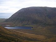
| Hoy Hoy Hoy is an island in Orkney, Scotland. With an area of it is the second largest in the archipelago after the Mainland. It is connected by a causeway called The Ayre to South Walls... |
South Isles | 13468 | 272 | Ward Hill Ward Hill, Hoy Ward Hill, on the island of Hoy, is the highest hill in Orkney, Scotland. It lies at the north of the island, between Moaness and Rackwick.The hill forms a curved ridge, reminiscent of a 'J' in shape. The lower slopes are covered in heather and grass, though the top of the ridge is covered in small... |
479 | |
| Hunda Hunda Hunda is an uninhabited island in the Orkney archipelago in Scotland. It is in extent and rises to above sea level. It is situated in the Scapa Flow and connected to the nearby island of Burray by a causeway built in 1941 to stop passage of small surface craft as part of the boom defences, and... |
South Isles | 100 | 0 | unknown | 41 | |
| Lamb Holm Lamb Holm Lamb Holm is a small uninhabited island in Orkney, Scotland. The remarkable Italian Chapel, constructed during the Second World War, is the island's main attraction.-Geography:... |
South Isles | 40 | 0 | 1945 | 20 | |
| Linga Holm | North Isles | 57 | 0 | 1842-90 | 18 | |
| Muckle Green Holm Muckle Green Holm Muckle Green Holm is an uninhabited island in the North Isles of the Orkney archipelago in Scotland. It is roughly in extent and rises to 28 metres above sea level, the summit having a trig point. The literal meaning of the name is somewhat contradictory. 'Holm' is from the Old Norse holmr,... |
North Isles | 32 | 0 | unknown | 28 | |
| Muckle Skerry Muckle Skerry Muckle Skerry is the largest of the Pentland Skerries that lie off the north coast of Scotland. It is home to the Pentland Skerries Lighthouse.Muckle Skerry lies in the Pentland Firth at . It is the westernmost of the skerries... |
Pentland Skerries | 34 | 0 | 1994 | 20 | |
| North Ronaldsay North Ronaldsay North Ronaldsay is the northernmost of the Orkney Islands, Scotland and with an area of is the fourteenth largest.-Geography:North Ronaldsay lies around north of its nearest neighbour, Sanday at . The island is around long along its length and is defined by two large sandy bays; Linklet Bay on... |
North Isles | 690 | 70 | 23 | ||
| Orkney Mainland | Mainland | 52325 | 15315 | Mid Hill | 271 | |
| Papa Stronsay Papa Stronsay Papa Stronsay is a small island in Orkney, Scotland, lying north east of Stronsay. It is in size, and at its highest point.According to folklore, some of the natives were descended from a female selkie. This was because they had horny skin on their feet and hands, and permanently smelt of... |
North Isles | 74 | 10 | 13 | ||
| Papa Westray Papa Westray Papa Westray, also known as Papay, is one of the Orkney Islands in Scotland, with a population of 65 at the time of the 2001 Census, now increased to 70 people... |
North Isles | 918 | 65 | North Hill | 48 | |
| Rysa Little Rysa Little Rysa Little is an uninhabited island in the Orkney archipelago in Scotland. It is approximately 32 hectares in extent and rises to 20 metres above sea level.... |
South Isles | 32 | 0 | 19th century | 20 | |
| Rousay Rousay Rousay is a small, hilly island about north of Orkney's Mainland, off the north coast of Scotland, and has been nicknamed "the Egypt of the north", due to its tremendous archaeological diversity and importance.... |
North Isles | 4860 | 212 | Blotchnie Fiold | 250 | |
| Sanday Sanday, Orkney Sanday is one of the inhabited islands in the Orkney Islands, off the north coast of Scotland. With an area of , it is the third largest of the Orkney Islands. The main centres of population are Lady Village and Kettletoft. Sanday can be reached by Orkney Ferries or plane from Kirkwall on the... |
North Isles | 5043 | 478 | The Wart | 65 | |
| Shapinsay Shapinsay Shapinsay is one of the Orkney Islands off the north coast of mainland Scotland. There is one village on the island, Balfour, from which roll-on/roll-off car ferries sail to Kirkwall on the Orkney Mainland... |
North Isles | 2948 | 300 | Ward Hill | 64 | |
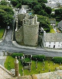
| South Ronaldsay South Ronaldsay South Ronaldsay is one of the Orkney Islands off the north coast of Scotland. It is linked to the Orkney Mainland by the Churchill Barriers, running via Burray, Glimps Holm and Lamb Holm.-Geography and geology:... |
South Isles | 4980 | 854 | Ward Hill | 118 | |
| South Walls South Walls South Walls is an inhabited island adjacent to Hoy in Orkney, Scotland. The name is a corruption of "Sooth Was", which means the "southern voes" - as with Kirkwall, it was assumed that it was a mispronunciation of "walls".... |
South Isles | 850 | 120 | Gallow Tuag | 57 | |
| Stronsay Stronsay Stronsay is an island in Orkney, off the north coast of Scotland. The main village is Whitehall, home to a heritage centre. It is in size, and at its highest point.... |
North Isles | 3275 | 343 | Burgh Hill | 44 | |
| Switha Switha Switha is a small island in Orkney, Scotland, south of Flotta, used for grazing sheep. There is no written record of the island ever being inhabited, but Neolithic standing stones and a cairn show that it was at least visited in prehistoric times.... |
South Isles | 41 | 0 | 20th century? | 29 | |
| Swona Swona Swona is an uninhabited island in the Pentland Firth off the north coast of Scotland.-Geography and geology:Swona is the more northerly of two islands in the Pentland Firth between the Orkney Islands and Caithness on the Scottish mainland... |
South Isles | 92 | 0 | 1974 | Warbister Hill | 41 |
| Westray Westray Westray is one of the Orkney Islands in Scotland, with a population of around 550 people. Its main village is Pierowall, with a heritage centre, the ruined Lady Kirk and ferries to Papa Westray.-Geography and geology:... |
North Isles | 4713 | 563 | Fitty Hill | 169 | |
| Wyre Wyre, Orkney Wyre, also formerly spelt Weir, is one of the Orkney Islands, lying south-east of Rousay. It is and at its highest point. It is one of the smallest inhabited islands in the archipelago.... |
North Isles | 311 | 18 | 32 |
Smaller islets and skerries
Holm (island)
This page is a set index; for other uses of the term, see Holm There are numerous islands containing the word Holm, especially in Scotland. In many cases the name is derived from the Old Norse holmr, meaning "a small and rounded islet"...
" from the Old Norse
Old Norse
Old Norse is a North Germanic language that was spoken by inhabitants of Scandinavia and inhabitants of their overseas settlements during the Viking Age, until about 1300....
holmr, meaning a small and rounded islet), tidal islets only separated at higher stages of the tide, or skerries which are only exposed at lower stages of the tide.
In the vicinity of:
- Auskerry: Lunga Skerries, Oessen Skerry, The Clett.
- Calf of Eday: Lashy Skerries, The Bow.
- Cava: Barrel of ButterBarrel of ButterThe Barrel of Butter is a rock in the Orkney Islands-Geography and geology:The rock is old red sandstone of the Devonian period. There is no soil of any significance on it....
. - Copinsay: Black HolmBlack HolmBlack Holm is a small tidal island in the Orkney Islands, near Copinsay to the west of Corn Holm.-Geography and geology:Corn Holm is made up of red sandstone....
, Corn HolmCorn HolmCorn Holm is a small tidal island in Orkney, near Copinsay to the west. There was once a small chapel here , and it is covered in birdlife.- Geography and geology :Corn Holm is made up of red sandstone....
, Horse of CopinsayHorse of CopinsayThe Horse of Copinsay, also known as the Horse, is a rectangular sea stack to the north east of Copinsay in the Orkney Islands.-Name:...
, Scarf Skerry, Sow Skerry, Ward Holm. - Eday: Green Holm, Red Holm, Rusk HolmRusk Holm-History:There is a prehistoric cairn on it.Rusk Holm is also home to "Holmie Sheep", which are similar to the North Ronaldsay sheep.-References:...
. - Egilsay: Holm of ScocknessHolm of ScocknessThe Holm of Scockness is a small island in the Orkney Islands, between Rousay and Egilsay.It is currently used for grazing.Its name is Norse in origin and means "little island of the crooked headland".-Geography and geology:...
, Kili HolmKili HolmKili Holm is a tidal island in the Orkney Islands, linked to Egilsay. Unusually, like its neighbour Egilsay, it may have a partly Gaelic etymology, in this case from cille meaning a monk’s cell...
. - Eynhallow: Sheep Skerry.
- Flotta: Calf of FlottaCalf of FlottaThe Calf of Flotta is a small island in Scapa Flow, Orkney. The Calf is next to Flotta, with "Calf" deriving from Old Norse/Norn and meaning a smaller island by a larger one.-Geography and geology:The Calf is made of red sandstone....
. - Gairsay: Holm of Boray, Holm of Rendall, Little Seal Skerry, Skertours, Sweyn HolmSweyn HolmNote: There is also a "Sweyn Holm" off St Ninian's Isle, ShetlandSweyn Holm is a small island in the Orkney Islands, next to Gairsay.It is thought to be named for Sweyn Asleifsson , who was connected with Gairsay or possibly a corruption of "servant's island" in Norse.-References:...
, Taing Skerry. - Glims Holm: Dulse Skerry, Glimpsholm Skerry.
- Graemsay: Middle Skerry, Skerry of Cletts, Sour Skerry, Sow Skerry.
- Hoy: Grassy Cletts, Inner Skerry, Middle Skerry, Old Man of HoyOld Man of HoyThe Old Man of Hoy is a sea stack of red sandstone perched on a plinth of igneous basalt rock, close to Rackwick Bay on the west coast of the island of Hoy, in the Orkney Islands, Scotland. It is a distinctive landmark seen from the Thurso to Stromness ferry, MV Hamnavoe, and is a famous rock climb...
, Outer Skerry, The Needle. - Mainland: Bo Skerry, Bow Skerries, Braga, Brough of Bigging, Holm of HoutonHolm of Houton-Geography:The Holm is in Midland Harbour, part of Scapa Flow. It is south of the Mainland parish of Orphir, near Houton whence its name.The Holm is north of Cava and Rysa Little, and to the north west of Hoy over the Bring Deeps.-References:...
, Holm of Grimbister, Holm of Rendall, Iceland Skerry, Inner Holm, Kirk Rocks, Little Skerry, Mirkady Point, Nevi Skerry, Outer Holm, Oyster Skerries, Puldrite Skerry, Quanterness Skerry, Scare Gun, Seal Skerry, Skaill Skerries, Skerries of Clestrain, Skerries of Coubister, Skerries of Lakequoy, Skerry of Work, Skerry of Yinstay, Smoogro Skerry, Thieves HolmThieves HolmThieves Holm is a small island in the Orkney Islands.-Geography and geology:Thieves Holm is due north of Mainland, Orkney at the mouth of Kirkwall Bay, between the Mainland and the isle of Shapinsay. It is at the west end of the strait between Mainland and Shapinsay, known as the String. It is...
, Whyabatten, Yesnaby Castle. - Muckle Skerry: Clettack Skerry, Little Skerry, Louther Skerry.
- North Ronaldsay: Altars of Linnay, Green Skerry, Hoe Skerries, Reefdyke, Seal Skerry.
- Papa Stronsay: Jack's Hole, Jack's Reef.
- Papa Westray: Cairn Head, Muckle Quoy.
- Rousay: Little Brig, Muckle Brig.
- Sanday: Baa Gruna, Start Point.
- Shapinsay: Broad Shoal, Grass Holm, Helliar HolmHelliar HolmHelliar Holm is an uninhabited island off the coast of Shapinsay in the Orkney Islands, Scotland. It is home to a lighthouse, which was built in 1893 and automated in 1967...
, Skerry of Vasa. - Stronsay: Holm of HuipHolm of HuipThe Holm of Huip is a small island in the Orkney Islands, in Spurness Sound to the north west of Stronsay.The Holm has a cairn on it, and a number of grey seals.-Geography and geology:Like most of Orkney, the Holm is formed from Old Red Sandstone....
, Holms of Spurness, Ingale Skerry, Little Linga, The Bow. - Swona: Selki Skerry, South Clett, The Tails of the Tarff, West Wini Skerry.
- Westray: Holm of Aikerness, Holm of FarayHolm of FarayThe Holm of Faray is a small island in Orkney, Scotland, near Faray and Westray, which it lies between. Together with its neighbour Faray, it is designated a SSSI due to its importance as a haul-out site and breeding area for grey seals....
, Shell Holm, Skea Skerries, Wart Holm. - Wyre: Wyre Skerries.
The remote islets of Sule Skerry
Sule Skerry
Sule Skerry is a remote skerry in the North Atlantic off the north coast of Scotland.-Geography:Sule Skerry lies 60 kilometres west of the Orkney Mainland at . Sule Skerry's sole neighbour, Sule Stack, lies 10km to the southwest. The remote islands of Rona and Sula Sgeir lie approximately 80km...
and Sule Stack
Sule Stack
Sule Stack or Stack Skerry is an extremely remote island or stack in the North Atlantic off the north coast of Scotland. It is formed of Lewisian gneiss.Sule Stack lies 66 kilometres west of the Orkney mainland at...
, which lie 37 miles (59.5 km) west of the archipelago form part of Orkney for local government purposes.