
Lady Isle
Encyclopedia
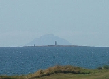
Lady Isle is a small, uninhabited island, in the Firth of Clyde
, Scotland
. It was once home to a chapel dedicated to Saint Mary. The island features an interesting lighthouse and a freshwater spring.
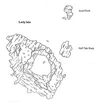
. The island is around 0.6 kilometres along its length and rises to a maximum height of just 6 metres. Half tide, Scart rocks and Seal rock are associated with Lady Isle. The island lies in the parish of Dundonald
in South Ayrshire
.
's map of 1604 - 1608 published in 1654 by Joan Blaeu
, marks Lady Isle by that name and indicates that a structure is present on the island, presumably the chapel. In c. 1636 - 1662 Robert Gordon's manuscript map marks the isle as 'Lady Yle' and shows two islands.
John Adair
in his 1686 A mape of the west of Scotland containing Clydsdail, Nithsdail, Ranfrew, Shyre of Ayre, & Galloway. shows Lady Isle as Mary Isle and indicates a chapel as being located on the island. In 1745 Moll used the name Lady Isle.
 When Edward I of England
came to Ayr
in 1299 following the burning of the Barns of Ayr, Hermingford, an old chronicler of the period, records that:
It is thought that the name Isle of Ayr refers to Lady Isle.
The Geographical Collections relating to Scotland state:
Lady Isle is probably first mentioned in the title of William Fullarton of that Ilk, in his Charter under the Great Seal by William III
, dated 9 December 1695, which included "the five pound land of Aldtoun containing the little isle, opposite the lands of Corsbie, called the Lady-isl".
The island came into the possession of William Fullarton in 1698 and was purchased by the Marquess of Titchfield in 1805. When the Marquess was elevated to become the Duke of Portland the island was part of the Duke's Fullarton Estate.
 One suggestion is that the name "Lady" is actually derived from the Scottish Gaelic word Laidh, meaning a 'ship's course'. Lady Isle has probably always been important to navigators as is shown by the fact that in the 17th century, the Magistrates of Glasgow built two stone pillars on the Isle, and lining them up from the east gave a good anchorage from a
north west gale.
William Taylor, a member of a pleasure party from Ayr in the 1890s was hit by lightning during a storm and was killed instantly. He left a wife and three children.
In June, 1821, someone set fire to the "turf and pasture", and this act permanently destroyed the island's grazing, with gales blowing much of the island's soil into the sea. It is only slowly recovering. In June 1829, the Isle was let to Mr. William Fullarton of Skeldon, who restocked the Isle with rabbits. Fullarton built a house or lodge of some sort. The building was broken into several times and eventually a family of fishermen from Troon were arrested, tried and given a relatively small fine.
 Lady Isle was at one time connected with an ancient ecclesiastical establishment near Adamton, called Lady Kirk, and situated about four miles north of Ayr. As stated, a chapel was built, here dedicated to the Virgin Mary and endowed by John Blair in 1446 with the common land of Adamton. John Adair's map indicates a religious building as being located in the centre of the island and Pont also indicates a structure of some sort, well before any beacons were built. John Adair uses the name Mary Isle for the island, suggesting that this pre-reformation
(c.1560s) 'chapel', like so many others, was dedicated to Saint Mary. It is more than likely that the beacons were built using stones from this chapel or 'cell' and no signs now remain of this ecclesiastical structure. When the bird observatory and warden's post was being built, the architect noted that there were signs of some sort of ancient ecclesiastical building on the island.
 The town of Glasgow (c. 1776) set up a pair of beacons on Lady Isle to indicate the position of the anchorage, which was situated to the east or inshore, for the benefit of ships serving its merchants. This information is given on Armstrong's 1775 map. John Thomson's 1828 map marks two 'towers', one where the present 'beacon' stands and the other at the site of the present lighthouse. Herman Moll in 1745 shows no features at all on his map, but marks two islands.
The lighthouse was built on the site of one of the beacons and therefore the remaining 18th-century 'beacon' when aligned with the lighthouse continued to allow mariners to follow a safe course to a sheltered anchorage. Ships of over 220 tons, too large to enter the harbours of Saltcoats
[NS24SW 44.00], Irvine
[NS33NW 40.00] or Ayr
[NS32SW 123.00] could find anchorage in 10 to 14 fathoms [18 to 26m] in an area east of, and covered by Lady Isle [name: NS 275 293].
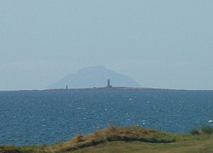
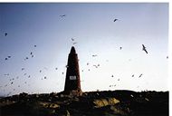
 Lady Isle is home to an interesting lighthouse. Established in 1903 the lighthouse
is not the standard round tower type but rather consists of a platform built on buttresses with an exterior stairwell. The light is still used as a navigational aid (Fl(4)30s19m8M) and is managed by the Northern Lighthouse Board. An X/S Band racon
radar
beacon, with S Band emissions restricted to landward is also on the lighthouse. A small wooden storage hut sits beside the lighthouse, rather oddly inscribed Social Security Appeals Tribunal. A large white horizontal cylinder used to hold the gas supply for the lighthouse light which was converted to electricity during the refurbishment and solarisation in around 2004. Regarding the approach to the island, mariners have to beware the drying rock all around the island up to 2 cables to the northeast (see the map).
 Lady Isle is owned by the Marquess of Ailsa
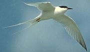
and was for many years leased out as a bird sanctuary with a bird observatory and warden's post built and run by the Scottish Society for the Protection of Wild Birds (SSPWB). Common Tern
s and Arctic Tern
s used to nest here and Roseate tern
s had been observed on may occasions. The observatory carries a sign saying that it was built In memory of Johnny Warren, honorary warden Lady Isle Sanctuary Troon who died 24 May 1958.
Lady Isle is said to have been Britain's first seabird reserve. The Scottish Natural Heritage
has designated the island as a Wild Bird Sanctuary under the Protection of Birds Act 1954 and as an Area of Special Protection, together with Horse island off Ardrossan
. Scart rock off the island is named from the Scots
for a cormorant
. Mr. Donald J. Cameron, was the architect for the SSPWB and he informed their Secretary that there were signs of some sort of ancient ecclesiastical building on the island.
bushes were growing over the well / spring during the 1993 Scottish Wildlife Trust visit.
 An Ordnance Survey
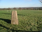
trig point
has been placed on the island, just in front of the bird observatory, indicating the 6m height point. This Trig point is a truncated square concrete pyramid, generally known as a Hotine Pillar. On the top is a brass plate with three arms and a central depression is fixed. A benchmark is set on the side, marked with the letters "O S B M" (Ordnance Survey Bench Mark) and the reference number. Within the trig point are concealed mountings for a specialized theodolite, which can be temporarily mounted on the trig point for measurements to be taken.
On 24 September 2000 a small group of Trig point enthusiasts visited the island as part of a quest to visit one trig point of every height in metres in Scotland, making 749 in total.
ships was wrecked here, and sank in deep water. She is said to have been carrying a gold throne on board, a gift to King Phillip of Spain. Troon men made many attempts to bring the Spanish treasures to the surface, but without success.
A professional Dutch diver was supposedly hired to do the salvage job, making his headquarters on the isle, with a store ship standing by. Upon discovering the wreck and entering he found the golden throne, on which was seated, a gigantic figure who rose and came towards him. When the diver grasped the hand of the figure, instead of a hand, he found that he was grasping a cloven hoof! He escaped the scene with his life and some of his wits intact, however no one has attempted further salvage attempts. One of the Masters of a Kilwinning Lodge was presented with a wooden mallet which had been made with wood from one of the Armada ships which had been wrecked on the Ayrshire coast.
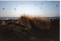
 Apart from the large numbers of gulls, Eider
s nest on the island. Shag
s and oystercatcher
s are frequently seen. A population of rabbit
s survive with partially collapsed burrows criss-crossing the parts of the islet with have a significant depth of soil. In the Statistical Account of Scotland of 1791,
under the Article on the Parish of Ayr, it confirms that the Isle is inhabited by rabbits. A large number of the common snail, Helix aspersa
species were noted on the 1993 SWT visit. One odd feature of the island was the very large numbers of animal bones, mostly of mammal origin, brought here by the gulls.
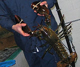
Seals are frequently seen on the island and the associated rocks,one of which is called Seal Rock. A Mr. William Allasson of Troon was tenant of the isle in 1811, and he was hindered by the large number of people who landed on the isle, causing damage to his flock of sheep, and stealing the rabbits. Lobsters were plentiful amongst the surrounding rocks and in the past the Duke of Portland went to considerable trouble to try and prevent 'poaching' of the lobster
s as he saw it.
Elder
bushes grow near the freshwater spring and sea pink
s are very common. As previously stated, a fire in the 19th-century resulted in the loss of much of the island's soil, the wind blowing it into the sea. The island has been designated site number 8725, an 'Area of Special Protection' by Scottish Natural Heritage
.
Smith records Sea Mouse-Ear (Cerastium diffusum), Narrow-leaved Mouse-ear (Cerastium triviale), Sea-Pearlwort (Sagina maritimum), Corn Spurrey (Spergula arvensis), Greater Sea-Spurrey (Spergularia media), Dovesfoot Cranesbill (Geranium molle), Common Stork's-bill (Erodium cicutarium), Common Vetch (Vicia sativa), Bramble (Rubus fruticosus), Common Silverweed (Argentina anserina), Marsh Cinquefoil (Potentilla palustris), and English Stonecrop (Sedum anglicum) for Lady Isle in the 1890s.
might take over the isle as a reserve, however the loss of the terns due to the large colony of herring and other gulls, together with a depletion of the flora, also due to the gulls, led to this proposal being rejected. Members visited the island on 19 May 1993 to assess its value as a reserve, taking the boat from Troon
harbour which regularly visits the island to maintain the lighthouse.
Firth of Clyde
The Firth of Clyde forms a large area of coastal water, sheltered from the Atlantic Ocean by the Kintyre peninsula which encloses the outer firth in Argyll and Ayrshire, Scotland. The Kilbrannan Sound is a large arm of the Firth of Clyde, separating the Kintyre Peninsula from the Isle of Arran.At...
, Scotland
Scotland
Scotland is a country that is part of the United Kingdom. Occupying the northern third of the island of Great Britain, it shares a border with England to the south and is bounded by the North Sea to the east, the Atlantic Ocean to the north and west, and the North Channel and Irish Sea to the...
. It was once home to a chapel dedicated to Saint Mary. The island features an interesting lighthouse and a freshwater spring.
Geography
Lady Isle lies some 2 miles [3.2 km] SW of TroonTroon
Troon is a town in South Ayrshire. It is situated on the west coast of Scotland, about eight miles north of Ayr and three miles northwest of Glasgow Prestwick International Airport. Lying across the Firth of Clyde, the Isle of Arran can be seen. Troon is also a port with freight and ferry services...
. The island is around 0.6 kilometres along its length and rises to a maximum height of just 6 metres. Half tide, Scart rocks and Seal rock are associated with Lady Isle. The island lies in the parish of Dundonald
Dundonald
Dundonald is a large settlement in County Down, Northern Ireland. It lies east of Belfast and is often deemed to be a suburb of the city. It includes the large housing estate of Ballybeen, and many new housing estates have emerged in the past ten years....
in South Ayrshire
South Ayrshire
South Ayrshire is one of 32 council areas of Scotland, covering the southern part of Ayrshire. It borders onto East Ayrshire, North Ayrshire and Dumfries and Galloway....
.
Evidence from old maps
Timothy PontTimothy Pont
Timothy Pont was a Scottish topographer, the first to produce a detailed map of Scotland. Pont's maps are among the earliest surviving to show a European country in minute detail, from an actual survey.-Life:...
's map of 1604 - 1608 published in 1654 by Joan Blaeu
Joan Blaeu
Joan Blaeu was a Dutch cartographer.He was born in Alkmaar, the son of cartographer Willem Blaeu.In 1620 he became a doctor of law but he joined the work of his father. In 1635 they published the Atlas Novus in two volumes...
, marks Lady Isle by that name and indicates that a structure is present on the island, presumably the chapel. In c. 1636 - 1662 Robert Gordon's manuscript map marks the isle as 'Lady Yle' and shows two islands.
John Adair
John Adair (surveyor)
John Adair was a Scottish surveyor and mapmaker, noted for the excellence of his maps.He first came to public notice in 1683, with a prospectus published in Edinburgh for a "Scottish Atlas" stating that the Privy Council of Scotland had engaged Adair, a "mathematician and skilfull mechanic", to...
in his 1686 A mape of the west of Scotland containing Clydsdail, Nithsdail, Ranfrew, Shyre of Ayre, & Galloway. shows Lady Isle as Mary Isle and indicates a chapel as being located on the island. In 1745 Moll used the name Lady Isle.
Written history
Edward I of England
Edward I , also known as Edward Longshanks and the Hammer of the Scots, was King of England from 1272 to 1307. The first son of Henry III, Edward was involved early in the political intrigues of his father's reign, which included an outright rebellion by the English barons...
came to Ayr
Ayr
Ayr is a town and port situated on the Firth of Clyde in south-west Scotland. With a population of around 46,000, Ayr is the largest settlement in Ayrshire, of which it is the county town, and has held royal burgh status since 1205...
in 1299 following the burning of the Barns of Ayr, Hermingford, an old chronicler of the period, records that:
It is thought that the name Isle of Ayr refers to Lady Isle.
The Geographical Collections relating to Scotland state:
Lady Isle is probably first mentioned in the title of William Fullarton of that Ilk, in his Charter under the Great Seal by William III
William III of England
William III & II was a sovereign Prince of Orange of the House of Orange-Nassau by birth. From 1672 he governed as Stadtholder William III of Orange over Holland, Zeeland, Utrecht, Guelders, and Overijssel of the Dutch Republic. From 1689 he reigned as William III over England and Ireland...
, dated 9 December 1695, which included "the five pound land of Aldtoun containing the little isle, opposite the lands of Corsbie, called the Lady-isl".
The island came into the possession of William Fullarton in 1698 and was purchased by the Marquess of Titchfield in 1805. When the Marquess was elevated to become the Duke of Portland the island was part of the Duke's Fullarton Estate.
north west gale.
William Taylor, a member of a pleasure party from Ayr in the 1890s was hit by lightning during a storm and was killed instantly. He left a wife and three children.
In June, 1821, someone set fire to the "turf and pasture", and this act permanently destroyed the island's grazing, with gales blowing much of the island's soil into the sea. It is only slowly recovering. In June 1829, the Isle was let to Mr. William Fullarton of Skeldon, who restocked the Isle with rabbits. Fullarton built a house or lodge of some sort. The building was broken into several times and eventually a family of fishermen from Troon were arrested, tried and given a relatively small fine.
Saint Mary's chapel
Protestant Reformation
The Protestant Reformation was a 16th-century split within Western Christianity initiated by Martin Luther, John Calvin and other early Protestants. The efforts of the self-described "reformers", who objected to the doctrines, rituals and ecclesiastical structure of the Roman Catholic Church, led...
(c.1560s) 'chapel', like so many others, was dedicated to Saint Mary. It is more than likely that the beacons were built using stones from this chapel or 'cell' and no signs now remain of this ecclesiastical structure. When the bird observatory and warden's post was being built, the architect noted that there were signs of some sort of ancient ecclesiastical building on the island.
Beacons
The lighthouse was built on the site of one of the beacons and therefore the remaining 18th-century 'beacon' when aligned with the lighthouse continued to allow mariners to follow a safe course to a sheltered anchorage. Ships of over 220 tons, too large to enter the harbours of Saltcoats
Saltcoats
- References :*McSherry, R. & M. . Old Saltcoats, Stenlake Publishing, Ochiltree. ISBN 1-872074-57-X.*Stansfield, G. . Ayrshire & Renfrewshire's Lost Railways, Stenlake Publishing, Catrine. ISBN 1-84033-077-5.-External links:***...
[NS24SW 44.00], Irvine
Irvine, North Ayrshire
Irvine is a new town on the coast of the Firth of Clyde in North Ayrshire, Scotland. According to 2007 population estimates, the town is home to 39,527 inhabitants, making it the biggest settlement in North Ayrshire....
[NS33NW 40.00] or Ayr
Ayr
Ayr is a town and port situated on the Firth of Clyde in south-west Scotland. With a population of around 46,000, Ayr is the largest settlement in Ayrshire, of which it is the county town, and has held royal burgh status since 1205...
[NS32SW 123.00] could find anchorage in 10 to 14 fathoms [18 to 26m] in an area east of, and covered by Lady Isle [name: NS 275 293].
Lighthouse
Lighthouse
A lighthouse is a tower, building, or other type of structure designed to emit light from a system of lamps and lenses or, in older times, from a fire, and used as an aid to navigation for maritime pilots at sea or on inland waterways....
is not the standard round tower type but rather consists of a platform built on buttresses with an exterior stairwell. The light is still used as a navigational aid (Fl(4)30s19m8M) and is managed by the Northern Lighthouse Board. An X/S Band racon
Racon
A racon is a radar transponder commonly used to mark maritime navigational hazards. The word is a portmanteau of RAdar and beaCON.When a racon receives a radar pulse, it responds with a signal on the same frequency which puts an image on the radar display...
radar
Radar
Radar is an object-detection system which uses radio waves to determine the range, altitude, direction, or speed of objects. It can be used to detect aircraft, ships, spacecraft, guided missiles, motor vehicles, weather formations, and terrain. The radar dish or antenna transmits pulses of radio...
beacon, with S Band emissions restricted to landward is also on the lighthouse. A small wooden storage hut sits beside the lighthouse, rather oddly inscribed Social Security Appeals Tribunal. A large white horizontal cylinder used to hold the gas supply for the lighthouse light which was converted to electricity during the refurbishment and solarisation in around 2004. Regarding the approach to the island, mariners have to beware the drying rock all around the island up to 2 cables to the northeast (see the map).
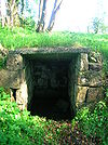
Bird observatory and warden's post.
Marquess of Ailsa
Marquess of Ailsa, of the Isle of Ailsa in the County of Ayr, is a title in the Peerage of the United Kingdom. It was created on 10 September 1831 for Archibald Kennedy, 12th Earl of Cassillis. The title Earl of Cassillis had been created in 1509 for the 3rd Lord Kennedy. This title had been...
and was for many years leased out as a bird sanctuary with a bird observatory and warden's post built and run by the Scottish Society for the Protection of Wild Birds (SSPWB). Common Tern
Common Tern
The Common Tern is a seabird of the tern family Sternidae. This bird has a circumpolar distribution, breeding in temperate and sub-Arctic regions of Europe, Asia and east and central North America. It is strongly migratory, wintering in coastal tropical and subtropical regions. It is sometimes...
s and Arctic Tern
Arctic Tern
The Arctic Tern is a seabird of the tern family Sternidae. This bird has a circumpolar breeding distribution covering the Arctic and sub-Arctic regions of Europe, Asia, and North America...
s used to nest here and Roseate tern
Roseate Tern
The Roseate Tern is a seabird of the tern family Sternidae. This bird has a number of geographical races, differing mainly in bill colour and minor plumage details....
s had been observed on may occasions. The observatory carries a sign saying that it was built In memory of Johnny Warren, honorary warden Lady Isle Sanctuary Troon who died 24 May 1958.
Lady Isle is said to have been Britain's first seabird reserve. The Scottish Natural Heritage
Scottish Natural Heritage
Scottish Natural Heritage is a Scottish public body. It is responsible for Scotland's natural heritage, especially its natural, genetic and scenic diversity. It advises the Scottish Government and acts as a government agent in the delivery of conservation designations, i.e...
has designated the island as a Wild Bird Sanctuary under the Protection of Birds Act 1954 and as an Area of Special Protection, together with Horse island off Ardrossan
Ardrossan
Ardrossan is a town on the North Ayrshire coast in south-western Scotland. The name "Ardrossan" describes its physical position — 'ard' from the Gaelic àird meaning headland, 'ros' a promontory and the diminutive suffix '-an' - headland of the little promontory...
. Scart rock off the island is named from the Scots
Scots language
Scots is the Germanic language variety spoken in Lowland Scotland and parts of Ulster . It is sometimes called Lowland Scots to distinguish it from Scottish Gaelic, the Celtic language variety spoken in most of the western Highlands and in the Hebrides.Since there are no universally accepted...
for a cormorant
Cormorant
The bird family Phalacrocoracidae is represented by some 40 species of cormorants and shags. Several different classifications of the family have been proposed recently, and the number of genera is disputed.- Names :...
. Mr. Donald J. Cameron, was the architect for the SSPWB and he informed their Secretary that there were signs of some sort of ancient ecclesiastical building on the island.
The Freshwater well or spring
A freshwater well or spring lies in a rock cut basin in the middle of the island. This may be entirely natural or partly so, as place name and other evidence suggests that a chapel once existed here and a supply of freshwater would have been essential. Sheep were once grazed here and they would have required a good supply of freshwater, as would the rabbits which still survive (1993). Two elderElderberry
Sambucus is a genus of between 5 and 30 species of shrubs or small trees in the moschatel family, Adoxaceae. It was formerly placed in the honeysuckle family, Caprifoliaceae, but was reclassified due to genetic evidence...
bushes were growing over the well / spring during the 1993 Scottish Wildlife Trust visit.
Trig point
Ordnance Survey
Ordnance Survey , an executive agency and non-ministerial government department of the Government of the United Kingdom, is the national mapping agency for Great Britain, producing maps of Great Britain , and one of the world's largest producers of maps.The name reflects its creation together with...
trig point
Trig point
A triangulation station, also known as a triangulation pillar, trigonometrical station, trigonometrical point, trig station, trig beacon or trig point, and sometimes informally as a trig, is a fixed surveying station, used in geodetic surveying and other surveying projects in its vicinity...
has been placed on the island, just in front of the bird observatory, indicating the 6m height point. This Trig point is a truncated square concrete pyramid, generally known as a Hotine Pillar. On the top is a brass plate with three arms and a central depression is fixed. A benchmark is set on the side, marked with the letters "O S B M" (Ordnance Survey Bench Mark) and the reference number. Within the trig point are concealed mountings for a specialized theodolite, which can be temporarily mounted on the trig point for measurements to be taken.
On 24 September 2000 a small group of Trig point enthusiasts visited the island as part of a quest to visit one trig point of every height in metres in Scotland, making 749 in total.
Shipwrecks
A few ships have come to grief on the island, however the crews were easily rescued. It is said that there are the remains of a great many shipwrecks round the Isle. An old story relates that one of the Spanish ArmadaSpanish Armada
This article refers to the Battle of Gravelines, for the modern navy of Spain, see Spanish NavyThe Spanish Armada was the Spanish fleet that sailed against England under the command of the Duke of Medina Sidonia in 1588, with the intention of overthrowing Elizabeth I of England to stop English...
ships was wrecked here, and sank in deep water. She is said to have been carrying a gold throne on board, a gift to King Phillip of Spain. Troon men made many attempts to bring the Spanish treasures to the surface, but without success.
A professional Dutch diver was supposedly hired to do the salvage job, making his headquarters on the isle, with a store ship standing by. Upon discovering the wreck and entering he found the golden throne, on which was seated, a gigantic figure who rose and came towards him. When the diver grasped the hand of the figure, instead of a hand, he found that he was grasping a cloven hoof! He escaped the scene with his life and some of his wits intact, however no one has attempted further salvage attempts. One of the Masters of a Kilwinning Lodge was presented with a wooden mallet which had been made with wood from one of the Armada ships which had been wrecked on the Ayrshire coast.
Flora and fauna
Eider
Eiders are large seaducks in the genus Somateria. Steller's Eider, despite its name, is in a different genus.The three extant species all breed in the cooler latitudes of the Northern hemisphere....
s nest on the island. Shag
Cormorant
The bird family Phalacrocoracidae is represented by some 40 species of cormorants and shags. Several different classifications of the family have been proposed recently, and the number of genera is disputed.- Names :...
s and oystercatcher
Oystercatcher
The oystercatchers are a group of waders; they form the family Haematopodidae, which has a single genus, Haematopus. They are found on coasts worldwide apart from the polar regions and some tropical regions of Africa and South East Asia...
s are frequently seen. A population of rabbit
Rabbit
Rabbits are small mammals in the family Leporidae of the order Lagomorpha, found in several parts of the world...
s survive with partially collapsed burrows criss-crossing the parts of the islet with have a significant depth of soil. In the Statistical Account of Scotland of 1791,
under the Article on the Parish of Ayr, it confirms that the Isle is inhabited by rabbits. A large number of the common snail, Helix aspersa
Helix aspersa
Helix aspersa, known by the common name garden snail, is a species of land snail, a pulmonate gastropod that is one of the best-known of all terrestrial molluscs. The species has been placed in the genus Helix, in all sources between 1774 and 1988 and in most sources until recently...
species were noted on the 1993 SWT visit. One odd feature of the island was the very large numbers of animal bones, mostly of mammal origin, brought here by the gulls.
Seals are frequently seen on the island and the associated rocks,one of which is called Seal Rock. A Mr. William Allasson of Troon was tenant of the isle in 1811, and he was hindered by the large number of people who landed on the isle, causing damage to his flock of sheep, and stealing the rabbits. Lobsters were plentiful amongst the surrounding rocks and in the past the Duke of Portland went to considerable trouble to try and prevent 'poaching' of the lobster
Lobster
Clawed lobsters comprise a family of large marine crustaceans. Highly prized as seafood, lobsters are economically important, and are often one of the most profitable commodities in coastal areas they populate.Though several groups of crustaceans are known as lobsters, the clawed lobsters are most...
s as he saw it.
Elder
Elderberry
Sambucus is a genus of between 5 and 30 species of shrubs or small trees in the moschatel family, Adoxaceae. It was formerly placed in the honeysuckle family, Caprifoliaceae, but was reclassified due to genetic evidence...
bushes grow near the freshwater spring and sea pink
Armeria
Armeria is the botanical name for a genus of flowering plants. These plants are sometimes known as "thrift" or as the "sea pinks" as they are often found on coastlines...
s are very common. As previously stated, a fire in the 19th-century resulted in the loss of much of the island's soil, the wind blowing it into the sea. The island has been designated site number 8725, an 'Area of Special Protection' by Scottish Natural Heritage
Scottish Natural Heritage
Scottish Natural Heritage is a Scottish public body. It is responsible for Scotland's natural heritage, especially its natural, genetic and scenic diversity. It advises the Scottish Government and acts as a government agent in the delivery of conservation designations, i.e...
.
Smith records Sea Mouse-Ear (Cerastium diffusum), Narrow-leaved Mouse-ear (Cerastium triviale), Sea-Pearlwort (Sagina maritimum), Corn Spurrey (Spergula arvensis), Greater Sea-Spurrey (Spergularia media), Dovesfoot Cranesbill (Geranium molle), Common Stork's-bill (Erodium cicutarium), Common Vetch (Vicia sativa), Bramble (Rubus fruticosus), Common Silverweed (Argentina anserina), Marsh Cinquefoil (Potentilla palustris), and English Stonecrop (Sedum anglicum) for Lady Isle in the 1890s.
The Scottish Wildlife Trust's (SWT) visit
It was proposed that the Scottish Wildlife TrustScottish Wildlife Trust
The Scottish Wildlife Trust is a registered charity dedicated to conserving the wildlife and natural environment of Scotland.-Description:The Scottish Wildlife Trust has over 32,800 members...
might take over the isle as a reserve, however the loss of the terns due to the large colony of herring and other gulls, together with a depletion of the flora, also due to the gulls, led to this proposal being rejected. Members visited the island on 19 May 1993 to assess its value as a reserve, taking the boat from Troon
Troon
Troon is a town in South Ayrshire. It is situated on the west coast of Scotland, about eight miles north of Ayr and three miles northwest of Glasgow Prestwick International Airport. Lying across the Firth of Clyde, the Isle of Arran can be seen. Troon is also a port with freight and ferry services...
harbour which regularly visits the island to maintain the lighthouse.