
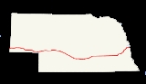
Interstate 80 in Nebraska
Encyclopedia
In the U.S. state
of Nebraska
, Interstate 80
runs west from Omaha
to the Wyoming
state border, ultimately terminating in San Francisco, California
. When it completed construction of the stretch of Interstate 80 spanning the state on October 19, 1974, Nebraska was the first state in the nation to complete its mainline Interstate Highway System.
Nebraska has more than fifty exits along Interstate 80. According to the New York Times there are several notable tourist attraction
s along Nebraska's section of I-80. It is the only interstate highway to go from one end of the state to another, as Nebraska has no major north-south interstate route. Except for a three mile portion of Interstate 76
near the Colorado
state line, I-80 is the only primary (two-digit) Interstate Highway in Nebraska.
, I-80 in Nebraska follows the same route as many historic trails, including the Oregon Trail
, the California Trail
and the Mormon Trail
. Starting in 1957 after federal funding was allotted, Nebraskans began planning their interstate construction. Led by the Nebraska State Highway Commission, there were hearings
across the state to decide where the route was going to be. Aside from the federally-mandated "control points" in Omaha and Scottsbluff
, the route could vary across the state. Dozens of meetings were held in Grand Island
, Kearney
and North Platte
, among other locations. The commission addressed issues of whether the highway would be north or south of the Platte River
or whether it would follow U.S. 30. The South Platte Chamber of Commerce and various cities were very active in these sessions, and debate over where the Interstate would be constructed continued into the 1960s.
After the first contract for building the interstate was awarded in 1957, a 6.5 miles (10.5 km) section near Gretna
was the first section to be completed that year. The first long segment to be opened was a fifty mile section between Dodge Street in Omaha
and the West Lincoln interchange in Lincoln
in 1961. During a "Golden Link" ceremony, the last section of I-80 in Nebraska was completed when a brass
connector was inserted in the roadway near Sidney
on April 1, 1974. This was designed to keep in tradition with the golden spike
on the railroads in 1869.
The total length of the Nebraska section is 455.27 miles (732.7 km) long, and was completed at a cost of $435 million.
The Interstate passes through 15 counties in the state: Kimball
, Cheyenne
, Deuel
, Keith
, Lincoln
, Dawson
, Buffalo
, Hall
, Hamilton
, York
, Seward
, Lancaster
, Cass
, Sarpy
, and Douglas
.
 The entirety of the Interstate Highway System
was named the "Dwight D. Eisenhower System of Interstate and Defense Highways" in 1990, and the first signage in Nebraska was posted in 1993. Several sections of I-80 in Nebraska have special designations. The I-80 intersection with US-34 has been designated a "Purple Heart
Memorial Highway", and South 108th Street bridge over I-80 in Omaha has been designated the "Purple Heart Bridge", both in honor of all recipients of the Purple Heart. A section of I-80 in Nebraska is also designated as a Blue Star Memorial Highway
.
to split the Department of Roads and Irrigation in order to create three separate agencies in the state, including the Department of Motor Vehicles, Department of Water Resources and the Department of Roads, which was the first Nebraska agency solely responsible for highway planning, construction, and maintenance in Nebraska history.
Interstate construction led the state to focus on other highways in Nebraska, as well. Surfaced shoulders
, new safety sections beyond shoulders and other developments across the state were attributed to the influence of the Interstate. The 1965 state Legislature also authorized a study of the needs of every public road in Nebraska, including state highways, county roads, and city streets.
s, 442 bridge
s are on or over the roadway and 25 rest area
s and one scenic overlook, each spaced 35-50 miles apart for convenience. The I-80 rights-of-way in Nebraska feature 28 types of grass
es and forb
s, 31 types of shrub
s, 12 varieties of coniferous trees, and 39 types of deciduous trees are planted on the median of I-80 in Nebraska. There are also 570 informational and directional signs along the way.
s that have existed on I-80 in Nebraska since it was opened in 1957.
!County
!Location
!Mile
!#
!Destinations
!Notes
|-
|rowspan=5|Kimball
|
|0.48
|1
| - Pine Bluffs
|
|-
|
|8.46
|8
|
|
|-
|
|20.70
|20
|
|
|-
|
|22.69
|22
|Kimball
(L-53E)
|
|-
|
|29.76
|29
|
|
|-
|rowspan=6|Cheyenne
|
|38.96
|38
|
|
|-
|
|48.92
|48
|
|
|-
|
|55.37
|55
|
|
|-
|Sidney
|59.92
|59
|
|
|-
|
|69.63
|69
|
|
|-
|
|76.61
|76
|
|
|-
|rowspan=5|Deuel
|
|85.22
|85
|
|
|-
|
|95.02
|95
| - Julesburg, Oshkosh
|
|-
|
|101.19
|101
|, Julesburg
|
|-
|
|102.59
|102
| – Denver
|
|-
|
|107.36
|107
|
|
|-
|rowspan=4|Keith
|
|117.25
|117
|
|
|-
|Ogallala
|126.69
|126
|
|
|-
|
|133.96
|133
|
|
|-
|
|145.65
|145
|
|
|-
|rowspan=6|Lincoln
|
|158.01
|158
|
|
|-
|
|164.52
|164
|
|
|-
|rowspan=2|North Platte
|177.16
|177
|
|
|-
|179.22
|179
|
|
|-
|
|190.45
|190
|
|
|-
|
|198.98
|199
|
|
|-
|rowspan=5|Dawson
|Gothenburg
|211.79
|211
|
|
|-
|Cozad
|222.46
|222
|
|
|-
|
|231.10
|231
|
|
|-
|
|237.20
|237
|
|
|-
|
|248.53
|248
|
|
|-
|rowspan=6|Buffalo
|
|257.00
|257
|
|
|-
|
|263.67
|263
|
|
|-
|Kearney
|272.60
|272
|, Archway Monument
|
|-
|
|279.90
|279
|
|
|-
|
|285.63
|285
|
|
|-
|
|291.36
|291
|
|
|-
|rowspan=4|Hall
|
|300.10
|300
|
|
|-
|
|305.66
|305
|
|
|-
|rowspan=3|Grand Island
|312.07
|312
|
|
|-
|314.11
|314
|Locust Street – Grand Island
|
|-
|rowspan=4|Hamilton
|318.16
|318
|
|
|-
|
|324.16
|324
|
|
|-
|
|332.17
|332
|
|
|-
|
|338.14
|338
|
|
|-
|rowspan=4|York
|
|342.13
|342
|
|
|-
|
|348.11
|348
|
|
|-
|York
|353.10
|353
|
|
|-
|
|360.13
|360
|
|
|-
|rowspan=6|Seward
|
|366.15
|366
|
|
|-
|
|369.14
|369
|
|
|-
|
|373.11
|373
|
|
|-
|
|379.11
|379
|
|
|-
|
|382.11
|382
|Milford
(L-80H)
|
|-
|
|388.13
|388
|
|
|-
|rowspan=8|Lancaster
|rowspan=6|Lincoln
|395.61
|395
|
|
|-
|396.36
|396
|
|Westbound exit is via exit 397
|-
|397.27
|397
|
|West end of US 77 overlap
|-
|399.03
|399
|Lincoln Municipal Airport
|
|-
|401.04
|401
|
|Signed as exits 401A (south/east) and 401B (west)
|-
|403.49
|403
|27th Street – State Fair Park
|
|-
|
|405.76
|405
|
|East end of US 77 overlap
|-
|
|409.76
|409
|
|
|-
|rowspan=2|Cass
|
|420.94
|420
|
|
|-
|
|426.07
|426
| – Mahoney State Park, Ashland, South Bend
|Strategic Air and Space Museum
|-
|rowspan=4|Sarpy
|
|432.95
|432
|
|
|-
|
|439.20
|439
|
|Werner Park (stadium), Offutt Air Force Base
|-
|
|440.65
|440
|
|
|-
|
|442.90
|442
|Giles Road, Harrison Street
|
|-
|rowspan=11|Douglas
|rowspan=11|Omaha
|
|444
|Q Street
|Westbound exit only
|-
|445.05
|445
|
|
|-
|
|445
|I Street
|Westbound exit and eastbound entrance
|-
|445.98
|446
|
|
|-
|448.30
|448
|84th Street
|
|-
|449.31
|449
|72nd Street
|
|-
|450.32
|450
|60th Street
|
|-
|451.84
|451
|42nd Street
|
|-
|452.86
|452
|
|Eppley Airfield (north), Bellevue
(south)
|-
|453.05
|453
|24th Street
|Eastbound exit and westbound entrance
|-
|454.15
|454
|13th Street
|
 - Interstate 480
is a 4.9 miles (7.9 km) loop route in Omaha extending from Interstate 29
in Council Bluffs west towards I-80. It serves as the inner of two loops in Omaha. Signed as US 6
for a mile across the Missouri River, when the Interstate meets with the North Freeway and turns south it becomes US 75
.
 - Interstate 680
is a 42.86 miles (69 km) loop around the city of Omaha. It serves as the outer of the two Omaha loops.
 - Interstate 180
is a 3.47 miles (5.6 km) spur into the city of Lincoln.
U.S. state
A U.S. state is any one of the 50 federated states of the United States of America that share sovereignty with the federal government. Because of this shared sovereignty, an American is a citizen both of the federal entity and of his or her state of domicile. Four states use the official title of...
of Nebraska
Nebraska
Nebraska is a state on the Great Plains of the Midwestern United States. The state's capital is Lincoln and its largest city is Omaha, on the Missouri River....
, Interstate 80
Interstate 80
Interstate 80 is the second-longest Interstate Highway in the United States, following Interstate 90. It is a transcontinental artery running from downtown San Francisco, California to Teaneck, New Jersey in the New York City Metropolitan Area...
runs west from Omaha
Omaha
Omaha may refer to:*Omaha , a Native American tribe that currently resides in the northeastern part of the U.S. state of Nebraska-Places:United States* Omaha, Nebraska* Omaha, Arkansas* Omaha, Georgia* Omaha, Illinois* Omaha, Texas...
to the Wyoming
Wyoming
Wyoming is a state in the mountain region of the Western United States. The western two thirds of the state is covered mostly with the mountain ranges and rangelands in the foothills of the Eastern Rocky Mountains, while the eastern third of the state is high elevation prairie known as the High...
state border, ultimately terminating in San Francisco, California
San Francisco, California
San Francisco , officially the City and County of San Francisco, is the financial, cultural, and transportation center of the San Francisco Bay Area, a region of 7.15 million people which includes San Jose and Oakland...
. When it completed construction of the stretch of Interstate 80 spanning the state on October 19, 1974, Nebraska was the first state in the nation to complete its mainline Interstate Highway System.
Nebraska has more than fifty exits along Interstate 80. According to the New York Times there are several notable tourist attraction
Tourist attraction
A tourist attraction is a place of interest where tourists visit, typically for its inherent or exhibited cultural value, historical significance, natural or built beauty, or amusement opportunities....
s along Nebraska's section of I-80. It is the only interstate highway to go from one end of the state to another, as Nebraska has no major north-south interstate route. Except for a three mile portion of Interstate 76
Interstate 76
Interstate 76 may refer to:* Interstate 76 , an Interstate Highway in the United States, running through New Jersey, Pennsylvania, and Ohio* Interstate 76 , an Interstate Highway in the United States, running through Nebraska and Colorado...
near the Colorado
Colorado
Colorado is a U.S. state that encompasses much of the Rocky Mountains as well as the northeastern portion of the Colorado Plateau and the western edge of the Great Plains...
state line, I-80 is the only primary (two-digit) Interstate Highway in Nebraska.
History
Built along the pathway of the Great Platte River RoadGreat Platte River Road
The Great Platte River Road was the convergence point for the Trapper's Trail, the Oregon Trail, the Mormon Trail, the California Trail, the Pony Express route, and the military road from Fort Leavenworth to Fort Laramie across Nebraska. The Road, which extended from the Second Fort Kearny to Fort...
, I-80 in Nebraska follows the same route as many historic trails, including the Oregon Trail
Oregon Trail
The Oregon Trail is a historic east-west wagon route that connected the Missouri River to valleys in Oregon and locations in between.After 1840 steam-powered riverboats and steamboats traversing up and down the Ohio, Mississippi and Missouri rivers sped settlement and development in the flat...
, the California Trail
California Trail
The California Trail was an emigrant trail of about across the western half of the North American continent from Missouri River towns to what is now the state of California...
and the Mormon Trail
Mormon Trail
The Mormon Trail or Mormon Pioneer Trail is the 1,300 mile route that members of The Church of Jesus Christ of Latter-day Saints traveled from 1846 to 1868...
. Starting in 1957 after federal funding was allotted, Nebraskans began planning their interstate construction. Led by the Nebraska State Highway Commission, there were hearings
Hearing (law)
In law, a hearing is a proceeding before a court or other decision-making body or officer, such as a government agency.A hearing is generally distinguished from a trial in that it is usually shorter and often less formal...
across the state to decide where the route was going to be. Aside from the federally-mandated "control points" in Omaha and Scottsbluff
Scottsbluff, Nebraska
Scottsbluff is a city in Scotts Bluff County, Nebraska, United States. The population was 15,039 at the 2010 census. Scottsbluff is the largest city in the Nebraska Panhandle, and the 13th largest city in Nebraska....
, the route could vary across the state. Dozens of meetings were held in Grand Island
Grand Island, Nebraska
Grand Island is a city in and the county seat of Hall County, Nebraska, United States. The population was 48,520 at the 2010 census.Grand Island is home to the Nebraska Law Enforcement Training Center which is the sole agency responsible for training law enforcement officers throughout the state,...
, Kearney
Kearney, Nebraska
Kearney is a city in and the county seat of Buffalo County, Nebraska, United States. The population was 30,787 at the 2010 census. It is home to the University of Nebraska-Kearney....
and North Platte
North Platte, Nebraska
North Platte is a city in and the county seat of Lincoln County, Nebraska, United States. It is located in the southwestern part of the state, along Interstate 80, at the confluence of the North and South Platte Rivers forming the Platte River...
, among other locations. The commission addressed issues of whether the highway would be north or south of the Platte River
Platte River
The Platte River is a major river in the state of Nebraska and is about long. Measured to its farthest source via its tributary the North Platte River, it flows for over . The Platte River is a tributary of the Missouri River, which in turn is a tributary of the Mississippi River which flows to...
or whether it would follow U.S. 30. The South Platte Chamber of Commerce and various cities were very active in these sessions, and debate over where the Interstate would be constructed continued into the 1960s.
After the first contract for building the interstate was awarded in 1957, a 6.5 miles (10.5 km) section near Gretna
Gretna, Nebraska
Gretna is a city in Sarpy County, Nebraska, United States. The population was 2,355 at the 2000 census. In 2008, its population was estimated to be 6,572. Gretna has the fastest rate of growth of any Nebraska city since 2000.-History:...
was the first section to be completed that year. The first long segment to be opened was a fifty mile section between Dodge Street in Omaha
Omaha
Omaha may refer to:*Omaha , a Native American tribe that currently resides in the northeastern part of the U.S. state of Nebraska-Places:United States* Omaha, Nebraska* Omaha, Arkansas* Omaha, Georgia* Omaha, Illinois* Omaha, Texas...
and the West Lincoln interchange in Lincoln
Lincoln, Nebraska
The City of Lincoln is the capital and the second-most populous city of the US state of Nebraska. Lincoln is also the county seat of Lancaster County and the home of the University of Nebraska. Lincoln's 2010 Census population was 258,379....
in 1961. During a "Golden Link" ceremony, the last section of I-80 in Nebraska was completed when a brass
Brass
Brass is an alloy of copper and zinc; the proportions of zinc and copper can be varied to create a range of brasses with varying properties.In comparison, bronze is principally an alloy of copper and tin...
connector was inserted in the roadway near Sidney
Sidney, Nebraska
Sidney is a city in Cheyenne County, Nebraska, United States. The population was 6,282 at the 2000 census. It is the county seat of Cheyenne County.-History:The city was named for Sidney Dillon, a railroad attorney...
on April 1, 1974. This was designed to keep in tradition with the golden spike
Golden spike
The "Golden Spike" is the ceremonial final spike driven by Leland Stanford to join the rails of the First Transcontinental Railroad across the United States connecting the Central Pacific and Union Pacific railroads on May 10, 1869, at Promontory Summit, Utah Territory...
on the railroads in 1869.
The total length of the Nebraska section is 455.27 miles (732.7 km) long, and was completed at a cost of $435 million.
The Interstate passes through 15 counties in the state: Kimball
Kimball County, Nebraska
-History:Kimball County was formed in 1888. It was named after railroad pioneer Thomas L. Kimball.-Demographics:As of the census of 2000, there were 4,089 people, 1,727 households, and 1,136 families residing in the county. The population density was 4 people per square mile . There were 1,972...
, Cheyenne
Cheyenne County, Nebraska
-History:Cheyenne County was formed in 1871. It was named after the Cheyenne Native American tribe.-Demographics:As of the census of 2000, of 2000, there were 9,830 people, 4,071 households, and 2,686 families residing in the county. The population density was 8 people per square mile . There...
, Deuel
Deuel County, Nebraska
-History:Deuel County was formed in 1889. It was named after Harry Porter Deuel, an early pioneer in this area.-Demographics:As of the census of 2000, there were 2,098 people, 908 households, and 601 families residing in the county. The population density was 5 people per square mile . There were...
, Keith
Keith County, Nebraska
-History:Keith County was formed in 1873. It was named after Morrill C. Keith, the grandfather of Governor Keith Neville.-Demographics:As of the census of 2000, there were 8,875 people, 3,707 households, and 2,535 families residing in the county. The population density was 8 people per square mile...
, Lincoln
Lincoln County, Nebraska
-Demographics:As of the census of 2000, there were 34,632 people, 14,076 households, and 9,444 families residing in the county. The population density was 14 people per square mile . There are 15,438 housing units in Lincoln....
, Dawson
Dawson County, Nebraska
Dawson County is a county located in the U.S. state of Nebraska. As of 2010, the population was 24,326. Its county seat is Lexington.Dawson County is part of the Lexington, Nebraska, Micropolitan Statistical Area....
, Buffalo
Buffalo County, Nebraska
-Demographics:As of the census of 2000, there were 42,259 people, 15,930 households, and 10,227 families residing in the county. The population density was 44 people per square mile . There were 16,830 housing units at an average density of 17 per square mile...
, Hall
Hall County, Nebraska
-History:Hall County was formed in 1858. It was named after Augustus Hall, an early judge of this territory.- Demographics :As of the census of 2000, there were 53,534 people, 20,356 households, and 14,086 families residing in the county. The population density was 98 people per square mile...
, Hamilton
Hamilton County, Nebraska
-Demographics:As of the census of 2000, there were 9,403 people, 3,503 households, and 2,676 families residing in the county. The population density was 17 people per square mile . There were 3,850 housing units at an average density of 7 per square mile...
, York
York County, Nebraska
-History:York County was formed in 1855. It was either named after the city York in England or for York County in Pennsylvania.-Demographics:As of the census of 2000, there were 14,598 people, 5,722 households, and 3,931 families residing in the county. The population density was 25 people per...
, Seward
Seward County, Nebraska
-Demographics:As of the census of 2000, there were 16,496 people, 6,013 households, and 4,215 families residing in the county. The population density was 29 people per square mile . There were 6,428 housing units at an average density of 11 per square mile...
, Lancaster
Lancaster County, Nebraska
-Demographics:As of the census of 2000, there were 250,291 people, 99,187 households, and 60,702 families residing in the county. The population density was 298 people per square mile . There were 104,217 housing units at an average density of 124 per square mile...
, Cass
Cass County, Nebraska
-Other Geographical notes:Due to its proximity to Cass County, Iowa, and because both of those counties receive most of their broadcasts from Omaha, Nebraska, references to 'Cass County' must be frequently disambiguated, or result in confusion.-Demographics:...
, Sarpy
Sarpy County, Nebraska
-Demographics:As of the census of 2000, there were 122,595 people, 43,426 households, and 33,220 families residing in the county. The population density was 510 people per square mile . There were 44,981 housing units at an average density of 187 per square mile...
, and Douglas
Douglas County, Nebraska
-Demographics:As of the census of 2000, there were 463,585 people, 182,194 households, and 115,146 families residing in the county. The population density was 1,401 people per square mile . There were 192,672 housing units at an average density of 582 per square mile...
.
Designated sections
Interstate Highway System
The Dwight D. Eisenhower National System of Interstate and Defense Highways, , is a network of limited-access roads including freeways, highways, and expressways forming part of the National Highway System of the United States of America...
was named the "Dwight D. Eisenhower System of Interstate and Defense Highways" in 1990, and the first signage in Nebraska was posted in 1993. Several sections of I-80 in Nebraska have special designations. The I-80 intersection with US-34 has been designated a "Purple Heart
Purple Heart
The Purple Heart is a United States military decoration awarded in the name of the President to those who have been wounded or killed while serving on or after April 5, 1917 with the U.S. military. The National Purple Heart Hall of Honor is located in New Windsor, New York...
Memorial Highway", and South 108th Street bridge over I-80 in Omaha has been designated the "Purple Heart Bridge", both in honor of all recipients of the Purple Heart. A section of I-80 in Nebraska is also designated as a Blue Star Memorial Highway
Blue Star Memorial Highway
Blue Star Memorial Highways are highways in the United States that are marked to pay tribute to the U.S. armed forces. The National Council of State Garden Clubs, now known as National Garden Clubs, Inc., started the program in 1945 after World War II. The blue star was used on service flags to...
.
Legacy
The beginning of the I-80 construction in Nebraska in 1957 led the Nebraska LegislatureNebraska Legislature
The Nebraska Legislature is the supreme legislative body of the State of Nebraska, in the Great Plains region of the United States. The Legislature meets at the Nebraska State Capitol in the City of Lincoln, Lancaster County....
to split the Department of Roads and Irrigation in order to create three separate agencies in the state, including the Department of Motor Vehicles, Department of Water Resources and the Department of Roads, which was the first Nebraska agency solely responsible for highway planning, construction, and maintenance in Nebraska history.
Interstate construction led the state to focus on other highways in Nebraska, as well. Surfaced shoulders
Shoulder (road)
A hard shoulder, or simply shoulder, is a reserved area by the verge of a road or motorway. Generally it is kept clear of motor vehicle traffic...
, new safety sections beyond shoulders and other developments across the state were attributed to the influence of the Interstate. The 1965 state Legislature also authorized a study of the needs of every public road in Nebraska, including state highways, county roads, and city streets.
Details
In Nebraska, I-80 has 82 interchangeInterchange (road)
In the field of road transport, an interchange is a road junction that typically uses grade separation, and one or more ramps, to permit traffic on at least one highway to pass through the junction without directly crossing any other traffic stream. It differs from a standard intersection, at which...
s, 442 bridge
Bridge
A bridge is a structure built to span physical obstacles such as a body of water, valley, or road, for the purpose of providing passage over the obstacle...
s are on or over the roadway and 25 rest area
Rest area
A rest area, travel plaza, rest stop, or service area is a public facility, located next to a large thoroughfare such as a highway, expressway, or freeway at which drivers and passengers can rest, eat, or refuel without exiting on to secondary roads...
s and one scenic overlook, each spaced 35-50 miles apart for convenience. The I-80 rights-of-way in Nebraska feature 28 types of grass
Grass
Grasses, or more technically graminoids, are monocotyledonous, usually herbaceous plants with narrow leaves growing from the base. They include the "true grasses", of the Poaceae family, as well as the sedges and the rushes . The true grasses include cereals, bamboo and the grasses of lawns ...
es and forb
Forb
A forb is a herbaceous flowering plant that is not a graminoid . The term is used in biology and in vegetation ecology, especially in relation to grasslands and understory.-Etymology:...
s, 31 types of shrub
Shrub
A shrub or bush is distinguished from a tree by its multiple stems and shorter height, usually under 5–6 m tall. A large number of plants may become either shrubs or trees, depending on the growing conditions they experience...
s, 12 varieties of coniferous trees, and 39 types of deciduous trees are planted on the median of I-80 in Nebraska. There are also 570 informational and directional signs along the way.
Speeds
The following are speed limitSpeed limit
Road speed limits are used in most countries to regulate the speed of road vehicles. Speed limits may define maximum , minimum or no speed limit and are normally indicated using a traffic sign...
s that have existed on I-80 in Nebraska since it was opened in 1957.
| Speed limits on I-80 in Nebraska | |
|---|---|
| Year | Speed limit(s) |
| 1960 | 70 mi/h on the rural interstate. |
| 1964 | 75 mi/h for cars and 65 mi/h for trucks in rural areas. |
| 1980 | 55 mi/h national speed limit, effective December 31, 1980. |
| 1987 | 65 mi/h on the rural interstate. |
| 1995 | 75 mi/h on the rural interstate. |
Exit list
{|class="wikitable"!County
!Location
!Mile
!#
Exit number
An exit number is a number assigned to a road junction, usually an exit from a freeway. It is usually marked on the same sign as the destinations of the exit, as well as a sign in the gore....
!Destinations
!Notes
|-
|rowspan=5|Kimball
Kimball County, Nebraska
-History:Kimball County was formed in 1888. It was named after railroad pioneer Thomas L. Kimball.-Demographics:As of the census of 2000, there were 4,089 people, 1,727 households, and 1,136 families residing in the county. The population density was 4 people per square mile . There were 1,972...
|
|0.48
|1
| - Pine Bluffs
|
|-
|
|8.46
|8
|
|
|-
|
|20.70
|20
|
|
|-
|
|22.69
|22
|Kimball
Kimball, Nebraska
Kimball is a city in Kimball County, Nebraska, United States. The population was 2,559 at the 2000 census. It is the county seat of Kimball County.-Geography:Kimball is located at , in the southwestern Panhandle....
(L-53E)
|
|-
|
|29.76
|29
|
|
|-
|rowspan=6|Cheyenne
Cheyenne County, Nebraska
-History:Cheyenne County was formed in 1871. It was named after the Cheyenne Native American tribe.-Demographics:As of the census of 2000, of 2000, there were 9,830 people, 4,071 households, and 2,686 families residing in the county. The population density was 8 people per square mile . There...
|
|38.96
|38
|
|
|-
|
|48.92
|48
|
|
|-
|
|55.37
|55
|
|
|-
|Sidney
Sidney, Nebraska
Sidney is a city in Cheyenne County, Nebraska, United States. The population was 6,282 at the 2000 census. It is the county seat of Cheyenne County.-History:The city was named for Sidney Dillon, a railroad attorney...
|59.92
|59
|
|
|-
|
|69.63
|69
|
|
|-
|
|76.61
|76
|
|
|-
|rowspan=5|Deuel
Deuel County, Nebraska
-History:Deuel County was formed in 1889. It was named after Harry Porter Deuel, an early pioneer in this area.-Demographics:As of the census of 2000, there were 2,098 people, 908 households, and 601 families residing in the county. The population density was 5 people per square mile . There were...
|
|85.22
|85
|
|
|-
|
|95.02
|95
| - Julesburg, Oshkosh
|
|-
|
|101.19
|101
|, Julesburg
|
|-
|
|102.59
|102
| – Denver
Denver, Colorado
The City and County of Denver is the capital and the most populous city of the U.S. state of Colorado. Denver is a consolidated city-county, located in the South Platte River Valley on the western edge of the High Plains just east of the Front Range of the Rocky Mountains...
|
|-
|
|107.36
|107
|
|
|-
|rowspan=4|Keith
Keith County, Nebraska
-History:Keith County was formed in 1873. It was named after Morrill C. Keith, the grandfather of Governor Keith Neville.-Demographics:As of the census of 2000, there were 8,875 people, 3,707 households, and 2,535 families residing in the county. The population density was 8 people per square mile...
|
|117.25
|117
|
|
|-
|Ogallala
Ogallala, Nebraska
Ogallala is a city in Keith County, Nebraska, United States. The population was 4,737 at the 2010 census. It is the county seat of Keith County. In the days of the Nebraska Territory, the city was a stop on the Pony Express and later along the transcontinental railroad...
|126.69
|126
|
|
|-
|
|133.96
|133
|
|
|-
|
|145.65
|145
|
|
|-
|rowspan=6|Lincoln
Lincoln County, Nebraska
-Demographics:As of the census of 2000, there were 34,632 people, 14,076 households, and 9,444 families residing in the county. The population density was 14 people per square mile . There are 15,438 housing units in Lincoln....
|
|158.01
|158
|
|
|-
|
|164.52
|164
|
|
|-
|rowspan=2|North Platte
North Platte, Nebraska
North Platte is a city in and the county seat of Lincoln County, Nebraska, United States. It is located in the southwestern part of the state, along Interstate 80, at the confluence of the North and South Platte Rivers forming the Platte River...
|177.16
|177
|
|
|-
|179.22
|179
|
|
|-
|
|190.45
|190
|
|
|-
|
|198.98
|199
|
|
|-
|rowspan=5|Dawson
Dawson County, Nebraska
Dawson County is a county located in the U.S. state of Nebraska. As of 2010, the population was 24,326. Its county seat is Lexington.Dawson County is part of the Lexington, Nebraska, Micropolitan Statistical Area....
|Gothenburg
|211.79
|211
|
|
|-
|Cozad
|222.46
|222
|
|
|-
|
|231.10
|231
|
|
|-
|
|237.20
|237
|
|
|-
|
|248.53
|248
|
|
|-
|rowspan=6|Buffalo
Buffalo County, Nebraska
-Demographics:As of the census of 2000, there were 42,259 people, 15,930 households, and 10,227 families residing in the county. The population density was 44 people per square mile . There were 16,830 housing units at an average density of 17 per square mile...
|
|257.00
|257
|
|
|-
|
|263.67
|263
|
|
|-
|Kearney
Kearney, Nebraska
Kearney is a city in and the county seat of Buffalo County, Nebraska, United States. The population was 30,787 at the 2010 census. It is home to the University of Nebraska-Kearney....
|272.60
|272
|, Archway Monument
|
|-
|
|279.90
|279
|
|
|-
|
|285.63
|285
|
|
|-
|
|291.36
|291
|
|
|-
|rowspan=4|Hall
Hall County, Nebraska
-History:Hall County was formed in 1858. It was named after Augustus Hall, an early judge of this territory.- Demographics :As of the census of 2000, there were 53,534 people, 20,356 households, and 14,086 families residing in the county. The population density was 98 people per square mile...
|
|300.10
|300
|
|
|-
|
|305.66
|305
|
|
|-
|rowspan=3|Grand Island
Grand Island, Nebraska
Grand Island is a city in and the county seat of Hall County, Nebraska, United States. The population was 48,520 at the 2010 census.Grand Island is home to the Nebraska Law Enforcement Training Center which is the sole agency responsible for training law enforcement officers throughout the state,...
|312.07
|312
|
|
|-
|314.11
|314
|Locust Street – Grand Island
Grand Island, Nebraska
Grand Island is a city in and the county seat of Hall County, Nebraska, United States. The population was 48,520 at the 2010 census.Grand Island is home to the Nebraska Law Enforcement Training Center which is the sole agency responsible for training law enforcement officers throughout the state,...
|
|-
|rowspan=4|Hamilton
Hamilton County, Nebraska
-Demographics:As of the census of 2000, there were 9,403 people, 3,503 households, and 2,676 families residing in the county. The population density was 17 people per square mile . There were 3,850 housing units at an average density of 7 per square mile...
|318.16
|318
|
|
|-
|
|324.16
|324
|
|
|-
|
|332.17
|332
|
|
|-
|
|338.14
|338
|
|
|-
|rowspan=4|York
York County, Nebraska
-History:York County was formed in 1855. It was either named after the city York in England or for York County in Pennsylvania.-Demographics:As of the census of 2000, there were 14,598 people, 5,722 households, and 3,931 families residing in the county. The population density was 25 people per...
|
|342.13
|342
|
|
|-
|
|348.11
|348
|
|
|-
|York
York, Nebraska
York is a city in York County, Nebraska, in the United States. As of the 2010 census, the city population was 7,766. It is the county seat of York County. It is the home of York College and the Nebraska Correctional Center for Women.-Geography:...
|353.10
|353
|
|
|-
|
|360.13
|360
|
|
|-
|rowspan=6|Seward
Seward County, Nebraska
-Demographics:As of the census of 2000, there were 16,496 people, 6,013 households, and 4,215 families residing in the county. The population density was 29 people per square mile . There were 6,428 housing units at an average density of 11 per square mile...
|
|366.15
|366
|
|
|-
|
|369.14
|369
|
|
|-
|
|373.11
|373
|
|
|-
|
|379.11
|379
|
|
|-
|
|382.11
|382
|Milford
Milford, Nebraska
Milford is a city in Seward County, Nebraska, United States. It is part of the Lincoln, Nebraska Metropolitan Statistical Area. The population was 2,070 at the 2000 census.-Geography:Milford is located at ....
(L-80H)
|
|-
|
|388.13
|388
|
|
|-
|rowspan=8|Lancaster
Lancaster County, Nebraska
-Demographics:As of the census of 2000, there were 250,291 people, 99,187 households, and 60,702 families residing in the county. The population density was 298 people per square mile . There were 104,217 housing units at an average density of 124 per square mile...
|rowspan=6|Lincoln
|395.61
|395
|
|
|-
|396.36
|396
|
|Westbound exit is via exit 397
|-
|397.27
|397
|
|West end of US 77 overlap
|-
|399.03
|399
|Lincoln Municipal Airport
|
|-
|401.04
|401
|
|Signed as exits 401A (south/east) and 401B (west)
|-
|403.49
|403
|27th Street – State Fair Park
|
|-
|
|405.76
|405
|
|East end of US 77 overlap
|-
|
|409.76
|409
|
|
|-
|rowspan=2|Cass
Cass County, Nebraska
-Other Geographical notes:Due to its proximity to Cass County, Iowa, and because both of those counties receive most of their broadcasts from Omaha, Nebraska, references to 'Cass County' must be frequently disambiguated, or result in confusion.-Demographics:...
|
|420.94
|420
|
|
|-
|
|426.07
|426
| – Mahoney State Park, Ashland, South Bend
|Strategic Air and Space Museum
Strategic Air and Space Museum
The Strategic Air and Space Museum is a museum focusing on United States Air Force military aircraft and nuclear missiles located near Ashland, Nebraska, along Interstate 80 southwest of Omaha, Nebraska. The objective of the museum is to preserve and display historic aircraft, missile, and space...
|-
|rowspan=4|Sarpy
Sarpy County, Nebraska
-Demographics:As of the census of 2000, there were 122,595 people, 43,426 households, and 33,220 families residing in the county. The population density was 510 people per square mile . There were 44,981 housing units at an average density of 187 per square mile...
|
|432.95
|432
|
|
|-
|
|439.20
|439
|
|Werner Park (stadium), Offutt Air Force Base
Offutt Air Force Base
Offutt Air Force Base is a U.S. Air Force installation near Omaha, and lies adjacent to Bellevue in Sarpy County, Nebraska. It is the headquarters of the U.S...
|-
|
|440.65
|440
|
|
|-
|
|442.90
|442
|Giles Road, Harrison Street
|
|-
|rowspan=11|Douglas
Douglas County, Nebraska
-Demographics:As of the census of 2000, there were 463,585 people, 182,194 households, and 115,146 families residing in the county. The population density was 1,401 people per square mile . There were 192,672 housing units at an average density of 582 per square mile...
|rowspan=11|Omaha
Omaha, Nebraska
Omaha is the largest city in the state of Nebraska, United States, and is the county seat of Douglas County. It is located in the Midwestern United States on the Missouri River, about 20 miles north of the mouth of the Platte River...
|
|444
|Q Street
|Westbound exit only
|-
|445.05
|445
|
|
|-
|
|445
|I Street
|Westbound exit and eastbound entrance
|-
|445.98
|446
|
|
|-
|448.30
|448
|84th Street
|
|-
|449.31
|449
|72nd Street
|
|-
|450.32
|450
|60th Street
|
|-
|451.84
|451
|42nd Street
|
|-
|452.86
|452
|
|Eppley Airfield (north), Bellevue
Bellevue, Nebraska
Bellevue is a city in Sarpy County, Nebraska, United States. The population was 50,137 at the 2010 census. Eight miles south of Omaha, Bellevue is part of the Omaha-Council Bluffs metropolitan area. Originally settled in the 1830s, It was the first state capitol. Bellevue was incorporated in...
(south)
|-
|453.05
|453
|24th Street
|Eastbound exit and westbound entrance
|-
|454.15
|454
|13th Street
|
Auxiliary routes
Interstate 80 has three auxiliary routes in Nebraska. One is a loop around the city of Omaha, one is a loop through the city of Omaha, and the other is a spur into Lincoln. - Interstate 480Interstate 480 (Iowa-Nebraska)
Interstate 480 is an auxiliary Interstate Highway, a mere long, that connects Interstate 80 in downtown Omaha, Nebraska, with Interstate 29 in Council Bluffs, Iowa. The portion of I-480 in Nebraska has been named the Gerald R. Ford Freeway, named in honor of the former President, who was a...
is a 4.9 miles (7.9 km) loop route in Omaha extending from Interstate 29
Interstate 29
Interstate 29 is an Interstate Highway in the Midwestern United States. I-29 runs from Kansas City, Missouri, at a junction with Interstate 35 and Interstate 70 to the Canadian border near Pembina, North Dakota, where it connects with Manitoba Highway 75 via the short Manitoba Highway 29.-Route...
in Council Bluffs west towards I-80. It serves as the inner of two loops in Omaha. Signed as US 6
U.S. Route 6
U.S. Route 6 , also called the Grand Army of the Republic Highway, a name that honors an American Civil War veterans association, is a main route of the U.S. Highway system, running east-northeast from Bishop, California to Provincetown, Massachusetts. Until 1964, it continued south from Bishop to...
for a mile across the Missouri River, when the Interstate meets with the North Freeway and turns south it becomes US 75
U.S. Route 75
U.S. Route 75 is a north–south U.S. Highway. The highway's northern terminus is in Kittson County, Minnesota, at the Canadian border, where it continues as Manitoba Highway 75 on the other side of a closed border crossing. Its southern terminus is at Interstate 30 and Interstate 45 in Dallas,...
.
- Interstate 680Interstate 680 (Iowa-Nebraska)
Interstate 680 in Nebraska and Iowa is the northern bypass freeway for the Omaha, Nebraska-Council Bluffs, Iowa metropolitan area. I-680 spans from its western terminus in western Omaha to its eastern terminus near Neola, Iowa. For a stretch, I-680 is co-signed with Interstate 29...
is a 42.86 miles (69 km) loop around the city of Omaha. It serves as the outer of the two Omaha loops.
- Interstate 180Interstate 180 (Nebraska)
Interstate 180 is a short spur highway linking Interstate 80 in Lincoln, Nebraska with downtown Lincoln. The length of the highway is . It connects 9th and 10th Streets to Exit 401 of Interstate 80. It overlaps U.S...
is a 3.47 miles (5.6 km) spur into the city of Lincoln.
External links
- Nebraska Department of Roads
- 1963 photos of construction in Omaha.
- I-80 Nebraska. An official promotional website for nine counties in central and western Nebraska.