
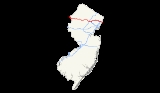
Interstate 80 in New Jersey
Encyclopedia
Interstate 80 is a major Interstate Highway in the United States
, running from the New York City Metropolitan Area westward to San Francisco, California. In the state of New Jersey
, it is known as the Christopher Columbus Highway and runs 68.54 miles (110.3 km) from the Delaware Water Gap Toll Bridge
over the Delaware River
at the Delaware Water Gap
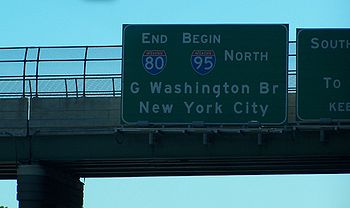
to its eastern terminus at I-95
in Teaneck
, Bergen County
. I-95 continues compass east from the end of I-80 to the George Washington Bridge
for access to New York City
; access is also provided via the I-280
spur towards the Holland Tunnel
and US 46 to Route 3, or I-95, towards the Lincoln Tunnel
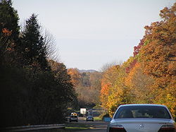
. Throughout New Jersey, I-80 runs parallel to US 46. The highway heads through rural areas of Warren
and Sussex
counties before heading into more suburban surroundings in Morris County
. As the road continues into Passaic
and Bergen counties, it heads into more urban areas.
A freeway along the I-80 corridor had been planned in 1936 and again in 1955 to provide relief along US 46 between the George Washington Bridge and the Delaware Water Gap. With the establishment of the Interstate Highway System, this planned freeway, which had been identified in some planning documents as the Bergen-Passaic Expressway, would be incorporated into I-80. The freeway was built across New Jersey in various stages from the 1960s to 1973. The westernmost four miles in New Jersey was originally a rerouting of US 611 when built; that route was later realigned back into Pennsylvania. In the 1990, high-occupancy vehicle lane
s had existed on a part of I-80 in Morris County but were opened to regular traffic due to underuse. The Delaware Water Gap Toll Bridge and its approach is planned to be widened from four to six lanes, with construction beginning in 2015.
 I-80 enters Hardwick Township
, Warren County
from Pennsylvania on the Delaware Water Gap Toll Bridge
over the Delaware River
, maintained by the Delaware River Joint Toll Bridge Commission
. From this point, the four-lane freeway heads south along the east bank of the river through the Delaware Water Gap
, immediately reaching a westbound exit and eastbound entrance for Old Mine Road
. Now maintained by the New Jersey Department of Transportation
, the road makes a sharp turn to the east and comes to a U-turn ramp in both directions that also has access to the Appalachian Trail
. The highway heads south again and enters Knowlton Township
, where it comes to another set of U-turn ramps that also includes a weigh station
in the eastbound direction. After turning southeast and leaving the Delaware Water Gap, the road has a westbound right-in/right-out
for Hainesburg Road before crossing under the abandoned Lackawanna Cutoff. I-80 widens to six lanes and reaches a large interchange with the western terminus of US 46
, Route 94, and Decatur Street in Columbia
, where development near the route increases. After this interchange, the freeway turns east away from the Delaware River and crosses over Paulins Kill
before it continues through wooded and hilly areas containing some farms, with the eastbound direction widening from three to four lanes and the highway median also widens.
Upon crossing into Blairstown Township
, the eastbound direction narrows down to three lanes. In Hope Township
, I-80 reaches an interchange with CR 521
that also provides access to CR 519
and the Land of Make Believe amusement park. The highway widens to eight lanes briefly after this interchange before narrowing to six lanes. In Frelinghuysen Township
, the freeway carries four lanes eastbound and three lanes westbound. Upon coming into Allamuchy Township
, I-80 has six lanes before gaining a fourth eastbound lane as it comes to the CR 517
exit. This exit gives the highway access to Allamuchy Mountain State Park
. Following this, the road runs through densely forested areas of Allamuchy Mountain State Park, coming to a westbound rest area
. The eastbound direction becomes three lanes again before the road passes through Byram Township
in Sussex County
.
, I-80 enters Mount Olive Township
in Morris County
and passes through more woodland with a narrower median. The road comes to a trumpet interchange with US 206
and forms a concurrency
with that route as it bypasses Netcong
to the south. After turning southeast and passing near suburban business parks, the highway crosses over New Jersey Transit
’s Morristown Line
/Montclair-Boonton Line
and reaches the US 46 partial interchange. This interchange has only a westbound exit and eastbound entrance. The freeway crosses a small corner of Netcong and Mount Olive Township again before continuing into Roxbury Township
, where it comes to a modified cloverleaf interchange
. At this interchange, Route 183
heads north into Netcong and US 206 splits from I-80 by heading south. The road continues through wooded areas containing some suburban development as it comes to the CR 631 interchange, which also provides access to eastbound US 46. The road crosses the New Jersey Transit line again and parallels it a short distance to the north as it comes into Mount Arlington
and reaches the Howard Boulevard exit. I-80 continues back into Roxbury Township and comes to a westbound weigh station with the eastbound one being abandoned. After this, the road heads farther north of the railroad tracks and briefly passes through Jefferson Township
and Rockaway Township
before continuing into Wharton
. Here, the freeway has an eastbound exit to CR 634 that provides access to Route 15 before it reaches the interchange with Route 15 proper that lacks an eastbound exit.
The highway continues back into Rockaway Township as it widens to eight lanes and comes to the CR 661 exit near the Rockaway Townsquare shopping mall. Suburban development near the highway becomes more dense at this point as I-80 briefly passes through a corner of Rockaway
before coming to the interchange with CR 513
in Rockaway Township. The freeway turns southeast here into Denville
. In the center of Denville, it has an eastbound exit and westbound entrance serving US 46 that also provides access to Route 53
. There is a westbound exit and eastbound entrance serving both US 46 and Route 53 as the road begins to turn more to the east. I-80 turns south and crosses the New Jersey Transit Montclair-Boonton Line before it enters Parsippany-Troy Hills
. The highway makes a turn east as it comes into an area of business parks, with the median widening before an interchange serving US 202
and CR 654. The median narrows again before I-80 reaches the I-287
interchange that also has movements to US 46 and Smith Road to and from the east.
Past I-287, I-80 gains local-express lanes
with a 3-3-3-3 configuration. The road continues past more commercial areas, with the local lanes having an eastbound exit and westbound entrance at CR 637. After this, there is a large interchange with US 46 and the western terminus of I-280
, at which point the local-express lanes end. From this point, I-80 continues east through wooded areas as a six-lane freeway, crossing into Montville. In Montville, there is a partial interchange providing access to Hook Mountain Road. After a turn to the northeast, the highway comes into Fairfield Township, Essex County
, continuing through wooded surroundings as it heads north before turning east. Development near the road increases as it comes to the westbound exit and eastbound entrance with CR 613.
 After crossing the Passaic River again, I-80 enters Wayne
in Passaic County
. Here, the road passes under the Montclair-Boonton Line before coming to the Spaghetti Junction with Route 23 and US 46 near the Willowbrook Mall
. At this point, the freeway widens to eight lanes and continues into Totowa
, passing near more commercial areas as it comes to an interchange with CR 642 that has access to and from the west. A short distance later, there is a westbound exit and eastbound entrance serving Route 62 and CR 646. I-80 crosses the Passaic River a third time and enters Woodland Park, where it turns to the northeast past suburban neighborhoods. In Woodland Park, there is an interchange serving CR 636. Past this, the freeway enters Paterson
and turns east into urban areas as it comes to the interchange at the Route 19 freeway. After Route 19, I-80 runs above Paterson on a viaduct before coming to the exit for CR 649 (Madison Avenue). The road returns to ground level near urban neighborhoods as it comes to an eastbound exit and westbound entrance serving Market Street. A short distance later, I-80 encounters Route 20 at an interchange.
After a fourth crossing of the Passaic River, I-80 comes into Elmwood Park
in Bergen County
. Immediately after the river, the highway reaches the CR 507
exit. It continues near suburban neighborhoods as it comes to an interchange with the Garden State Parkway
on the border of Elmwood Park and Saddle Brook
that also has connections to CR 67. At the Garden State Parkway, I-80 gains a 2-2 local-express lane configuration eastbound while the westbound direction carries four lanes. The next interchange along the road is with CR 79, and is a westbound entrance and an eastbound exit accessible from the local lanes. The freeway turns south along the west bank of the Saddle River, eventually crossing it into Lodi
. Immediately after, there is a diamond interchange
at Riverview Avenue that provides access to Route 4 and Route 17. Heading southeast, I-80 comes to an interchange at Route 17, which provides access to US 46 to the south, Route 4 to the north, and various local roads. At this point, I-80 runs between the travel lanes of Route 17 as it continues into Hackensack
. Past Route 17, I-80 gains a 3-2-2-3 local-express lane configuration and passes industrial parks, running through a small part of South Hackensack
. Here, there is an interchange to Green Street before the highway comes into Teterboro
. Turning east, the freeway runs through South Hackensack before entering Hackensack, where an exit provides access to CR 124 (Hudson Street). The road passes near neighborhoods before crossing the Hackensack River
into Ridgefield Park
, where there is an exit for 2nd Avenue. The freeway passes through a corner of Bogota
before it continues into Teaneck
. In Teaneck, I-80 reaches its eastern terminus at the interchange with I-95
(the New Jersey Turnpike
). At this point, I-95 and the Turnpike continue north towards the George Washington Bridge
.
. This proposal was considered again in the 1955. Coming off the George Washington Bridge, Route 4 and US 46 already provided high-speed corridors, but they were overloaded, and so a new corridor in between, the Bergen-Passaic Expressway, was planned to run from the bridge to Paterson. The planned route west to the Delaware Water Gap was designated in 1956 as Federal Aid Interstate Route 101 by the New Jersey State Highway Department. It first received the I-82 designation before finally becoming a part of I-80 in 1958. The easternmost section of the route, leading to the bridge, had become part of I-95.
The section of I-80 through the Delaware Water Gap had already opened on December 16, 1953, running from the Delaware Water Gap Toll Bridge to Route 94 at Columbia. This road was signed as a realignment of US 611 from Pennsylvania, later receiving the I-80 designation. The old alignment of US 611 in Pennsylvania had become US 611 Alternate. In the 1960s, the US 611 alignment was moved back to the Pennsylvania side of the river. By 1966, I-80 had been completed from Netcong to Denville and from Paterson to I-95. By 1969, the section between I-280 in Parsippany and Route 23 in Wayne was finished. Also around this time, US 611 was moved off of I-80 and back into Pennsylvania, replacing US 611 Alternate. By 1971, the section between Wayne and Paterson
was completed along with the part between US 202 and I-280. A 3½-mile section between US 46 in Denville
and US 202 Parsippany-Troy Hills
, was opened in September 1973. Also in 1973, the section between US 206 in Netcong and US 46 and Route 94 in Columbia was completed, and the interchange in Columbia was realigned into a complex array of ramps.
In the 1990s, high-occupancy vehicle lane
s were built along I-80 between Rockaway and Parsippany. These HOV lanes, along with the ones that had been built on I-287, were opened to regular traffic in 1998 due to lack of usage, and the state did not have to repay the federal government the $240 million to build the lanes. On June 22, 2001, a tanker crashed on a westbound bridge on I-80 in Denville, causing a fiery explosion that damaged the bridge and forced its demolition. A temporary bridge had to be built and traffic on this part of I-80 as well as adjacent roads was snarled; in addition, a state of emergency had been declared for Morris County. The new I-80 bridge opened in September 2001.
I-80, like many other highways in New Jersey, once had solar powered emergency call boxes every 1 miles (1.6 km), however with the advent of cell phones the usage of these call boxes became extremely limited. To save on maintenance costs, the NJDOT removed these call boxes in 2005. The Delaware River Joint Toll Bridge Commission is going to widen the Delaware Water Gap Toll Bridge that carries I-80 over the Delaware River to six lanes. This project is not planned to begin until 2015.
!County
!Location
!Mile
!Exit
!Destinations
!Notes
|-
|rowspan=10|Warren
|rowspan=3|Hardwick Township
|0.00
|colspan=3 align="center"|Delaware Water Gap Toll Bridge
over the Delaware River
|-
|0.10
|1
|Old Mine Road
– Millbrook, Flatbrookville
|
|-
|0.87
|
|U-turn
|Access to Appalachian Trail
|-
|rowspan=5|Knowlton Township
|2.05
|
|U-turn, weigh station
|
|-
|3.39
|3
|Hainesburg Road
|Westbound exit and entrance
|-
|4.20
|4A
|Decatur Street – Columbia
|Westbound exit is via exit 4B
|-
|rowspan=2|4.58
|4B
|, Portland
|
|-
|4C
|
|
|-
|Hope Township
|12.03
|12
|
|
|-
|Allamuchy Township
|19.88
|19
|
|
|-
|rowspan=24|Morris
|rowspan=2|Mt. Olive Township
|25.25
|25
|
|West end of US 206 overlap
|-
|26.25
|26
|
|Westbound exit and eastbound entrance
|-
|rowspan=3|Roxbury Township
|rowspan=2|27.19
|27A
|
|East end of US 206 overlap
|-
|27B
|
|
|-
|28.91
|28
|
|
|-
|Borough of Mt. Arlington
|30.61
|30
|
|
|-
|rowspan=2|Wharton
|33.58
|rowspan=2|34
|
|Eastbound exit only
|-
|34.02
|
|No eastbound exit; signed as exits 34A (south) and 34B (north)
|-
|rowspan=2|Rockaway Township
|35.33
|35
|
|Signed as exits 35A (Dover) and 35B (Mount Hope) westbound
|-
|37.63
|37
|
|
|-
|rowspan=2|Denville Township
|38.81
|38
|
|Eastbound exit and westbound entrance
|-
|39.57
|39
|
|Westbound exit and eastbound entrance
|-
|rowspan=11|Parsippany-Troy Hills Township
|42.46
|42A
|
|
|-
|42.46
|42B
|
|No eastbound exit
|-
|42.46
|42C
|
|Eastbound exit and westbound entrance
|-
|43.62
|43
|
|Signed as exits 43A (south) and 43B (north) westbound
|-
|colspan="4" align="center"|Local and express lanes split eastbound, merge westbound
|-
|
|
|
|Westbound exit and eastbound entrance; splits from exit 43B
|-
|45.34
|45
|
|Eastbound exit and westbound entrance
|-
|46.36
|47A
|
|Eastbound exit and westbound entrance
|-
|colspan="4" align="center"|Local and express lanes split westbound, merge eastbound
|-
|rowspan=2|46.50
|47B
|
|Eastbound exit and westbound entrance
|-
|47
|
|Westbound exit and eastbound entrance
|-
|Montville Township
|47.83
|48
|Hook Mountain Road – Montville, Pine Brook
|Westbound exit and eastbound entrance
|-
|Essex
|Fairfield Twp
|52.48
|52
|, Fairfield, The Caldwells
|Westbound exit and eastbound entrance
|-
|rowspan=11|Passaic
|rowspan=3|Wayne Township
|rowspan=2|53.62
|rowspan=2|53
|
|Eastbound exit and westbound entrance
|-
|
|Westbound exit and eastbound entrance
|-
|54.73
|54
|
|Eastbound exit and westbound entrance
|-
|Boro of Totowa
|55.21
|55
|
|Westbound exit and eastbound entrance; signed as exits 55A (Little Falls) and 55B (Totowa)
|-
|Woodland Park
|57.07
|56
|
|Signed as exits 56A (Woodland Park) and 56B (Paterson) eastbound
|-
|rowspan=6|City of Paterson
|58.22
|57A
|
|
|-
|58.22
|57B
|Downtown Paterson
|
|-
|58.37
|57C
|
|Westbound exit and eastbound entrance
|-
|59.06
|58
|
|Signed as exits 58A (Clifton) and 58B (Paterson)
|-
|60.04
|59
|Market Street – Paterson
|Westbound exit and eastbound entrance
|-
|60.41
|60
|
|No ramp from I-80 west to NJ 20 south (use exit 59)
|-
|rowspan=14|Bergen
|Boro of Elmwood Park
|60.81
|61
|
|
|-
|rowspan=3|Saddle Brook Township
|62.34
|62A
|
|Signed as exit 62 westbound
|-
|colspan="4" align="center"|Local and express lanes split eastbound
|-
|
|62B
|
|Eastbound exit and westbound entrance
|-
|rowspan=2|Boro of Lodi
|63.82
|63
|
|
|-
|colspan="4" align="center"|Local and express lanes merge westbound
|-
|rowspan=5|City of Hackensack
|65.19
|64A
|
|Westbound exit and eastbound entrance
|-
|65.05-
65.19
|64
|
|Eastbound exit and westbound entrance
|-
|65.40
|64B
|
|Westbound exit and eastbound entrance
|-
|65.67
|65
|Green Street – Teterboro
, South Hackensack
|
|-
|66.55
|66
|
|
|-
|Village of Ridgefield Park
|67.22
|67
|2nd Ave – Bogota
, Ridgefield Park
|Eastbound exit and westbound entrance
|-
|rowspan=2|Teaneck Township
|68.17
|68A
|
|Eastbound exit and westbound entrance
|-
|68.54
|68B
|, New York
|Eastbound exit and westbound entrance
United States
The United States of America is a federal constitutional republic comprising fifty states and a federal district...
, running from the New York City Metropolitan Area westward to San Francisco, California. In the state of New Jersey
New Jersey
New Jersey is a state in the Northeastern and Middle Atlantic regions of the United States. , its population was 8,791,894. It is bordered on the north and east by the state of New York, on the southeast and south by the Atlantic Ocean, on the west by Pennsylvania and on the southwest by Delaware...
, it is known as the Christopher Columbus Highway and runs 68.54 miles (110.3 km) from the Delaware Water Gap Toll Bridge
Delaware Water Gap Toll Bridge
The Delaware Water Gap Toll Bridge is a toll bridge that carries I-80 across the Delaware River at the Delaware Water Gap, connecting Hardwick Township, New Jersey and Delaware Water Gap, Pennsylvania. The bridge was built by the Delaware River Joint Toll Bridge Commission...
over the Delaware River
Delaware River
The Delaware River is a major river on the Atlantic coast of the United States.A Dutch expedition led by Henry Hudson in 1609 first mapped the river. The river was christened the South River in the New Netherland colony that followed, in contrast to the North River, as the Hudson River was then...
at the Delaware Water Gap
Delaware Water Gap
The Delaware Water Gap is on the border of New Jersey and Pennsylvania where the Delaware River cuts through a large ridge of the Appalachian Mountains...
to its eastern terminus at I-95
Interstate 95 in New Jersey
Interstate 95 is a major Interstate Highway that traverses the full extent of the East Coast of the United States, from Florida to Maine...
in Teaneck
Teaneck, New Jersey
Teaneck is a township in Bergen County, New Jersey, and a suburb in the New York metropolitan area. As of the 2010 United States Census, the township population was 39,776, making it the second-most populous among the 70 municipalities in Bergen County....
, Bergen County
Bergen County, New Jersey
Bergen County is the most populous county of the state of New Jersey, United States. As of the 2010 United States Census, its population was 905,116. The county is part of the New York City Metropolitan Area. Its county seat is Hackensack...
. I-95 continues compass east from the end of I-80 to the George Washington Bridge
George Washington Bridge
The George Washington Bridge is a suspension bridge spanning the Hudson River, connecting the Washington Heights neighborhood in the borough of Manhattan in New York City to Fort Lee, Bergen County, New Jersey. Interstate 95 and U.S. Route 1/9 cross the river via the bridge. U.S...
for access to New York City
New York City
New York is the most populous city in the United States and the center of the New York Metropolitan Area, one of the most populous metropolitan areas in the world. New York exerts a significant impact upon global commerce, finance, media, art, fashion, research, technology, education, and...
; access is also provided via the I-280
Interstate 280 (New Jersey)
Interstate 280 is a Interstate Highway in the U.S. state of New Jersey. It provides a spur from I-80 in Parsippany-Troy Hills, Morris County to Newark, and I-95 Interstate 280 (abbreviated I-280) is a Interstate Highway in the U.S. state of New Jersey. It provides a spur from I-80 in...
spur towards the Holland Tunnel
Holland Tunnel
The Holland Tunnel is a highway tunnel under the Hudson River connecting the island of Manhattan in New York City with Jersey City, New Jersey at Interstate 78 on the mainland. Unusual for an American public works project, it is not named for a government official, politician, or local hero or...
and US 46 to Route 3, or I-95, towards the Lincoln Tunnel
Lincoln Tunnel
The Lincoln Tunnel is a long tunnel under the Hudson River, connecting Weehawken, New Jersey and the borough of Manhattan in New York City.-History:...
. Throughout New Jersey, I-80 runs parallel to US 46. The highway heads through rural areas of Warren
Warren County, New Jersey
Warren County is a county located in the U.S. state of New Jersey. As of the 2010 Census, the population was 108,692. Its county seat is Belvidere...
and Sussex
Sussex County, New Jersey
The County of Sussex is the northernmost county in the State of New Jersey. It is part of the New York City Metropolitan Area. As of the 2010 Federal decennial census, 149,265 persons resided in Sussex County...
counties before heading into more suburban surroundings in Morris County
Morris County, New Jersey
Morris County is a county located in the U.S. state of New Jersey, about west of New York City. According to the United States 2010 Census, the population was 492,276. It is part of the New York Metropolitan Area. Its county seat is Morristown....
. As the road continues into Passaic
Passaic County, New Jersey
Passaic County is a county located in the U.S. state of New Jersey. As of the 2010 Census, the population was 501,226. Its county seat is Paterson...
and Bergen counties, it heads into more urban areas.
A freeway along the I-80 corridor had been planned in 1936 and again in 1955 to provide relief along US 46 between the George Washington Bridge and the Delaware Water Gap. With the establishment of the Interstate Highway System, this planned freeway, which had been identified in some planning documents as the Bergen-Passaic Expressway, would be incorporated into I-80. The freeway was built across New Jersey in various stages from the 1960s to 1973. The westernmost four miles in New Jersey was originally a rerouting of US 611 when built; that route was later realigned back into Pennsylvania. In the 1990, high-occupancy vehicle lane
High-occupancy vehicle lane
In transportation engineering and transportation planning, a high-occupancy vehicle lane is a lane reserved for vehicles with a driver and one or more passengers...
s had existed on a part of I-80 in Morris County but were opened to regular traffic due to underuse. The Delaware Water Gap Toll Bridge and its approach is planned to be widened from four to six lanes, with construction beginning in 2015.
Warren and Sussex counties
Hardwick Township, New Jersey
-Demographics:As of the census of 2000, there were 1,464 people, 502 households, and 410 families residing in the township. The population density was 40.1 people per square mile . There were 530 housing units at an average density of 14.5 per square mile...
, Warren County
Warren County, New Jersey
Warren County is a county located in the U.S. state of New Jersey. As of the 2010 Census, the population was 108,692. Its county seat is Belvidere...
from Pennsylvania on the Delaware Water Gap Toll Bridge
Delaware Water Gap Toll Bridge
The Delaware Water Gap Toll Bridge is a toll bridge that carries I-80 across the Delaware River at the Delaware Water Gap, connecting Hardwick Township, New Jersey and Delaware Water Gap, Pennsylvania. The bridge was built by the Delaware River Joint Toll Bridge Commission...
over the Delaware River
Delaware River
The Delaware River is a major river on the Atlantic coast of the United States.A Dutch expedition led by Henry Hudson in 1609 first mapped the river. The river was christened the South River in the New Netherland colony that followed, in contrast to the North River, as the Hudson River was then...
, maintained by the Delaware River Joint Toll Bridge Commission
Delaware River Joint Toll Bridge Commission
The Delaware River Joint Toll Bridge Commission is a bistate, public agency charged with providing safe, dependable and efficient river crossings between Pennsylvania and New Jersey. The DRJTBC was established under legislation enacted in the two states in 1934. The federal Compact for the...
. From this point, the four-lane freeway heads south along the east bank of the river through the Delaware Water Gap
Delaware Water Gap
The Delaware Water Gap is on the border of New Jersey and Pennsylvania where the Delaware River cuts through a large ridge of the Appalachian Mountains...
, immediately reaching a westbound exit and eastbound entrance for Old Mine Road
Old Mine Road
Old Mine Road is a road in New Jersey and New York said to be one of the oldest continuously-used roads in the United States of America. At a length of 104 miles, it stretches from the Delaware Water Gap National Recreation Area to the vicinity of Kingston, New York.Among the theories regarding the...
. Now maintained by the New Jersey Department of Transportation
New Jersey Department of Transportation
The New Jersey Department of Transportation is the agency responsible for transportation issues and policy in New Jersey. It is headed by the Commissioner of Transportation...
, the road makes a sharp turn to the east and comes to a U-turn ramp in both directions that also has access to the Appalachian Trail
Appalachian Trail
The Appalachian National Scenic Trail, generally known as the Appalachian Trail or simply the AT, is a marked hiking trail in the eastern United States extending between Springer Mountain in Georgia and Mount Katahdin in Maine. It is approximately long...
. The highway heads south again and enters Knowlton Township
Knowlton Township, New Jersey
- Local government :The Knowlton Township Committee consists of Mayor Frank Van Horn , Deputy Mayor Ronald Farber , Theresa Capriccio , René Mathez and Scott Odorizzi ....
, where it comes to another set of U-turn ramps that also includes a weigh station
Weigh station
A weigh station is a checkpoint along a highway to inspect vehicular weights. Usually, trucks and commercial vehicles are subject to the inspection....
in the eastbound direction. After turning southeast and leaving the Delaware Water Gap, the road has a westbound right-in/right-out
Right-in/right-out
Right-in/right-out and left-in/left-out refer to a type of road intersection where turning movements of vehicles are restricted. A RIRO permits only right turns and a LILO permits only left turns. RIRO is usual where vehicles drive on the right, and LILO is usual where vehicles drive on the left...
for Hainesburg Road before crossing under the abandoned Lackawanna Cutoff. I-80 widens to six lanes and reaches a large interchange with the western terminus of US 46
U.S. Route 46
U.S. Route 46 is an east–west U.S. Highway, running for , completely within the state of New Jersey. The west end is at an interchange with Interstate 80 and Route 94 in Columbia, Warren County on the Delaware River...
, Route 94, and Decatur Street in Columbia
Columbia, New Jersey
Columbia is a census-designated place within Knowlton Township in Warren County, New Jersey, United States. The area is served as United States Postal Service ZIP Code 07832.As of the United States 2010 Census, the population for Columbia was 229....
, where development near the route increases. After this interchange, the freeway turns east away from the Delaware River and crosses over Paulins Kill
Paulins Kill
The Paulins Kill is a tributary of the Delaware River in northwestern New Jersey in the United States...
before it continues through wooded and hilly areas containing some farms, with the eastbound direction widening from three to four lanes and the highway median also widens.
Upon crossing into Blairstown Township
Blairstown Township, New Jersey
-Demographics:As of the census of 2000, there were 5,747 people, 2,040 households, and 1,638 families residing in the township. The population density was 185.3 people per square mile . There were 2,136 housing units at an average density of 68.9 per square mile...
, the eastbound direction narrows down to three lanes. In Hope Township
Hope Township, New Jersey
-Demographics:As of the census of 2000, there were 1,891 people, 697 households, and 538 families residing in the township. The population density was 102.2 people per square mile . There were 747 housing units at an average density of 40.4 per square mile...
, I-80 reaches an interchange with CR 521
County Route 521 (New Jersey)
County Route 521 is a county highway in the U.S. state of New Jersey. The highway extends 43.71 miles from High Street in Hope Township to the New York state line in Montague Township....
that also provides access to CR 519
County Route 519 (New Jersey)
County Route 519 is a county highway in the U.S. state of New Jersey. The highway extends from Daniel Bray Highway in Delaware Township to the New York state line in Wantage Township...
and the Land of Make Believe amusement park. The highway widens to eight lanes briefly after this interchange before narrowing to six lanes. In Frelinghuysen Township
Frelinghuysen Township, New Jersey
-Demographics:As of the census of 2000, there were 2,083 people, 722 households, and 578 families residing in the township. The population density was 88.9 people per square mile . There were 755 housing units at an average density of 32.2 per square mile...
, the freeway carries four lanes eastbound and three lanes westbound. Upon coming into Allamuchy Township
Allamuchy Township, New Jersey
-Demographics:As of the census of 2000, there were 3,877 people, 1,692 households, and 1,133 families residing in the township. The population density was 188.8 people per square mile . There were 1,774 housing units at an average density of 86.4 per square mile...
, I-80 has six lanes before gaining a fourth eastbound lane as it comes to the CR 517
County Route 517 (New Jersey)
County Route 517 is a county highway in the U.S. state of New Jersey. The highway extends from Lamington Road in Tewksbury Township to the New York state line in Vernon Township where it continues as Orange County Route 26. It mainly traverses through small, rural communities and unincorporated...
exit. This exit gives the highway access to Allamuchy Mountain State Park
Allamuchy Mountain State Park
Allamuchy Mountain State Park is located in Byram Township, New Jersey, United States. The park is operated and maintained by the New Jersey Division of Parks and Forestry. There are more than of unmarked trails in the northern section of Allamuchy, and of marked multi-use trails.The park is in...
. Following this, the road runs through densely forested areas of Allamuchy Mountain State Park, coming to a westbound rest area
Rest area
A rest area, travel plaza, rest stop, or service area is a public facility, located next to a large thoroughfare such as a highway, expressway, or freeway at which drivers and passengers can rest, eat, or refuel without exiting on to secondary roads...
. The eastbound direction becomes three lanes again before the road passes through Byram Township
Byram Township, New Jersey
Byram Township — "The Township of Lakes" — is a Township in Sussex County, New Jersey, United States. As of the 2010 United States Census, the township population was 8,350...
in Sussex County
Sussex County, New Jersey
The County of Sussex is the northernmost county in the State of New Jersey. It is part of the New York City Metropolitan Area. As of the 2010 Federal decennial census, 149,265 persons resided in Sussex County...
.
Morris and Essex counties
Upon crossing the Musconetcong RiverMusconetcong River
The Musconetcong River is a tributary of the Delaware River in northwestern New Jersey in the United States. It flows through the rural mountainous country of northwestern New Jersey. Part of it is a National Wild and Scenic River....
, I-80 enters Mount Olive Township
Mount Olive Township, New Jersey
-Transportation:The major roads that pass through include U.S. Route 46 through the center, U.S. Route 206 in the east and northeast part and Interstate 80 in the north .-Demographics:As of the census of 2000, there were 24,193 people, 9,068 households, and 6,374 families residing in the...
in Morris County
Morris County, New Jersey
Morris County is a county located in the U.S. state of New Jersey, about west of New York City. According to the United States 2010 Census, the population was 492,276. It is part of the New York Metropolitan Area. Its county seat is Morristown....
and passes through more woodland with a narrower median. The road comes to a trumpet interchange with US 206
U.S. Route 206
U.S. Route 206 is a long north–south United States highway in New Jersey and Pennsylvania, United States. Only about a half a mile of its length is in Pennsylvania; the Milford-Montague Toll Bridge carries it over the Delaware River into New Jersey, where it is the remainder of the route...
and forms a concurrency
Concurrency (road)
A concurrency, overlap, or coincidence in a road network is an instance of one physical road bearing two or more different highway, motorway, or other route numbers...
with that route as it bypasses Netcong
Netcong, New Jersey
Netcong is a Borough in Morris County, New Jersey, United States. As of the United States 2000 Census, the borough population was 2,580. Its estimated population in 2006 was 3,292...
to the south. After turning southeast and passing near suburban business parks, the highway crosses over New Jersey Transit
New Jersey Transit
The New Jersey Transit Corporation is a statewide public transportation system serving the United States state of New Jersey, and New York, Orange, and Rockland counties in New York State...
’s Morristown Line
Morristown Line
The Morristown Line is one of New Jersey Transit's commuter lines and is one of two branches that run along the Morris and Essex Lines. Out of 60 inbound and 58 outbound daily weekday trains, 28 inbound and 26 outbound trains use the Kearny Connection to Secaucus Junction and New York Penn...
/Montclair-Boonton Line
Montclair-Boonton Line
The Montclair-Boonton Line is a commuter rail line of New Jersey Transit Rail Operations. It is part of the Hoboken Division. The line is a consolidation of three individual lines: the former Delaware, Lackawanna & Western Railroad's Montclair Branch, which ran from Hoboken Terminal to Bay Street,...
and reaches the US 46 partial interchange. This interchange has only a westbound exit and eastbound entrance. The freeway crosses a small corner of Netcong and Mount Olive Township again before continuing into Roxbury Township
Roxbury Township, New Jersey
-Demographics:As of the census of 2000, there were 23,883 people, 8,364 households, and 6,532 families residing in the township. The population density was 1,117.4 people per square mile . There were 8,550 housing units at an average density of 400.0 per square mile...
, where it comes to a modified cloverleaf interchange
Cloverleaf interchange
A cloverleaf interchange is a two-level interchange in which left turns, reverse direction in left-driving regions, are handled by ramp roads...
. At this interchange, Route 183
New Jersey Route 183
Route 183 is a long state highway in the northern regions of New Jersey. The southern end of NJ 183 is at an interchange with Interstate 80 and U.S. Route 206 near Netcong, while the northern end is at an interchange with US 206 in Stanhope. The route heads northward through downtown Netcong and...
heads north into Netcong and US 206 splits from I-80 by heading south. The road continues through wooded areas containing some suburban development as it comes to the CR 631 interchange, which also provides access to eastbound US 46. The road crosses the New Jersey Transit line again and parallels it a short distance to the north as it comes into Mount Arlington
Mount Arlington, New Jersey
-History:While Mount Arlington is now mostly a suburban residential community, it was once a thriving resort town. In the era before the world wars and the advent of air travel, it was a welcome respite for the residents of nearby New York City and Newark....
and reaches the Howard Boulevard exit. I-80 continues back into Roxbury Township and comes to a westbound weigh station with the eastbound one being abandoned. After this, the road heads farther north of the railroad tracks and briefly passes through Jefferson Township
Jefferson Township, New Jersey
Jefferson Township is the northern-most township in Morris County, New Jersey, United States. As of the 2010 United States Census, the township population was 21,314....
and Rockaway Township
Rockaway Township, New Jersey
Rockaway Township is a township in Morris County, New Jersey, United States. As of the 2010 United States Census, the township population was 24,156....
before continuing into Wharton
Wharton, New Jersey
Wharton is a Borough in Morris County, New Jersey, United States. As of the 2000 United States Census, the borough population was 6,298.What is now Wharton was originally incorporated as the borough of Port Oram by an Act of the New Jersey Legislature on June 26, 1895, from portions of Randolph...
. Here, the freeway has an eastbound exit to CR 634 that provides access to Route 15 before it reaches the interchange with Route 15 proper that lacks an eastbound exit.
The highway continues back into Rockaway Township as it widens to eight lanes and comes to the CR 661 exit near the Rockaway Townsquare shopping mall. Suburban development near the highway becomes more dense at this point as I-80 briefly passes through a corner of Rockaway
Rockaway, New Jersey
Rockaway is a borough in Morris County, New Jersey, United States. As of the 2010 United States Census, the borough population was 6,438.Rockaway was formed as a borough on June 19, 1894, from portions of Rockaway Township, based on the results of a referendum held the previous...
before coming to the interchange with CR 513
County Route 513 (New Jersey)
County Route 513 is a county highway in the U.S. state of New Jersey. The highway extends from Kingwood Avenue in Frenchtown to Lakeside Road in West Milford...
in Rockaway Township. The freeway turns southeast here into Denville
Denville, New Jersey
Denville is a township in Morris County, New Jersey, United States. As of the 2010 United States Census, the township population was 16,635. Denville is known as the "Hub of Morris County" for its location along major transportation routes at the center of the county...
. In the center of Denville, it has an eastbound exit and westbound entrance serving US 46 that also provides access to Route 53
New Jersey Route 53
-External links:***...
. There is a westbound exit and eastbound entrance serving both US 46 and Route 53 as the road begins to turn more to the east. I-80 turns south and crosses the New Jersey Transit Montclair-Boonton Line before it enters Parsippany-Troy Hills
Parsippany-Troy Hills, New Jersey
Parsippany-Troy Hills Township, commonly called Parsippany, is a township in Morris County, New Jersey, United States. As of the 2000 United States Census, the township population was 50,649. The name Parsippany comes from the Lenape Native American word parsipanong, which means "the place where...
. The highway makes a turn east as it comes into an area of business parks, with the median widening before an interchange serving US 202
U.S. Route 202 in New Jersey
U.S. Route 202 is a U.S. Highway running from New Castle, Delaware northeast to Bangor, Maine. In the U.S. state of New Jersey, the route runs from the New Hope-Lambertville Toll Bridge over the Delaware River at the Pennsylvania border in Delaware Township, Hunterdon County near Lambertville...
and CR 654. The median narrows again before I-80 reaches the I-287
Interstate 287
Interstate 287 is an auxiliary Interstate Highway in the U.S. states of New Jersey and New York. It is a partial beltway around New York City, serving the northern half of New Jersey and the counties of Rockland and Westchester in New York...
interchange that also has movements to US 46 and Smith Road to and from the east.
Past I-287, I-80 gains local-express lanes
Local-express lanes
A Local-express lane system is an arrangement of roadways within a major highway providing one of more roadways for express lanes with a limited number of entrances and exits and also separate roadways for local or collector lanes which provide access to all interchanges...
with a 3-3-3-3 configuration. The road continues past more commercial areas, with the local lanes having an eastbound exit and westbound entrance at CR 637. After this, there is a large interchange with US 46 and the western terminus of I-280
Interstate 280 (New Jersey)
Interstate 280 is a Interstate Highway in the U.S. state of New Jersey. It provides a spur from I-80 in Parsippany-Troy Hills, Morris County to Newark, and I-95 Interstate 280 (abbreviated I-280) is a Interstate Highway in the U.S. state of New Jersey. It provides a spur from I-80 in...
, at which point the local-express lanes end. From this point, I-80 continues east through wooded areas as a six-lane freeway, crossing into Montville. In Montville, there is a partial interchange providing access to Hook Mountain Road. After a turn to the northeast, the highway comes into Fairfield Township, Essex County
Essex County, New Jersey
Essex County is a county located in the northeastern part of the U.S. state of New Jersey. As of the United States 2010 Census, the population was 783,969, ranking it third in the state after Bergen County and Middlesex County; Essex County's population has declined from 786,147 as of the bureau's...
, continuing through wooded surroundings as it heads north before turning east. Development near the road increases as it comes to the westbound exit and eastbound entrance with CR 613.
Passaic and Bergen counties
Wayne, New Jersey
Wayne is a Township in Passaic County, New Jersey, United States, located less than from midtown Manhattan. As of the United States 2000 Census, the township had a total population of 54,069....
in Passaic County
Passaic County, New Jersey
Passaic County is a county located in the U.S. state of New Jersey. As of the 2010 Census, the population was 501,226. Its county seat is Paterson...
. Here, the road passes under the Montclair-Boonton Line before coming to the Spaghetti Junction with Route 23 and US 46 near the Willowbrook Mall
Willowbrook Mall (Wayne, New Jersey)
Willowbrook Mall is a two-level, major shopping center located in Wayne, New Jersey, United States. It is near the intersection of U.S. Route 46, Route 23 and Interstate 80. The mall opened in 1969 and was expanded or renovated in 1970, 1988, and 2006...
. At this point, the freeway widens to eight lanes and continues into Totowa
Totowa, New Jersey
Totowa is a borough in Passaic County, New Jersey, United States. As of the 2000 United States Census, the borough population was 9,892.Totowa was formed as a borough by an Act of the New Jersey Legislature on March 15, 1898, from portions of the now-defunct Manchester Township and Wayne...
, passing near more commercial areas as it comes to an interchange with CR 642 that has access to and from the west. A short distance later, there is a westbound exit and eastbound entrance serving Route 62 and CR 646. I-80 crosses the Passaic River a third time and enters Woodland Park, where it turns to the northeast past suburban neighborhoods. In Woodland Park, there is an interchange serving CR 636. Past this, the freeway enters Paterson
Paterson, New Jersey
Paterson is a city serving as the county seat of Passaic County, New Jersey, United States. As of the 2010 United States Census, its population was 146,199, rendering it New Jersey's third largest city and one of the largest cities in the New York City Metropolitan Area, despite a decrease of 3,023...
and turns east into urban areas as it comes to the interchange at the Route 19 freeway. After Route 19, I-80 runs above Paterson on a viaduct before coming to the exit for CR 649 (Madison Avenue). The road returns to ground level near urban neighborhoods as it comes to an eastbound exit and westbound entrance serving Market Street. A short distance later, I-80 encounters Route 20 at an interchange.
After a fourth crossing of the Passaic River, I-80 comes into Elmwood Park
Elmwood Park, New Jersey
Elmwood Park is a borough in Bergen County, New Jersey, United States. As of the 2010 United States Census, the borough population was 19,403....
in Bergen County
Bergen County, New Jersey
Bergen County is the most populous county of the state of New Jersey, United States. As of the 2010 United States Census, its population was 905,116. The county is part of the New York City Metropolitan Area. Its county seat is Hackensack...
. Immediately after the river, the highway reaches the CR 507
County Route 507 (New Jersey)
County Route 507 is a county highway in the U.S. state of New Jersey. The highway extends from Harrison Avenue on the Kearny-Harrison town line to the New York state line in Mahwah. Between Ho-Ho-Kus and Mahwah, this highway is known as Franklin Turnpike...
exit. It continues near suburban neighborhoods as it comes to an interchange with the Garden State Parkway
Garden State Parkway
The Garden State Parkway is a 172.4-mile limited-access toll parkway that stretches the length of New Jersey from the New York line at Montvale, New Jersey, to Cape May at New Jersey's southernmost tip. Its name refers to New Jersey's nickname, the "Garden State." Most New Jersey residents refer...
on the border of Elmwood Park and Saddle Brook
Saddle Brook, New Jersey
Saddle Brook is a township in Bergen County, New Jersey, United States. As of the 2010 United States Census, the township population was 13,659....
that also has connections to CR 67. At the Garden State Parkway, I-80 gains a 2-2 local-express lane configuration eastbound while the westbound direction carries four lanes. The next interchange along the road is with CR 79, and is a westbound entrance and an eastbound exit accessible from the local lanes. The freeway turns south along the west bank of the Saddle River, eventually crossing it into Lodi
Lodi, New Jersey
Lodi is a borough in Bergen County, New Jersey, United States. As of the 2010 United States Census, the borough population was 24,136. The borough of Lodi is governed under the 1923 Municipal Manager Law.Lodi owes its name to the Italian city of Lodi...
. Immediately after, there is a diamond interchange
Diamond interchange
A diamond interchange is a common type of road junction, used where a freeway crosses a minor road. The freeway itself is grade-separated from the minor road, one crossing the other over a bridge...
at Riverview Avenue that provides access to Route 4 and Route 17. Heading southeast, I-80 comes to an interchange at Route 17, which provides access to US 46 to the south, Route 4 to the north, and various local roads. At this point, I-80 runs between the travel lanes of Route 17 as it continues into Hackensack
Hackensack, New Jersey
Hackensack is a city in Bergen County, New Jersey, United States and the county seat of Bergen County. Although informally called Hackensack, it was officially named New Barbadoes Township until 1921. As of the 2010 United States Census, the city population was 43,010....
. Past Route 17, I-80 gains a 3-2-2-3 local-express lane configuration and passes industrial parks, running through a small part of South Hackensack
South Hackensack, New Jersey
South Hackensack Township is a township in Bergen County, New Jersey, United States. As of the 2010 United States Census, the township population was 2,378....
. Here, there is an interchange to Green Street before the highway comes into Teterboro
Teterboro, New Jersey
Teterboro is a borough in Bergen County, New Jersey, United States. As of the 2010 United States Census, the borough population was 67, making it the fourth smallest municipality, by population, in New Jersey....
. Turning east, the freeway runs through South Hackensack before entering Hackensack, where an exit provides access to CR 124 (Hudson Street). The road passes near neighborhoods before crossing the Hackensack River
Hackensack River
The Hackensack River is a river, approximately 45 miles long, in the U.S. states of New York and New Jersey, emptying into Newark Bay, a back chamber of New York Harbor. The watershed of the river includes part of the suburban area outside New York City just west of the lower Hudson River,...
into Ridgefield Park
Ridgefield Park, New Jersey
Ridgefield Park is a village in Bergen County, New Jersey, United States. The population was 12,729 at the 2010 United States Census. Of 566 municipalities statewide, Ridgefield Park is only one of three with a village type of government in New Jersey, along with Loch Arbour and Ridgewood.The...
, where there is an exit for 2nd Avenue. The freeway passes through a corner of Bogota
Bogota, New Jersey
As of the 2010 Census, Bogota had a population of 8,187. The median age was 38.6. The racial and ethnic composition of the population was 61.0% White, 9.4% Black or African American, 0.8% Native American, 9.8% Asian, 0.1% Native Hawaiian / Pacific Islander, 14.8% some other race and 4.1% reporting...
before it continues into Teaneck
Teaneck, New Jersey
Teaneck is a township in Bergen County, New Jersey, and a suburb in the New York metropolitan area. As of the 2010 United States Census, the township population was 39,776, making it the second-most populous among the 70 municipalities in Bergen County....
. In Teaneck, I-80 reaches its eastern terminus at the interchange with I-95
Interstate 95 in New Jersey
Interstate 95 is a major Interstate Highway that traverses the full extent of the East Coast of the United States, from Florida to Maine...
(the New Jersey Turnpike
New Jersey Turnpike
The New Jersey Turnpike is a toll road in New Jersey, maintained by the New Jersey Turnpike Authority. According to the International Bridge, Tunnel and Turnpike Association, the Turnpike is the nation's sixth-busiest toll road and is among one of the most heavily traveled highways in the United...
). At this point, I-95 and the Turnpike continue north towards the George Washington Bridge
George Washington Bridge
The George Washington Bridge is a suspension bridge spanning the Hudson River, connecting the Washington Heights neighborhood in the borough of Manhattan in New York City to Fort Lee, Bergen County, New Jersey. Interstate 95 and U.S. Route 1/9 cross the river via the bridge. U.S...
.
History
A freeway along the I-80 corridor was first planned in 1936 as a replacement for the cross-state US 46, running from the George Washington Bridge west to the Delaware Water Gap and Scranton, PennsylvaniaScranton, Pennsylvania
Scranton is a city in the northeastern part of Pennsylvania, United States. It is the county seat of Lackawanna County and the largest principal city in the Scranton/Wilkes-Barre metropolitan area. Scranton had a population of 76,089 in 2010, according to the U.S...
. This proposal was considered again in the 1955. Coming off the George Washington Bridge, Route 4 and US 46 already provided high-speed corridors, but they were overloaded, and so a new corridor in between, the Bergen-Passaic Expressway, was planned to run from the bridge to Paterson. The planned route west to the Delaware Water Gap was designated in 1956 as Federal Aid Interstate Route 101 by the New Jersey State Highway Department. It first received the I-82 designation before finally becoming a part of I-80 in 1958. The easternmost section of the route, leading to the bridge, had become part of I-95.
The section of I-80 through the Delaware Water Gap had already opened on December 16, 1953, running from the Delaware Water Gap Toll Bridge to Route 94 at Columbia. This road was signed as a realignment of US 611 from Pennsylvania, later receiving the I-80 designation. The old alignment of US 611 in Pennsylvania had become US 611 Alternate. In the 1960s, the US 611 alignment was moved back to the Pennsylvania side of the river. By 1966, I-80 had been completed from Netcong to Denville and from Paterson to I-95. By 1969, the section between I-280 in Parsippany and Route 23 in Wayne was finished. Also around this time, US 611 was moved off of I-80 and back into Pennsylvania, replacing US 611 Alternate. By 1971, the section between Wayne and Paterson
Paterson, New Jersey
Paterson is a city serving as the county seat of Passaic County, New Jersey, United States. As of the 2010 United States Census, its population was 146,199, rendering it New Jersey's third largest city and one of the largest cities in the New York City Metropolitan Area, despite a decrease of 3,023...
was completed along with the part between US 202 and I-280. A 3½-mile section between US 46 in Denville
Denville, New Jersey
Denville is a township in Morris County, New Jersey, United States. As of the 2010 United States Census, the township population was 16,635. Denville is known as the "Hub of Morris County" for its location along major transportation routes at the center of the county...
and US 202 Parsippany-Troy Hills
Parsippany-Troy Hills, New Jersey
Parsippany-Troy Hills Township, commonly called Parsippany, is a township in Morris County, New Jersey, United States. As of the 2000 United States Census, the township population was 50,649. The name Parsippany comes from the Lenape Native American word parsipanong, which means "the place where...
, was opened in September 1973. Also in 1973, the section between US 206 in Netcong and US 46 and Route 94 in Columbia was completed, and the interchange in Columbia was realigned into a complex array of ramps.
In the 1990s, high-occupancy vehicle lane
High-occupancy vehicle lane
In transportation engineering and transportation planning, a high-occupancy vehicle lane is a lane reserved for vehicles with a driver and one or more passengers...
s were built along I-80 between Rockaway and Parsippany. These HOV lanes, along with the ones that had been built on I-287, were opened to regular traffic in 1998 due to lack of usage, and the state did not have to repay the federal government the $240 million to build the lanes. On June 22, 2001, a tanker crashed on a westbound bridge on I-80 in Denville, causing a fiery explosion that damaged the bridge and forced its demolition. A temporary bridge had to be built and traffic on this part of I-80 as well as adjacent roads was snarled; in addition, a state of emergency had been declared for Morris County. The new I-80 bridge opened in September 2001.
I-80, like many other highways in New Jersey, once had solar powered emergency call boxes every 1 miles (1.6 km), however with the advent of cell phones the usage of these call boxes became extremely limited. To save on maintenance costs, the NJDOT removed these call boxes in 2005. The Delaware River Joint Toll Bridge Commission is going to widen the Delaware Water Gap Toll Bridge that carries I-80 over the Delaware River to six lanes. This project is not planned to begin until 2015.
Exit list
{| class=wikitable!County
!Location
!Mile
!Exit
Exit number
An exit number is a number assigned to a road junction, usually an exit from a freeway. It is usually marked on the same sign as the destinations of the exit, as well as a sign in the gore....
!Destinations
!Notes
|-
|rowspan=10|Warren
Warren County, New Jersey
Warren County is a county located in the U.S. state of New Jersey. As of the 2010 Census, the population was 108,692. Its county seat is Belvidere...
|rowspan=3|Hardwick Township
Hardwick Township, New Jersey
-Demographics:As of the census of 2000, there were 1,464 people, 502 households, and 410 families residing in the township. The population density was 40.1 people per square mile . There were 530 housing units at an average density of 14.5 per square mile...
|0.00
|colspan=3 align="center"|Delaware Water Gap Toll Bridge
Delaware Water Gap Toll Bridge
The Delaware Water Gap Toll Bridge is a toll bridge that carries I-80 across the Delaware River at the Delaware Water Gap, connecting Hardwick Township, New Jersey and Delaware Water Gap, Pennsylvania. The bridge was built by the Delaware River Joint Toll Bridge Commission...
over the Delaware River
Delaware River
The Delaware River is a major river on the Atlantic coast of the United States.A Dutch expedition led by Henry Hudson in 1609 first mapped the river. The river was christened the South River in the New Netherland colony that followed, in contrast to the North River, as the Hudson River was then...
|-
|0.10
|1
|Old Mine Road
Old Mine Road
Old Mine Road is a road in New Jersey and New York said to be one of the oldest continuously-used roads in the United States of America. At a length of 104 miles, it stretches from the Delaware Water Gap National Recreation Area to the vicinity of Kingston, New York.Among the theories regarding the...
– Millbrook, Flatbrookville
|
|-
|0.87
|
|U-turn
|Access to Appalachian Trail
Appalachian Trail
The Appalachian National Scenic Trail, generally known as the Appalachian Trail or simply the AT, is a marked hiking trail in the eastern United States extending between Springer Mountain in Georgia and Mount Katahdin in Maine. It is approximately long...
|-
|rowspan=5|Knowlton Township
Knowlton Township, New Jersey
- Local government :The Knowlton Township Committee consists of Mayor Frank Van Horn , Deputy Mayor Ronald Farber , Theresa Capriccio , René Mathez and Scott Odorizzi ....
|2.05
|
|U-turn, weigh station
Weigh station
A weigh station is a checkpoint along a highway to inspect vehicular weights. Usually, trucks and commercial vehicles are subject to the inspection....
|
|-
|3.39
|3
|Hainesburg Road
|Westbound exit and entrance
|-
|4.20
|4A
|Decatur Street – Columbia
Columbia, New Jersey
Columbia is a census-designated place within Knowlton Township in Warren County, New Jersey, United States. The area is served as United States Postal Service ZIP Code 07832.As of the United States 2010 Census, the population for Columbia was 229....
|Westbound exit is via exit 4B
|-
|rowspan=2|4.58
|4B
|, Portland
Portland, Pennsylvania
Portland is a borough in Northampton County, Pennsylvania, United States. Portland is located in the Lehigh Valley region of the state. It is part of Pennsylvania's Slate Belt.The population of Portland was 579 at the 2000 census.-Geography:...
|
|-
|4C
|
|
|-
|Hope Township
Hope Township, New Jersey
-Demographics:As of the census of 2000, there were 1,891 people, 697 households, and 538 families residing in the township. The population density was 102.2 people per square mile . There were 747 housing units at an average density of 40.4 per square mile...
|12.03
|12
|
|
|-
|Allamuchy Township
Allamuchy Township, New Jersey
-Demographics:As of the census of 2000, there were 3,877 people, 1,692 households, and 1,133 families residing in the township. The population density was 188.8 people per square mile . There were 1,774 housing units at an average density of 86.4 per square mile...
|19.88
|19
|
|
|-
|rowspan=24|Morris
Morris County, New Jersey
Morris County is a county located in the U.S. state of New Jersey, about west of New York City. According to the United States 2010 Census, the population was 492,276. It is part of the New York Metropolitan Area. Its county seat is Morristown....
|rowspan=2|Mt. Olive Township
Mount Olive Township, New Jersey
-Transportation:The major roads that pass through include U.S. Route 46 through the center, U.S. Route 206 in the east and northeast part and Interstate 80 in the north .-Demographics:As of the census of 2000, there were 24,193 people, 9,068 households, and 6,374 families residing in the...
|25.25
|25
|
|West end of US 206 overlap
|-
|26.25
|26
|
|Westbound exit and eastbound entrance
|-
|rowspan=3|Roxbury Township
Roxbury Township, New Jersey
-Demographics:As of the census of 2000, there were 23,883 people, 8,364 households, and 6,532 families residing in the township. The population density was 1,117.4 people per square mile . There were 8,550 housing units at an average density of 400.0 per square mile...
|rowspan=2|27.19
|27A
|
|East end of US 206 overlap
|-
|27B
|
|
|-
|28.91
|28
|
|
|-
|Borough of Mt. Arlington
Mount Arlington, New Jersey
-History:While Mount Arlington is now mostly a suburban residential community, it was once a thriving resort town. In the era before the world wars and the advent of air travel, it was a welcome respite for the residents of nearby New York City and Newark....
|30.61
|30
|
|
|-
|rowspan=2|Wharton
Wharton, New Jersey
Wharton is a Borough in Morris County, New Jersey, United States. As of the 2000 United States Census, the borough population was 6,298.What is now Wharton was originally incorporated as the borough of Port Oram by an Act of the New Jersey Legislature on June 26, 1895, from portions of Randolph...
|33.58
|rowspan=2|34
|
|Eastbound exit only
|-
|34.02
|
|No eastbound exit; signed as exits 34A (south) and 34B (north)
|-
|rowspan=2|Rockaway Township
Rockaway Township, New Jersey
Rockaway Township is a township in Morris County, New Jersey, United States. As of the 2010 United States Census, the township population was 24,156....
|35.33
|35
|
|Signed as exits 35A (Dover) and 35B (Mount Hope) westbound
|-
|37.63
|37
|
|
|-
|rowspan=2|Denville Township
Denville, New Jersey
Denville is a township in Morris County, New Jersey, United States. As of the 2010 United States Census, the township population was 16,635. Denville is known as the "Hub of Morris County" for its location along major transportation routes at the center of the county...
|38.81
|38
|
|Eastbound exit and westbound entrance
|-
|39.57
|39
|
|Westbound exit and eastbound entrance
|-
|rowspan=11|Parsippany-Troy Hills Township
Parsippany-Troy Hills, New Jersey
Parsippany-Troy Hills Township, commonly called Parsippany, is a township in Morris County, New Jersey, United States. As of the 2000 United States Census, the township population was 50,649. The name Parsippany comes from the Lenape Native American word parsipanong, which means "the place where...
|42.46
|42A
|
|
|-
|42.46
|42B
|
|No eastbound exit
|-
|42.46
|42C
|
|Eastbound exit and westbound entrance
|-
|43.62
|43
|
|Signed as exits 43A (south) and 43B (north) westbound
|-
|colspan="4" align="center"|Local and express lanes split eastbound, merge westbound
|-
|
|
|
|Westbound exit and eastbound entrance; splits from exit 43B
|-
|45.34
|45
|
|Eastbound exit and westbound entrance
|-
|46.36
|47A
|
|Eastbound exit and westbound entrance
|-
|colspan="4" align="center"|Local and express lanes split westbound, merge eastbound
|-
|rowspan=2|46.50
|47B
|
|Eastbound exit and westbound entrance
|-
|47
|
|Westbound exit and eastbound entrance
|-
|Montville Township
|47.83
|48
|Hook Mountain Road – Montville, Pine Brook
Pine Brook, New Jersey
Pine Brook is an unincorporated area within Montville Township in Morris County, New Jersey, United States. The area is served as United States Postal Service ZIP Code 07058....
|Westbound exit and eastbound entrance
|-
|Essex
Essex County, New Jersey
Essex County is a county located in the northeastern part of the U.S. state of New Jersey. As of the United States 2010 Census, the population was 783,969, ranking it third in the state after Bergen County and Middlesex County; Essex County's population has declined from 786,147 as of the bureau's...
|Fairfield Twp
|52.48
|52
|, Fairfield, The Caldwells
The Caldwells
The Caldwells are a group of three municipalities in Essex County, New Jersey, all of which have the word Caldwell in their name. All of these communities are named after the Reverend James Caldwell, a Patriot who played an active role supporting the Continental Army during the American...
|Westbound exit and eastbound entrance
|-
|rowspan=11|Passaic
Passaic County, New Jersey
Passaic County is a county located in the U.S. state of New Jersey. As of the 2010 Census, the population was 501,226. Its county seat is Paterson...
|rowspan=3|Wayne Township
Wayne, New Jersey
Wayne is a Township in Passaic County, New Jersey, United States, located less than from midtown Manhattan. As of the United States 2000 Census, the township had a total population of 54,069....
|rowspan=2|53.62
|rowspan=2|53
|
|Eastbound exit and westbound entrance
|-
|
|Westbound exit and eastbound entrance
|-
|54.73
|54
|
|Eastbound exit and westbound entrance
|-
|Boro of Totowa
Totowa, New Jersey
Totowa is a borough in Passaic County, New Jersey, United States. As of the 2000 United States Census, the borough population was 9,892.Totowa was formed as a borough by an Act of the New Jersey Legislature on March 15, 1898, from portions of the now-defunct Manchester Township and Wayne...
|55.21
|55
|
|Westbound exit and eastbound entrance; signed as exits 55A (Little Falls) and 55B (Totowa)
|-
|Woodland Park
|57.07
|56
|
|Signed as exits 56A (Woodland Park) and 56B (Paterson) eastbound
|-
|rowspan=6|City of Paterson
Paterson, New Jersey
Paterson is a city serving as the county seat of Passaic County, New Jersey, United States. As of the 2010 United States Census, its population was 146,199, rendering it New Jersey's third largest city and one of the largest cities in the New York City Metropolitan Area, despite a decrease of 3,023...
|58.22
|57A
|
|
|-
|58.22
|57B
|Downtown Paterson
Paterson, New Jersey
Paterson is a city serving as the county seat of Passaic County, New Jersey, United States. As of the 2010 United States Census, its population was 146,199, rendering it New Jersey's third largest city and one of the largest cities in the New York City Metropolitan Area, despite a decrease of 3,023...
|
|-
|58.37
|57C
|
|Westbound exit and eastbound entrance
|-
|59.06
|58
|
|Signed as exits 58A (Clifton) and 58B (Paterson)
|-
|60.04
|59
|Market Street – Paterson
Paterson, New Jersey
Paterson is a city serving as the county seat of Passaic County, New Jersey, United States. As of the 2010 United States Census, its population was 146,199, rendering it New Jersey's third largest city and one of the largest cities in the New York City Metropolitan Area, despite a decrease of 3,023...
|Westbound exit and eastbound entrance
|-
|60.41
|60
|
|No ramp from I-80 west to NJ 20 south (use exit 59)
|-
|rowspan=14|Bergen
Bergen County, New Jersey
Bergen County is the most populous county of the state of New Jersey, United States. As of the 2010 United States Census, its population was 905,116. The county is part of the New York City Metropolitan Area. Its county seat is Hackensack...
|Boro of Elmwood Park
Elmwood Park, New Jersey
Elmwood Park is a borough in Bergen County, New Jersey, United States. As of the 2010 United States Census, the borough population was 19,403....
|60.81
|61
|
|
|-
|rowspan=3|Saddle Brook Township
Saddle Brook, New Jersey
Saddle Brook is a township in Bergen County, New Jersey, United States. As of the 2010 United States Census, the township population was 13,659....
|62.34
|62A
|
|Signed as exit 62 westbound
|-
|colspan="4" align="center"|Local and express lanes split eastbound
|-
|
|62B
|
|Eastbound exit and westbound entrance
|-
|rowspan=2|Boro of Lodi
Lodi, New Jersey
Lodi is a borough in Bergen County, New Jersey, United States. As of the 2010 United States Census, the borough population was 24,136. The borough of Lodi is governed under the 1923 Municipal Manager Law.Lodi owes its name to the Italian city of Lodi...
|63.82
|63
|
|
|-
|colspan="4" align="center"|Local and express lanes merge westbound
|-
|rowspan=5|City of Hackensack
Hackensack, New Jersey
Hackensack is a city in Bergen County, New Jersey, United States and the county seat of Bergen County. Although informally called Hackensack, it was officially named New Barbadoes Township until 1921. As of the 2010 United States Census, the city population was 43,010....
|65.19
|64A
|
|Westbound exit and eastbound entrance
|-
|65.05-
65.19
|64
|
|Eastbound exit and westbound entrance
|-
|65.40
|64B
|
|Westbound exit and eastbound entrance
|-
|65.67
|65
|Green Street – Teterboro
Teterboro, New Jersey
Teterboro is a borough in Bergen County, New Jersey, United States. As of the 2010 United States Census, the borough population was 67, making it the fourth smallest municipality, by population, in New Jersey....
, South Hackensack
South Hackensack, New Jersey
South Hackensack Township is a township in Bergen County, New Jersey, United States. As of the 2010 United States Census, the township population was 2,378....
|
|-
|66.55
|66
|
|
|-
|Village of Ridgefield Park
Ridgefield Park, New Jersey
Ridgefield Park is a village in Bergen County, New Jersey, United States. The population was 12,729 at the 2010 United States Census. Of 566 municipalities statewide, Ridgefield Park is only one of three with a village type of government in New Jersey, along with Loch Arbour and Ridgewood.The...
|67.22
|67
|2nd Ave – Bogota
Bogota, New Jersey
As of the 2010 Census, Bogota had a population of 8,187. The median age was 38.6. The racial and ethnic composition of the population was 61.0% White, 9.4% Black or African American, 0.8% Native American, 9.8% Asian, 0.1% Native Hawaiian / Pacific Islander, 14.8% some other race and 4.1% reporting...
, Ridgefield Park
Ridgefield Park, New Jersey
Ridgefield Park is a village in Bergen County, New Jersey, United States. The population was 12,729 at the 2010 United States Census. Of 566 municipalities statewide, Ridgefield Park is only one of three with a village type of government in New Jersey, along with Loch Arbour and Ridgewood.The...
|Eastbound exit and westbound entrance
|-
|rowspan=2|Teaneck Township
Teaneck, New Jersey
Teaneck is a township in Bergen County, New Jersey, and a suburb in the New York metropolitan area. As of the 2010 United States Census, the township population was 39,776, making it the second-most populous among the 70 municipalities in Bergen County....
|68.17
|68A
|
|Eastbound exit and westbound entrance
|-
|68.54
|68B
|, New York
New York City
New York is the most populous city in the United States and the center of the New York Metropolitan Area, one of the most populous metropolitan areas in the world. New York exerts a significant impact upon global commerce, finance, media, art, fashion, research, technology, education, and...
|Eastbound exit and westbound entrance