

Red Desert (Wyoming)
Encyclopedia
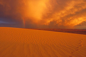
Desert
A desert is a landscape or region that receives an extremely low amount of precipitation, less than enough to support growth of most plants. Most deserts have an average annual precipitation of less than...
and sagebrush steppe located in south central Wyoming
Wyoming
Wyoming is a state in the mountain region of the Western United States. The western two thirds of the state is covered mostly with the mountain ranges and rangelands in the foothills of the Eastern Rocky Mountains, while the eastern third of the state is high elevation prairie known as the High...
, comprising approximately 9,320 square miles (24,000 km²). Among the natural features in the Red Desert region are the Great Divide Basin
Great Divide Basin
The Great Divide Basin is a drainage basin of the Continental Divide of the Americas. The basin is between the Green River watershed on the west and the Medicine Bow River watershed on the east . From the northwest, the basin begins in the "Wind River Range .....
, a unique endorheic drainage basin
Drainage basin
A drainage basin is an extent or an area of land where surface water from rain and melting snow or ice converges to a single point, usually the exit of the basin, where the waters join another waterbody, such as a river, lake, reservoir, estuary, wetland, sea, or ocean...
formed by a division in the Continental Divide
Continental Divide
The Continental Divide of the Americas, or merely the Continental Gulf of Division or Great Divide, is the name given to the principal, and largely mountainous, hydrological divide of the Americas that separates the watersheds that drain into the Pacific Ocean from those river systems that drain...
, and the Killpecker Sand Dunes, the largest living dune system in the United States. In the 19th century, the Oregon
Oregon Trail
The Oregon Trail is a historic east-west wagon route that connected the Missouri River to valleys in Oregon and locations in between.After 1840 steam-powered riverboats and steamboats traversing up and down the Ohio, Mississippi and Missouri rivers sped settlement and development in the flat...
, California
California Trail
The California Trail was an emigrant trail of about across the western half of the North American continent from Missouri River towns to what is now the state of California...
and Mormon
Mormon Trail
The Mormon Trail or Mormon Pioneer Trail is the 1,300 mile route that members of The Church of Jesus Christ of Latter-day Saints traveled from 1846 to 1868...
Trails tracked through the northern and western regions of the Red Desert after crossing the Continental Divide
Continental Divide
The Continental Divide of the Americas, or merely the Continental Gulf of Division or Great Divide, is the name given to the principal, and largely mountainous, hydrological divide of the Americas that separates the watersheds that drain into the Pacific Ocean from those river systems that drain...
at South Pass
South Pass
South Pass is two mountain passes on the Continental Divide in the Rocky Mountains in southwestern Wyoming. The passes are located in a broad low region, 35 miles broad, between the Wind River Range to the north and the Oregon Buttes and Great Divide Basin to the south, in southwestern Fremont...
. Today, busy Interstate 80
Interstate 80
Interstate 80 is the second-longest Interstate Highway in the United States, following Interstate 90. It is a transcontinental artery running from downtown San Francisco, California to Teaneck, New Jersey in the New York City Metropolitan Area...
bisects the desert's southern region while a spider web of gas field roads probe the farthest reaches of the desert.
The majority of the Red Desert is public land managed by the Rock Springs
Rock Springs, Wyoming
Rock Springs is a city in Sweetwater County, Wyoming, United States. The population was 18,708 at the 2000 census. Rock Springs is the principal city of the Rock Springs micropolitan statistical area, which has a population of 37,975....
and Rawlins
Rawlins, Wyoming
Rawlins is a city in Carbon County, Wyoming, United States. The population was 8,538 at the 2000 census. It is the county seat of Carbon County...
field offices of the U.S. Bureau of Land Management
Bureau of Land Management
The Bureau of Land Management is an agency within the United States Department of the Interior which administers America's public lands, totaling approximately , or one-eighth of the landmass of the country. The BLM also manages of subsurface mineral estate underlying federal, state and private...
(BLM). The region is rich in oil
Oil
An oil is any substance that is liquid at ambient temperatures and does not mix with water but may mix with other oils and organic solvents. This general definition includes vegetable oils, volatile essential oils, petrochemical oils, and synthetic oils....
, natural gas
Natural gas
Natural gas is a naturally occurring gas mixture consisting primarily of methane, typically with 0–20% higher hydrocarbons . It is found associated with other hydrocarbon fuel, in coal beds, as methane clathrates, and is an important fuel source and a major feedstock for fertilizers.Most natural...
, uranium
Uranium
Uranium is a silvery-white metallic chemical element in the actinide series of the periodic table, with atomic number 92. It is assigned the chemical symbol U. A uranium atom has 92 protons and 92 electrons, of which 6 are valence electrons...
, coal
Coal
Coal is a combustible black or brownish-black sedimentary rock usually occurring in rock strata in layers or veins called coal beds or coal seams. The harder forms, such as anthracite coal, can be regarded as metamorphic rock because of later exposure to elevated temperature and pressure...
and trona
Trona
Trona ; Na3•2H2O is an evaporite mineral. It is mined as the primary source of sodium carbonate in the United States, where it has replaced the Solvay process used in most of the rest of the world for sodium carbonate production.- Etymology :The word "trona" comes to English by way of either...
. An estimated 84% of the Red Desert has been "industrialized" by oil and gas drilling or by mining operations and associated roads.
The Red Desert supports an abundance of wildlife, despite its scarcity of water and vegetation. The largest migratory herd of pronghorn in the lower 48 states and a rare desert elk herd, said to the be world's largest, live in the desert. Ponds fed by summer snowmelt attract a wide range of migratory birds such as ducks, trumpeter swans, snowbirds, and white pelicans. Herds of feral horses known for their long manes and tails roam the area in large numbers, despite roundups and population control efforts by the BLM. The Hayden Expedition (1871) said Bighorn Sheep were numerous during their stay at the Honeycomb Buttes in the Red Desert, but today wild sheep are only found high in the mountain ranges and are rarely seen. Bison were also common and their skulls and horns can occasionally be found there.
Water

Lake Gosiute began to fill the Red Desert for the first time in the early Eocene Epoch. Subsequent climate and tectonic activities during the lake's lifespan of 4 million years saw repeated patterns of rising and falling water levels. Gosiute reached its maximum surface area of 15000 square miles (38,849.8 km²) with its shoreline stretching into Utah. Other times the lake evaporated completely.
Lake Gosiute left behind a high concentration of saline materials and a deep primal ooze of organic matter. The former produced today's highly-valued mineral trona
Trona
Trona ; Na3•2H2O is an evaporite mineral. It is mined as the primary source of sodium carbonate in the United States, where it has replaced the Solvay process used in most of the rest of the world for sodium carbonate production.- Etymology :The word "trona" comes to English by way of either...
, while the latter created coal-bed methane gas, coal
Coal
Coal is a combustible black or brownish-black sedimentary rock usually occurring in rock strata in layers or veins called coal beds or coal seams. The harder forms, such as anthracite coal, can be regarded as metamorphic rock because of later exposure to elevated temperature and pressure...
, and the world's largest known oil-shale deposit. Energy sources have made the region the epicenter of today's natural gas
Natural gas
Natural gas is a naturally occurring gas mixture consisting primarily of methane, typically with 0–20% higher hydrocarbons . It is found associated with other hydrocarbon fuel, in coal beds, as methane clathrates, and is an important fuel source and a major feedstock for fertilizers.Most natural...
boom in Wyoming.
The contemporary Red Desert watershed includes saline lakes and ponds that feature mud flats during wet years and salt pans in droughts. Intermittent streams dependent primarily upon mountain snowmelt but accelerated by summer thundershowers cut arroyos throughout the basin. Such small earth moving events repeated over the eons combined with the sculpting forces of wind have created the rugged landscape of buttes, pinnacles, gulches, and flats that characterize the Red Desert.
The Continental Divide
Continental Divide
The Continental Divide of the Americas, or merely the Continental Gulf of Division or Great Divide, is the name given to the principal, and largely mountainous, hydrological divide of the Americas that separates the watersheds that drain into the Pacific Ocean from those river systems that drain...
branches to the desert's northwest and rejoins in the southeast, creating the Great Divide Basin
Great Divide Basin
The Great Divide Basin is a drainage basin of the Continental Divide of the Americas. The basin is between the Green River watershed on the west and the Medicine Bow River watershed on the east . From the northwest, the basin begins in the "Wind River Range .....
from which no surface water drains. Steamboat Mountain and other desert mesas or buttes provide seeps and springs that serve as a water source for small streams such as Jack Morrow Creek. While the basin's interior waters are intermittent, the desert is bounded to the west by the Green River
Green River (Utah)
The Green River, located in the western United States, is the chief tributary of the Colorado River. The watershed of the river, known as the Green River Basin, covers parts of Wyoming, Utah, and Colorado. The Green River is long, beginning in the Wind River Mountains of Wyoming and flowing...
and to the east by the North Platte River
North Platte River
The North Platte River is a major tributary of the Platte River and is approximately long counting its many curves, It travels about distance. Its course lies in the U.S...
.
If settlers in the Red Desert such as the Mennonites who named Eden, Wyoming
Eden, Wyoming
Eden is a census-designated place in Sweetwater County, Wyoming, United States. The population was 388 at the 2000 census.-Geography:Eden is located at ....
, were expecting rain follows the plow, (a popular nineteenth century myth that plowed earth would generate rain) they were sorely disappointed. Instead of a Promised Land, they found hard, brown desert ground that averages eight inches of precipitation a year. Most of that is snow. Fierce, seemingly endless western winds were sure to quickly evaporate any rain that does fall during the summer.
Farmers throughout the dry American West had to learn dry-land farming if they were to survive. This often meant relying upon irrigation to turn water upon the land. Efforts to reclaim areas of the Red Desert near Eden for agriculture date back at least to 1886 when Wyoming Territory issued water permits for settlers to divert the Big Sandy Creek, which drains to the Green River. Eden Irrigation and Land Company industrialized irrigation in 1907. The large scale water development project financed by John M. Farson, Sons & Company built a series of dikes on the Little Sandy and Big Sandy Creeks. Boosters for the company seeking to attract settlers distributed pamphlets trumpeting the desert as a land where "fruit orchards will thrive and corn will grow higher than a man's head" and "the growing season in Eden Valley is as delightful as can be found in the country anywhere."
Today two earth dams and 21 miles (33.8 km) of canals with 91 miles (146.4 km) of lateral waterways provide water to irrigate 17010 acres (68.8 km²) under the authority of the Eden Valley Irrigation and Drainage District. Eden Valley irrigation diverts water that naturally flows to the Green River. The Green is the largest tributary of the Colorado River
Colorado River
The Colorado River , is a river in the Southwestern United States and northwestern Mexico, approximately long, draining a part of the arid regions on the western slope of the Rocky Mountains. The watershed of the Colorado River covers in parts of seven U.S. states and two Mexican states...
, which drains to Mexico's Sea of Cortez.
The U.S. Army Corp of Engineers is poised to launch an environmental impact statement of regarding a proposed pipeline 560 miles (901.2 km) long to divert water from the Green River to population centers near Denver, Colorado
Denver, Colorado
The City and County of Denver is the capital and the most populous city of the U.S. state of Colorado. Denver is a consolidated city-county, located in the South Platte River Valley on the western edge of the High Plains just east of the Front Range of the Rocky Mountains...
. The $4 billion project targets a route east from Flaming Gorge Reservoir across the Red Desert to Laramie
Laramie, Wyoming
Laramie is a city in and the county seat of Albany County, Wyoming, United States. The population was 30,816 at the . Located on the Laramie River in southeastern Wyoming, the city is west of Cheyenne, at the junction of Interstate 80 and U.S. Route 287....
and then south to the Colorado
Colorado
Colorado is a U.S. state that encompasses much of the Rocky Mountains as well as the northeastern portion of the Colorado Plateau and the western edge of the Great Plains...
Front Range.
Killpecker Sand Dunes
Killpecker Sand Dunes stretch 55 miles (88.5 km) east from the Green River Basin across the Continental Divide into the Great Divide Basin and encompass approximately 109000 acres (441.1 km²). These living dunes, one of North America's largest fields, owe their presence to two key factors:- The Big Sandy and Little Sandy Rivers northeast of Rock Springs, WyomingRock Springs, WyomingRock Springs is a city in Sweetwater County, Wyoming, United States. The population was 18,708 at the 2000 census. Rock Springs is the principal city of the Rock Springs micropolitan statistical area, which has a population of 37,975....
where large volumes of sand accumulated on their banks during glacial melting from the Wind River Mountains. - Westerly winds that during the past 20,000 years have moved the sand eastward across the continental divide to its present location.
A vital function of the dune fields is storing snowmelt and rain which support vegetation and wildlife. Water percolates deep into sand where it is safe from evaporating winds and sun. Such water is stored for access by basin large sagebrush and other vegetation depending upon the dunes' degree of stabilization. The few plant species that can survive on the active dunes include:
- Blowout grassBlowout grassBlowout grass, Redfieldia flexuosa, is a grass that can be found on sand dunes. The plants grow in small clusters, protecting each other from the harsh desert conditions.-Range:...
, Indian rice grass, needle-and-thread grass, prairie sandweed, rusty lupine, salina wildrye, sand lovegrass, sand muhly, sandhill muhly, and scurfpea.
Such plants help stabilize the sand by slightly reducing ground-level wind velocity. Stabilization is a cumulative process. Eventually the dunes may become stable as plant cover increases—assuming disruptive forces such as drought, fire, livestock and human traffic are not present.
Dune beetles and other insects in addition to small mammals such as shrews, white-footed mice and kangaroo rats inhabit the dunes. Their presence attracts owls, eagles, bobcats and other predators. Moreover, an oasis of short-lived summer ponds that occur in swales at the base of the dunes support migratory shore birds and waders, as well as large game animals such as elk. Cattle, sheep, and free roaming wild horses also frequent the ponds. The fresh water also provides a habitat for aquatic organism such as salamanders and freshwater shrimp.
Active sand dunes within the 10500 acres (42.5 km²) of the Killpecker Sand Dunes area are open to off-road vehicles. Motorists are required to avoid the fresh water ponds scattered throughout the dunes.
Plant and wildlife
At first glance the Red Desert's largely dry, barren landscape seems an unlikely location for some 350 wildlife species and more than 1,000 plant species. The desert's sagebrush steppe and clump grass habitat support 40,000 to 50,000 pronghorns (the largest migratory herd in the lower 48 states), similar sized herds of mule deer and the world's largest desert elk herd.What the desert lacks in concentrated animal habitat, it makes up in expanse. The Red Desert is home to the largest unfenced area in the continental United States. Nearly three-quarters of the area is covered by sagebrush grassland.
The dominance of the region's evergreen sagebrush is a critical habitat for a variety of wildlife ranging from pronghorn which browse its leaves year round to small insects. However, habitat is constrained by oil and gas roads along with drilling and mining. Sagebrush also provides cover for animals such as elk and the pygmy rabbit. Elk depend upon tall brush near Steamboat Mountain for shelter during spring calving season and elsewhere for shade during the heat of summer. Yet the broader impact of sagebrush upon the ecology is its function as a living snow fence
Snow fence
A snow fence is a structure, similar to a sand fence, that forces drifting snow to accumulate in a desired place. They are primarily employed to minimize the amount of snowdrift on roadways and railways. Farmers and ranchers may use temporary snow fences to create large drifts in basins for a...
. Windblown snow builds up on the lee side of the brush during winter. This effectively stores moisture that is released into the soil in late spring and early summer.
The result of the Red Desert's unique ecology is that wildlife is varied. Predators such as coyotes and the occasional mountain lion, grey wolf, swift fox, and kit fox are attracted by the area's mammals for feed. Pocket gophers, badgers, sage grouse, sage sparrows, and the sage thrasher are associated with the sagebrush habitat. The Red Desert is home to a range of burrowing animals. The white-tailed prairie dog, Great Basin spadefoot toad, tiger salamander, pygmy rabbits, and sagebrush lizards all go underground for protection from the desert's extreme weather and predators. Similarly, the burrowing owl nests and roosts underground, typically in burrows dug by prairie dogs. Migratory summer birds such as the white-faced ibis, trumpeter swan, and white pelican are found at snowmelt ponds on the desert floor and at temporal wetlands.
High above the desert floor, the Ferris Mountains and Green Mountains rim the Red Desert to the northeast. The mountains' boreal environment reaches as high as 10037 feet (3,059.3 m), in the case of Ferris Peak, and supports snowshoe hares, red squirrels, and pockets of big horn sheep. The high elevation with its cooler summer range attracts elk and mule deer. Prairie falcons, northern harriers and other raptors soar along mountain ridges and canyon rims looking for feed such as migratory mountain plovers, a small ground bird.
The mountain plover is one of three species protected by the Endangered Species Act present in the Red Desert. The bald eagle and the black-footed ferret are also listed. However, the bald eagle is seldom seen in the desert because of the lack of streams or lakes with accompanying fish. Black-footed ferrets, which feed upon prairie dogs, are also rare.
Cultural and economic landscape
Scientists trace the story of human presence in the Red Desert back 12,000 years. Striking evidence of early human inhabitants is seen in rock art found at the Boar's Tusk, Seedskadee, and East Flaming Gorge areas. Researchers interpret the petroglyphs carved into rock at these sites as biographical, ceremonial, or spiritual expressions. The Red Desert's Black Art petrogylph is thought to date back 11,500 years, according to anthropologist and cultural historian Russell L. Tanner who says the rock art may be the continent's oldest.Tanner refers to the Red Desert as a marketplace and crossroads during more recent times of interaction between nomadic Plains Indians, including Shoshone, Crows, and Blackfeet. He writes that rock art of the times, especially along the Green River, sprang from a melding of Indian cultures represented by imagery of the Plains Indian warrior tradition. Other pre-historic evidence include native American artifacts estimated to be more than 10,000 years old found in the Killpecker Sand Dunes, often in company with bison bones.
Generations of American families beginning in the 1840s also left their mark upon the desert as they migrated westward along emigrant trails. The environmental impact of an estimated 350,000 pioneers and their wagon trains traveling through Wyoming between 1841 and 1868 is still visible today. In some cases, such as at Guernsey
Guernsey, Wyoming
Guernsey is a town in Platte County, Wyoming, United States. The population was 1,147 at the 2000 census.-Geography:Guernsey is located at ....
, wagon wheels wore ruts deep into solid sandstone. However, most trail ruts are less dramatic but still evidence of a people's history worn into the earth.
A westward-looking nation in 1869 united its eastern and western shores with the First Transcontinental Railroad
First Transcontinental Railroad
The First Transcontinental Railroad was a railroad line built in the United States of America between 1863 and 1869 by the Central Pacific Railroad of California and the Union Pacific Railroad that connected its statutory Eastern terminus at Council Bluffs, Iowa/Omaha, Nebraska The First...
whose route traversed the Red Desert. University of Wyoming
University of Wyoming
The University of Wyoming is a land-grant university located in Laramie, Wyoming, situated on Wyoming's high Laramie Plains, at an elevation of 7,200 feet , between the Laramie and Snowy Range mountains. It is known as UW to people close to the university...
historian Phil Roberts described the notion of building a transcontinental railroad as "today's equivalent of the mission to Mars: Big, expensive and impossible". The preliminary survey for the railroad produced the first map of the Great Basin and Southern Wyoming, according to author Stephen E. Ambrose. The Red Desert's lack of water presented a problem for steam locomotives of the time. The Union Pacific Company found reliable water by drilling deep artesian wells in the desert. Some of these railroad wells, such as at Wamsutter
Wamsutter, Wyoming
Wamsutter is a town in Sweetwater County, Wyoming, United States. The population was 261 at the 2000 census.The original inhabitants of the area were the Shoshone and Ute tribes. Westerners did not really settle in the county until the coming of the railroad in the 1860s. Originally, the town was...
continue to supply much needed water today for residents and the influx of transitory oil-patch workers who live in temporary housing or "man camps".
The Union Pacific Railroad helped launch western towns along its route like Wamsutter. Beginning in 1913, the Lincoln Highway
Lincoln Highway
The Lincoln Highway was the first road across the United States of America.Conceived and promoted by entrepreneur Carl G. Fisher, the Lincoln Highway spanned coast-to-coast from Times Square in New York City to Lincoln Park in San Francisco, originally through 13 states: New York, New Jersey,...
connected them. The Lincoln Highway's coast-to-coast route also cut across the Red Desert as it passed through Wyoming. Interstate 80
Interstate 80
Interstate 80 is the second-longest Interstate Highway in the United States, following Interstate 90. It is a transcontinental artery running from downtown San Francisco, California to Teaneck, New Jersey in the New York City Metropolitan Area...
, nearly a half century later in 1956, replaced the Lincoln Highway as America's premier continental roadway. Today, Interstate 80 carries an estimated 11,000 vehicles across the desert daily. The four-lane highway slices the desert into a north and south Red Desert in terms of wildlife migration.
Historic trails used by nineteenth century stagecoaches are also part of the Red Desert's legacy. Of particular note, the Overland Stage initially followed the Platte River and the Oregon Trail to South Pass, but later shifted to a route across southern Wyoming. Stagecoach ruts in the desert are still visible in a variety of locations including north of Baggs
Baggs, Wyoming
Baggs is a town in Carbon County, Wyoming, United States. The population was 348 at the 2000 census.-Geography:Baggs is located at ....
. A short-lived gold rush in the Red Desert's mountains to the north beginning in 1867 led to stage and freight service from Point of Rocks on the Union Pacific Railroad north to South Pass City
South Pass City, Wyoming
South Pass City is an unincorporated community in Fremont County, Wyoming, United States. It is located 2 miles south of the intersection of highways 28 and 131. The closest town is Atlantic City...
.
Frontier expansion after the railroad's completion spurred new trade routes such as the New Fork Wagon Road that ran 80 miles (128.7 km) from Rock Springs, Wyoming
Rock Springs, Wyoming
Rock Springs is a city in Sweetwater County, Wyoming, United States. The population was 18,708 at the 2000 census. Rock Springs is the principal city of the Rock Springs micropolitan statistical area, which has a population of 37,975....
to New Fork
New Fork, Wyoming
New Fork is a ghost town in Sublette County, Wyoming, United States, near Boulder. It was one of the earliest settlements in the upper Green River valley. New Fork was established in 1888 by John Vible and Louis Broderson, Danish immigrants who had arrived in the United States in 1884. They...
. The New Fork Wagon Road connected isolated ranchers and settlements in northern Sweetwater and eastern Sublette Counties. The volume of cargo is evidenced by freighters of the time who were known to hitch as many as 18 horses to haul five freight wagons at once.
Other Expansion Era roads branched off from Union Pacific railheads at Point of Rocks, Green River and Bryan. These trade routes linked remote mining, ranching, and military settlements. Signs of these early trade routes, such as stage stations and freighter camps, are still visible in areas such as Freighter's Gap.
Roadways used by modern-day freighters hauling oilfield supplies have created a spider web of dirt and gravel roads that crisscross the far reaches of the desert. BP, an energy company, reports service people associated with the Wamsutter gas field travel 800000 miles (1,287,472 km) per month, down from 1000000 miles (1,609,340 km). The explosion of natural gas wells drilled during Wyoming's most recent energy industry boom continues with more than 2,000 projected wells in the Wamsutter gas field to be operational by 2020. The gas field encompasses an area in the Red Desert about 55 miles (88.5 km) long and 35 miles (56.3 km) wide. Advances in drilling technology now allow grouping of multiple wells on a single drilling pad, thus reducing the footprint upon the land. Meanwhile, BLM expects the expansion in energy development to continue in the Red Desert including the Jack Morrow Hills of 600000 acres (2,428.1 km²) near South Pass
South Pass
South Pass is two mountain passes on the Continental Divide in the Rocky Mountains in southwestern Wyoming. The passes are located in a broad low region, 35 miles broad, between the Wind River Range to the north and the Oregon Buttes and Great Divide Basin to the south, in southwestern Fremont...
.