
Historic regions of the United States
Encyclopedia
United States
The United States of America is a federal constitutional republic comprising fifty states and a federal district...
.
Colonial era (before 1776)
The Thirteen Colonies
- Connecticut ColonyConnecticut ColonyThe Connecticut Colony or Colony of Connecticut was an English colony located in British America that became the U.S. state of Connecticut. Originally known as the River Colony, it was organized on March 3, 1636 as a haven for Puritan noblemen. After early struggles with the Dutch, the English...
- Delaware ColonyDelaware ColonyDelaware Colony in the North American Middle Colonies was a region of the Province of Pennsylvania although never legally a separate colony. From 1682 until 1776 it was part of the Penn proprietorship and was known as the lower counties...
- Province of GeorgiaProvince of GeorgiaThe Province of Georgia was one of the Southern colonies in British America. It was the last of the thirteen original colonies established by Great Britain in what later became the United States...
- Province of MarylandProvince of MarylandThe Province of Maryland was an English and later British colony in North America that existed from 1632 until 1776, when it joined the other twelve of the Thirteen Colonies in rebellion against Great Britain and became the U.S...
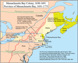
- Province of Massachusetts BayProvince of Massachusetts BayThe Province of Massachusetts Bay was a crown colony in North America. It was chartered on October 7, 1691 by William and Mary, the joint monarchs of the kingdoms of England and Scotland...
- Province of New HampshireProvince of New HampshireThe Province of New Hampshire is a name first given in 1629 to the territory between the Merrimack and Piscataqua rivers on the eastern coast of North America. It was formally organized as an English royal colony on October 7, 1691, during the period of English colonization...
- Province of New JerseyProvince of New JerseyThe Province of New Jersey was one of the Middle Colonies of Colonial America and became the U.S. state of New Jersey in 1776. The province had originally been settled by Europeans as part of New Netherland, but came under English rule after the surrender of Fort Amsterdam in 1664, becoming a...
- Province of New YorkProvince of New YorkThe Province of New York was an English and later British crown territory that originally included all of the present U.S. states of New York, New Jersey, Delaware and Vermont, along with inland portions of Connecticut, Massachusetts, and Maine, as well as eastern Pennsylvania...
- Province of North CarolinaProvince of North CarolinaThe Province of North Carolina was originally part of the Province of Carolina in British America, which was chartered by eight Lords Proprietor. The province later became the U.S. states of North Carolina and Tennessee....
- Colony of Rhode Island and Providence PlantationsColony of Rhode Island and Providence PlantationsThe Colony of Rhode Island and Providence Plantations was one of the original English Thirteen Colonies established on the east coast of North America that, after the American Revolution, became the modern U.S...
- Province of PennsylvaniaProvince of PennsylvaniaThe Province of Pennsylvania, also known as Pennsylvania Colony, was founded in British America by William Penn on March 4, 1681 as dictated in a royal charter granted by King Charles II...
- Province of South CarolinaProvince of South CarolinaThe South Carolina Colony, or Province of South Carolina, was originally part of the Province of Carolina, which was chartered in 1663. The colony later became the U.S. state of South Carolina....
- Colony and Dominion of Virginia
Pre-Revolutionary War settlements, districts and other regions
{* -indicates failed legal entities}New England region
- Dominion of New EnglandDominion of New EnglandThe Dominion of New England in America was an administrative union of English colonies in the New England region of North America. The dominion was ultimately a failure because the area it encompassed was too large for a single governor to manage...
* - Equivalent landsEquivalent landsThe Equivalent lands were several large tracts of land that the Province of Massachusetts Bay made available to settlers from the Connecticut Colony after April, 1716. This was done as compensation for an "equivalent" area of Connecticut-claimed territory which had been inadvertently settled by...
- King's College TractKing's College TractThe King's College Tract consisted of an area of forested land in the vicinity of the present towns of Cambridge and Johnson in the U.S. state of Vermont. The tract was granted in 1764 by Lieutenant Governor Cadwallader Colden of the New York crown colony, in the name of King George III to the...
- Province(s) of MaineProvince of MaineThe Province of Maine refers to several English colonies of that name that existed in the 17th century along the northeast coast of North America, at times roughly encompassing portions of the present-day U.S. states of Maine, New Hampshire, and Vermont, as well as the Canadian provinces of Quebec...
*- Popham ColonyPopham ColonyThe Popham Colony was a short-lived English colonial settlement in North America that was founded in 1607 and located in the present-day town of Phippsburg, Maine near the mouth of the Kennebec River by the proprietary Virginia Company of Plymouth...
(or Sagadahoc Colony)* - Gorges-Mason Grant*
- Mason LandsProvince of New HampshireThe Province of New Hampshire is a name first given in 1629 to the territory between the Merrimack and Piscataqua rivers on the eastern coast of North America. It was formally organized as an English royal colony on October 7, 1691, during the period of English colonization...
- Gorges Patent*
- Lygonia PatentLygoniaLygonia was a proprietary province in pre-colonial Maine, created through a grant from the Plymouth Council for New England in 1630 to lands then under control of Sir Ferdinando Gorges. The grant was named for his mother, Cicely Gorges...
* - New Somersetshire*
- Lygonia Patent
- Muscongus PatentWaldo PatentThe Waldo Patent, a letters patent also known as the Muscongus Patent or the Lincolnshire Patent, was an area of land 36 miles square in what is now the U.S...
(also known as the Waldo Patent and, eventually, the Bingham PurchaseBingham PurchaseThe Bingham Purchase refers to several tracts of land in the U.S. state of Maine, formerly owned by William Bingham.These lands were granted to early colonizers in the 1630s, and became part of the larger Waldo Patent, named after Samuel Waldo, who acquired the land grants in 1720...
)
- Popham Colony
- Massachusetts Bay ColonyMassachusetts Bay ColonyThe Massachusetts Bay Colony was an English settlement on the east coast of North America in the 17th century, in New England, situated around the present-day cities of Salem and Boston. The territory administered by the colony included much of present-day central New England, including portions...
- Narragansett CountryWashington County, Rhode IslandWashington County, commonly known colloquially as South County, is a county located in the southwestern part of the U.S. state of Rhode Island. Washington County borders Kent County to the north, New London County in Connecticut to the west, Suffolk County in New York to the southwest, the Atlantic...
*
- Narragansett Country
- The New Hampshire GrantsNew Hampshire GrantsThe New Hampshire Grants or Benning Wentworth Grants were land grants made between 1749 and 1764 by the provincial governor of New Hampshire, Benning Wentworth. The land grants, totaling about 135 , were made on land claimed by New Hampshire west of the Connecticut River, territory that was also...
- New Haven ColonyNew Haven ColonyThe New Haven Colony was an English colonial venture in present-day Connecticut in North America from 1637 to 1662.- Quinnipiac Colony :A Puritan minister named John Davenport led his flock from exile in the Netherlands back to England and finally to America in the spring of 1637...
- Plymouth ColonyPlymouth ColonyPlymouth Colony was an English colonial venture in North America from 1620 to 1691. The first settlement of the Plymouth Colony was at New Plymouth, a location previously surveyed and named by Captain John Smith. The settlement, which served as the capital of the colony, is today the modern town...
- Saybrook ColonySaybrook ColonyThe Saybrook Colony was established in late 1635 at the mouth of the Connecticut River in present day Old Saybrook, Connecticut by John Winthrop, the Younger, son of John Winthrop, the Governor of Massachusetts. The former was designated Governor by the original settlers which included Colonel...
- Wessagusset ColonyWessagusset ColonyWessagusset Colony was a short-lived English trading colony in New England located in present-day Weymouth, Massachusetts. It was settled in August 1622 by between fifty and sixty colonists who were ill-prepared for colonial life...
*
Mid-Atlantic region
- Granville DistrictGranville DistrictThe Granville District was a 60-mile wide strip of land in the North Carolina colony adjoining the boundary with Virginia, lying between north latitudes 35° 34' and 36° 30'....
- East JerseyEast JerseyThe Province of East Jersey and the Province of West Jersey were two distinct, separately governed parts of the Province of New Jersey that existed as separate provinces for 28 years, between 1674 and 1702. East Jersey's capital was located at Perth Amboy...
- West JerseyWest JerseyWest Jersey and East Jersey were two distinct parts of the Province of New Jersey. The political division existed for 28 years, between 1674 and 1702...
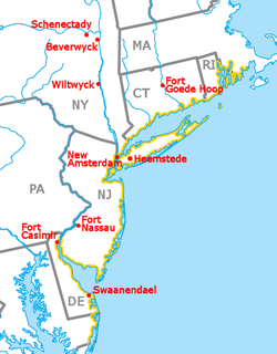
- New NetherlandNew NetherlandNew Netherland, or Nieuw-Nederland in Dutch, was the 17th-century colonial province of the Republic of the Seven United Netherlands on the East Coast of North America. The claimed territories were the lands from the Delmarva Peninsula to extreme southwestern Cape Cod...
and its settlementsNew Netherland settlementsNew Netherland, or Nieuw-Nederland in Dutch, was the 17th century colonial province of the Republic of the Seven United Netherlands on northeastern coast of North America. The claimed territory were the lands from the Delmarva Peninsula to southern Cape Cod. Settled areas are now part of... - New SwedenNew SwedenNew Sweden was a Swedish colony along the Delaware River on the Mid-Atlantic coast of North America from 1638 to 1655. Fort Christina, now in Wilmington, Delaware, was the first settlement. New Sweden included parts of the present-day American states of Delaware, New Jersey, and Pennsylvania....
*
Southern region
- Province of CarolinaProvince of CarolinaThe Province of Carolina, originally chartered in 1629, was an English and later British colony of North America. Because the original Heath charter was unrealized and was ruled invalid, a new charter was issued to a group of eight English noblemen, the Lords Proprietors, in 1663...
- Fort CarolineFort CarolineFort Caroline was the first French colony in the present-day United States. Established in what is now Jacksonville, Florida, on June 22, 1564, under the leadership of René Goulaine de Laudonnière, it was intended as a refuge for the Huguenots. It lasted one year before being obliterated by the...
* - CharlesfortCharlesfort-Santa Elena SiteCharlesfort-Santa Elena Site is an archeological site on Parris Island, South Carolina, which is also known as Ribaut Monument, San Marcos, San Felipe, or 38BU51 and 38BU162...
* - La FloridaSpanish FloridaSpanish Florida refers to the Spanish territory of Florida, which formed part of the Captaincy General of Cuba, the Viceroyalty of New Spain, and the Spanish Empire. Originally extending over what is now the southeastern United States, but with no defined boundaries, la Florida was a component of...
- San AgustínSt. Augustine, FloridaSt. Augustine is a city in the northeast section of Florida and the county seat of St. Johns County, Florida, United States. Founded in 1565 by Spanish explorer and admiral Pedro Menéndez de Avilés, it is the oldest continuously occupied European-established city and port in the continental United...
(or St. Augustine) - San Miguel de GualdapeSan Miguel de GualdapeSan Miguel de Gualdape was the first European settlement inside what is now United States territory, founded by Spaniard Lucas Vázquez de Ayllón in 1526. It was to last only three months of winter before being abandoned in early 1527....
* - Mocama Province*
- San Agustín
- JamestownJamestown, VirginiaJamestown was a settlement in the Colony of Virginia. Established by the Virginia Company of London as "James Fort" on May 14, 1607 , it was the first permanent English settlement in what is now the United States, following several earlier failed attempts, including the Lost Colony of Roanoke...
- Northern Neck Proprietary (or "Fairfax Grant")
- The Lost Colony of RoanokeRoanoke ColonyThe Roanoke Colony on Roanoke Island in Dare County, present-day North Carolina, United States was a late 16th-century attempt to establish a permanent English settlement in what later became the Virginia Colony. The enterprise was financed and organized by Sir Walter Raleigh and carried out by...
* - Stuarts TownScottish colonization of the AmericasScottish colonization of the Americas consisted of a number of failed or abandoned Scottish settlements in North America, a colony at Darien, Panama, and a number of wholly or largely Scottish settlements made after the Acts of Union 1707, and those made by the enforced resettlement after the...
*
Southwestern region
- Louisiana
- LouisianeLouisiana (New France)Louisiana or French Louisiana was an administrative district of New France. Under French control from 1682–1763 and 1800–03, the area was named in honor of Louis XIV, by French explorer René-Robert Cavelier, Sieur de la Salle...
- Arkansas PostArkansas Post National MemorialArkansas Post National Memorial, located about 8 miles southeast of Gillett, Arkansas, commemorates key events related to European-American history that occurred on site and in the vicinity: the trading post was the first successful French settlement in the Lower Mississippi River Valley ; site...
- The German CoastGerman CoastThe German Coast was a region of early Louisiana settlement located above New Orleans on the Mississippi River – specifically, from east to west, in St. Charles, St. John the Baptist, and St. James parishes of present-day Acadiana. The four settlements along the coast were Karlstein, Hoffen,...
; 1731
- Arkansas Post
- LuisianaLouisiana (New Spain)Louisiana was the name of an administrative district of the Viceroyalty of New Spain from 1764 to 1803 that represented territory west of the Mississippi River basin, plus New Orleans...
- Louisiane
- TejasSpanish TexasSpanish Texas was one of the interior provinces of New Spain from 1690 until 1821. Although Spain claimed ownership of the territory, which comprised part of modern-day Texas, including the land north of the Medina and Nueces Rivers, the Spanish did not attempt to colonize the area until after...
- Fort Saint Louis*
- Santa Fé de Nuevo Méjico
Interior
- District of West AugustaDistrict of West AugustaThe District of West Augusta was a short-lived historical region of Colonial Virginia that encompassed much of what is now northern West Virginia and southwestern Pennsylvania.-History:...
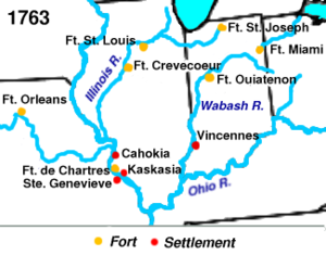
- Illinois CountryIllinois CountryThe Illinois Country , also known as Upper Louisiana, was a region in what is now the Midwestern United States that was explored and settled by the French during the 17th and 18th centuries. The terms referred to the entire Upper Mississippi River watershed, though settlement was concentrated in...
- Indiana Company
- The Indian ReserveIndian Reserve (1763)The Indian Reserve was a territory under British rule in North America set aside in the Royal Proclamation of 1763 for use by American Indians between 1763 and 1783....
- Ohio CountryOhio CompanyThe Ohio Company, formally known as the Ohio Company of Virginia, was a land speculation company organized for the settlement by Virginians of the Ohio Country and to trade with the Indians there...
(or The Ohio Company of Virginia)*
Colonies settled but unrecognized

- TransylvaniaTransylvania (colony)Transylvania, or the Transylvania Colony, was a short-lived, extra-legal colony founded in 1775 by Richard Henderson, who controlled the North Carolina based Transylvania Company, which had reached an agreement to purchase the land from the Cherokee in the "Treaty of Sycamore Shoals"...
* - The Watauga RepublicWatauga AssociationThe Watauga Association was a semi-autonomous government created in 1772 by frontier settlers living along the Watauga River in what is now present day Elizabethton, Tennessee...
Colonies proposed but unrealized
- Charlotina ColonyCharlotinaCharlotina was the suggested name for a popularly proposed British crown colony which was to be established in America following the end of the Seven Years' War, in which Great Britain had acquired a large portion of New France in 1763...
- Mississippi ColonyMississippi Land CompanyThe Mississippi Land Company was a land company formed in 1763 following the British victory in the French and Indian War in North America...
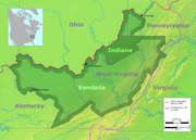
- Vandalia ColonyVandalia (colony)Vandalia was the name of a proposed British colony in North America . The colony was located south of the Ohio River, primarily in what is now the U.S...
(also called "Pittsylvania")
Independent entities later wholly admitted to the union
- Kingdom of HawaiiKingdom of HawaiiThe Kingdom of Hawaii was established during the years 1795 to 1810 with the subjugation of the smaller independent chiefdoms of Oahu, Maui, Molokai, Lānai, Kauai and Niihau by the chiefdom of Hawaii into one unified government...
, later the Republic of HawaiiRepublic of HawaiiThe Republic of Hawaii was the formal name of the government that controlled Hawaii from 1894 to 1898 when it was run as a republic. The republic period occurred between the administration of the Provisional Government of Hawaii which ended on July 4, 1894 and the adoption of the Newlands... - Provisional Territory of OregonProvisional Government of OregonThe Provisional Government of Oregon was a popularly elected government created in the Oregon Country, in the Pacific Northwest region of North America. It existed from May 2, 1843 until March 3, 1849. Created at a time when no country had sovereignty over the region, this independent government...
- Republic of TexasRepublic of TexasThe Republic of Texas was an independent nation in North America, bordering the United States and Mexico, that existed from 1836 to 1846.Formed as a break-away republic from Mexico by the Texas Revolution, the state claimed borders that encompassed an area that included all of the present U.S...
- Independent State of VermontVermont RepublicThe term Vermont Republic has been used by later historians for the government of what became modern Vermont from 1777 to 1791. In July 1777 delegates from 28 towns met and declared independence from jurisdictions and land claims of British colonies in New Hampshire and New York. They also...
(also known as the Republic of New Connecticut)
Regions purchased from foreign powers
- Alaska PurchaseAlaska purchaseThe Alaska Purchase was the acquisition of the Alaska territory by the United States from Russia in 1867 by a treaty ratified by the Senate. The purchase, made at the initiative of United States Secretary of State William H. Seward, gained of new United States territory...
(also called "Seward's Folly"), 1867, from RussiaRussian EmpireThe Russian Empire was a state that existed from 1721 until the Russian Revolution of 1917. It was the successor to the Tsardom of Russia and the predecessor of the Soviet Union...
, for $7,200,000 - Florida Purchase (or the Spanish CessionSpanish CessionThe Spanish Cession includes land that makes up all of present-day Florida, and parts of present-day Louisiana, Mississippi, Colorado, and Alabama. It was given to the United States in the Adams-Onís Treaty of 1819, after Andrew Jackson invaded Spanish forts in Spanish Florida without approval from...
), 1819 (effective 1821), from SpainSpainSpain , officially the Kingdom of Spain languages]] under the European Charter for Regional or Minority Languages. In each of these, Spain's official name is as follows:;;;;;;), is a country and member state of the European Union located in southwestern Europe on the Iberian Peninsula...
, for $5,000,000; included:- East FloridaEast FloridaEast Florida was a colony of Great Britain from 1763–1783 and of Spain from 1783–1822. East Florida was established by the British colonial government in 1763; as its name implies it consisted of the eastern part of the region of Florida, with West Florida comprising the western parts. Its capital...
- West FloridaWest FloridaWest Florida was a region on the north shore of the Gulf of Mexico, which underwent several boundary and sovereignty changes during its history. West Florida was first established in 1763 by the British government; as its name suggests it largely consisted of the western portion of the region...
- Sabine Free StateSabine Free StateThe Neutral Ground was a disputed area between Spanish Texas and the United States' newly acquired Louisiana Purchase...
or Neutral Ground
- East Florida
- Gadsden PurchaseGadsden PurchaseThe Gadsden Purchase is a region of present-day southern Arizona and southwestern New Mexico that was purchased by the United States in a treaty signed by James Gadsden, the American ambassador to Mexico at the time, on December 30, 1853. It was then ratified, with changes, by the U.S...
, 1853, from MexicoMexicoThe United Mexican States , commonly known as Mexico , is a federal constitutional republic in North America. It is bordered on the north by the United States; on the south and west by the Pacific Ocean; on the southeast by Guatemala, Belize, and the Caribbean Sea; and on the east by the Gulf of...
, for $10,000,000 - Louisiana PurchaseLouisiana PurchaseThe Louisiana Purchase was the acquisition by the United States of America of of France's claim to the territory of Louisiana in 1803. The U.S...
, 1803, from FranceFrench First RepublicThe French First Republic was founded on 22 September 1792, by the newly established National Convention. The First Republic lasted until the declaration of the First French Empire in 1804 under Napoleon I...
, for $15,000,000. - Virgin IslandsUnited States Virgin IslandsThe Virgin Islands of the United States are a group of islands in the Caribbean that are an insular area of the United States. The islands are geographically part of the Virgin Islands archipelago and are located in the Leeward Islands of the Lesser Antilles.The U.S...
, 1917, from DenmarkKingdom of DenmarkThe Kingdom of Denmark or the Danish Realm , is a constitutional monarchy and sovereign state consisting of Denmark proper in northern Europe and two autonomous constituent countries, the Faroe Islands in the North Atlantic and Greenland in North America. Denmark is the hegemonial part, where the...
, for $25,000,000
Regions annexed from or ceded by foreign powers
- American SamoaAmerican SamoaAmerican Samoa is an unincorporated territory of the United States located in the South Pacific Ocean, southeast of the sovereign state of Samoa...
; 1899, from GermanyGermanyGermany , officially the Federal Republic of Germany , is a federal parliamentary republic in Europe. The country consists of 16 states while the capital and largest city is Berlin. Germany covers an area of 357,021 km2 and has a largely temperate seasonal climate... - The Aroostock War Compromise LandsWebster-Ashburton TreatyThe Webster–Ashburton Treaty, signed August 9, 1842, was a treaty resolving several border issues between the United States and the British North American colonies...
; 1842, split jointly-claimed areas with the U.K.United Kingdom of Great Britain and IrelandThe United Kingdom of Great Britain and Ireland was the formal name of the United Kingdom during the period when what is now the Republic of Ireland formed a part of it....
- Maine–New Brunswick Border
- Republic of Indian StreamRepublic of Indian StreamThe Republic of Indian Stream was a small, unrecognized, constitutional republic in North America, along the section of the US–Canada border that divides the Canadian province of Quebec from the US state of New Hampshire. It existed from July 9, 1832 to 1835...
- South AcadiaAcadiaAcadia was the name given to lands in a portion of the French colonial empire of New France, in northeastern North America that included parts of eastern Quebec, the Maritime provinces, and modern-day Maine. At the end of the 16th century, France claimed territory stretching as far south as...
- Republic of Indian Stream
- Northwest AngleNorthwest AngleThe Northwest Angle, known simply as the Angle by locals, and coextensive with Angle Township, is a part of northern Lake of the Woods County, Minnesota, and is the only place in the United States outside Alaska that is north of the 49th parallel...
- Rupert's LandRupert's LandRupert's Land, or Prince Rupert's Land, was a territory in British North America, consisting of the Hudson Bay drainage basin that was nominally owned by the Hudson's Bay Company for 200 years from 1670 to 1870, although numerous aboriginal groups lived in the same territory and disputed the...
south of the 49th parallel49th parallel northThe 49th parallel north is a circle of latitude that is 49 degrees north of the Earth's equatorial plane. It crosses Europe, Asia, the Pacific Ocean, North America, and the Atlantic Ocean....
- Maine–New Brunswick Border
- GuamGuamGuam is an organized, unincorporated territory of the United States located in the western Pacific Ocean. It is one of five U.S. territories with an established civilian government. Guam is listed as one of 16 Non-Self-Governing Territories by the Special Committee on Decolonization of the United...
; 1898, from Spain - Mexican CessionMexican CessionThe Mexican Cession of 1848 is a historical name in the United States for the region of the present day southwestern United States that Mexico ceded to the U.S...
; (effective 1848), from Mexico, including:- Alta CaliforniaAlta CaliforniaAlta California was a province and territory in the Viceroyalty of New Spain and later a territory and department in independent Mexico. The territory was created in 1769 out of the northern part of the former province of Las Californias, and consisted of the modern American states of California,...
(California, Nevada, Utah) - Nuevo MexicoSanta Fe de Nuevo MéxicoSanta Fe de Nuevo México was a province of New Spain and later Mexico that existed from the late 16th century up through the mid-19th century. It was centered on the upper valley of the Rio Grande , in an area that included most of the present-day U.S. state of New Mexico...
(New Mexico, Arizona, parts of Texas, Colorado, Oklahoma, Wyoming, Kansas)- Provisional New MexicoU.S. provisional government of New MexicoUnder the provisions of the Kearny Code, the first legislature of New Mexico commenced its session on December 6, 1847. The Council consisted of seven members, with Antonio Sandoval, of Bernalillo County, as president, and the House of twenty-one members, with W.Z...
- Provisional New Mexico
- Alta California
- Northern Mariana IslandsNorthern Mariana IslandsThe Northern Mariana Islands, officially the Commonwealth of the Northern Mariana Islands , is a commonwealth in political union with the United States, occupying a strategic region of the western Pacific Ocean. It consists of 15 islands about three-quarters of the way from Hawaii to the Philippines...
; 1945, from Japan (a U.S. administered United Nations trust territoryTrust Territory of the Pacific IslandsThe Trust Territory of the Pacific Islands was a United Nations trust territory in Micronesia administered by the United States from 1947 to 1986.-History:...
1945-1972; since 1972 a U.S. commonwealthCommonwealthCommonwealth is a traditional English term for a political community founded for the common good. Historically, it has sometimes been synonymous with "republic."More recently it has been used for fraternal associations of some sovereign nations...
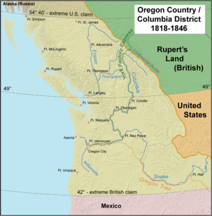
) - Oregon Country (U.S.)Oregon CountryThe Oregon Country was a predominantly American term referring to a disputed ownership region of the Pacific Northwest of North America. The region was occupied by British and French Canadian fur traders from before 1810, and American settlers from the mid-1830s, with its coastal areas north from...
, the 1846 Oregon TreatyOregon TreatyThe Oregon Treaty is a treaty between the United Kingdom and the United States that was signed on June 15, 1846, in Washington, D.C. The treaty brought an end to the Oregon boundary dispute by settling competing American and British claims to the Oregon Country, which had been jointly occupied by...
finally split the jointly governed region (called ColumbiaBritish ColumbiaBritish Columbia is the westernmost of Canada's provinces and is known for its natural beauty, as reflected in its Latin motto, Splendor sine occasu . Its name was chosen by Queen Victoria in 1858...
by the English) between the U.S. and Great BritainUnited Kingdom of Great Britain and IrelandThe United Kingdom of Great Britain and Ireland was the formal name of the United Kingdom during the period when what is now the Republic of Ireland formed a part of it....
at the 49th parallel49th parallel northThe 49th parallel north is a circle of latitude that is 49 degrees north of the Earth's equatorial plane. It crosses Europe, Asia, the Pacific Ocean, North America, and the Atlantic Ocean....
. - Pembina TerritoryPembina TerritoryThe Pembina Territory was a section of land covering part of the northern United States. It covered modern Minnesota and the Dakotas. It was formerly part of British Rupert's Land from 1670 to 1818, when the Treaty of 1818 transferred the Red River valley of North Dakota from the British to the...
or the Red River BasinRed River ValleyThe Red River Valley is a region in central North America that is drained by the Red River of the North. It is significant in the geography of North Dakota, Minnesota, and Manitoba for its relatively fertile lands and the population centers of Fargo, Moorhead, Grand Forks, and Winnipeg...
; (often referred to as the British Cession of 1818Treaty of 1818The Convention respecting fisheries, boundary and the restoration of slaves between the United States of America and the United Kingdom of Great Britain and Ireland, also known as the London Convention, Anglo-American Convention of 1818, Convention of 1818, or simply the Treaty of 1818, was a...
) to U.S. in an exchange for the unorganized territory of the original Louisiana Purchase lands north of the 49th parallel. - The Philippine IslandsCommonwealth of the PhilippinesThe Commonwealth of the Philippines was a designation of the Philippines from 1935 to 1946 when the country was a commonwealth of the United States. The Commonwealth was created by the Tydings-McDuffie Act, which was passed by the U.S. Congress in 1934. When Manuel L...
; 1898, from Spain; became a U.S. Territory (1900–1935) and a U.S. commonwealthCommonwealthCommonwealth is a traditional English term for a political community founded for the common good. Historically, it has sometimes been synonymous with "republic."More recently it has been used for fraternal associations of some sovereign nations...
(1935–1946) - Puerto RicoPuerto RicoPuerto Rico , officially the Commonwealth of Puerto Rico , is an unincorporated territory of the United States, located in the northeastern Caribbean, east of the Dominican Republic and west of both the United States Virgin Islands and the British Virgin Islands.Puerto Rico comprises an...
; 1898, from Spain - Texas AnnexationTexas AnnexationIn 1845, United States of America annexed the Republic of Texas and admitted it to the Union as the 28th state. The U.S. thus inherited Texas's border dispute with Mexico; this quickly led to the Mexican-American War, during which the U.S. captured additional territory , extending the nation's...
; annexed from Mexico, 1846, including most of present day Texas and parts of Oklahoma, Colorado, Wyoming and No Man's Land; disputed with Mexico until 1848. - Republic of West Florida Annexation; seceded from Spain, 1810; disputed with Spain until 1821.
- Baton Rouge District (annexed by the U.S., 1810)
- Mobile DistrictMobile DistrictThe Mobile District was an administrative region of the Spanish territory of West Florida, which became part of the independent Republic of West Florida on September 23, 1810. The region was bounded in the north by the 31st parallel, in the south by the Gulf of Mexico, in the east by the Perdido...
(annexed by the U.S., 1812)
- United States Minor Outlying IslandsUnited States Minor Outlying IslandsThe United States Minor Outlying Islands, a statistical designation defined by the International Organization for Standardization's ISO 3166-1 code, consists of nine United States insular areas in the Pacific Ocean and Caribbean Sea: Baker Island, Howland Island, Jarvis Island, Johnston Atoll,...
(various claims)
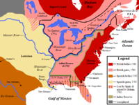
Regions ceded to, ceded by or purchased from Native American Tribes
- Black Hawk PurchaseBlack Hawk PurchaseThe Black Hawk Purchase, sometimes called the Forty-Mile Strip or Scott's Purchase, was a land acquisition made in what is now Iowa by the United States federal government. The land, originally owned by the Sauk, Meskwaki , and Ho-Chunk Native American people, was acquired by treaty following...
; $640,000; purchased 1832; Michigan Territory (eventually Iowa) - Cherokee OutletCherokee OutletThe Cherokee Outlet, often mistakenly referred to as the Cherokee Strip, was located in what is now the state of Oklahoma, in the United States. It was a sixty-mile wide strip of land south of the Oklahoma-Kansas border between the 96th and 100th meridians. It was about 225 miles long and in 1891...
; $7,000,000; purchased 1893; Oklahoma Territory (eventually Oklahoma) - Cherokee StripCherokee Strip (Kansas)The Cherokee Strip of Kansas, in the United States, was a disputed strip of land on the southern border of the state.-Description:In 1825 the Osage Nation was given a reservation in eastern Indian territory in what is now Kansas. In the Treaty of New Echota, May 23, 1836, the northern border of the...
(a disputed 2 mile wide tract of land between the Cherokee NationCherokee Nation (19th century)The Cherokee Nation of the 19th century —an historic entity —was a legal, autonomous, tribal government in North America existing from 1794–1906. Often referred to simply as The Nation by its inhabitants, it should not be confused with what is known today as the "modern" Cherokee Nation...
and KansasKansasKansas is a US state located in the Midwestern United States. It is named after the Kansas River which flows through it, which in turn was named after the Kansa Native American tribe, which inhabited the area. The tribe's name is often said to mean "people of the wind" or "people of the south...
); ceded 1866; to Kansas - The Indian TerritoryIndian TerritoryThe Indian Territory, also known as the Indian Territories and the Indian Country, was land set aside within the United States for the settlement of American Indians...
; ceded by the U.S. to Native AmericansNative Americans in the United StatesNative Americans in the United States are the indigenous peoples in North America within the boundaries of the present-day continental United States, parts of Alaska, and the island state of Hawaii. They are composed of numerous, distinct tribes, states, and ethnic groups, many of which survive as...
; 1834 - Jackson PurchaseJackson Purchase (U.S. historical region)The Jackson Purchase is a region of western Tennessee and southwestern Kentucky, bounded by the Tennessee River on the east, the Ohio River on the north, and the Mississippi River on the west, that was ceded to the United States by the Chickasaw Peoples in 1818...
; $300,000; purchased 1818; from the Chickasaw NationChickasaw NationThe Chickasaw Nation is a federally recognized Native American nation, located in Oklahoma. They are one of the members of the Five Civilized Tribes. The Five Civilized Tribes were differentiated from other Indian reservations in that they had semi-autonomous constitutional governments and...
to Tennessee and Kentucky - Platte PurchasePlatte PurchaseThe Platte Purchase was a land acquisition in 1836 by the United States government from Native American tribes all of which was east bank lands along the Missouri River that added to the northwest corner of the state of Missouri. The area acquired is almost as large as the states of Delaware and...
; $7,500; purchased 1836; Missouri - Saginaw Cession; ceded 1819; to Michigan Territory (eventually Michigan)
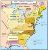
State cessions to / from other states, territories or the federal government

State cessions
The state cessions are those areas of the United States that the separate states ceded to the federal government in the late 18th and early 19th century...
made in the building of the U.S.
- The Delaware Wedge, settled 1921.
- District of Columbia; to the Federal GovernmentFederal government of the United StatesThe federal government of the United States is the national government of the constitutional republic of fifty states that is the United States of America. The federal government comprises three distinct branches of government: a legislative, an executive and a judiciary. These branches and...
from VirginiaVirginiaThe Commonwealth of Virginia , is a U.S. state on the Atlantic Coast of the Southern United States. Virginia is nicknamed the "Old Dominion" and sometimes the "Mother of Presidents" after the eight U.S. presidents born there...
and MarylandMarylandMaryland is a U.S. state located in the Mid Atlantic region of the United States, bordering Virginia, West Virginia, and the District of Columbia to its south and west; Pennsylvania to its north; and Delaware to its east...
, 1790. - District of Columbia RetrocessionRetrocession (District of Columbia)District of Columbia retrocession is the process of returning the land that was given to the federal government for the original purpose of creating the national capital. The District of Columbia was formed in 1791 from of land ceded by the states of Maryland and Virginia in accordance with the...
; the return to Virginia of the District of Columbia lands which Virginia had originally ceded for its creation, 1847. - Greer County, TexasGreer County, TexasGreer County, was a county created by the Texas legislature on February 8, 1860 , was land claimed by both Texas and the United States.-Origin of the dispute:...
; a disputed county claimed both by Texas and the Federal GovernmentFederal government of the United StatesThe federal government of the United States is the national government of the constitutional republic of fifty states that is the United States of America. The federal government comprises three distinct branches of government: a legislative, an executive and a judiciary. These branches and...
; to Oklahoma Territory, 1896. - The Honey Lands; a disputed tract of land between the Territory of Iowa and State of MissouriMissouriMissouri is a US state located in the Midwestern United States, bordered by Iowa, Illinois, Kentucky, Tennessee, Arkansas, Oklahoma, Kansas and Nebraska. With a 2010 population of 5,988,927, Missouri is the 18th most populous state in the nation and the fifth most populous in the Midwest. It...
; to State of IowaIowaIowa is a state located in the Midwestern United States, an area often referred to as the "American Heartland". It derives its name from the Ioway people, one of the many American Indian tribes that occupied the state at the time of European exploration. Iowa was a part of the French colony of New...
, 1851 - District of Kentucky; from Virginia; became the Commonwealth of KentuckyKentuckyThe Commonwealth of Kentucky is a state located in the East Central United States of America. As classified by the United States Census Bureau, Kentucky is a Southern state, more specifically in the East South Central region. Kentucky is one of four U.S. states constituted as a commonwealth...
, 1792. - District of MaineDistrict of MaineThe District of Maine was a legal designation for what is now the U.S. state of Maine from American independence until the Missouri Compromise on March 4, 1820, after which it gained its independence from Massachusetts and became the 23rd state in the Union...
; from MassachusettsMassachusettsThe Commonwealth of Massachusetts is a state in the New England region of the northeastern United States of America. It is bordered by Rhode Island and Connecticut to the south, New York to the west, and Vermont and New Hampshire to the north; at its east lies the Atlantic Ocean. As of the 2010...
; became the State of MaineMaineMaine is a state in the New England region of the northeastern United States, bordered by the Atlantic Ocean to the east and south, New Hampshire to the west, and the Canadian provinces of Quebec to the northwest and New Brunswick to the northeast. Maine is both the northernmost and easternmost...
, 1820. - The Toledo War#Creation of the Toledo Strip; the object of the nearly bloodless Toledo WarToledo WarThe Toledo War , also known as the Michigan-Ohio War, was the almost entirely bloodless boundary dispute between the U.S. state of Ohio and the adjoining territory of Michigan....
between OhioOhioOhio is a Midwestern state in the United States. The 34th largest state by area in the U.S.,it is the 7th‑most populous with over 11.5 million residents, containing several major American cities and seven metropolitan areas with populations of 500,000 or more.The state's capital is Columbus...
and MichiganMichiganMichigan is a U.S. state located in the Great Lakes Region of the United States of America. The name Michigan is the French form of the Ojibwa word mishigamaa, meaning "large water" or "large lake"....
; to Ohio, 1837. - Washington DistrictWashington District, North CarolinaThe Washington District of North Carolina was in a remote area west of the Appalachian Mountains, officially existing for only a short period of time , although it had been self-proclaimed and functioning as an independent governing entity since the spring of 1775...
; from North Carolina; became the Southwest TerritorySouthwest TerritoryThe Territory South of the River Ohio, more commonly known as the Southwest Territory, was an organized incorporated territory of the United States that existed from May 26, 1790, until June 1, 1796, when it was admitted to the United States as the State of Tennessee.The Southwest Territory was...
, 1790. - West VirginiaWest VirginiaWest Virginia is a state in the Appalachian and Southeastern regions of the United States, bordered by Virginia to the southeast, Kentucky to the southwest, Ohio to the northwest, Pennsylvania to the northeast and Maryland to the east...
; from Virginia, CSAVirginiaThe Commonwealth of Virginia , is a U.S. state on the Atlantic Coast of the Southern United States. Virginia is nicknamed the "Old Dominion" and sometimes the "Mother of Presidents" after the eight U.S. presidents born there...
; separating itself from the ConfederacyConfederate States of AmericaThe Confederate States of America was a government set up from 1861 to 1865 by 11 Southern slave states of the United States of America that had declared their secession from the U.S...
, declared 1861; admitted to the Union in 1863. - The Western ReserveConnecticut Western ReserveThe Connecticut Western Reserve was land claimed by Connecticut from 1662 to 1800 in the Northwest Territory in what is now northeastern Ohio.-History:...
; from ConnecticutConnecticutConnecticut is a state in the New England region of the northeastern United States. It is bordered by Rhode Island to the east, Massachusetts to the north, and the state of New York to the west and the south .Connecticut is named for the Connecticut River, the major U.S. river that approximately...
to the Northwest TerritoryNorthwest TerritoryThe Territory Northwest of the River Ohio, more commonly known as the Northwest Territory, was an organized incorporated territory of the United States that existed from July 13, 1787, until March 1, 1803, when the southeastern portion of the territory was admitted to the Union as the state of Ohio...
(Ohio), 1800. - The Yazoo LandsYazoo landsThe Yazoo lands were the sparsely-populated central and western areas of the U.S. state of Georgia, when its western border stretched back to the Mississippi River. It was named for the Yazoo tribe of Native Americans. Several other places and things were named Yazoo, either for or along with the...
; from Georgia to the Mississippi TerritoryMississippi TerritoryThe Territory of Mississippi was an organized incorporated territory of the United States that existed from April 7, 1798, until December 10, 1817, when the final extent of the territory was admitted to the Union as the state of Mississippi....
, 1802.
Former organized territories
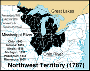
- Northwest TerritoryNorthwest TerritoryThe Territory Northwest of the River Ohio, more commonly known as the Northwest Territory, was an organized incorporated territory of the United States that existed from July 13, 1787, until March 1, 1803, when the southeastern portion of the territory was admitted to the Union as the state of Ohio...
(1789–1803), became the state of OhioOhioOhio is a Midwestern state in the United States. The 34th largest state by area in the U.S.,it is the 7th‑most populous with over 11.5 million residents, containing several major American cities and seven metropolitan areas with populations of 500,000 or more.The state's capital is Columbus...
, and the Territory of Indiana. - Territory South of the River Ohio (also known as the Southwest TerritorySouthwest TerritoryThe Territory South of the River Ohio, more commonly known as the Southwest Territory, was an organized incorporated territory of the United States that existed from May 26, 1790, until June 1, 1796, when it was admitted to the United States as the State of Tennessee.The Southwest Territory was...
) (1790–1796) became the State of TennesseeTennesseeTennessee is a U.S. state located in the Southeastern United States. It has a population of 6,346,105, making it the nation's 17th-largest state by population, and covers , making it the 36th-largest by total land area...
. - Territory of Mississippi (1798–1817) became the State of MississippiMississippiMississippi is a U.S. state located in the Southern United States. Jackson is the state capital and largest city. The name of the state derives from the Mississippi River, which flows along its western boundary, whose name comes from the Ojibwe word misi-ziibi...
and the Territory of Alabama. - Territory of Indiana (1800–1816) split into the Illinois Territory, the Michigan Territory, and the State of IndianaIndianaIndiana is a US state, admitted to the United States as the 19th on December 11, 1816. It is located in the Midwestern United States and Great Lakes Region. With 6,483,802 residents, the state is ranked 15th in population and 16th in population density. Indiana is ranked 38th in land area and is...
. - Territory of Orleans (1804–1812) became the State of LouisianaLouisianaLouisiana is a state located in the southern region of the United States of America. Its capital is Baton Rouge and largest city is New Orleans. Louisiana is the only state in the U.S. with political subdivisions termed parishes, which are local governments equivalent to counties...
. - Territory of Michigan (1805–1837) became State of MichiganMichiganMichigan is a U.S. state located in the Great Lakes Region of the United States of America. The name Michigan is the French form of the Ojibwa word mishigamaa, meaning "large water" or "large lake"....
and the Territory of Wisconsin. - Territory of Louisiana (1805–1812) (preceded by the District of LouisianaDistrict of LouisianaThe District of Louisiana, or Louisiana District, was an official, temporary, United States government designation for the portion of the Louisiana Purchase that had not been organized into the Orleans Territory. It officially existed from March 10, 1804 until July 4, 1805, when it was incorporated...
), then renamed the Territory of Missouri. - Territory of Illinois (1809–1818) split into the State of IllinoisIllinoisIllinois is the fifth-most populous state of the United States of America, and is often noted for being a microcosm of the entire country. With Chicago in the northeast, small industrial cities and great agricultural productivity in central and northern Illinois, and natural resources like coal,...
and additions to the Michigan Territory. - Territory of Missouri (1812–1821) became the State of MissouriMissouriMissouri is a US state located in the Midwestern United States, bordered by Iowa, Illinois, Kentucky, Tennessee, Arkansas, Oklahoma, Kansas and Nebraska. With a 2010 population of 5,988,927, Missouri is the 18th most populous state in the nation and the fifth most populous in the Midwest. It...
and Unorganized Territory (the eastern part of which was attached to the Territory of Michigan in 1834). - Territory of Alabama (1817–1819) became State of AlabamaAlabamaAlabama is a state located in the southeastern region of the United States. It is bordered by Tennessee to the north, Georgia to the east, Florida and the Gulf of Mexico to the south, and Mississippi to the west. Alabama ranks 30th in total land area and ranks second in the size of its inland...
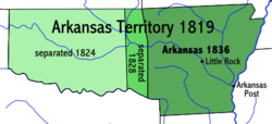
. - Territory of Arkansaw (1819–1836) became the State of ArkansasArkansasArkansas is a state located in the southern region of the United States. Its name is an Algonquian name of the Quapaw Indians. Arkansas shares borders with six states , and its eastern border is largely defined by the Mississippi River...
, additions to the unorganized territory of the original Louisiana Purchase, and the unorganized Indian Territory (which eventually spawned Indian TerritoryIndian TerritoryThe Indian Territory, also known as the Indian Territories and the Indian Country, was land set aside within the United States for the settlement of American Indians...
, Oklahoma TerritoryOklahoma TerritoryThe Territory of Oklahoma was an organized incorporated territory of the United States that existed from May 2, 1890, until November 16, 1907, when it was joined with the Indian Territory under a new constitution and admitted to the Union as the State of Oklahoma.-Organization:Oklahoma Territory's...
and No Man's Land). - Territory of Florida (1822–1845) became the State of FloridaFloridaFlorida is a state in the southeastern United States, located on the nation's Atlantic and Gulf coasts. It is bordered to the west by the Gulf of Mexico, to the north by Alabama and Georgia and to the east by the Atlantic Ocean. With a population of 18,801,310 as measured by the 2010 census, it...
. - Territory of Wisconsin (1836–1848) split into the State of WisconsinWisconsinWisconsin is a U.S. state located in the north-central United States and is part of the Midwest. It is bordered by Minnesota to the west, Iowa to the southwest, Illinois to the south, Lake Michigan to the east, Michigan to the northeast, and Lake Superior to the north. Wisconsin's capital is...
, the Iowa Territory and Unorganized Territory. - Territory of Iowa (1838–1846) split into the State of IowaIowaIowa is a state located in the Midwestern United States, an area often referred to as the "American Heartland". It derives its name from the Ioway people, one of the many American Indian tribes that occupied the state at the time of European exploration. Iowa was a part of the French colony of New...
and unorganized territory of the original Louisiana Purchase. - Territory of Oregon (1848–1859) preceded by the unrecognized Oregon CountryOregon CountryThe Oregon Country was a predominantly American term referring to a disputed ownership region of the Pacific Northwest of North America. The region was occupied by British and French Canadian fur traders from before 1810, and American settlers from the mid-1830s, with its coastal areas north from...
; split into the State of OregonOregonOregon is a state in the Pacific Northwest region of the United States. It is located on the Pacific coast, with Washington to the north, California to the south, Nevada on the southeast and Idaho to the east. The Columbia and Snake rivers delineate much of Oregon's northern and eastern...
and Washington Territory. - Territory of Minnesota (1849–1858) preceded (mostly) by unorganized territory of the original Louisiana Purchase; split into the State of MinnesotaMinnesotaMinnesota is a U.S. state located in the Midwestern United States. The twelfth largest state of the U.S., it is the twenty-first most populous, with 5.3 million residents. Minnesota was carved out of the eastern half of the Minnesota Territory and admitted to the Union as the thirty-second state...
and unorganized territory of the original Louisiana Purchase. - Territory of New Mexico (1850–1912) preceded by Nuevo MexicoSanta Fe de Nuevo MéxicoSanta Fe de Nuevo México was a province of New Spain and later Mexico that existed from the late 16th century up through the mid-19th century. It was centered on the upper valley of the Rio Grande , in an area that included most of the present-day U.S. state of New Mexico...
; (the southern part was known as the Arizona Territory (CSA)Arizona Territory (CSA)The Territory of Arizona was a territory claimed by the Confederate States of America during the American Civil War, between 1861 and 1865. It consisted of the portion of the New Mexico Territory south of the 34th parallel north including parts of the modern states of New Mexico and Arizona. Its...
(1861–1864) by the Confederate States of AmericaConfederate States of AmericaThe Confederate States of America was a government set up from 1861 to 1865 by 11 Southern slave states of the United States of America that had declared their secession from the U.S...
); split into the Arizona Territory (USA)Arizona TerritoryThe Territory of Arizona was an organized incorporated territory of the United States that existed from February 24, 1863 until February 14, 1912, when it was admitted to the Union as the 48th state....
and State of New Mexico (USA)New MexicoNew Mexico is a state located in the southwest and western regions of the United States. New Mexico is also usually considered one of the Mountain States. With a population density of 16 per square mile, New Mexico is the sixth-most sparsely inhabited U.S...
. - Territory of Utah (1850–1896) preceded by Alta CaliforniaAlta CaliforniaAlta California was a province and territory in the Viceroyalty of New Spain and later a territory and department in independent Mexico. The territory was created in 1769 out of the northern part of the former province of Las Californias, and consisted of the modern American states of California,...
and the unrecognized State of DeseretState of DeseretThe State of Deseret was a proposed state of the United States, propositioned in 1849 by Latter-day Saint settlers in Salt Lake City. The provisional state existed for slightly over two years and was never recognized by the United States government...
; split into the State of UtahUtahUtah is a state in the Western United States. It was the 45th state to join the Union, on January 4, 1896. Approximately 80% of Utah's 2,763,885 people live along the Wasatch Front, centering on Salt Lake City. This leaves vast expanses of the state nearly uninhabited, making the population the...
, the Nevada Territory, additions to the Colorado Territory and additions to the Wyoming Territory. - Territory of Washington (1853–1889) became the State of Washington and additions to the Idaho Territory.
- Territory of Kansas (1854–1861) preceded by unorganized territory of the original Louisiana Purchase; split into the State of KansasKansasKansas is a US state located in the Midwestern United States. It is named after the Kansas River which flows through it, which in turn was named after the Kansa Native American tribe, which inhabited the area. The tribe's name is often said to mean "people of the wind" or "people of the south...
and additions to the Colorado Territory. - Territory of Nebraska (1854–1867) preceded by unorganized territory of the original Louisiana Purchase; split into the State of NebraskaNebraskaNebraska is a state on the Great Plains of the Midwestern United States. The state's capital is Lincoln and its largest city is Omaha, on the Missouri River....
, the Dakota Territory, additions to the Idaho Territory and additions to the Colorado Territory. - Territory of Colorado (1861–1876) preceded by parts of the territories of: Kansas, Utah, New Mexico and Nebraska; became the State of ColoradoColoradoColorado is a U.S. state that encompasses much of the Rocky Mountains as well as the northeastern portion of the Colorado Plateau and the western edge of the Great Plains...
. (See also Jefferson TerritoryJefferson TerritoryThe Provisional Government of the Territory of Jefferson was an extralegal and unrecognized United States territory that existed from October 24, 1859 until the creation of the Colorado Territory on February 28, 1861...
.) - Territory of Nevada (1861–1864) preceded by the Utah Territory and the unrecognized State of DeseretState of DeseretThe State of Deseret was a proposed state of the United States, propositioned in 1849 by Latter-day Saint settlers in Salt Lake City. The provisional state existed for slightly over two years and was never recognized by the United States government...
; became the State of NevadaNevadaNevada is a state in the western, mountain west, and southwestern regions of the United States. With an area of and a population of about 2.7 million, it is the 7th-largest and 35th-most populous state. Over two-thirds of Nevada's people live in the Las Vegas metropolitan area, which contains its...
. - Territory of Dakota (1861–1889) became the State of North DakotaNorth DakotaNorth Dakota is a state located in the Midwestern region of the United States of America, along the Canadian border. The state is bordered by Canada to the north, Minnesota to the east, South Dakota to the south and Montana to the west. North Dakota is the 19th-largest state by area in the U.S....
, the State of South DakotaSouth DakotaSouth Dakota is a state located in the Midwestern region of the United States. It is named after the Lakota and Dakota Sioux American Indian tribes. Once a part of Dakota Territory, South Dakota became a state on November 2, 1889. The state has an area of and an estimated population of just over...
, additions to the Idaho Territory and additions to the Wyoming Territory. - Territory of Arizona (1863–1912) became the State of ArizonaArizonaArizona ; is a state located in the southwestern region of the United States. It is also part of the western United States and the mountain west. The capital and largest city is Phoenix...
and an addition to the State of NevadaNevadaNevada is a state in the western, mountain west, and southwestern regions of the United States. With an area of and a population of about 2.7 million, it is the 7th-largest and 35th-most populous state. Over two-thirds of Nevada's people live in the Las Vegas metropolitan area, which contains its...
. - Territory of Idaho (1863–1890) preceded by parts of the territories of: Washington, Dakota, and Nebraska; became the State of IdahoIdahoIdaho is a state in the Rocky Mountain area of the United States. The state's largest city and capital is Boise. Residents are called "Idahoans". Idaho was admitted to the Union on July 3, 1890, as the 43rd state....
, the Montana Territory, additions to the Dakota Territory and additions to the Wyoming Territory. - Territory of Montana (1864–1889) became the State of MontanaMontanaMontana is a state in the Western United States. The western third of Montana contains numerous mountain ranges. Smaller, "island ranges" are found in the central third of the state, for a total of 77 named ranges of the Rocky Mountains. This geographical fact is reflected in the state's name,...
. - Territory of Wyoming (1868–1890) preceded by parts of the territories of: Dakota, Utah and Idaho; became the State of WyomingWyomingWyoming is a state in the mountain region of the Western United States. The western two thirds of the state is covered mostly with the mountain ranges and rangelands in the foothills of the Eastern Rocky Mountains, while the eastern third of the state is high elevation prairie known as the High...
. - Territory of Oklahoma (1890–1907) (preceded by the unorganized Indian TerritoryIndian TerritoryThe Indian Territory, also known as the Indian Territories and the Indian Country, was land set aside within the United States for the settlement of American Indians...
(1834–1907) and the Neutral Strip; became the State of OklahomaOklahomaOklahoma is a state located in the South Central region of the United States of America. With an estimated 3,751,351 residents as of the 2010 census and a land area of 68,667 square miles , Oklahoma is the 28th most populous and 20th-largest state...
. - Territory of HawaiiTerritory of HawaiiThe Territory of Hawaii or Hawaii Territory was an organized incorporated territory of the United States that existed from July 7, 1898, until August 21, 1959, when its territory, with the exception of Johnston Atoll, was admitted to the Union as the fiftieth U.S. state, the State of Hawaii.The U.S...
(1898–1959) preceded by the Republic of HawaiiRepublic of HawaiiThe Republic of Hawaii was the formal name of the government that controlled Hawaii from 1894 to 1898 when it was run as a republic. The republic period occurred between the administration of the Provisional Government of Hawaii which ended on July 4, 1894 and the adoption of the Newlands...
; became the State of HawaiiHawaiiHawaii is the newest of the 50 U.S. states , and is the only U.S. state made up entirely of islands. It is the northernmost island group in Polynesia, occupying most of an archipelago in the central Pacific Ocean, southwest of the continental United States, southeast of Japan, and northeast of...
. - Territory of Alaska (1912–1959) (preceded by the Department of AlaskaDepartment of AlaskaThe Department of Alaska was the designation for the government of Alaska from its purchase by the United States of America in 1867 until its organization as the District of Alaska in 1884. During the department era, Alaska was variously under the jurisdiction of the U.S. Army , the United States...
and the District of AlaskaDistrict of AlaskaThe District of Alaska was the governmental designation for Alaska from May 17, 1884 to August 24, 1912, when it became Alaska Territory. Previously it had been known as the Department of Alaska. At the time, legislators in Washington, D.C., were occupied with post-Civil War reconstruction issues,...
); became the State of AlaskaAlaskaAlaska is the largest state in the United States by area. It is situated in the northwest extremity of the North American continent, with Canada to the east, the Arctic Ocean to the north, and the Pacific Ocean to the west and south, with Russia further west across the Bering Strait...
.
Internal United States land grants, cessions, districts, departments, claims and settlements

Native Americans in the United States
Native Americans in the United States are the indigenous peoples in North America within the boundaries of the present-day continental United States, parts of Alaska, and the island state of Hawaii. They are composed of numerous, distinct tribes, states, and ethnic groups, many of which survive as...
cessions or land purchases.
- District of AlaskaDistrict of AlaskaThe District of Alaska was the governmental designation for Alaska from May 17, 1884 to August 24, 1912, when it became Alaska Territory. Previously it had been known as the Department of Alaska. At the time, legislators in Washington, D.C., were occupied with post-Civil War reconstruction issues,...
; renamed the Alaska TerritoryAlaska TerritoryThe Territory of Alaska was an organized incorporated territory of the United States that existed from August 24, 1912, until January 3, 1959, when it was admitted to the Union as the State of Alaska...
in 1912.
- Cumberland District, North Carolina (also called the District of Miro); Tennessee.
- District of LouisianaDistrict of LouisianaThe District of Louisiana, or Louisiana District, was an official, temporary, United States government designation for the portion of the Louisiana Purchase that had not been organized into the Orleans Territory. It officially existed from March 10, 1804 until July 4, 1805, when it was incorporated...
; Missouri, Kansas, Iowa, Nebraska, Minnesota, North and South Dakota, Montana, Arkansas, Oklahoma, Colorado, Wyoming; renamed Missouri TerritoryMissouri TerritoryThe Territory of Missouri was an organized incorporated territory of the United States that existed from June 4, 1812 until August 10, 1821, when the southeastern portion of the territory was admitted to the Union as the State of Missouri.-History:...
in 1812.
- Military Tract of 1812Military Tract of 1812In May 1812, an act of Congress was passed which set aside bounty lands as payment to volunteer soldiers for the War against the British...
; Illinois, Michigan, Arkansas, Missouri.
- Ohio CountryOhio CountryThe Ohio Country was the name used in the 18th century for the regions of North America west of the Appalachian Mountains and in the region of the upper Ohio River south of Lake Erie...
; parts of Ohio, Indiana, Pennsylvania, West Virginia. - Pike's Peak CountryPike's Peak CountryPike's Peak Country was the name given to the gold mining region of the western United States near Pikes Peak during the Pike's Peak Gold Rush of 1858-1861...
; Colorado.
New York
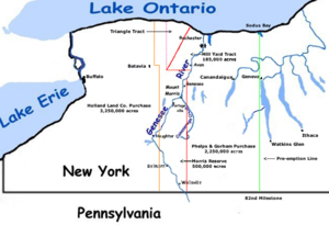
- Central New York Military TractCentral New York Military TractThe Military Tract of Central New York, also called the New Military Tract, consisted of nearly two million acres of bounty land set aside to compensate New York’s soldiers after their participation in the Revolutionary War....
(New York) - The Holland Purchase (New York)
- Macomb's PurchaseMacomb's PurchaseMacomb's Purchase is a large historical area of northern New York, USA purchased from the state in 1791 by Alexander Macomb, who had become rich as a merchant in the American Revolution.-History and geography:...
(New York) - The Mill Yard TractThe Mill Yard TractThe Mill Yard Tract was a portion of the Phelps and Gorham Purchase of western New York State. It consisted of a tract deep and , abutting the west bank of the Genesee River stretching from the approximate locations of the present day town of Avon north to the community of Charlotte at Lake...
(New York) - The Morris Reserve (New York)
- Phelps and Gorham PurchasePhelps and Gorham PurchaseThe Phelps and Gorham Purchase was the purchase in 1788 of the pre-emptive right to some 6,000,000 acres of land in western New York State for $1,000,000 . This was all land in western New York west of Seneca Lake between Lake Ontario and the Pennsylvania border...
(New York) - The Triangle TractThe Triangle TractThe Triangle Tract was 87,000 acre parcel of land abutting the Mill Yard Tract portion of the Phelps and Gorham Purchase in western New York State in the USA...
(New York)
Ohio
- Canal LandsCanal LandsCanal Lands were tracts of land donated by the federal government to several Great Lakes states in the 19th century to encourage internal improvements and aid in funding the construction of Canals...
- College LandsCollege LandsThe College Lands were a tract of land in the Northwest Territory, later Ohio, that the Congress donated for the support of a university. Ohio University became the first college northwest of the Ohio River as a beneficiary of this tract.-Background:...
- College TownshipCollege TownshipThe "College Township" was the full survey township located in the northwest corner of Butler County, Ohio, now corresponding to the civil township of Oxford, designated by the Ohio General Assembly to be the site of the state university now called Miami University...
- Congress LandsCongress LandsThe Congress Lands was a group of land tracts in Ohio that made land available for sale to members of the general public through land offices in various cities, and through the General Land Office...
(or Congressional Lands, 1798–1821)- Congress Lands North of Old Seven RangesCongress Lands North of Old Seven RangesThe Congress Lands North of the Old Seven Ranges was a land tract in northeast Ohio that was established by the Congress early in the 19th century...
- Congress Lands West of Miami RiverCongress Lands West of Miami RiverThe Congress Lands West of Miami River was a land tract in southwest Ohio that was established by the Congress late in the 18th century. It is located south of the Greenville Treaty Line, east of Indiana, and north of the Great Miami River...
- Congress Lands East of Scioto RiverCongress Lands East of Scioto RiverThe Congress Lands East of Scioto River was a land tract in southern Ohio that was established by the Congress late in the 18th century. It is located south of the United States Military District and Refugee Tract, west of the Old Seven Ranges, east of the Virginia Military District and north of...
- North and East of the First Principal Meridian
- South and East of the First Principal MeridianSouth and East of the First Principal MeridianSouth and East of the First Principal Meridian is a land description in the American Midwest.In 1812, Congress authorized the Surveyor General to survey the northern and western border of Ohio “as soon as the consent of the Indians can be obtained.“ In 1817, the northern portion of the Ohio-Indiana...
- Congress Lands North of Old Seven Ranges
- Dohrman TractDohrman TractDohrman Tract or Dohrman’s Grant was a land tract in eastern Ohio granted by Congress to Arnold Henry Dohrman , who helped the American cause in the Revolutionary War....
- Ephraim Kimberly GrantEphraim Kimberly GrantThe Ephraim Kimberly Grant was a land tract in eastern Ohio that was granted to an American Revolutionary War veteran by Congress late in the 18th century. It was located in the Seven Ranges along the Ohio River.-Background:...
- FirelandsFirelandsThe Firelands or Sufferers' Lands tract was located at the western end of the Connecticut Western Reserve in what is now the U.S. state of Ohio...
or Sufferers' Lands - Fort WashingtonFort Washington, Cincinnati, OhioFort Washington was a fort in the early history of Cincinnati, Ohio. The location is marked by a plaque at the Guilford School building, at 421 E 4th St, Cincinnati, which now occupies the site...
- French GrantFrench Grantthumb|The proposed purchase by the Scioto Company is shown in red. The proposed purchase by the [[Ohio Company of Associates|Ohio Company]] is in blue. The final purchase by the Ohio Company is in green...
- Indian Land GrantsIndian Land GrantsIndian Land Grants were land tracts granted to various Indians by Treaty or by United States Congressional action in the Nineteenth century in northwestern Ohio.-Grants near St. Mary's River:-Jean Baptiste Richardville:...
- Maumee Road LandsMaumee Road LandsMaumee Road Lands were a group of land tracts granted by the United States Congress to the state of Ohio in 1823 along the path of a proposed road in the northwest corner of the state.-History:...
- Michigan Survey (or Michigan Meridian Survey; also Toledo Tract)
- Miami & Erie Canal Lands
- Ministerial LandsMinisterial LandsThe Ministerial Lands were tracts of land in the Northwest Territory, later Ohio, that the Congress donated for the support of clergy.In the contracts that the Congress wrote for purchases of large tracts of land in the Northwest Territory in the 1780s by the Ohio Company of Associates and John...
- The Moravian Indian Grants
- Gnadenhutten Tract
- Salem Tract
- Schoenbrunn Tract
- Ohio & Erie Canal Lands
- The Ohio CompanyOhio Company of AssociatesThe Ohio Company of Associates, also known as the Ohio Company, was a land company which is today credited with becoming the first non-American Indian group to settle in the present-day state of Ohio...
- Donation TractDonation TractThe Donation Tract was a land tract in southern Ohio that was established by the Congress late in the 18th century to buffer Ohio Company lands against Indians. Congress gave lots to men who settled on the land...
- First Purchase
- Marietta
- Purchase on the MuskingumPurchase on the MuskingumThe Purchase on the Muskingum also called Ohio Company’s Second Purchase, was a tract of land in the Northwest Territory, later Ohio, that the Ohio Company of Associates purchased from the United States federal government in 1792.-History:...
(or Second Purchase)
- Donation Tract
- Refugee TractRefugee TractThe Refugee Tract is an area of land in Ohio, United States granted to people from British Canada who left home prior to July 4, 1776, stayed in the US until November 25, 1783 continuously, and aided the revolutionary cause.-Location:...
- Salt ReservationsSalt ReservationsThe Salt Reservations were a collection of land tracts surrounding salt springs in Ohio and some other states that were donated to the states by the federal government early in the 19th century....
(or Salt Lands) - School LandsSchool LandsThe School Lands are part of the Ohio Lands, comprising land grants in Ohio from the United States federal government for public schools. Support for public education in the United States predates the constitution; two years before the adoption of the United States Constitution of 1787, the...
- Seven RangesSeven RangesThe Seven Ranges was a land tract in eastern Ohio that was the first tract to be surveyed in what became the Public Land Survey System. The tract is across the northern edge, on the western edge, with the south and east sides along the Ohio River...
(or Old Seven Ranges) - Symmes PurchaseSymmes PurchaseThe Symmes Purchase, also known as the Miami Purchase, was an area of land in Southwestern Ohio in what is now Hamilton, Butler, and Warren Counties. It was purchased by Judge John Cleves Symmes of New Jersey from the Continental Congress...
(or Miami Purchase; also the Land Between the Miamis) - Turnpike LandsTurnpike LandsTurnpike Lands were a group of land tracts granted by the United States Congress to the state of Ohio in 1827 along the path of a proposed road in the northwest corner of the state.-History:...
- Twelve-Mile Square Reservation
- Two-Mile Square Reservation
- United States Military DistrictUnited States Military DistrictThe United States Military District was a land tract in central Ohio that was established by the Congress to compensate veterans of the American Revolutionary War for their service...
- Virginia Military DistrictVirginia Military DistrictThe Virginia Military District was an approximately 4.2 million acre area of land in what is now the state of Ohio that was reserved by Virginia to use as payment for veterans of the American Revolutionary War....
- Zane's TractsZane's TractsZane's Tracts were three parcels of land in the Northwest Territory of the United States, later Ohio, that the federal government granted to Ebenezer Zane late in the 18th century, as compensation for establishing a road with ferry service over several rivers....
(or Zane's Grant; also Ebenezer Zane Tract)
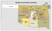
Oklahoma
- Big PastureBig PastureThe Big Pasture was of prairie land, in what is now southwestern Oklahoma. The land had been reserved for grazing use by the Kiowa, Comanche, and Apache tribes after their reserve was opened for settlement by a lottery conducted during June through August 1901...
- Indian TerritoryIndian TerritoryThe Indian Territory, also known as the Indian Territories and the Indian Country, was land set aside within the United States for the settlement of American Indians...
or The Oklahoma Indian CountryIndian CountryIndian country is a term used to describe the many self-governing Native American communities throughout the United States. This usage is reflected in many places, both legal and colloquial... - Neutral Strip (or No Man's Land)
- Unassigned LandsUnassigned LandsUnassigned Lands, or Oklahoma, were in the center of the lands ceded to the United States by the Creek and Seminole Indians following the Civil War and on which no other tribes had been settled...
Indian Reserves
- Cherokee NationCherokee NationThe Cherokee Nation is the largest of three Cherokee federally recognized tribes in the United States. It was established in the 20th century, and includes people descended from members of the old Cherokee Nation who relocated voluntarily from the Southeast to Indian Territory and Cherokees who...
- CheyenneCheyenneCheyenne are a Native American people of the Great Plains, who are of the Algonquian language family. The Cheyenne Nation is composed of two united tribes, the Só'taeo'o and the Tsétsêhéstâhese .The Cheyenne are thought to have branched off other tribes of Algonquian stock inhabiting lands...
-ArapahoArapahoThe Arapaho are a tribe of Native Americans historically living on the eastern plains of Colorado and Wyoming. They were close allies of the Cheyenne tribe and loosely aligned with the Sioux. Arapaho is an Algonquian language closely related to Gros Ventre, whose people are seen as an early...
Reserve - Commanche, KiowaKiowaThe Kiowa are a nation of American Indians and indigenous people of the Great Plains. They migrated from the northern plains to the southern plains in the late 17th century. In 1867, the Kiowa moved to a reservation in southwestern Oklahoma...
and ApachePlains ApacheThe Plains Apache are a Southern Athabaskan group that traditionally live on the Southern Plains of North America and today are centered in Southwestern Oklahoma...
Reserve - IowaIowa tribeThe Iowa , also known as the Báxoje, are a Native American Siouan people. Today they are enrolled in either of two federally recognized tribes, the Iowa Tribe of Oklahoma and the Ioway Tribe of Kansas and Nebraska....
Reserve - KawKaw (tribe)The Kaw Nation are an American Indian people of the central Midwestern United States. The tribe known as Kaw have also been known as the "People of the South wind", "People of water", Kansa, Kaza, Kosa, and Kasa. Their tribal language is Kansa, classified as a Siouan language.The toponym "Kansas"...
Reserve - Kickapoo Reserve
- OsageOsage NationThe Osage Nation is a Native American Siouan-language tribe in the United States that originated in the Ohio River valley in present-day Kentucky. After years of war with invading Iroquois, the Osage migrated west of the Mississippi River to their historic lands in present-day Arkansas, Missouri,...
Reserve
- PoncaPoncaThe Ponca are a Native American people of the Dhegihan branch of the Siouan-language group. There are two federally recognized Ponca tribes: the Ponca Tribe of Nebraska and the Ponca Tribe of Indians of Oklahoma...
and OtoeOtoe tribeThe Otoe or Oto are a Native American people. The Otoe language, Chiwere, is part of the Siouan family and closely related to that of the related Iowa and Missouri tribes.-History:...
–MisouriaMissouri tribeThe Missouria or Missouri are a Native American tribe that originated in the Great Lakes region of United States before European contact. The tribe belongs to the Chiwere division of the Siouan language family, together with the Iowa and Otoe...
Reserve - Citizen PotawatomiPotawatomiThe Potawatomi are a Native American people of the upper Mississippi River region. They traditionally speak the Potawatomi language, a member of the Algonquian family. In the Potawatomi language, they generally call themselves Bodéwadmi, a name that means "keepers of the fire" and that was applied...
and Absentee ShawneeShawneeThe Shawnee, Shaawanwaki, Shaawanooki and Shaawanowi lenaweeki, are an Algonquian-speaking people native to North America. Historically they inhabited the areas of Ohio, Virginia, West Virginia, Western Maryland, Kentucky, Indiana, and Pennsylvania...
Reserve - Sac and Fox ReserveSac and Fox NationThe Sac and Fox Nation is the largest of three federally recognized tribes of Sac and Meskwaki Native Americans. They are located in Oklahoma and are predominantly Sac....
- Tonkawa ReserveTonkawaThe Tickanwa•tic Tribe , better known as the Tonkawa , are a Native American people indigenous to present-day Oklahoma and Texas. They once spoke the now-extinct Tonkawa language believed to have been a language isolate not related to any other indigenous tongues...
- WichitaWichita (tribe)The Wichita people are indigenous inhabitants of North America, who traditionally spoke the Wichita language, a Caddoan language. They have lived in Kansas, Oklahoma, and Texas...
and CaddoCaddoThe Caddo Nation is a confederacy of several Southeastern Native American tribes, who traditionally inhabited much of what is now East Texas, northern Louisiana and portions of southern Arkansas and Oklahoma. Today the Caddo Nation of Oklahoma is a cohesive tribe with its capital at Binger, Oklahoma...
Reserve
Pennsylvania
- Erie TriangleErie TriangleThe Erie Triangle is a tract of American land that was the subject of several competing colonial-era claims and which was eventually acquired by the U.S. federal government and sold to Pennsylvania so that the state would have access to a freshwater port on Lake Erie...
- New PurchaseTreaty of Fort StanwixThe Treaty of Fort Stanwix was an important treaty between North American Indians and the British Empire. It was signed in 1768 at Fort Stanwix, located in present-day Rome, New York...
- Walking PurchaseWalking PurchaseThe Walking Purchase was a purported 1737 agreement between the Penn family, the proprietors of Pennsylvania, and the Lenape . By it the Penn family and proprietors claimed an area of 1,200,000 acres and forced the Lenape to vacate it...
- Welsh TractWelsh TractThe Welsh Tract, also called the Welsh Barony, was a portion of the U.S. state of Pennsylvania settled largely by Welsh-speaking Quakers. It covers 40,000 acres to the west of Philadelphia...
U.S. mainland military administration districts and departments
These entities were sometimes the only governmental authority in the listed areas, although they often co-existed with civil governments in scarcely populated states and territories. Civilian administered "military" tracts, districts, departments, etc., will be listed elsewhere.Central United States
- Department of the MissouriDepartment of the MissouriDepartment of the Missouri was a division of the United States Army that functioned through the American Civil War and the Indian Wars afterwards.-Civil War:...
(1861–1865) Missouri, Arkansas, Illinois, part of Kentucky, and later Kansas; re-configured in 1865 as part of the Division of the Missouri. - Division of the MissouriDepartment of the MissouriDepartment of the Missouri was a division of the United States Army that functioned through the American Civil War and the Indian Wars afterwards.-Civil War:...
(1865–1891).- Department of DakotaDepartment of DakotaA subdivision of the Division of the Missouri, the Department of Dakota was established by the United States Army on August 11, 1866 to encompass all military activities and forts within Minnesota, Dakota Territory and Montana Territory. The Department of Dakota was initially headquartered at Fort...
(1866–1911) Minnesota, Montana, North Dakota, and parts of Idaho, South Dakota and the Yellowstone portion of Wyoming. - Department of the MissouriDepartment of the MissouriDepartment of the Missouri was a division of the United States Army that functioned through the American Civil War and the Indian Wars afterwards.-Civil War:...
(1865–1891) Arkansas, Kansas, Missouri, Indian Territory,and Territory of Oklahoma. - Department of the PlatteDepartment of the PlatteThe Department of the Platte was a military administrative district established by the U.S. Army on March 5, 1866, with boundaries encompassing Iowa, Nebraska, Dakota Territory, Utah Territory and a small portion of Idaho...
(1866–1898) Iowa, Nebraska, Colorado, Dakota Territory, Utah Territory, Wyoming (except Yellowstone), and a portion of Idaho. - Department of Texas (originally part of the Department of the Gulf) Texas after 1865.
- Department of Dakota
- Department of New MexicoDepartment of New MexicoThe Department of New Mexico was a department of the United States Army during the mid-19th century. At first a part of the Department of the West, it was created as an independent department following the breakup of that Division into various departments during the Civil War...
(1861–1898) New Mexico Territory; previously part of the District of California and the Department of the West.
Pacific area
- Pacific Division (1848–1853) lands won in the Mexican–American WarMexican–American WarThe Mexican–American War, also known as the First American Intervention, the Mexican War, or the U.S.–Mexican War, was an armed conflict between the United States and Mexico from 1846 to 1848 in the wake of the 1845 U.S...
; became the original Department of the Pacific in 1853.- Military Department 10 (1848–1851) California.
- Military Department 11 (1848–1851) Oregon Territory.
- Department of the PacificDepartment of the PacificThe Department of the Pacific was a major command of the United States Army during the 19th century.-Formation:The Department of the Pacific was first organized on October 31, 1853, at San Francisco, California, taking over from the previous Pacific Division. The department reported directly to...
(1853–1858; and 1861–1865); separated into the Department of California and the Department of Oregon in 1858.- District of CaliforniaDistrict of CaliforniaThe District of California was a Union Army command department formed during the American Civil War. The district was part of the Department of the Pacific, the commander of the department also being District commander...
(1864–1865) California, Nevada Territory, Arizona Territory, and New Mexico Territory; Utah added 1858 - District of Oregon (1853–1858; and 1864–1867) Washington Territory, Oregon Territory and Idaho Territory.
- District of California
- Department of CaliforniaDepartment of CaliforniaThe Department of California was one of two Army Departments created September 13, 1858, replacing the original Department of the Pacific and was composed of the territory of the United States lying west of the Rocky Mountains and south of Oregon and Washington territories, except the Rogue River...
(1858–1861) the southern part of the Department of the Pacific: California, Nevada, and southern part of Oregon Territory; merged into the Department of the Pacific as the District of California. - Department of OregonDepartment of OregonThe Department of Oregon was one of two Army Departments created September 13, 1858, replacing the original Department of the Pacific and was composed of the Territories of Washington and Oregon, except the Rogue River and Umpqua Districts, which were assigned to the Department of California. Its...
(1858–1861) the northern part of the Department of the Pacific: Washington Territory and Oregon Territory.
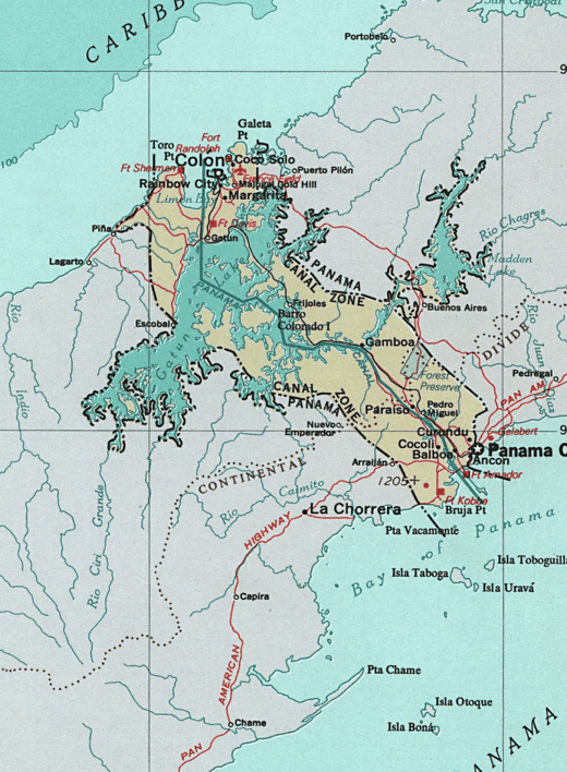
- Military Division of the PacificMilitary Division of the PacificThe Military Division of the Pacific was a major command of the United States Army during the 19th century.-Formation:On July 27, 1865 the Military Division of the Pacific was created under Major General Henry W...
(1865–1891).- Department of AlaskaDepartment of AlaskaThe Department of Alaska was the designation for the government of Alaska from its purchase by the United States of America in 1867 until its organization as the District of Alaska in 1884. During the department era, Alaska was variously under the jurisdiction of the U.S. Army , the United States...
(1868–1884) became the civilian-ruled District of Alaska. - Department of Arizona (1865–1891) Arizona Territory; included New Mexico Territory after 1885.
- Department of the ColumbiaDepartment of the ColumbiaThe Department of the Columbia was a major command of the United States Army during the 19th century.-Formation:On July 27, 1865 the Military Division of the Pacific was created under Major General Henry W...
(1865–1891) Oregon, Washington Territory, part of Idaho Territory, and Alaska after 1870. - New Department of California (1865–1891) California, Nevada Territory, Arizona Territory, and part of New Mexico Territory.
- Department of Alaska
The south
- Department of the Gulf (1862–1865; created by the U.S. for the Civil WarAmerican Civil WarThe American Civil War was a civil war fought in the United States of America. In response to the election of Abraham Lincoln as President of the United States, 11 southern slave states declared their secession from the United States and formed the Confederate States of America ; the other 25...
) Mississippi, Alabama, Louisiana, and Texas. - Trans-MississippiTrans-MississippiThe Trans-Mississippi was the geographic area west of the Mississippi River during the 19th century, containing the states of Arkansas, Louisiana, Missouri and Texas, and the Indian Territory . The term was especially used by the Confederate States of America as the designation for the theater of...
(or Trans-Mississippi Department; CSAConfederate States of AmericaThe Confederate States of America was a government set up from 1861 to 1865 by 11 Southern slave states of the United States of America that had declared their secession from the U.S...
) (1862–1865) Formerly "Military Dept. 2"; Missouri, Arkansas, Texas, Indian Territory (now Oklahoma), Kansas, and Louisiana west of the Mississippi River.
The west
- Department of the WestDepartment of the WestThe Department of the West, later known as the Western Department, was a major command of the United States Army during the 19th century. It oversaw the military affairs in the country west of the Mississippi River to the borders of California and Oregon.-Organization:The Department was first...
(1853–1861) all U.S. lands between the Mississippi RiverMississippi RiverThe Mississippi River is the largest river system in North America. Flowing entirely in the United States, this river rises in western Minnesota and meanders slowly southwards for to the Mississippi River Delta at the Gulf of Mexico. With its many tributaries, the Mississippi's watershed drains...
and the Military District of the Pacific not included in other Districts or Departments.
Possessions and overseas territories subsequently retroceded
- Chamizal, Texas, to MexicoMexicoThe United Mexican States , commonly known as Mexico , is a federal constitutional republic in North America. It is bordered on the north by the United States; on the south and west by the Pacific Ocean; on the southeast by Guatemala, Belize, and the Caribbean Sea; and on the east by the Gulf of...
. - The Milk RiverMilk River (Montana-Alberta)The Milk River is a tributary of the Missouri River, long, in the United States state of Montana and the Canadian province of Alberta. Rising in the Rocky Mountains, the river drains a sparsely populated, semi-arid watershed of , ending just east of Fort Peck, Montana.-Geography:It is formed in...
and Poplar River cessations ceded to the United KingdomUnited Kingdom of Great Britain and IrelandThe United Kingdom of Great Britain and Ireland was the formal name of the United Kingdom during the period when what is now the Republic of Ireland formed a part of it....
, in the Treaty of 1818Treaty of 1818The Convention respecting fisheries, boundary and the restoration of slaves between the United States of America and the United Kingdom of Great Britain and Ireland, also known as the London Convention, Anglo-American Convention of 1818, Convention of 1818, or simply the Treaty of 1818, was a...
. - Panama Canal ZonePanama Canal ZoneThe Panama Canal Zone was a unorganized U.S. territory located within the Republic of Panama, consisting of the Panama Canal and an area generally extending 5 miles on each side of the centerline, but excluding Panama City and Colón, which otherwise would have been partly within the limits of...
, to PanamaPanamaPanama , officially the Republic of Panama , is the southernmost country of Central America. Situated on the isthmus connecting North and South America, it is bordered by Costa Rica to the northwest, Colombia to the southeast, the Caribbean Sea to the north and the Pacific Ocean to the south. The...
. - Commonwealth of the PhilippinesCommonwealth of the PhilippinesThe Commonwealth of the Philippines was a designation of the Philippines from 1935 to 1946 when the country was a commonwealth of the United States. The Commonwealth was created by the Tydings-McDuffie Act, which was passed by the U.S. Congress in 1934. When Manuel L...
to Republic of the PhilippinesPhilippinesThe Philippines , officially known as the Republic of the Philippines , is a country in Southeast Asia in the western Pacific Ocean. To its north across the Luzon Strait lies Taiwan. West across the South China Sea sits Vietnam...
. - Rio Rico, TexasRio Rico, TexasRio Rico is a city near the Rio Grande in the Mexican state of Tamaulipas; it and the surrounding land were part of the US state of Texas that was ceded by the United States to Mexico in 1970...
(Horcón Tract) to Mexico.
Overseas regions primarily under U.S. military administration
- CubaCubaThe Republic of Cuba is an island nation in the Caribbean. The nation of Cuba consists of the main island of Cuba, the Isla de la Juventud, and several archipelagos. Havana is the largest city in Cuba and the country's capital. Santiago de Cuba is the second largest city...
(1898–1902) - American WWII European Occupation ZonesAllied Military Government for Occupied TerritoriesThe Allied Military Government for Occupied Territories was the form of military rule administered by Allied forces during and after World War II within European territories they occupied.-Notable AMGOT:...
- American Occupation Zone of Austria (1945–1955)
- American Occupation Zone of Germany (1945–1955)
- American Occupation Zone of West BerlinWest BerlinWest Berlin was a political exclave that existed between 1949 and 1990. It comprised the western regions of Berlin, which were bordered by East Berlin and parts of East Germany. West Berlin consisted of the American, British, and French occupation sectors, which had been established in 1945...
(1945–1990)
- American Occupation Zone of West Berlin
- Free Territory of Trieste, Zone AFree Territory of TriesteThe Free Territory of Trieste was to be a city-state situated in Central Europe between northern Italy and Yugoslavia, created by the United Nations Security Council in the aftermath of World War II and provisionally administered by an appointed military governor commanding the peacekeeping United...
(1947–1954, administered jointly with the U.K.)
- South KoreaUnited States Army Military Government in KoreaThe United States Army Military Government in Korea, also known as USAMGIK, was the official ruling body of the southern half of the Korean Peninsula from September 8, 1945 to August 15, 1948...
(1945–1948) - Pacific Trust TerritoriesTrust Territory of the Pacific IslandsThe Trust Territory of the Pacific Islands was a United Nations trust territory in Micronesia administered by the United States from 1947 to 1986.-History:...
; included the Republic of PalauPalauPalau , officially the Republic of Palau , is an island nation in the Pacific Ocean, east of the Philippines and south of Tokyo. In 1978, after three decades as being part of the United Nations trusteeship, Palau chose independence instead of becoming part of the Federated States of Micronesia, a...
and the Marshall IslandsMarshall IslandsThe Republic of the Marshall Islands , , is a Micronesian nation of atolls and islands in the middle of the Pacific Ocean, just west of the International Date Line and just north of the Equator. As of July 2011 the population was 67,182...
(Micronesia under U.S. administration, 1947–1986) - Ryukyu Islands, Japan (Okinawa, 1945–1972)
Proclaimed but non-extant entities
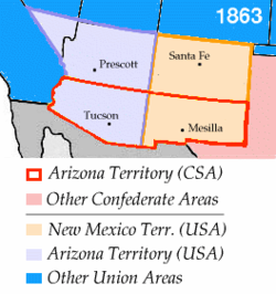
- Absaroka
- Arizona Territory (CSA)Arizona Territory (CSA)The Territory of Arizona was a territory claimed by the Confederate States of America during the American Civil War, between 1861 and 1865. It consisted of the portion of the New Mexico Territory south of the 34th parallel north including parts of the modern states of New Mexico and Arizona. Its...
(parts of the territories of Arizona and New Mexico) - Kingdom of Beaver Island
- Republic of California (also known as the "Bear Flag Republic") (June 14, 1846–July 9, 1846); then becoming the unorganized "Territory of California".
- CascadiaCascadia (independence movement)Cascadia is the proposed name for a bioregional political entity and/or an independent nation located within the Cascadian bioregion of the Pacific Northwest of North America...
- Cimarron Territory
- Conch RepublicConch RepublicThe Conch Republic is a micronation declared as a tongue-in-cheek secession of the city of Key West from the United States on April 23, 1982. It has been maintained as a tourism booster for the city since...
- Confederate States of America - CSAConfederate States of AmericaThe Confederate States of America was a government set up from 1861 to 1865 by 11 Southern slave states of the United States of America that had declared their secession from the U.S...
–see map. - State of Dade
- State of DeseretState of DeseretThe State of Deseret was a proposed state of the United States, propositioned in 1849 by Latter-day Saint settlers in Salt Lake City. The provisional state existed for slightly over two years and was never recognized by the United States government...
- State of Frankland / FranklinState of FranklinThe State of Franklin, known also as the Free Republic of Franklin or the State of Frankland , was an unrecognized autonomous United States territory created in 1784 from part of the territory west of the Appalachian Mountains that had been offered,...
- Jefferson TerritoryJefferson TerritoryThe Provisional Government of the Territory of Jefferson was an extralegal and unrecognized United States territory that existed from October 24, 1859 until the creation of the Colorado Territory on February 28, 1861...
- Republic of Kinney
- Long Republic
- Republic of MadawaskaRepublic of MadawaskaThe Republic of Madawaska was a small, unrecognized state in the northwest corner of Madawaska County, New Brunswick and adjacent areas of Aroostook County in the American state of Maine and of Quebec. The word "Madawaska" comes from the Mi'kmaq words madawas and kak...
- McDonald TerritoryMcDonald TerritoryMcDonald Territory was an extralegal, unrecognized territory of the United States that existed for a short time in 1961. The area comprised all of present-day McDonald County, Missouri, USA. A provisional government chose the name when they attempted to secede the county from the state of Missouri...
- Sovereign State of MuskogeeState of MuskogeeThe State of Muskogee was a proclaimed sovereign nation located in Florida, founded in 1799 and led by William Augustus Bowles, a Loyalist veteran of the American Revolutionary War who lived among the Muscogee, and envisioned uniting the American Indians of the Southeast into a single nation that...
- Nataqua TerritoryNataqua TerritoryThe Nataqua Territory was a short lived and unofficial territory of the United States. It consisted of a portion of what is now northeastern California and northwestern Nevada, centered on Susanville, California. In 1856, the border between California and the Utah Territory was unsurveyed and...
- NickajackNickajackNickajack was the name of a proposed neutral state of Unionist areas of North Alabama and East Tennessee. In the period leading up to the American Civil War there was much talk of secession made by the politicians representing wealthy plantation owners in the Black Belt. Hill country residents were...
- Republic of WinstonRepublic of WinstonThe "Republic" of Winston was one of several places in the Confederate States of America where disaffection during the American Civil War was strong...
(see Winston County, AlabamaWinston County, AlabamaWinston County is a county of the U.S. state of Alabama, formerly known as Hancock County before 1858.Its name is in honor of John A. Winston, the 15th Governor of Alabama. As of 2010, the population was 24,484. Its county seat is Double Springs....
)
- Republic of Winston
- Republic of the Rio GrandeRepublic of the Rio GrandeThe Republic of the Rio Grande was an independent nation that insurgents against the Central Mexican Government sought to establish in northern Mexico. The rebellion lasted from January 17 to November 6, 1840 and the Republic of the Rio Grande was never officially recognized.- Background :After a...
- Great Republic of Rough and Ready
- Free and Independent State of ScottState of ScottThe State of Scott was the result of a secessionist movement by Scott County , which officially passed a proclamation during the Civil War to secede from Tennessee and form the Free and Independent State of Scott in protest of the state's separation from the United States...
(see Scott County, Tennessee) - Republic of South CarolinaRepublic of South CarolinaThe Republic of South Carolina was declared when the State of South Carolina declared its secession from the United States on December 20, 1860. On February 8, 1861, South Carolina joined other Southern states to form the Confederate States of America...
- Trans-Oconee RepublicTrans-Oconee RepublicThe Trans-Oconee Republic was a short-lived, independent state west of the Oconee River . Established by General Elijah Clarke in May 1794, it was an attempt to head off the new Federal government's ceding of lands claimed by Georgia back to the Creek...
- State of WestmorelandState of WestmorelandThe State of Westmoreland was a proposed self-proclaimed state that would have seceded from Pennsylvania.Both Pennsylvania and Connecticut claimed ownership of the lands between 41° N and 42° N, and this gave rise to a series of land-conflicts collectively referred to as the Yankee-Pennamite Wars...
(also see Westmoreland County, ConnecticutWestmoreland County, ConnecticutWestmoreland County, Connecticut was a county established by the State of Connecticut in the present day area of Wyoming Valley, Pennsylvania, until it was ceded to Pennsylvania in 1784, of which it now forms the northeastern corner. It briefly seceded to become the State of Westmoreland...
) - WestsylvaniaWestsylvaniaWestsylvania was a proposed state of the United States located primarily in what is now western Pennsylvania and West Virginia. First proposed early in the American Revolution, Westsylvania would have been the fourteenth state in the newly formed United States had it been recognized.-Background:In...
- Sovereign State of WinneconneWinneconne, WisconsinWinneconne is a village in Winnebago County, Wisconsin, United States. The population was 2,401 at the 2000 census. The village is located within the Town of Winneconne...
Proposed but non-existent entities
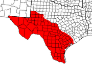
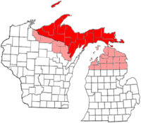
- The State of Shasta (1852); State of Klamath (1853); followed by the State of Jefferson (1854) for virtually the same Pacific northwest areas
- State of Superior or Sylvania, 1858
- Jefferson State
- Jefferson StateJefferson (Mountain state)Jefferson was a proposed American state in the Southern Rocky Mountains. On September 24, 1859, voters defeated the formation of this proposed State....
, 1859 (see Jefferson TerritoryJefferson TerritoryThe Provisional Government of the Territory of Jefferson was an extralegal and unrecognized United States territory that existed from October 24, 1859 until the creation of the Colorado Territory on February 28, 1861...
) - Southern Jefferson State,1870 and 1915
- Jefferson State
- State of KanawhaState of KanawhaKanawha was a proposed name for what later became the U.S. state of West Virginia, formed on October 24, 1861. It consisted of most of the northwestern counties of Virginia, which decided to secede from Virginia after Virginia joined the Confederate States of America on April 17, 1861 at the...
(see West Virginia), 1861 - State of Lincoln
- Northwestern State of Lincoln, 1868 (see Wyoming Territory)
- Southern State of LincolnLincoln (Southern US state)The State of Lincoln was proposed in 1869 after the U.S. Civil War to be carved out of the territory of Texas from the area south and west of the state's Colorado River...
,1869
- State of SequoyahState of SequoyahThe State of Sequoyah was the proposed name for a state to be established in the eastern part of present-day Oklahoma. In 1905, faced by proposals to end their tribal governments, Native Americans of the Five Civilized Tribes in Indian Territory proposed such a state as a means to retain some...
, 1905
Native American-related regions
- AztlanAztlánAztlán is the mythical ancestral home of the Nahua peoples, one of the main cultural groups in Mesoamerica. And, by extension, is the mythical homeland of the Uto-Aztecan peoples. Aztec is the Nahuatl word for "people from Aztlan".-Legend:...
(a future reincarnation of a defunct, mythical Aztec Empire to be "re"-established in lands now found in the Southwestern U.S., a central theme in ChicanoChicanoThe terms "Chicano" and "Chicana" are used in reference to U.S. citizens of Mexican descent. However, those terms have a wide range of meanings in various parts of the world. The term began to be widely used during the Chicano Movement, mainly among Mexican Americans, especially in the movement's...
political activism.) - ComancheriaComancheriaThe Comancheria is the name commonly given to the region of New Mexico, west Texas and nearby areas occupied by the Comanche before the 1860s.-Geography:...
, area inhabited and intermittently controlled by the Comanche and their allies. - DinétahDinetahDinétah is the traditional homeland of the Navajo tribe of Native Americans. In the Navajo language, the word means "among the people" or "among the Navajo"...
, the original Navajo homeland - Republic of LakotahRepublic of LakotahThe Republic of Lakotah or Lakotah is a proposed country in North America to serve as a homeland for the Lakota.Its boundaries would be surrounded by the borders of the United States, covering thousands of square miles in North Dakota, South Dakota, Nebraska, Wyoming, and Montana...
, the proposed upper midwestern U.S. Sioux mega-state. - LenapehokingLenapehokingLenapehoking is a term for the lands historically inhabited by the Native American people known as the Lenape in what is now the Northeastern United States...
, named for the Delaware or Lenilenape Indians.
Regional nicknames
- AppalachiaAppalachiaAppalachia is a term used to describe a cultural region in the eastern United States that stretches from the Southern Tier of New York state to northern Alabama, Mississippi, and Georgia. While the Appalachian Mountains stretch from Belle Isle in Canada to Cheaha Mountain in the U.S...
- Border States
- The Burnt-Over District
- The Deep SouthDeep SouthThe Deep South is a descriptive category of the cultural and geographic subregions in the American South. Historically, it is differentiated from the "Upper South" as being the states which were most dependent on plantation type agriculture during the pre-Civil War period...
- The Dust BowlDust BowlThe Dust Bowl, or the Dirty Thirties, was a period of severe dust storms causing major ecological and agricultural damage to American and Canadian prairie lands from 1930 to 1936...
- The East CoastEast Coast of the United StatesThe East Coast of the United States, also known as the Eastern Seaboard, refers to the easternmost coastal states in the United States, which touch the Atlantic Ocean and stretch up to Canada. The term includes the U.S...
- The Great PlainsGreat PlainsThe Great Plains are a broad expanse of flat land, much of it covered in prairie, steppe and grassland, which lies west of the Mississippi River and east of the Rocky Mountains in the United States and Canada. This area covers parts of the U.S...
- The Inland Empire
- Little Egypt
- The MidwestMidwestern United StatesThe Midwestern United States is one of the four U.S. geographic regions defined by the United States Census Bureau, providing an official definition of the American Midwest....
- New EnglandNew EnglandNew England is a region in the northeastern corner of the United States consisting of the six states of Maine, New Hampshire, Vermont, Massachusetts, Rhode Island, and Connecticut...
- The NortheastNortheastern United StatesThe Northeastern United States is a region of the United States as defined by the United States Census Bureau.-Composition:The region comprises nine states: the New England states of Connecticut, Maine, Massachusetts, New Hampshire, Rhode Island and Vermont; and the Mid-Atlantic states of New...
- The RockiesRocky MountainsThe Rocky Mountains are a major mountain range in western North America. The Rocky Mountains stretch more than from the northernmost part of British Columbia, in western Canada, to New Mexico, in the southwestern United States...
- The SouthSouthern United StatesThe Southern United States—commonly referred to as the American South, Dixie, or simply the South—constitutes a large distinctive area in the southeastern and south-central United States...
- The West CoastWest Coast of the United StatesWest Coast or Pacific Coast are terms for the westernmost coastal states of the United States. The term most often refers to the states of California, Oregon, and Washington. Although not part of the contiguous United States, Alaska and Hawaii do border the Pacific Ocean but can't be included in...
- The WestWestern United States.The Western United States, commonly referred to as the American West or simply "the West," traditionally refers to the region comprising the westernmost states of the United States. Because the U.S. expanded westward after its founding, the meaning of the West has evolved over time...
Belts
- Bible BeltBible BeltBible Belt is an informal term for a region in the southeastern and south-central United States in which socially conservative evangelical Protestantism is a significant part of the culture and Christian church attendance across the denominations is generally higher than the nation's average.The...
- Black BeltBlack Belt (U.S. region)The Black Belt is a region of the Southern United States. Although the term originally described the prairies and dark soil of central Alabama and northeast Mississippi, it has long been used to describe a broad agricultural region in the American South characterized by a history of plantation...
- Borscht BeltBorscht BeltBorscht Belt, or Jewish Alps, is a colloquial term for the mostly defunct summer resorts of the Catskill Mountains in parts of Sullivan, Orange and Ulster counties in upstate New York that were a popular vacation spot for New York City Jews from the 1920s through the 1960s.-Name:The name comes from...
- Frost BeltFrost BeltThe Frost Belt is a region of the United States generally considered to include the Northeastern United States, the Great Lakes Region, and much of the Upper Midwest. The region is known for its cold, frost-producing winters and heavy snowfall....
- Grain Belt or Corn Belt
- Mormon CorridorMormon CorridorThe Mormon Corridor is a term for the areas of Western North America that were settled between 1850 and approximately 1890 by members of The Church of Jesus Christ of Latter-day Saints , who are commonly known as Mormons....
or "Jello Belt" - Lead BeltLead BeltThe Southeast Missouri Lead District, commonly called the Lead Belt, is a lead mining district in the southeastern part of Missouri. Counties in the Lead Belt include Saint Francois; Crawford; Dent; Iron; Madison: Reynolds; and Washington...
- Rust BeltRust BeltThe Rust Belt is a term that gained currency in the 1980s as the informal description of an area straddling the Midwestern and Northeastern United States, in which local economies traditionally garnered an increased manufacturing sector to add jobs and corporate profits...
- Snow BeltSnowbeltSnowbelt is a term describing of a number of regions near the Great Lakes in North America where heavy snowfall in the form of lake-effect snow is particularly common. Snowbelts are typically found downwind of the lakes, principally off the eastern and southern shores...
- Sun BeltSun BeltThe Sun Belt or Spanish Belt is a region of the United States generally considered to stretch across the South and Southwest . Another rough boundary of the region is the area south of the 36th parallel, north latitude. It is the largest region which the U.S government does not recognize officially...
- Tornado AlleyTornado AlleyTornado Alley is a colloquial and popular media term that most often refers to the area of the United States where tornadoes are most frequent. Although an official location is not defined, the area between the Rocky Mountains and Appalachian Mountains is usually associated with it.The areas...
See also
- European colonization of the AmericasEuropean colonization of the AmericasThe start of the European colonization of the Americas is typically dated to 1492. The first Europeans to reach the Americas were the Vikings during the 11th century, who established several colonies in Greenland and one short-lived settlement in present day Newfoundland...
- List of former United States counties
- List of regions of the United States
- List of U.S. state partition proposals
- List of U.S. states that were never territories
- Political divisions of the United StatesPolitical divisions of the United StatesThe political units and divisions of the United States include:*The 50 states are subdivided into counties . The counties may be further subdivided into townships, or towns in New York and New England...
External links
- Official Name and Status History of the several States and U.S. Territories http://www.thegreenpapers.com/slg/statehood.phtml
- Indian Land Cessions in the United States, 1784-1894; United States Serial Set, Number 4015 http://memory.loc.gov/ammem/amlaw/lwss-ilc.html
- United States Territorial Maps 1775-1920 http://xroads.virginia.edu/~MAP/terr_hp.html
- Spanish Luisiana http://www.artifacts.org/Luisiana.htm