

Congress Lands
Encyclopedia
The Congress Lands was a group of land tracts in Ohio
that made land available for sale to members of the general public through land offices in various cities, and through the General Land Office
. It consisted of three groups of surveys:
called Ranges. These ranges were numbered from Ellicott’s Line
, the boundary between Ohio and Pennsylvania
, also known as the Eastern Ohio Meridian
. The townships within each range were surveyed north and south from the baseline
called the “Geographer’s Line” at 40 degrees 38 minutes north, which runs west from the north bank of the Ohio River
where it exits Pennsylvania, at a place now called the Beginning Point of the U.S. Public Land Survey
. The townships were not numbered from the baseline, but from south to north beginning with the first partial township in each range formed next to the Ohio River. Thus, townships in adjacent ranges rarely had the same number. This system extended the original numbering plan from the Seven Ranges
. There being no east ranges or south townships, plats are designated “Township X of Range Y of Ohio River Survey” with no need for north or west designations. Surveys on the Ohio River Base also consist of the Ohio Company
and the Seven Ranges. The Seven Ranges were sold in the same manner, and could be considered Congress Lands, but get a special category to itself.
and Indiana
, and south of the Greenville Treaty Line. Ranges are designated as east of the First Principal Meridian
which is at the Ohio-Indiana border. Townships are numbered from south to north, with irregularities caused by the course of the Great Miami River.
and the Congress Lands North of Old Seven Ranges, North of the Greenville Treaty Line and the Virginia Military District
, and east of Indiana. Townships are surveyed north and south from the baseline at 41 degrees north, and are designated “Township X N, Range Y E of First Principal Meridian” or “Township X S, Range Y E of First Principal Meridian”.
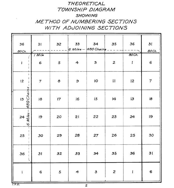 In all five of Ohio’s Congress Lands, townships are divided into 36 one mile square sections
. These sections are numbered by the method established May 18, 1796. Section sixteen of each survey township was set aside for support of public schools
.
or the Refugee Tract
were made available for sale through the various Land Offices, and treated the same as Congress Lands.
Ohio
Ohio is a Midwestern state in the United States. The 34th largest state by area in the U.S.,it is the 7th‑most populous with over 11.5 million residents, containing several major American cities and seven metropolitan areas with populations of 500,000 or more.The state's capital is Columbus...
that made land available for sale to members of the general public through land offices in various cities, and through the General Land Office
General Land Office
The General Land Office was an independent agency of the United States government responsible for public domain lands in the United States. It was created in 1812 to take over functions previously conducted by the United States Department of the Treasury...
. It consisted of three groups of surveys:
- Ohio River Base
- Congress Lands East of Scioto RiverCongress Lands East of Scioto RiverThe Congress Lands East of Scioto River was a land tract in southern Ohio that was established by the Congress late in the 18th century. It is located south of the United States Military District and Refugee Tract, west of the Old Seven Ranges, east of the Virginia Military District and north of...
- Congress Lands North of Old Seven RangesCongress Lands North of Old Seven RangesThe Congress Lands North of the Old Seven Ranges was a land tract in northeast Ohio that was established by the Congress early in the 19th century...
- Congress Lands East of Scioto River
- Congress Lands West of Miami RiverCongress Lands West of Miami RiverThe Congress Lands West of Miami River was a land tract in southwest Ohio that was established by the Congress late in the 18th century. It is located south of the Greenville Treaty Line, east of Indiana, and north of the Great Miami River...
- Northwest Ohio
- North and East of the First Principal Meridian
- South and East of the First Principal MeridianSouth and East of the First Principal MeridianSouth and East of the First Principal Meridian is a land description in the American Midwest.In 1812, Congress authorized the Surveyor General to survey the northern and western border of Ohio “as soon as the consent of the Indians can be obtained.“ In 1817, the northern portion of the Ohio-Indiana...
Ohio River Base
The Ohio River Base consisted of the Congress Lands East of Scioto River, and Congress Lands North of Old Seven Ranges. These surveys had vertical rows of six mile square townshipsSurvey township
Survey township, sometimes called Congressional township, as used by the United States Public Land Survey System, refers to a square unit of land, that is nominally six miles on a side...
called Ranges. These ranges were numbered from Ellicott’s Line
Andrew Ellicott
Andrew Ellicott was a U.S. surveyor who helped map many of the territories west of the Appalachians, surveyed the boundaries of the District of Columbia, continued and completed Pierre Charles L'Enfant's work on the plan for Washington, D.C., and served as a teacher in survey methods for...
, the boundary between Ohio and Pennsylvania
Pennsylvania
The Commonwealth of Pennsylvania is a U.S. state that is located in the Northeastern and Mid-Atlantic regions of the United States. The state borders Delaware and Maryland to the south, West Virginia to the southwest, Ohio to the west, New York and Ontario, Canada, to the north, and New Jersey to...
, also known as the Eastern Ohio Meridian
Meridian (geography)
A meridian is an imaginary line on the Earth's surface from the North Pole to the South Pole that connects all locations along it with a given longitude. The position of a point along the meridian is given by its latitude. Each meridian is perpendicular to all circles of latitude...
. The townships within each range were surveyed north and south from the baseline
Baseline (surveying)
In the United States Public Land Survey System, a baseline is the principal east-west line that divides survey townships between north and south. The baseline meets its corresponding meridian at the point of origin, or initial point, for the land survey...
called the “Geographer’s Line” at 40 degrees 38 minutes north, which runs west from the north bank of the Ohio River
Ohio River
The Ohio River is the largest tributary, by volume, of the Mississippi River. At the confluence, the Ohio is even bigger than the Mississippi and, thus, is hydrologically the main stream of the whole river system, including the Allegheny River further upstream...
where it exits Pennsylvania, at a place now called the Beginning Point of the U.S. Public Land Survey
Beginning Point of the U.S. Public Land Survey
The Beginning Point of the U.S. Public Land Survey is a monument at the border between the U.S. states of Ohio and Pennsylvania, on the north side of the Ohio River. It is near the three-way intersection of Ohio, Pennsylvania, and the northern tip of West Virginia, in both the Pittsburgh...
. The townships were not numbered from the baseline, but from south to north beginning with the first partial township in each range formed next to the Ohio River. Thus, townships in adjacent ranges rarely had the same number. This system extended the original numbering plan from the Seven Ranges
Seven Ranges
The Seven Ranges was a land tract in eastern Ohio that was the first tract to be surveyed in what became the Public Land Survey System. The tract is across the northern edge, on the western edge, with the south and east sides along the Ohio River...
. There being no east ranges or south townships, plats are designated “Township X of Range Y of Ohio River Survey” with no need for north or west designations. Surveys on the Ohio River Base also consist of the Ohio Company
Ohio Company of Associates
The Ohio Company of Associates, also known as the Ohio Company, was a land company which is today credited with becoming the first non-American Indian group to settle in the present-day state of Ohio...
and the Seven Ranges. The Seven Ranges were sold in the same manner, and could be considered Congress Lands, but get a special category to itself.
Congress Lands West of Miami River
The Congress Lands West of Miami River consists of lands between the Great Miami RiverGreat Miami River
The Great Miami River is a tributary of the Ohio River, approximately long, in southwestern Ohio in the United States...
and Indiana
Indiana
Indiana is a US state, admitted to the United States as the 19th on December 11, 1816. It is located in the Midwestern United States and Great Lakes Region. With 6,483,802 residents, the state is ranked 15th in population and 16th in population density. Indiana is ranked 38th in land area and is...
, and south of the Greenville Treaty Line. Ranges are designated as east of the First Principal Meridian
First Principal Meridian
The First Principal Meridian is a meridian that began at the junction of the Ohio River and Great Miami River. It extends north on the boundary line between the states of Ohio and Indiana, and roughly approximates to the meridian of longitude 84° 48' 50" west from Greenwich...
which is at the Ohio-Indiana border. Townships are numbered from south to north, with irregularities caused by the course of the Great Miami River.
Northwest Ohio
Congress Lands in northwest Ohio consist of North and East of the First Principal Meridian and South and East of the First Principal Meridian. These lands are south of a narrow strip next to the Michigan border, west of the FirelandsFirelands
The Firelands or Sufferers' Lands tract was located at the western end of the Connecticut Western Reserve in what is now the U.S. state of Ohio...
and the Congress Lands North of Old Seven Ranges, North of the Greenville Treaty Line and the Virginia Military District
Virginia Military District
The Virginia Military District was an approximately 4.2 million acre area of land in what is now the state of Ohio that was reserved by Virginia to use as payment for veterans of the American Revolutionary War....
, and east of Indiana. Townships are surveyed north and south from the baseline at 41 degrees north, and are designated “Township X N, Range Y E of First Principal Meridian” or “Township X S, Range Y E of First Principal Meridian”.
Township Subdivision
Section (United States land surveying)
In U.S. land surveying under the Public Land Survey System , a section is an area nominally one square mile, containing , with 36 sections making up one survey township on a rectangular grid....
. These sections are numbered by the method established May 18, 1796. Section sixteen of each survey township was set aside for support of public schools
School Lands
The School Lands are part of the Ohio Lands, comprising land grants in Ohio from the United States federal government for public schools. Support for public education in the United States predates the constitution; two years before the adoption of the United States Constitution of 1787, the...
.
Other Lands
Lands that were not dispersed in the United States Military DistrictUnited States Military District
The United States Military District was a land tract in central Ohio that was established by the Congress to compensate veterans of the American Revolutionary War for their service...
or the Refugee Tract
Refugee Tract
The Refugee Tract is an area of land in Ohio, United States granted to people from British Canada who left home prior to July 4, 1776, stayed in the US until November 25, 1783 continuously, and aided the revolutionary cause.-Location:...
were made available for sale through the various Land Offices, and treated the same as Congress Lands.