

Geography of the Republic of Macedonia
Encyclopedia
The Republic of Macedonia
is a country situated in southeastern
Europe with geographic coordinates
41°50′N 22°00′E, bordering Kosovo
and Serbia
to the north, Bulgaria
to the east, Greece
to the south and Albania
to the west. The country is part of the wider region of Macedonia
and makes up most of Vardar Macedonia
. The country is a major transportation corridor from Western
and Central Europe
to Southern Europe
and the Aegean Sea
. Macedonia is a landlocked country but has three major natural lakes: Lake Ohrid
, Lake Prespa
and Lake Dojran. It has a water area of 857 km2, while its land area is 24,856 km2.
Phytogeographically
, Macedonia belongs to the Illyrian province of the Circumboreal Region
within the Boreal Kingdom
. According to the WWF
and Digital Map of European Ecological Regions by the European Environment Agency
, Macedonia's territory can be subdivided into four ecoregion
s: the Pindus Mountains
mixed forests
, Balkan
mixed forests
, Rhodopes
mixed forests
and Aegean
sclerophyll
ous and mixed forests
.
combined with the influence of the Black Sea
. The country also holds continental characteristics, which are accentuated by the mountains in the south which prevent hot air from the south to move to the north. Conversely, the Šar Mountains, which are located in the northwestern part, block cold northern winds. In whole, the northern and western parts of the country are relatively close to Continental climate
and the southern and eastern to Mediterranean climate.
Macedonia has four seasons weather, but the lengths of the seasons varies based on geography. The spring is often very short. Summers are subtropical so it is not uncommon to see temperatures of above 40 °C (104 °F) during this season, especially in the plains along the valley of the Vardar
river. Winters, although moderate, can sometimes be quite cold. Snowfalls during winter are common and sometimes heavy. The average annual temperature of the air is 11.5 °C (53 °F), but the plains experience higher temperatures, 15 °C (59 °F). The warmest month is July, which has an average temperature of 22.2 °C (72 °F) and the coldest is January, with a temperature of 0.3 °C (33 °F). The maximum and minimum temperatures recorded in Macedonia to date are 44.5 °C (112 °F) and -31.5 °C, respectively.
The rainfall is abundant in the western and eastern parts of the country, but the temperature decreases significantly in the Vardar region. This region sees warmer winters through the Vardarec wind. This wind comes up from the mouth of the Vardar river and brings warm air. Skopje, considered a low-lying city, has an average of 64 rainy days per year. The month of October is the wettest with 61 mm; the driest is August with 28 mm. Rains are most common in the spring and fall.
Climate Facts:
Climatic data for Skopje :
The north border with Serbia and Kosovo is 221 kilometers in length. The border was made after World War II, between SR Macedonia and SR Serbia. But in 2008 when Kosovo self-declared independence the border with it was remarked again. Rather more than half of the boundary separates Macedonia from Kosovo. From the tripoint with Albania, the boundary trends north-eastwards along the watershed of Šar Mountain
. It describes a curve to the south across the River Lepenec and then turns to north-east to traverse Mount Crna before taking a course slightly to the north of east across the landscape features to the tripoint with Bulgaria.
 The east border with Bulgaria has length of approximately 148 km. The settled boundary from Yugoslavia and the People's Republic of Bulgaria was accepted after the independence in 1992. The boundary starts from the tripoint with Greece, the boundary runs north, crossing the River of Strumica
and then rising to the watershed which it follows northwards and then north-westwards to the tripoint with Serbia.
The south border that splits Macedonia from Greece is 228 km long and it is the longest Macedonian border. The border was marked with the Treaty of Bucharest on 10 August 1913. The border starts from the tripoint with Albania, in Lake Prespa
, the boundary runs in a straight line eastwards across the lake and then continues in the north of east trend across the relief to the Voras Oros, where it turns north-eastwards. It traverses the watershed of the Voras Oros and then continues eastwards along the watershed before dropping to the valley of Vardar river. The boundary continues eastwards and then turns north across the Dojran lake
, before, on the latitude of Valandovo
, turning east to the tripoint with Bulgaria on Mount Tumba.
The boundary with Albania that is long 151 km was marked first in 1926 and then remarked with the Treaty of Paris
in 1947. The boundary starts from the tripoint with Kosovo and it follows a watershed before crossing, and for a short distance, following the Black Drin
river and continuing along a crest line to Ohrid Lake. It crosses the lake, leaving approximately one-third in Albania, traverses a high ridge and "meets" the tripoint with Greece in Lake Prespa.
, which frame the valley of the Vardar
river. Three large lakes — Lake Ohrid, Lake Prespa and Dojran Lake — lie on the southern borders, bisected by the frontiers with Albania and Greece. Ohrid is considered to be one of the oldest lakes and biotopes in the world. The region is seismically active and has been the site of destructive earthquakes in the past, most recently in 1963 when Skopje was heavily damaged by a major earthquake, killing over 1,000.
Macedonia also has scenic mountains. They belong to two different mountain range
s: the first is the Šar Mountains that continues to the West Vardar/Pelagonia group of mountains (Baba Mountain, Nidže
, Kozuf
and Jakupica
), also known as the Dinaric range
. The second range is the Osogovo
–Belasica
mountain chain, also known as the Rhodope range
. The mountains belonging to the Šar Mountains and the West Vardar/Pelagonia range are younger and higher than the older mountains that are part of the Osogovo-Belasica mountain group. The ten highest mountains in Macedonia are:
 In the Republic of Macedonia there are 1,100 larger sources of water. The rivers flow into three different basins: the Aegean, the Adriatic
and that Black Sea
basin.
The Aegean basin is the largest. It covers 87% of the territory of the Republic, which is 22,075 km. sq. Vardar
, the largest river in this basin, drains 80% of the territory or 20,459 km. sq. Its valley plays an important part in the economy and the communication system of the country. The project named The Vardar Valley is considered to be crucial for the strategic development of the country.
The river Black Drim) forms the Adriatic basin, which covers an area of about 3,320 km. sq., i. e. 13% of the territory. It issues from Lakes Prespa and Ohrid.
The Black Sea basin is the smallest with only 37 km. sq. It covers the northern side of Mount Skopska Crna Gora
. Here is the source of the river Binačka Morava which joins the South Morava and later the Danube
, which eventually flows into the Black Sea
.
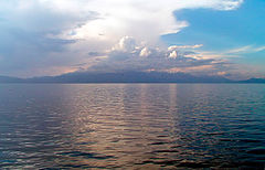
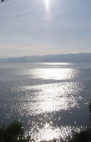
Despite being a landlocked country, Macedonia has three large lakes (Ohrid
, Prespa
, and Dojran), three artificial lakes and roughly 50 ponds.
There are nine spa resorts in Macedonia: Banište, Banja Bansko, Istibanja, Katlanovo, Kežovica
, Kosovrasti, Banja Kočani, Kumanovski Banji and Negorci.
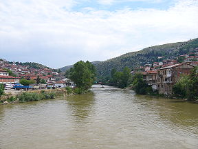 The Vardar is the longest and most important river in the Republic of Macedonia. It is 388 km (241.1 mi) long, and drains an area of around 25000 km² (9,652.6 sq mi).
The river rises at Vrutok, a few kilometers north of Gostivar
in the Republic of Macedonia. It passes through Gostivar, Skopje and into Veles, crosses the Greek border near Gevgelija
, Polykastro
and Axioupoli
, before emptying into the Aegean Sea in Central Macedonia
west of Thessaloniki
in northern Greece.
The Vardar basin includes two-thirds of the territory of the Republic of Macedonia. For that the area is called "Vardar Macedonia" after the river, to distinguish it from "Aegean Macedonia" (in Greece) and "Pirin Macedonia" (in Bulgaria).
The valley comprises fertile lands in Polog
, Gevgelija and other parts. The river is surrounded by mountains elsewhere. The M1 / E75, connecting with Greek National Road 1
, runs through the valley along the river's entire length to near Skopje.
The river is depicted on the coat of arms of Skopje, which in turn is incorporated in the city's flag.
 Lake Ohrid (Macedonian: Охридско Езеро, Ohridsko Ezero) straddles the mountainous border between the southwestern Republic of Macedonia and eastern Albania. Lake Ohrid is the deepest lake of the Balkans
, with a maximum depth of 288 m (940 ft) and a mean depth of 155 m (508 ft). It covers an area of 358 km² (138.2 sq mi), containing an estimated 55.4 km³ of water. It is 30.4 km long by 14.8 km wide at its maximum extent with a shoreline length of 87.53 km, shared between the Republic of Macedonia (56.02 km) and Albania (31.51 km). The lake drains an area of around 2600 km² and is fed primarily by underground springs on the eastern shore (about 50% of total inflow), with roughly 25% shares from rivers and direct precipitation. Over 20% of the lake's water comes from nearby Lake Prespa, about 10 km (6.2 mi) to the southeast and at 150 m higher altitude than Lake Ohrid.
While Lake Ohrid is special as such, by far the most spectacular quality is its impressive endemism. Similar to Lake Baikal
or Lake Tanganyika
, Lake Ohrid harbors endemic species covering the whole food-chain, from phytoplankton
and sestile algae (20 species; e.g., Cyclotella fottii), over plant species (2 species; e.g., Chara ohridana), zooplankton (5 species; e.g., Cyclops ochridanus), cyprinid
fish (8 species; e.g., Pachychilon pictus), to predatory fish (2 trout species; Ohrid trout Salmo letnica and "Belvica" Acantholingua ohridana) and finally its diverse endemic bottom fauna (176 species; e.g. Ochridagammarus solidus), with particularly large endemism among crustacean
s, molluscs, sponges and planarians.
There are three cities on the lake's shores: Ohrid
and Struga
on the Macedonian side; Pogradec
in Albania. There are also several fishing villages, although tourism is now a more significant part of their income. The catchment area of the lake has a population of around 170,000 people, with 131,000 people living directly at the lake shore (43,000 in Albania and 88,000 in the Republic of Macedonia).
("Large Town"), or Snake Island (Zmiski Ostrov). The other island Mal Grad (Small Town, in Albania) is the site of a ruined 14th century monastery dedicated to St. Peter. Today, both islands are uninhabited.
Because Great Prespa Lake sits about 150m above Lake Ohrid, which lies only about 10 km (6.2 mi) to the west, its waters run through underground channels in the karst and emerge from springs which feed streams running into Lake Ohrid.
(15.6 km²). The town of Dojran
is situated on the west coast of tha lake, while the Greek village of Mouries
lies to the east. To the north is the mountain Belasica
and to the south is the Greek town of Doirani
. The lake is round in shape, has a maximum depth of 10 metres, has a north-to-south length of 8.9 km, and is 7.1 km at its widest.
 The flora of Macedonia is represented with around 210 families
, 920 genera, and around 3,700 plant species
. The most abundant group are the flowering plant
s with around 3,200 species, which is followed by mosses (350 species) and fern
s (42).
Phytogeographically
, Macedonia belongs to the Illyrian province of the Circumboreal Region
within the Boreal Kingdom
. According to the WWF
and Digital Map of European Ecological Regions by the European Environment Agency
, the territory of the Republic can be subdivided into four ecoregion
s: the Pindus Mountains mixed forests, Balkan mixed forests, Rhodopes mixed forests and Aegean
sclerophyllous and mixed forests.
The fauna of Macedonian forests is abundant and includes bears, wild boars, wolves, foxes, squirrel
s, chamois
and deer
. The lynx
is found, although very rarely, in the mountains of western Macedonia, while deer can be found in the region of Demir Kapija
. Forest birds include the blackcap
, the grouse
, the black grouse
, the imperial eagle
and the forest owl.
The three artificial lakes of the country represent a separate fauna zone, an indication of long-lasting territorial and temporal isolation. The fauna of Lake Ohrid is a relict of an earlier era and the lake is widely known for its letnica trout, lake whitefish
, gudgeon
, roach
, podust, and pior, as well as for certain species of snails of a genus older than 30 million years; similar species can only be found in Lake Baikal
. Lake Ohrid is also noted in zoology texts for the European eel
and its baffling reproductive cycle: it comes to Lake Ohrid from the distant Sargasso Sea
, thousands of kilometres away, and lurks in the depths of the lake for 10 years. When sexually mature, the eel is driven by unexplained instincts in the autumn to set off back to its point of birth. There it spawns and dies, leaving its offspring to seek out Lake Ohrid to begin the cycle anew.
, lead
, zinc
, manganese
, tungsten
, nickel
, low-grade iron
ore, asbestos
, sulfur
, timber
. Also it is one of possibly two places in the world where the Lorandite
mineral is found.
According to 1993 estimates, there are 830 km2 of irrigated land.
and Macedonia.
The environment is preserved in areas impractical and sparsely populated. In addition, the country has three major national parks, created under the Yugoslav
regime of 1948-1958. The parks of Pelister, Mavrovo and Galičica cover an area of 108250 acres (438.1 km²) and allow for the protection of natural areas by their exceptional geological setting, their fauna and flora. The ornithological reserve Ezerani, north of Lake Prespa
, is 2000 hectares big and is home to sixty animals protected by the Bern Convention
.
However, if it is protected where man has little access, nature is threatened the outskirts of towns and villages. Indeed, in order to make Macedonia, formerly rural and poor, a modern and prosperous country, the Yugoslav communist regime established many factories, often highly polluting. These factories, located mainly in the regions of Veles
and Skopje
are still functioning. The emissions of waste pollutants have decreased after 1991, when independence is, because many companies have gone bankrupt or have reduced their activity after the transition to a market economy.
The other danger of degradation of nature lies in waste. Indeed, only the city of Skopje has a processing center for household waste in the rest of the country, so they are left in open dumps. The lack of resources and political will behind these fatal neglect for the environment.
Macedonia is also experiencing serious problems in water management. The country, which has a hot and arid summer climate, however should be able to secure its water through its dams and its sources. In summer, water restrictions are common. The summer period is also marked by the devastation of forests by fire. In 2008, six million trees were planted in Macedonia to regenerate damaged forests.
The environmental degradation nevertheless mobilizes local groups and Macedonia is a signatory to international treaties like the Kyoto Protocol
.
The three national parks :
, with more than 500,000 inhabitants, is by far the largest city in the country. His region, one of the few plains of the country, includes several other important cities, like Tetovo
and Gostivar
. Bitola
, Prilep
and other significant cities, are located in the plain of Pelagonia
the south, which is the second home stand. The rest of the population is concentrated in the valley of the Vardar and the few other basins and plains of the country.
Urbanization
, which is developing very fast since the communist era of Yugoslavia, has led to uncontrolled and illegal constructions. The outskirts of Skopje account and neighborhoods that strongly resemble slums. Other cities have not grown as spectacular as the capital, which has won more than 300,000 inhabitants between 1948 and 1981. Bitola, Prilep and Kumanovo
, the three other major cities, did not exceed 30,000 inhabitants in 1948 and barely reached 100,000 people since. Kumanovo, which is the second city of Macedonia, had only 105,000 inhabitants in 2002, which is very big difference comparing it with the population of the capital Skopje - 506,000 inhabitants.
Population of the most populous Macedonian municipalities
are the largest ethnic group in the country, accounting for 64.2% of the total population, according to the 2002 census. They speak the Macedonian language
and most are Orthodox Christians. Ethnic Albanians
are the country's largest minority, making up one-quarter of the total population. They live mainly in the west and northwest. The Turks
, who comprise nearly 4% of the population, are mostly scattered, though they form a majority in two municipalities (Plasnica
and Centar Župa
). The Romani make up 2.7% of the population and are also concentrated throughout Macedonia, while the Serbs
, who form just under 2% of the total population, live mostly in the north of the country.
, Pelagonia
, Polog
, Vardar
, Eastern
, Southeastern
, Northeastern
and Southwestern
.
The country is further divided into 84 municipalities. Until 1996, there were 123 municipalities, but several laws aimed at increasing the rights of minorities decreased the number of municipalities and modified their overall role. Skopje, the nation's capital, is itself divided into ten municipalities.
. Since independence in 1991, Macedonia has suffered the transition to market economy. Greece, which believes that the republic is monopolising the cultural and historical heritage of Macedonia, imposed an embargo in 1993 and has prevented the country's accession to organisations like the European Union
and NATO.
In 1995, the Greek embargo was lifted and Macedonia was finally able to access the IMF and World Bank. The country still suffers, however, from its isolation and lack of foreign investment. In 2007, the unemployment rate was estimated at 32% and the black market provided about 20% of the Gross Domestic Product.
, between Belgrade
and Athens
, Tirana
and Sofia
, between the Adriatic and Black Sea
. The Vardar valley forms a natural corridor, which connects Greece to the rest of Europe. This corridor is crossed by the highway E75, which crosses in Europe and connects Scandinavia with Attica
. This highway has also been renovated in Macedonia with the European Agency for Reconstruction
, and the communication channels that connect the Adriatic to the Black Sea, called the Corridor VIII, were also upgraded and maintained through international assistance including the Italian one.
Macedonia is also rich with minerals. The country in fact has substantial deposits of chromium
and other nonferrous metals like copper
, zinc
, manganese
and nickel
. The country also has gypsum mines, marble
and granite
, located in Pelagonia
. Lignite
, provides 80% of the Macedonian electricity. In addition to mines and quarries, the country has large cement plants and large complexes of metal, created by the communist regime.
Agriculture
is encouraged by the significant water resources, managed by dams and canals. The presence of hot springs of volcanic origin can heat the greenhouses in winter, particularly in the Strumica
region, whose products include tomato
es and cucumber
s in the month of February. Different climates provide opportunities for various productions in the geographical area, so the vine
and tobacco
are operated in the south, the rice
in the region of Kočani
which is largely irrigated, and the wood industry is concentrated around Štip
. Agriculture contributes a significant share of exports, especially with the wine and tobacco. The low cost of labor also helps the textile industry.
 The Republic of Macedonia receives about 700,000 tourists annually and experiences a constant increase of visitors. The number of domestic tourists in the period from January to March 2008 compared to the same period of the previous year, increased 23.5%. While the number of foreign tourists in March 2008 compared to March 2007 increased 44.7%. In 2007, Lake Ohrid
had received about 250,000 domestic and foreign tourists. In February 2009, nearly 28,000 tourists, or 3.2% more than the same month last year, visited Macedonia. There was also an 8% increase in the number of foreign visitors to the country. The summer of 2009 was the city of Dojran
's best tourist season with 135,000 overnight visitors, an increase of 12.5% compared to the previous year.
The tourist capital of Macedonia, Ohrid
, has been listed as an UNESCO World Heritage Site
since 1979.
Republic of Macedonia
Macedonia , officially the Republic of Macedonia , is a country located in the central Balkan peninsula in Southeast Europe. It is one of the successor states of the former Yugoslavia, from which it declared independence in 1991...
is a country situated in southeastern
Balkans
The Balkans is a geopolitical and cultural region of southeastern Europe...
Europe with geographic coordinates
Geographic coordinate system
A geographic coordinate system is a coordinate system that enables every location on the Earth to be specified by a set of numbers. The coordinates are often chosen such that one of the numbers represent vertical position, and two or three of the numbers represent horizontal position...
41°50′N 22°00′E, bordering Kosovo
Kosovo
Kosovo is a region in southeastern Europe. Part of the Ottoman Empire for more than five centuries, later the Autonomous Province of Kosovo and Metohija within Serbia...
and Serbia
Serbia
Serbia , officially the Republic of Serbia , is a landlocked country located at the crossroads of Central and Southeast Europe, covering the southern part of the Carpathian basin and the central part of the Balkans...
to the north, Bulgaria
Bulgaria
Bulgaria , officially the Republic of Bulgaria , is a parliamentary democracy within a unitary constitutional republic in Southeast Europe. The country borders Romania to the north, Serbia and Macedonia to the west, Greece and Turkey to the south, as well as the Black Sea to the east...
to the east, Greece
Greece
Greece , officially the Hellenic Republic , and historically Hellas or the Republic of Greece in English, is a country in southeastern Europe....
to the south and Albania
Albania
Albania , officially known as the Republic of Albania , is a country in Southeastern Europe, in the Balkans region. It is bordered by Montenegro to the northwest, Kosovo to the northeast, the Republic of Macedonia to the east and Greece to the south and southeast. It has a coast on the Adriatic Sea...
to the west. The country is part of the wider region of Macedonia
Macedonia (region)
Macedonia is a geographical and historical region of the Balkan peninsula in southeastern Europe. Its boundaries have changed considerably over time, but nowadays the region is considered to include parts of five Balkan countries: Greece, the Republic of Macedonia, Bulgaria, Albania, Serbia, as...
and makes up most of Vardar Macedonia
Vardar Macedonia
Vardar Macedonia is an area in the north of the Macedonia . The borders of the area are those of the Republic of Macedonia. It covers an area of...
. The country is a major transportation corridor from Western
Western Europe
Western Europe is a loose term for the collection of countries in the western most region of the European continents, though this definition is context-dependent and carries cultural and political connotations. One definition describes Western Europe as a geographic entity—the region lying in the...
and Central Europe
Central Europe
Central Europe or alternatively Middle Europe is a region of the European continent lying between the variously defined areas of Eastern and Western Europe...
to Southern Europe
Southern Europe
The term Southern Europe, at its most general definition, is used to mean "all countries in the south of Europe". However, the concept, at different times, has had different meanings, providing additional political, linguistic and cultural context to the definition in addition to the typical...
and the Aegean Sea
Aegean Sea
The Aegean Sea[p] is an elongated embayment of the Mediterranean Sea located between the southern Balkan and Anatolian peninsulas, i.e., between the mainlands of Greece and Turkey. In the north, it is connected to the Marmara Sea and Black Sea by the Dardanelles and Bosporus...
. Macedonia is a landlocked country but has three major natural lakes: Lake Ohrid
Lake Ohrid
Lake Ohrid straddles the mountainous border between the southwestern Macedonia and eastern Albania. It is one of Europe's deepest and oldest lakes, preserving a unique aquatic ecosystem with more than 200 endemic species that is of worldwide importance...
, Lake Prespa
Lake Prespa
Prespa is the name of two freshwater lakes in southeast Europe, shared by Greece, Albania, and Macedonia. Of the total surface area, belongs to Macedonia, to Greece and to Albania...
and Lake Dojran. It has a water area of 857 km2, while its land area is 24,856 km2.
Phytogeographically
Phytogeography
Phytogeography , also called geobotany, is the branch of biogeography that is concerned with the geographic distribution of plant species...
, Macedonia belongs to the Illyrian province of the Circumboreal Region
Circumboreal Region
The Circumboreal Region is a floristic region within the Holarctic Kingdom in Eurasia and North America, as delineated by such geobotanists as Josias Braun-Blanquet and Armen Takhtajan....
within the Boreal Kingdom
Boreal Kingdom
The Boreal Kingdom or Holarctic Kingdom is a floristic kingdom identified by botanist Ronald Good , which includes the temperate to Arctic portions of North America and Eurasia. Its flora is inherited from the ancient supercontinent of Laurasia...
. According to the WWF
World Wide Fund for Nature
The World Wide Fund for Nature is an international non-governmental organization working on issues regarding the conservation, research and restoration of the environment, formerly named the World Wildlife Fund, which remains its official name in Canada and the United States...
and Digital Map of European Ecological Regions by the European Environment Agency
European Environment Agency
European Environment Agency is an agency of the European Union. Its task is to provide sound, independent information on the environment. It is a major information source for those involved in developing, adopting, implementing and evaluating environmental policy, and also the general public...
, Macedonia's territory can be subdivided into four ecoregion
Ecoregion
An ecoregion , sometimes called a bioregion, is an ecologically and geographically defined area that is smaller than an ecozone and larger than an ecosystem. Ecoregions cover relatively large areas of land or water, and contain characteristic, geographically distinct assemblages of natural...
s: the Pindus Mountains
Pindus
The Pindus mountain range is located in northern Greece and southern Albania. It is roughly 160 km long, with a maximum elevation of 2637 m . Because it runs along the border of Thessaly and Epirus, the Pindus range is often called the "spine of Greece"...
mixed forests
Temperate broadleaf and mixed forests
Mixed forests are a temperate and humid biome. The typical structure of these forests includes four layers. The uppermost layer is the canopy composed of tall mature trees ranging from 33 to 66 m high. Below the canopy is the three-layered, shade-tolerant understory that is roughly 9 to...
, Balkan
Balkans
The Balkans is a geopolitical and cultural region of southeastern Europe...
mixed forests
Temperate broadleaf and mixed forests
Mixed forests are a temperate and humid biome. The typical structure of these forests includes four layers. The uppermost layer is the canopy composed of tall mature trees ranging from 33 to 66 m high. Below the canopy is the three-layered, shade-tolerant understory that is roughly 9 to...
, Rhodopes
Rhodope Mountains
The Rhodopes are a mountain range in Southeastern Europe, with over 83% of its area in southern Bulgaria and the remainder in Greece. Its highest peak, Golyam Perelik , is the seventh highest Bulgarian mountain...
mixed forests
Temperate broadleaf and mixed forests
Mixed forests are a temperate and humid biome. The typical structure of these forests includes four layers. The uppermost layer is the canopy composed of tall mature trees ranging from 33 to 66 m high. Below the canopy is the three-layered, shade-tolerant understory that is roughly 9 to...
and Aegean
Aegean Sea
The Aegean Sea[p] is an elongated embayment of the Mediterranean Sea located between the southern Balkan and Anatolian peninsulas, i.e., between the mainlands of Greece and Turkey. In the north, it is connected to the Marmara Sea and Black Sea by the Dardanelles and Bosporus...
sclerophyll
Sclerophyll
Sclerophyll is the term for a type of vegetation that has hard leaves and short internodes . The word comes from the Greek sclero and phyllon ....
ous and mixed forests
Temperate broadleaf and mixed forests
Mixed forests are a temperate and humid biome. The typical structure of these forests includes four layers. The uppermost layer is the canopy composed of tall mature trees ranging from 33 to 66 m high. Below the canopy is the three-layered, shade-tolerant understory that is roughly 9 to...
.
Climate
Macedonia has unique climate explained by its location and topography. The climate of the plains is extraordinary - Mediterranean climateMediterranean climate
A Mediterranean climate is the climate typical of most of the lands in the Mediterranean Basin, and is a particular variety of subtropical climate...
combined with the influence of the Black Sea
Black Sea
The Black Sea is bounded by Europe, Anatolia and the Caucasus and is ultimately connected to the Atlantic Ocean via the Mediterranean and the Aegean seas and various straits. The Bosphorus strait connects it to the Sea of Marmara, and the strait of the Dardanelles connects that sea to the Aegean...
. The country also holds continental characteristics, which are accentuated by the mountains in the south which prevent hot air from the south to move to the north. Conversely, the Šar Mountains, which are located in the northwestern part, block cold northern winds. In whole, the northern and western parts of the country are relatively close to Continental climate
Continental climate
Continental climate is a climate characterized by important annual variation in temperature due to the lack of significant bodies of water nearby...
and the southern and eastern to Mediterranean climate.
Macedonia has four seasons weather, but the lengths of the seasons varies based on geography. The spring is often very short. Summers are subtropical so it is not uncommon to see temperatures of above 40 °C (104 °F) during this season, especially in the plains along the valley of the Vardar
Vardar
The Vardar or Axios is the longest and major river in the Republic of Macedonia and also a major river of Greece. It is long, and drains an area of around . The maximum depth of river is ....
river. Winters, although moderate, can sometimes be quite cold. Snowfalls during winter are common and sometimes heavy. The average annual temperature of the air is 11.5 °C (53 °F), but the plains experience higher temperatures, 15 °C (59 °F). The warmest month is July, which has an average temperature of 22.2 °C (72 °F) and the coldest is January, with a temperature of 0.3 °C (33 °F). The maximum and minimum temperatures recorded in Macedonia to date are 44.5 °C (112 °F) and -31.5 °C, respectively.
The rainfall is abundant in the western and eastern parts of the country, but the temperature decreases significantly in the Vardar region. This region sees warmer winters through the Vardarec wind. This wind comes up from the mouth of the Vardar river and brings warm air. Skopje, considered a low-lying city, has an average of 64 rainy days per year. The month of October is the wettest with 61 mm; the driest is August with 28 mm. Rains are most common in the spring and fall.
| Place | Region | Latitude | Longitude | Altitude (m) | Rainfall (mm) | Temperature (°C) |
|---|---|---|---|---|---|---|
| Skopje Skopje Skopje is the capital and largest city of the Republic of Macedonia with about a third of the total population. It is the country's political, cultural, economic, and academic centre... |
North of the valley of the Vardar | 42° 00’ | 21° 26’ | 245 | 940 | 13,5 |
| Kočani Kocani Kočani is a town away from Skopje, situated in the Eastern part of the Republic of Macedonia, with population of 28 330. The town of Kočani is the seat of Kočani Municipality.-Geography and population:... |
Eastern Macedonia | 41° 50’ | 22° 00’ | 400 | 538 | 12,9 |
| Lake Ohrid Lake Ohrid Lake Ohrid straddles the mountainous border between the southwestern Macedonia and eastern Albania. It is one of Europe's deepest and oldest lakes, preserving a unique aquatic ecosystem with more than 200 endemic species that is of worldwide importance... |
Southwest Macedonia | 41° 03’ | 20° 42’ | 693 | 759 | 11,4 |
| Month | Jan | Feb | Mar | Apr | May | Jun | Jul | Aug | Sep | Oct | Nov | Dec |
|---|---|---|---|---|---|---|---|---|---|---|---|---|
| Maximal temperature (°C) | 5 | 10 | 13 | 18 | 23 | 28 | 31 | 30 | 26 | 20 | 10 | 7 |
| Minimum temperature (°C) | -5 | 2 | 5 | 7 | 12 | 16 | 18 | 18 | 15 | 11 | 6 | -2 |
| Rainfall (average height in mm) | 100 | 103 | 113 | 175 | 201 | 123 | 132 | 102 | 109 | 127 | 124 | 141 |
Boundaries
The country has some 748 km of boundaries, shared with Kosovo (159 km or 99 mi) to the northwest, Serbia (62 km or 39 mi) to the North, Bulgaria (148 km) to the east, Greece (228 km) to the south, and Albania (151 km) to the west.The north border with Serbia and Kosovo is 221 kilometers in length. The border was made after World War II, between SR Macedonia and SR Serbia. But in 2008 when Kosovo self-declared independence the border with it was remarked again. Rather more than half of the boundary separates Macedonia from Kosovo. From the tripoint with Albania, the boundary trends north-eastwards along the watershed of Šar Mountain
Šar Mountain
The Šar Mountains , formerly known as the Shar Dagh , is a mountain range in the Balkans that extends from southern Kosovo and the northwest of the Republic of Macedonia to northeastern Albania.-Etymology:...
. It describes a curve to the south across the River Lepenec and then turns to north-east to traverse Mount Crna before taking a course slightly to the north of east across the landscape features to the tripoint with Bulgaria.
Strumica River
The Strumica or Strumeshnitsa is a river in the Republic of Macedonia and Bulgaria...
and then rising to the watershed which it follows northwards and then north-westwards to the tripoint with Serbia.
The south border that splits Macedonia from Greece is 228 km long and it is the longest Macedonian border. The border was marked with the Treaty of Bucharest on 10 August 1913. The border starts from the tripoint with Albania, in Lake Prespa
Lake Prespa
Prespa is the name of two freshwater lakes in southeast Europe, shared by Greece, Albania, and Macedonia. Of the total surface area, belongs to Macedonia, to Greece and to Albania...
, the boundary runs in a straight line eastwards across the lake and then continues in the north of east trend across the relief to the Voras Oros, where it turns north-eastwards. It traverses the watershed of the Voras Oros and then continues eastwards along the watershed before dropping to the valley of Vardar river. The boundary continues eastwards and then turns north across the Dojran lake
Dojran Lake
Dojran Lake is a lake with an area of 43.1 km² shared between the Republic of Macedonia and West Macedonia within Greek Macedonia, Greece . To the west is the city of Nov Dojran , to the east the village of Mouries, to the north the mountain Belasica/Beles and to the south the Greek town of...
, before, on the latitude of Valandovo
Valandovo
Valandovo is a city in southeastern Republic of Macedonia.The city is the seat of Valandovo Municipality.-Ancient History:Evidence of life can be found beginning in the 10th-7th centuries B.C. There is a settlement known as Mal Konstantinopol dating from Roman times, and the life in the Middle...
, turning east to the tripoint with Bulgaria on Mount Tumba.
The boundary with Albania that is long 151 km was marked first in 1926 and then remarked with the Treaty of Paris
Paris Peace Treaties, 1947
The Paris Peace Conference resulted in the Paris Peace Treaties signed on February 10, 1947. The victorious wartime Allied powers negotiated the details of treaties with Italy, Romania, Hungary, Bulgaria, and Finland .The...
in 1947. The boundary starts from the tripoint with Kosovo and it follows a watershed before crossing, and for a short distance, following the Black Drin
Black Drin
The Black Drin is a river in Albania and the Republic of Macedonia. It flows out of Lake Ohrid in Struga, Macedonia. After approximately it crosses the border to Albania, west of Debar. It merges with the White Drin in Kukës to form the Drin, which flows into the Adriatic Sea...
river and continuing along a crest line to Ohrid Lake. It crosses the lake, leaving approximately one-third in Albania, traverses a high ridge and "meets" the tripoint with Greece in Lake Prespa.
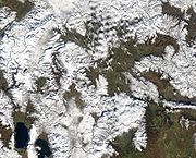
Topography
Macedonia is a landlocked country that is geographically clearly defined by a central valley formed by the Vardar river and framed along its borders by mountain ranges. The terrain is mostly rugged, located between the Šar Mountains and OsogovoOsogovo
Osogovo or Osogovska Planina is a mountain and ski resort between southwestern Bulgaria and northeastern Republic of Macedonia,...
, which frame the valley of the Vardar
Vardar
The Vardar or Axios is the longest and major river in the Republic of Macedonia and also a major river of Greece. It is long, and drains an area of around . The maximum depth of river is ....
river. Three large lakes — Lake Ohrid, Lake Prespa and Dojran Lake — lie on the southern borders, bisected by the frontiers with Albania and Greece. Ohrid is considered to be one of the oldest lakes and biotopes in the world. The region is seismically active and has been the site of destructive earthquakes in the past, most recently in 1963 when Skopje was heavily damaged by a major earthquake, killing over 1,000.
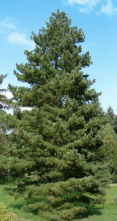
Macedonia also has scenic mountains. They belong to two different mountain range
Mountain range
A mountain range is a single, large mass consisting of a succession of mountains or narrowly spaced mountain ridges, with or without peaks, closely related in position, direction, formation, and age; a component part of a mountain system or of a mountain chain...
s: the first is the Šar Mountains that continues to the West Vardar/Pelagonia group of mountains (Baba Mountain, Nidže
Nidze
Nidže is a mountain in the southwest of the Republic of Macedonia. The mountain is characterised by almost untouched nature: rich pine forests, lomi, rivers and pastures over 2000 meters. The highest peak is Kajmakčalan at 2521 meters above sea level...
, Kozuf
Kožuf
Kožuf mountain is a mountain situated in the southern part of the Republic of Macedonia and partly in Greece. Its most western parts reach the river Blashnica, and the north-western side stretches in a line, from the Mrzhechko village via the village Konopishte, through the course of Boshava to...
and Jakupica
Jakupica
Jakupica is a mountain range in the central part of the Republic of Macedonia. Its highest peak is Solunska Glava . Other significant peaks are: Karadzica , Popovo Brdo , Ostar Breg , Ubava , Ostar Vrv , and Dautica .The relief is criss-crossed by numerous clear and fast mountain rivers...
), also known as the Dinaric range
Dinaric Alps
The Dinaric Alps or Dinarides form a mountain chain in Southern Europe, spanning areas of Slovenia, Croatia, Bosnia and Herzegovina, Serbia, Kosovo, Albania and Montenegro....
. The second range is the Osogovo
Osogovo
Osogovo or Osogovska Planina is a mountain and ski resort between southwestern Bulgaria and northeastern Republic of Macedonia,...
–Belasica
Belasica
Belasica is a mountain range in the region of Macedonia in Southeastern Europe, shared by northwestern Greece , southeastern Republic of Macedonia and southwestern Bulgaria...
mountain chain, also known as the Rhodope range
Rhodope Mountains
The Rhodopes are a mountain range in Southeastern Europe, with over 83% of its area in southern Bulgaria and the remainder in Greece. Its highest peak, Golyam Perelik , is the seventh highest Bulgarian mountain...
. The mountains belonging to the Šar Mountains and the West Vardar/Pelagonia range are younger and higher than the older mountains that are part of the Osogovo-Belasica mountain group. The ten highest mountains in Macedonia are:
Hydrography
Adriatic Sea
The Adriatic Sea is a body of water separating the Italian Peninsula from the Balkan peninsula, and the system of the Apennine Mountains from that of the Dinaric Alps and adjacent ranges...
and that Black Sea
Black Sea
The Black Sea is bounded by Europe, Anatolia and the Caucasus and is ultimately connected to the Atlantic Ocean via the Mediterranean and the Aegean seas and various straits. The Bosphorus strait connects it to the Sea of Marmara, and the strait of the Dardanelles connects that sea to the Aegean...
basin.
The Aegean basin is the largest. It covers 87% of the territory of the Republic, which is 22,075 km. sq. Vardar
Vardar
The Vardar or Axios is the longest and major river in the Republic of Macedonia and also a major river of Greece. It is long, and drains an area of around . The maximum depth of river is ....
, the largest river in this basin, drains 80% of the territory or 20,459 km. sq. Its valley plays an important part in the economy and the communication system of the country. The project named The Vardar Valley is considered to be crucial for the strategic development of the country.
The river Black Drim) forms the Adriatic basin, which covers an area of about 3,320 km. sq., i. e. 13% of the territory. It issues from Lakes Prespa and Ohrid.
The Black Sea basin is the smallest with only 37 km. sq. It covers the northern side of Mount Skopska Crna Gora
Skopska Crna Gora
Skopska Crna Gora , formerly called Kara-dagh also called simply Crna Gora, is a mountain range on the border between Kosovo and the Republic of Macedonia, between the cities of Kačanik and Skopje.The Monastery of St...
. Here is the source of the river Binačka Morava which joins the South Morava and later the Danube
Danube
The Danube is a river in the Central Europe and the Europe's second longest river after the Volga. It is classified as an international waterway....
, which eventually flows into the Black Sea
Black Sea
The Black Sea is bounded by Europe, Anatolia and the Caucasus and is ultimately connected to the Atlantic Ocean via the Mediterranean and the Aegean seas and various straits. The Bosphorus strait connects it to the Sea of Marmara, and the strait of the Dardanelles connects that sea to the Aegean...
.
Despite being a landlocked country, Macedonia has three large lakes (Ohrid
Lake Ohrid
Lake Ohrid straddles the mountainous border between the southwestern Macedonia and eastern Albania. It is one of Europe's deepest and oldest lakes, preserving a unique aquatic ecosystem with more than 200 endemic species that is of worldwide importance...
, Prespa
Lake Prespa
Prespa is the name of two freshwater lakes in southeast Europe, shared by Greece, Albania, and Macedonia. Of the total surface area, belongs to Macedonia, to Greece and to Albania...
, and Dojran), three artificial lakes and roughly 50 ponds.
There are nine spa resorts in Macedonia: Banište, Banja Bansko, Istibanja, Katlanovo, Kežovica
Kežovica
The Kežovica mineral spa is situated near the southern Štip suburb of Novo Selo, just after the canyon that the river Bregalnica forms when exiting the city. The water temperature is 74°C at the source and is slightly radioactive, which is used for medicinal purposes...
, Kosovrasti, Banja Kočani, Kumanovski Banji and Negorci.
River Vardar
The river rises at Vrutok, a few kilometers north of Gostivar
Gostivar
Gostivar , is a city in the Republic of Macedonia, located in the upper Polog valley region. It is one of the largest municipalities in the country with a population of 81,042, and the town also covers . Gostivar has good road and railway connections with the other cities in the region, such as...
in the Republic of Macedonia. It passes through Gostivar, Skopje and into Veles, crosses the Greek border near Gevgelija
Gevgelija
Gevgelija is a town with a population of 15,685 located in the very southeast of the Republic of Macedonia along the banks of the Vardar River, situated at the country's main border with Greece , the point which links the motorway from Skopje and three other former Yugoslav capitals with...
, Polykastro
Polykastro
Polykastro , is a town and a former municipality in Kilkis regional unit, Greece. Since the 2011 local government reform it is part of the municipality Paionia, of which it is a municipal unit, and the seat. The municipal unit of Polykastro has 12,000 inhabitants, and includes Polykastro and 23...
and Axioupoli
Axioupoli
Axioupoli , known until 1927 as Boymitsa , is a small town and a former municipality in the former Paionia Province of Kilkis regional unit, Greece. Since the 2011 local government reform it is part of the municipality Paionia, of which it is a municipal unit...
, before emptying into the Aegean Sea in Central Macedonia
Central Macedonia
Central Macedonia is one of the thirteen regions of Greece, consisting of the central part of the region of Macedonia. With a population of over 1.8 million, it is the second most populous in Greece after Attica.- Administration :...
west of Thessaloniki
Thessaloniki
Thessaloniki , historically also known as Thessalonica, Salonika or Salonica, is the second-largest city in Greece and the capital of the region of Central Macedonia as well as the capital of the Decentralized Administration of Macedonia and Thrace...
in northern Greece.
The Vardar basin includes two-thirds of the territory of the Republic of Macedonia. For that the area is called "Vardar Macedonia" after the river, to distinguish it from "Aegean Macedonia" (in Greece) and "Pirin Macedonia" (in Bulgaria).
The valley comprises fertile lands in Polog
Polog
Polog also known as the Polog Valley , is located in the north-western part of the Republic of Macedonia near the border with Serbia.It is divided into Upper and Lower Polog...
, Gevgelija and other parts. The river is surrounded by mountains elsewhere. The M1 / E75, connecting with Greek National Road 1
Greek National Road 1
The Greek Motorway 1 is a motorway, partly under construction, and the 2nd longest in Greece. It is the principal north-south road connection in Greece, connecting the country's capital Athens with the regions of Thessaly and Macedonia, as well as the country's second largest city,...
, runs through the valley along the river's entire length to near Skopje.
The river is depicted on the coat of arms of Skopje, which in turn is incorporated in the city's flag.
Lake Ohrid
Balkans
The Balkans is a geopolitical and cultural region of southeastern Europe...
, with a maximum depth of 288 m (940 ft) and a mean depth of 155 m (508 ft). It covers an area of 358 km² (138.2 sq mi), containing an estimated 55.4 km³ of water. It is 30.4 km long by 14.8 km wide at its maximum extent with a shoreline length of 87.53 km, shared between the Republic of Macedonia (56.02 km) and Albania (31.51 km). The lake drains an area of around 2600 km² and is fed primarily by underground springs on the eastern shore (about 50% of total inflow), with roughly 25% shares from rivers and direct precipitation. Over 20% of the lake's water comes from nearby Lake Prespa, about 10 km (6.2 mi) to the southeast and at 150 m higher altitude than Lake Ohrid.
While Lake Ohrid is special as such, by far the most spectacular quality is its impressive endemism. Similar to Lake Baikal
Lake Baikal
Lake Baikal is the world's oldest at 30 million years old and deepest lake with an average depth of 744.4 metres.Located in the south of the Russian region of Siberia, between Irkutsk Oblast to the northwest and the Buryat Republic to the southeast, it is the most voluminous freshwater lake in the...
or Lake Tanganyika
Lake Tanganyika
Lake Tanganyika is an African Great Lake. It is estimated to be the second largest freshwater lake in the world by volume, and the second deepest, after Lake Baikal in Siberia; it is also the world's longest freshwater lake...
, Lake Ohrid harbors endemic species covering the whole food-chain, from phytoplankton
Phytoplankton
Phytoplankton are the autotrophic component of the plankton community. The name comes from the Greek words φυτόν , meaning "plant", and πλαγκτός , meaning "wanderer" or "drifter". Most phytoplankton are too small to be individually seen with the unaided eye...
and sestile algae (20 species; e.g., Cyclotella fottii), over plant species (2 species; e.g., Chara ohridana), zooplankton (5 species; e.g., Cyclops ochridanus), cyprinid
Cyprinid
The family Cyprinidae, from the Ancient Greek kyprînos , consists of the carps, the true minnows, and their relatives . Commonly called the carp family or the minnow family, its members are also known as cyprinids...
fish (8 species; e.g., Pachychilon pictus), to predatory fish (2 trout species; Ohrid trout Salmo letnica and "Belvica" Acantholingua ohridana) and finally its diverse endemic bottom fauna (176 species; e.g. Ochridagammarus solidus), with particularly large endemism among crustacean
Crustacean
Crustaceans form a very large group of arthropods, usually treated as a subphylum, which includes such familiar animals as crabs, lobsters, crayfish, shrimp, krill and barnacles. The 50,000 described species range in size from Stygotantulus stocki at , to the Japanese spider crab with a leg span...
s, molluscs, sponges and planarians.
There are three cities on the lake's shores: Ohrid
Ohrid
Ohrid is a city on the eastern shore of Lake Ohrid in the Republic of Macedonia. It has about 42,000 inhabitants, making it the seventh largest city in the country. The city is the seat of Ohrid Municipality. Ohrid is notable for having once had 365 churches, one for each day of the year and has...
and Struga
Struga
Struga is a town and popular tourist destination situated in the south-western region of the Republic of Macedonia, lying on the shore of Lake Ohrid. The town of Struga is the seat of Struga Municipality.-Etymology:...
on the Macedonian side; Pogradec
Pogradec
Pogradec is a city in southeastern Albania, situated on the shores of Ohrid lake. It is the capital of the District of Pogradec, in the County of Korçë, located at 40.87°N and 20.70°E with a population of around 30,000 . The total area of the district is 725 km². Pogradec alone occupies about...
in Albania. There are also several fishing villages, although tourism is now a more significant part of their income. The catchment area of the lake has a population of around 170,000 people, with 131,000 people living directly at the lake shore (43,000 in Albania and 88,000 in the Republic of Macedonia).
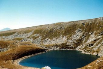
Lake Prespa
The Great Prespa Lake (Macedonian: Преспанско Езеро, Prespansko Ezero) is divided between Albania, Greece and the Republic of Macedonia. The biggest island in the Great Prespa Lake, on the Republic of Macedonia's side, is called Golem GradGolem Grad
Golem Grad , meaning Big City, also known as Snake Island, is an island in the Republic of Macedonia. The island covers an area of 18 hectares. It is located in Lake Prespa, a few kilometers from Greek and Albanian territory. Golem Grad is home to several ancient ruins and churches. It is also home...
("Large Town"), or Snake Island (Zmiski Ostrov). The other island Mal Grad (Small Town, in Albania) is the site of a ruined 14th century monastery dedicated to St. Peter. Today, both islands are uninhabited.
Because Great Prespa Lake sits about 150m above Lake Ohrid, which lies only about 10 km (6.2 mi) to the west, its waters run through underground channels in the karst and emerge from springs which feed streams running into Lake Ohrid.
Dojran Lake
Dojran Lake, located in southeastern Macedonia, is the smallest of the three major lakes with an area of 42.7 km². It is shared between the Republic of Macedonia (27.1 km²) and GreeceGreece
Greece , officially the Hellenic Republic , and historically Hellas or the Republic of Greece in English, is a country in southeastern Europe....
(15.6 km²). The town of Dojran
Dojran
Dojran was a city located on the western shore of Dojran Lake in the south-eastern part of the Republic of Macedonia. Today, it is collective name for two villages that exist on the territory of the ruined city: Nov Dojran and Star Dojran, which contains both old ruins and recent construction,...
is situated on the west coast of tha lake, while the Greek village of Mouries
Mouries
Mouries is a village and a former municipality in the Kilkis regional unit, northern Greece. Since the 2011 local government reform it is part of the municipality Kilkis, of which it is a municipal unit. Population 3,390 . The seat of the municipality was in Stathmos Mourion...
lies to the east. To the north is the mountain Belasica
Belasica
Belasica is a mountain range in the region of Macedonia in Southeastern Europe, shared by northwestern Greece , southeastern Republic of Macedonia and southwestern Bulgaria...
and to the south is the Greek town of Doirani
Doirani
Doirani is a former municipality in the Kilkis regional unit, Greece. Since the 2011 local government reform it is part of the municipality Kilkis, of which it is a municipal unit. It is situated on the shores of Dojran Lake, which marks the border between Greece and the Republic of Macedonia. It...
. The lake is round in shape, has a maximum depth of 10 metres, has a north-to-south length of 8.9 km, and is 7.1 km at its widest.
Flora and fauna
Family (biology)
In biological classification, family is* a taxonomic rank. Other well-known ranks are life, domain, kingdom, phylum, class, order, genus, and species, with family fitting between order and genus. As for the other well-known ranks, there is the option of an immediately lower rank, indicated by the...
, 920 genera, and around 3,700 plant species
Species
In biology, a species is one of the basic units of biological classification and a taxonomic rank. A species is often defined as a group of organisms capable of interbreeding and producing fertile offspring. While in many cases this definition is adequate, more precise or differing measures are...
. The most abundant group are the flowering plant
Flowering plant
The flowering plants , also known as Angiospermae or Magnoliophyta, are the most diverse group of land plants. Angiosperms are seed-producing plants like the gymnosperms and can be distinguished from the gymnosperms by a series of synapomorphies...
s with around 3,200 species, which is followed by mosses (350 species) and fern
Fern
A fern is any one of a group of about 12,000 species of plants belonging to the botanical group known as Pteridophyta. Unlike mosses, they have xylem and phloem . They have stems, leaves, and roots like other vascular plants...
s (42).
Phytogeographically
Phytogeography
Phytogeography , also called geobotany, is the branch of biogeography that is concerned with the geographic distribution of plant species...
, Macedonia belongs to the Illyrian province of the Circumboreal Region
Circumboreal Region
The Circumboreal Region is a floristic region within the Holarctic Kingdom in Eurasia and North America, as delineated by such geobotanists as Josias Braun-Blanquet and Armen Takhtajan....
within the Boreal Kingdom
Boreal Kingdom
The Boreal Kingdom or Holarctic Kingdom is a floristic kingdom identified by botanist Ronald Good , which includes the temperate to Arctic portions of North America and Eurasia. Its flora is inherited from the ancient supercontinent of Laurasia...
. According to the WWF
World Wide Fund for Nature
The World Wide Fund for Nature is an international non-governmental organization working on issues regarding the conservation, research and restoration of the environment, formerly named the World Wildlife Fund, which remains its official name in Canada and the United States...
and Digital Map of European Ecological Regions by the European Environment Agency
European Environment Agency
European Environment Agency is an agency of the European Union. Its task is to provide sound, independent information on the environment. It is a major information source for those involved in developing, adopting, implementing and evaluating environmental policy, and also the general public...
, the territory of the Republic can be subdivided into four ecoregion
Ecoregion
An ecoregion , sometimes called a bioregion, is an ecologically and geographically defined area that is smaller than an ecozone and larger than an ecosystem. Ecoregions cover relatively large areas of land or water, and contain characteristic, geographically distinct assemblages of natural...
s: the Pindus Mountains mixed forests, Balkan mixed forests, Rhodopes mixed forests and Aegean
Aegean Sea
The Aegean Sea[p] is an elongated embayment of the Mediterranean Sea located between the southern Balkan and Anatolian peninsulas, i.e., between the mainlands of Greece and Turkey. In the north, it is connected to the Marmara Sea and Black Sea by the Dardanelles and Bosporus...
sclerophyllous and mixed forests.
The fauna of Macedonian forests is abundant and includes bears, wild boars, wolves, foxes, squirrel
Squirrel
Squirrels belong to a large family of small or medium-sized rodents called the Sciuridae. The family includes tree squirrels, ground squirrels, chipmunks, marmots , flying squirrels, and prairie dogs. Squirrels are indigenous to the Americas, Eurasia, and Africa and have been introduced to Australia...
s, chamois
Chamois
The chamois, Rupicapra rupicapra, is a goat-antelope species native to mountains in Europe, including the Carpathian Mountains of Romania, the European Alps, the Tatra Mountains, the Balkans, parts of Turkey, and the Caucasus. The chamois has also been introduced to the South Island of New Zealand...
and deer
Deer
Deer are the ruminant mammals forming the family Cervidae. Species in the Cervidae family include white-tailed deer, elk, moose, red deer, reindeer, fallow deer, roe deer and chital. Male deer of all species and female reindeer grow and shed new antlers each year...
. The lynx
Eurasian Lynx
The Eurasian lynx is a medium-sized cat native to European and Siberian forests, South Asia and East Asia. It is also known as the European lynx, common lynx, the northern lynx, and the Siberian or Russian lynx...
is found, although very rarely, in the mountains of western Macedonia, while deer can be found in the region of Demir Kapija
Demir Kapija
Demir Kapija is a town in the Republic of Macedonia, located near the ominous limestone gates of the same name. It has 3,725 inhabitants. The town is the seat of Demir Kapija Municipality.-Etymology:...
. Forest birds include the blackcap
Blackcap
The Blackcap is a common and widespread sylviid warbler which breeds throughout temperate Europe, western Asia and northwestern Africa, and winters from northwestern Europe south to tropical Africa...
, the grouse
Grouse
Grouse are a group of birds from the order Galliformes. They are sometimes considered a family Tetraonidae, though the American Ornithologists' Union and many others include grouse as a subfamily Tetraoninae in the family Phasianidae...
, the black grouse
Black Grouse
The Black Grouse or Blackgame is a large bird in the grouse family. It is a sedentary species, breeding across northern Eurasia in moorland and bog areas near to woodland, mostly boreal...
, the imperial eagle
Eastern Imperial Eagle
The Eastern Imperial Eagle is a large species of bird of prey that breeds from southeastern Europe to central Asia. Most populations are migratory and winter in northeastern Africa, and southern and eastern Asia. The Spanish Imperial Eagle, found in Spain and Portugal, was formerly lumped with...
and the forest owl.
The three artificial lakes of the country represent a separate fauna zone, an indication of long-lasting territorial and temporal isolation. The fauna of Lake Ohrid is a relict of an earlier era and the lake is widely known for its letnica trout, lake whitefish
Lake whitefish
The lake whitefish , also called the Sault whitefish or gizzard fish, is a species of freshwater whitefish from North America. Lake whitefish are found throughout much of Canada and parts of the northern United States, including all of the Great Lakes. A valuable commercial fish, they are also...
, gudgeon
Gudgeon
A gudgeon is a circular fitting, often made of metal, which is affixed to a surface. It allows for the pivoting of another fixture. It is generally used with a pintle, which is a pin which pivots in the hole in the gudgeon. As such, a gudgeon is a simple bearing.-Winged gudgeons:A winged gudgeon...
, roach
Rutilus
Rutilus is a genus of fishes in the family Cyprinidae, commonly called roaches. Locally, the name "roach" without any further qualifiers is also used for particular species, particularly the Common Roach Rutilus (Latin for "shining, red, golden, auburn") is a genus of fishes in the family...
, podust, and pior, as well as for certain species of snails of a genus older than 30 million years; similar species can only be found in Lake Baikal
Lake Baikal
Lake Baikal is the world's oldest at 30 million years old and deepest lake with an average depth of 744.4 metres.Located in the south of the Russian region of Siberia, between Irkutsk Oblast to the northwest and the Buryat Republic to the southeast, it is the most voluminous freshwater lake in the...
. Lake Ohrid is also noted in zoology texts for the European eel
European eel
The European eel, Anguilla anguilla, is a species of eel, a snake-like, catadromous fish. They can reach in exceptional cases a length of 1½ m, but are normally much smaller, about 60–80 cm, and rarely more than 1 m....
and its baffling reproductive cycle: it comes to Lake Ohrid from the distant Sargasso Sea
Sargasso Sea
The Sargasso Sea is a region in the middle of the North Atlantic Ocean, surrounded by ocean currents. It is bounded on the west by the Gulf Stream; on the north, by the North Atlantic Current; on the east, by the Canary Current; and on the south, by the North Atlantic Equatorial Current. This...
, thousands of kilometres away, and lurks in the depths of the lake for 10 years. When sexually mature, the eel is driven by unexplained instincts in the autumn to set off back to its point of birth. There it spawns and dies, leaving its offspring to seek out Lake Ohrid to begin the cycle anew.
Minerals and ores
Macedonia is rich in chromiumChromium
Chromium is a chemical element which has the symbol Cr and atomic number 24. It is the first element in Group 6. It is a steely-gray, lustrous, hard metal that takes a high polish and has a high melting point. It is also odorless, tasteless, and malleable...
, lead
Lead
Lead is a main-group element in the carbon group with the symbol Pb and atomic number 82. Lead is a soft, malleable poor metal. It is also counted as one of the heavy metals. Metallic lead has a bluish-white color after being freshly cut, but it soon tarnishes to a dull grayish color when exposed...
, zinc
Zinc
Zinc , or spelter , is a metallic chemical element; it has the symbol Zn and atomic number 30. It is the first element in group 12 of the periodic table. Zinc is, in some respects, chemically similar to magnesium, because its ion is of similar size and its only common oxidation state is +2...
, manganese
Manganese
Manganese is a chemical element, designated by the symbol Mn. It has the atomic number 25. It is found as a free element in nature , and in many minerals...
, tungsten
Tungsten
Tungsten , also known as wolfram , is a chemical element with the chemical symbol W and atomic number 74.A hard, rare metal under standard conditions when uncombined, tungsten is found naturally on Earth only in chemical compounds. It was identified as a new element in 1781, and first isolated as...
, nickel
Nickel
Nickel is a chemical element with the chemical symbol Ni and atomic number 28. It is a silvery-white lustrous metal with a slight golden tinge. Nickel belongs to the transition metals and is hard and ductile...
, low-grade iron
Iron
Iron is a chemical element with the symbol Fe and atomic number 26. It is a metal in the first transition series. It is the most common element forming the planet Earth as a whole, forming much of Earth's outer and inner core. It is the fourth most common element in the Earth's crust...
ore, asbestos
Asbestos
Asbestos is a set of six naturally occurring silicate minerals used commercially for their desirable physical properties. They all have in common their eponymous, asbestiform habit: long, thin fibrous crystals...
, sulfur
Sulfur
Sulfur or sulphur is the chemical element with atomic number 16. In the periodic table it is represented by the symbol S. It is an abundant, multivalent non-metal. Under normal conditions, sulfur atoms form cyclic octatomic molecules with chemical formula S8. Elemental sulfur is a bright yellow...
, timber
Timber
Timber may refer to:* Timber, a term common in the United Kingdom and Australia for wood materials * Timber, Oregon, an unincorporated community in the U.S...
. Also it is one of possibly two places in the world where the Lorandite
Lorandite
Lorandite is a thallium arsenic sulfosalt with the chemical formula: TlAsS2. Though rare, it is the most common thallium-bearing mineral. Lorandite occurs in low-temperature hydrothermal associations and in gold and mercury ore deposits...
mineral is found.
Land use
- 24% of the country's territory is arable landArable landIn geography and agriculture, arable land is land that can be used for growing crops. It includes all land under temporary crops , temporary meadows for mowing or pasture, land under market and kitchen gardens and land temporarily fallow...
. - 2% of permanent cropCropCrop may refer to:* Crop, a plant grown and harvested for agricultural use* Crop , part of the alimentary tract of some animals* Crop , a modified whip used in horseback riding or disciplining humans...
s - 25% of permanent pasturePasturePasture is land used for grazing. Pasture lands in the narrow sense are enclosed tracts of farmland, grazed by domesticated livestock, such as horses, cattle, sheep or swine. The vegetation of tended pasture, forage, consists mainly of grasses, with an interspersion of legumes and other forbs...
s - 39% of forestForestA forest, also referred to as a wood or the woods, is an area with a high density of trees. As with cities, depending where you are in the world, what is considered a forest may vary significantly in size and have various classification according to how and what of the forest is composed...
s and woodland - 10% - other. (1993 est.).
According to 1993 estimates, there are 830 km2 of irrigated land.
Degradation and protection of the environment
In July 2007, fires were particularly visible in Greece, AlbaniaAlbania
Albania , officially known as the Republic of Albania , is a country in Southeastern Europe, in the Balkans region. It is bordered by Montenegro to the northwest, Kosovo to the northeast, the Republic of Macedonia to the east and Greece to the south and southeast. It has a coast on the Adriatic Sea...
and Macedonia.
The environment is preserved in areas impractical and sparsely populated. In addition, the country has three major national parks, created under the Yugoslav
Socialist Federal Republic of Yugoslavia
The Socialist Federal Republic of Yugoslavia was the Yugoslav state that existed from the abolition of the Yugoslav monarchy until it was dissolved in 1992 amid the Yugoslav Wars. It was a socialist state and a federation made up of six socialist republics: Bosnia and Herzegovina, Croatia,...
regime of 1948-1958. The parks of Pelister, Mavrovo and Galičica cover an area of 108250 acres (438.1 km²) and allow for the protection of natural areas by their exceptional geological setting, their fauna and flora. The ornithological reserve Ezerani, north of Lake Prespa
Lake Prespa
Prespa is the name of two freshwater lakes in southeast Europe, shared by Greece, Albania, and Macedonia. Of the total surface area, belongs to Macedonia, to Greece and to Albania...
, is 2000 hectares big and is home to sixty animals protected by the Bern Convention
Convention on the Conservation of European Wildlife and Natural Habitats
The Bern Convention on the Conservation of European Wildlife and Natural Habitats 1979, also known as the Bern Convention , came into force on June 1, 1982....
.
However, if it is protected where man has little access, nature is threatened the outskirts of towns and villages. Indeed, in order to make Macedonia, formerly rural and poor, a modern and prosperous country, the Yugoslav communist regime established many factories, often highly polluting. These factories, located mainly in the regions of Veles
Veles (city)
Veles is a city in the center of the Republic of Macedonia on the Vardar river. The city of Veles is the seat of Veles Municipality.-Name:The city's name was Vylosa in Ancient Greek and before the Balkan Wars, it was a township with the name Köprülü in the Üsküp sandjak, Ottoman empire for 600...
and Skopje
Skopje
Skopje is the capital and largest city of the Republic of Macedonia with about a third of the total population. It is the country's political, cultural, economic, and academic centre...
are still functioning. The emissions of waste pollutants have decreased after 1991, when independence is, because many companies have gone bankrupt or have reduced their activity after the transition to a market economy.
The other danger of degradation of nature lies in waste. Indeed, only the city of Skopje has a processing center for household waste in the rest of the country, so they are left in open dumps. The lack of resources and political will behind these fatal neglect for the environment.
Macedonia is also experiencing serious problems in water management. The country, which has a hot and arid summer climate, however should be able to secure its water through its dams and its sources. In summer, water restrictions are common. The summer period is also marked by the devastation of forests by fire. In 2008, six million trees were planted in Macedonia to regenerate damaged forests.
The environmental degradation nevertheless mobilizes local groups and Macedonia is a signatory to international treaties like the Kyoto Protocol
Kyoto Protocol
The Kyoto Protocol is a protocol to the United Nations Framework Convention on Climate Change , aimed at fighting global warming...
.
The three national parks :
Differences in population and urbanization
The Republic of Macedonia is a rural country towns, with only 45% of the population concentrated in the towns and cities. SkopjeSkopje
Skopje is the capital and largest city of the Republic of Macedonia with about a third of the total population. It is the country's political, cultural, economic, and academic centre...
, with more than 500,000 inhabitants, is by far the largest city in the country. His region, one of the few plains of the country, includes several other important cities, like Tetovo
Tetovo
Tetovo is a city in the northwestern part of Macedonia, built on the foothills of Šar Mountain and divided by the Pena River.The city covers an area of at above sea level, with a population of 86,580 citizens in the municipality. Tetovo is home to the State University of Tetovo and South East...
and Gostivar
Gostivar
Gostivar , is a city in the Republic of Macedonia, located in the upper Polog valley region. It is one of the largest municipalities in the country with a population of 81,042, and the town also covers . Gostivar has good road and railway connections with the other cities in the region, such as...
. Bitola
Bitola
Bitola is a city in the southwestern part of the Republic of Macedonia. The city is an administrative, cultural, industrial, commercial, and educational centre. It is located in the southern part of the Pelagonia valley, surrounded by the Baba and Nidže mountains, 14 km north of the...
, Prilep
Prilep
Prilep is the fourth largest city in the Republic of Macedonia. It has a population of 66,246 citizens. Prilep is known as "the city under Marko's Towers" because of its proximity to the towers of Prince Marko.-Name:...
and other significant cities, are located in the plain of Pelagonia
Pelagonia
This is about the geographical plain between Greece and the Republic of Macedonia. For the political unit in Macedonia, go to Pelagonia Statistical Region....
the south, which is the second home stand. The rest of the population is concentrated in the valley of the Vardar and the few other basins and plains of the country.
Urbanization
Urbanization
Urbanization, urbanisation or urban drift is the physical growth of urban areas as a result of global change. The United Nations projected that half of the world's population would live in urban areas at the end of 2008....
, which is developing very fast since the communist era of Yugoslavia, has led to uncontrolled and illegal constructions. The outskirts of Skopje account and neighborhoods that strongly resemble slums. Other cities have not grown as spectacular as the capital, which has won more than 300,000 inhabitants between 1948 and 1981. Bitola, Prilep and Kumanovo
Kumanovo
Kumanovo is a city in the Republic of Macedonia and is the seat of Kumanovo Municipality which is the largest municipality in the country. Municipal institutions include a city council, mayor and other administrative bodies.-Name:...
, the three other major cities, did not exceed 30,000 inhabitants in 1948 and barely reached 100,000 people since. Kumanovo, which is the second city of Macedonia, had only 105,000 inhabitants in 2002, which is very big difference comparing it with the population of the capital Skopje - 506,000 inhabitants.
Population of the most populous Macedonian municipalities
Municipalities of the Republic of Macedonia
The Municipalities of the Republic of Macedonia are first-order administrative divisions. In August 2004, the Republic of Macedonia was reorganised into 84 municipalities ; 10 of the municipalities constitute the City of Skopje , a distinct unit of local self-government and the country's...
Ethnic distribution
The MacedoniansMacedonians (ethnic group)
The Macedonians also referred to as Macedonian Slavs: "... the term Slavomacedonian was introduced and was accepted by the community itself, which at the time had a much more widespread non-Greek Macedonian ethnic consciousness...
are the largest ethnic group in the country, accounting for 64.2% of the total population, according to the 2002 census. They speak the Macedonian language
Macedonian language
Macedonian is a South Slavic language spoken as a first language by approximately 2–3 million people principally in the region of Macedonia but also in the Macedonian diaspora...
and most are Orthodox Christians. Ethnic Albanians
Albanians in the Republic of Macedonia
Albanians are the largest ethnic minority in the Republic of Macedonia. Of the 2,022,547 citizens of Macedonia, 509,083, or 25%, are Albanian according to the latest national census in 2002. The Albanian minority lives mostly in the north-western part of the country...
are the country's largest minority, making up one-quarter of the total population. They live mainly in the west and northwest. The Turks
Turks in the Republic of Macedonia
Turks in the Republic of Macedonia, also known as Macedonian Turks, are the ethnic Turks who constitute the third largest ethnic group in the Republic of Macedonia. According to the 2002 census, there were 77,959 Turks living in the country, forming a minority of some 4% of the population. The...
, who comprise nearly 4% of the population, are mostly scattered, though they form a majority in two municipalities (Plasnica
Plasnica municipality
Plasnica is a municipality in western Republic of Macedonia. Plasnica is also the name of the village where the municipal seat is found. Plasnica Municipality is part of the Southwestern Statistical Region...
and Centar Župa
Centar Župa municipality
Centar Župa is a municipality in western Republic of Macedonia. Centar Župa is also the name of the village where the municipal seat is found...
). The Romani make up 2.7% of the population and are also concentrated throughout Macedonia, while the Serbs
Serbs in the Republic of Macedonia
Serbs are the fifth largest, and one of the constitutional peoples of the Republic of Macedonia. According to the 2002 census, about 36,000 inhabitants of the Republic of Macedonia declare themselves Serb. They are predominantly situated in the north.The region was part of the Serbian Grand...
, who form just under 2% of the total population, live mostly in the north of the country.
Administrative divisions
Macedonia is divided into eight statistical regions: SkopjeSkopje statistical region
The Skopje Statistical Region is one of eight arbitrary statistical regions in the Republic of Macedonia. Skopje, located in northern Macedonia, borders Kosovo to the north...
, Pelagonia
Pelagonia statistical region
The Pelagonia Statistical Region is one of eight arbitrary statistical regions in the Republic of Macedonia. It is located in southwestern part of the country along the eponymous plain. It borders Greece and Albania...
, Polog
Polog statistical region
The Polog Statistical Region is one of eight arbitrary statistical regions in the Republic of Macedonia. Polog, located in the northwestern part of the country, borders Albania and Kosovo...
, Vardar
Vardar statistical region
The Vardar Statistical Region is one of eight arbitrary statistical regions in the Republic of Macedonia. Vardar, located in the central part of Macedonia, borders Greece to the south. Internally, it borders the Pelagonia, Southwestern, Skopje, Southeastern, and Eastern...
, Eastern
Eastern statistical region
The Eastern Statistical Region is one of eight arbitrary statistical regions in the Republic of Macedonia. Eastern, located in the eastern part of the country, borders Bulgaria...
, Southeastern
Southeastern statistical region
The Southeastern Statistical Region is one of eight arbitrary statistical regions in the Republic of Macedonia. Southeastern, located in the southeastern part of the country, borders Greece and Bulgaria...
, Northeastern
Northeastern statistical region
The Northeastern Statistical Region is one of eight arbitrary statistical regions in the Republic of Macedonia. Northeastern, located in the northeastern part of the country, borders Serbia and Bulgaria...
and Southwestern
Southwestern statistical region
The Southwestern Statistical Region is one of eight arbitrary statistical regions in the Republic of Macedonia. Southwestern, located in the west and southwestern part of the country, borders Albania to the west...
.
The country is further divided into 84 municipalities. Until 1996, there were 123 municipalities, but several laws aimed at increasing the rights of minorities decreased the number of municipalities and modified their overall role. Skopje, the nation's capital, is itself divided into ten municipalities.
Economic geography
Macedonia, like most countries in Eastern Europe, has a developing economy. Under Yugoslavia, Macedonia saw the establishment of many factories and the significant modernisation of the country, especially after the devastating Skopje earthquake of 19631963 Skopje earthquake
The 1963 Skopje earthquake was an 6.1 moment magnitude earthquake which occurred in Skopje, SR Macedonia then part of the SFR Yugoslavia, on July 26, 1963 which killed over 1,070 people, injured between 3,000 and 4,000 and left more than 200,000 people homeless...
. Since independence in 1991, Macedonia has suffered the transition to market economy. Greece, which believes that the republic is monopolising the cultural and historical heritage of Macedonia, imposed an embargo in 1993 and has prevented the country's accession to organisations like the European Union
European Union
The European Union is an economic and political union of 27 independent member states which are located primarily in Europe. The EU traces its origins from the European Coal and Steel Community and the European Economic Community , formed by six countries in 1958...
and NATO.
In 1995, the Greek embargo was lifted and Macedonia was finally able to access the IMF and World Bank. The country still suffers, however, from its isolation and lack of foreign investment. In 2007, the unemployment rate was estimated at 32% and the black market provided about 20% of the Gross Domestic Product.
Characteristics and advantages
The Republic of Macedonia's geographical positioning provides it with many advantages. One advantage is the geographical position of the country. It is the center of the BalkansBalkans
The Balkans is a geopolitical and cultural region of southeastern Europe...
, between Belgrade
Belgrade
Belgrade is the capital and largest city of Serbia. It is located at the confluence of the Sava and Danube rivers, where the Pannonian Plain meets the Balkans. According to official results of Census 2011, the city has a population of 1,639,121. It is one of the 15 largest cities in Europe...
and Athens
Athens
Athens , is the capital and largest city of Greece. Athens dominates the Attica region and is one of the world's oldest cities, as its recorded history spans around 3,400 years. Classical Athens was a powerful city-state...
, Tirana
Tirana
Tirana is the capital and the largest city of Albania. Modern Tirana was founded as an Ottoman town in 1614 by Sulejman Bargjini, a local ruler from Mullet, although the area has been continuously inhabited since antiquity. Tirana became Albania's capital city in 1920 and has a population of over...
and Sofia
Sofia
Sofia is the capital and largest city of Bulgaria and the 12th largest city in the European Union with a population of 1.27 million people. It is located in western Bulgaria, at the foot of Mount Vitosha and approximately at the centre of the Balkan Peninsula.Prehistoric settlements were excavated...
, between the Adriatic and Black Sea
Black Sea
The Black Sea is bounded by Europe, Anatolia and the Caucasus and is ultimately connected to the Atlantic Ocean via the Mediterranean and the Aegean seas and various straits. The Bosphorus strait connects it to the Sea of Marmara, and the strait of the Dardanelles connects that sea to the Aegean...
. The Vardar valley forms a natural corridor, which connects Greece to the rest of Europe. This corridor is crossed by the highway E75, which crosses in Europe and connects Scandinavia with Attica
Attica
Attica is a historical region of Greece, containing Athens, the current capital of Greece. The historical region is centered on the Attic peninsula, which projects into the Aegean Sea...
. This highway has also been renovated in Macedonia with the European Agency for Reconstruction
European Agency for Reconstruction
The European Agency for Reconstruction used to manage EU's main assistance programmes in Serbia, Kosovo , Montenegro and the Republic of Macedonia. The Agency was headquartered in Thessaloniki, Greece, with operational centres in Pristina , Belgrade , Podgorica and Skopje...
, and the communication channels that connect the Adriatic to the Black Sea, called the Corridor VIII, were also upgraded and maintained through international assistance including the Italian one.
Macedonia is also rich with minerals. The country in fact has substantial deposits of chromium
Chromium
Chromium is a chemical element which has the symbol Cr and atomic number 24. It is the first element in Group 6. It is a steely-gray, lustrous, hard metal that takes a high polish and has a high melting point. It is also odorless, tasteless, and malleable...
and other nonferrous metals like copper
Copper
Copper is a chemical element with the symbol Cu and atomic number 29. It is a ductile metal with very high thermal and electrical conductivity. Pure copper is soft and malleable; an exposed surface has a reddish-orange tarnish...
, zinc
Zinc
Zinc , or spelter , is a metallic chemical element; it has the symbol Zn and atomic number 30. It is the first element in group 12 of the periodic table. Zinc is, in some respects, chemically similar to magnesium, because its ion is of similar size and its only common oxidation state is +2...
, manganese
Manganese
Manganese is a chemical element, designated by the symbol Mn. It has the atomic number 25. It is found as a free element in nature , and in many minerals...
and nickel
Nickel
Nickel is a chemical element with the chemical symbol Ni and atomic number 28. It is a silvery-white lustrous metal with a slight golden tinge. Nickel belongs to the transition metals and is hard and ductile...
. The country also has gypsum mines, marble
Marble
Marble is a metamorphic rock composed of recrystallized carbonate minerals, most commonly calcite or dolomite.Geologists use the term "marble" to refer to metamorphosed limestone; however stonemasons use the term more broadly to encompass unmetamorphosed limestone.Marble is commonly used for...
and granite
Granite
Granite is a common and widely occurring type of intrusive, felsic, igneous rock. Granite usually has a medium- to coarse-grained texture. Occasionally some individual crystals are larger than the groundmass, in which case the texture is known as porphyritic. A granitic rock with a porphyritic...
, located in Pelagonia
Pelagonia
This is about the geographical plain between Greece and the Republic of Macedonia. For the political unit in Macedonia, go to Pelagonia Statistical Region....
. Lignite
Lignite
Lignite, often referred to as brown coal, or Rosebud coal by Northern Pacific Railroad,is a soft brown fuel with characteristics that put it somewhere between coal and peat...
, provides 80% of the Macedonian electricity. In addition to mines and quarries, the country has large cement plants and large complexes of metal, created by the communist regime.
Agriculture
Agriculture
Agriculture is the cultivation of animals, plants, fungi and other life forms for food, fiber, and other products used to sustain life. Agriculture was the key implement in the rise of sedentary human civilization, whereby farming of domesticated species created food surpluses that nurtured the...
is encouraged by the significant water resources, managed by dams and canals. The presence of hot springs of volcanic origin can heat the greenhouses in winter, particularly in the Strumica
Strumica
Strumica is the largest city in eastern Macedonia, near the Novo Selo-Petrich border crossing with Bulgaria. About 100,000 people live in the region surrounding the city. The city is named after the Strumica River which runs through it...
region, whose products include tomato
Tomato
The word "tomato" may refer to the plant or the edible, typically red, fruit which it bears. Originating in South America, the tomato was spread around the world following the Spanish colonization of the Americas, and its many varieties are now widely grown, often in greenhouses in cooler...
es and cucumber
Cucumber
The cucumber is a widely cultivated plant in the gourd family Cucurbitaceae, which includes squash, and in the same genus as the muskmelon. The plant is a creeping vine which bears cylindrical edible fruit when ripe. There are three main varieties of cucumber: "slicing", "pickling", and...
s in the month of February. Different climates provide opportunities for various productions in the geographical area, so the vine
Vine
A vine in the narrowest sense is the grapevine , but more generally it can refer to any plant with a growth habit of trailing or scandent, that is to say climbing, stems or runners...
and tobacco
Tobacco
Tobacco is an agricultural product processed from the leaves of plants in the genus Nicotiana. It can be consumed, used as a pesticide and, in the form of nicotine tartrate, used in some medicines...
are operated in the south, the rice
Rice
Rice is the seed of the monocot plants Oryza sativa or Oryza glaberrima . As a cereal grain, it is the most important staple food for a large part of the world's human population, especially in East Asia, Southeast Asia, South Asia, the Middle East, and the West Indies...
in the region of Kočani
Kocani
Kočani is a town away from Skopje, situated in the Eastern part of the Republic of Macedonia, with population of 28 330. The town of Kočani is the seat of Kočani Municipality.-Geography and population:...
which is largely irrigated, and the wood industry is concentrated around Štip
Štip
Štip is the largest urban agglomeration in the eastern part of the Republic of Macedonia, serving as the economic, industrial, entertainment and educational focal point for the surrounding municipalities. As of the 2002 census, the Štip municipality alone had a population of about 47,796...
. Agriculture contributes a significant share of exports, especially with the wine and tobacco. The low cost of labor also helps the textile industry.
Lake Ohrid
Lake Ohrid straddles the mountainous border between the southwestern Macedonia and eastern Albania. It is one of Europe's deepest and oldest lakes, preserving a unique aquatic ecosystem with more than 200 endemic species that is of worldwide importance...
had received about 250,000 domestic and foreign tourists. In February 2009, nearly 28,000 tourists, or 3.2% more than the same month last year, visited Macedonia. There was also an 8% increase in the number of foreign visitors to the country. The summer of 2009 was the city of Dojran
Dojran
Dojran was a city located on the western shore of Dojran Lake in the south-eastern part of the Republic of Macedonia. Today, it is collective name for two villages that exist on the territory of the ruined city: Nov Dojran and Star Dojran, which contains both old ruins and recent construction,...
's best tourist season with 135,000 overnight visitors, an increase of 12.5% compared to the previous year.
The tourist capital of Macedonia, Ohrid
Ohrid
Ohrid is a city on the eastern shore of Lake Ohrid in the Republic of Macedonia. It has about 42,000 inhabitants, making it the seventh largest city in the country. The city is the seat of Ohrid Municipality. Ohrid is notable for having once had 365 churches, one for each day of the year and has...
, has been listed as an UNESCO World Heritage Site
World Heritage Site
A UNESCO World Heritage Site is a place that is listed by the UNESCO as of special cultural or physical significance...
since 1979.
See also
- Republic of MacedoniaRepublic of MacedoniaMacedonia , officially the Republic of Macedonia , is a country located in the central Balkan peninsula in Southeast Europe. It is one of the successor states of the former Yugoslavia, from which it declared independence in 1991...
- Atlas of the Republic of Macedonia
- Tourism in Macedonia
- Economy of the Republic of MacedoniaEconomy of the Republic of MacedoniaThe breakup of Yugoslavia in 1991 deprived the Economy of the Republic of Macedonia, then its poorest republic , of its key protected markets and large transfer payments from the center...