
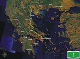
Greek National Road 1
Encyclopedia
Greece
Greece , officially the Hellenic Republic , and historically Hellas or the Republic of Greece in English, is a country in southeastern Europe....
, connecting the country's capital Athens
Athens
Athens , is the capital and largest city of Greece. Athens dominates the Attica region and is one of the world's oldest cities, as its recorded history spans around 3,400 years. Classical Athens was a powerful city-state...
with the regions of Thessaly
Thessaly
Thessaly is a traditional geographical region and an administrative region of Greece, comprising most of the ancient region of the same name. Before the Greek Dark Ages, Thessaly was known as Aeolia, and appears thus in Homer's Odyssey....
and Macedonia
Macedonia (Greece)
Macedonia is a geographical and historical region of Greece in Southern Europe. Macedonia is the largest and second most populous Greek region...
, as well as the country's second largest city, Thessaloniki
Thessaloniki
Thessaloniki , historically also known as Thessalonica, Salonika or Salonica, is the second-largest city in Greece and the capital of the region of Central Macedonia as well as the capital of the Decentralized Administration of Macedonia and Thrace...
.
The motorway begins at Kifissou Avenue, Athens, just north of the Bay of Phaliro
Phaleron Bay
Faliron Bay, is a bay almost 8 km directly SW of Athens overlooking Andreas Syngrou Avenue...
, and continues northward to Evzoni
Evzoni
Evzoni is a town in Kilkis Prefecture in Central Macedonia, Greece. The main border crossing between Greece and the Republic of Macedonia is located here. The Macedonian town opposite Evzoni is Bogorodica, in Gevgelija municipality....
, on the border with the country's northern neighbour, the Republic of Macedonia
Republic of Macedonia
Macedonia , officially the Republic of Macedonia , is a country located in the central Balkan peninsula in Southeast Europe. It is one of the successor states of the former Yugoslavia, from which it declared independence in 1991...
, where it continues as the M1. Before the European routes numbers were changed, the northern part from Efzoni to EO2
Greek National Road 2
The National Road 2 in Greece is a single carriageway with at-grade intersections in the regions of Macedonia and Thrace. It is often confused with the A2 Egnatia Odos, which is a motorway/freeway and is similarly numbered as .Parts of the road belong to european route E86....
was E5N while today, the entire road is part of European route E75
European route E75
European route E 75 is part of the International E-road network, which is a series of main roads in Europe.The E 75 starts from Vardø, Norway in the Barents Sea and runs south through Finland, Poland, Czech Republic, Slovakia, Hungary, Serbia and Republic of Macedonia to Sitia, Greece on...
. The task of maintaining and charging for parts of the motorway has recently been ceded to private consortiums, originally as part of the deal for the construction of the Ionia Odos
Ionia Odos
The Ionia Odos , sometimes called Ionian Highway in English, is a motorway, currently under construction, running through the western part of Greece. The total length will be 196 km from Rio to Ioannina. It is part of the E55 on its full length, along with the non-motorway part of Kakavia -...
. Each of them currently enforces a different tolling policy. From Athens to Maliakos Bay drivers pay twice northbound and once southbound, while on the part from northern Maliakos bay up to the intersection with A2
Egnatia Odos (modern road)
Egnatia Odos is the Greek part of the European route. It is a motorway in Greece that extends from the western port of Igoumenitsa to the eastern Greek–Turkish border at Kipoi. It runs a total of...
/E90
European route E90
European route E 90 is an A-Class West-East European route, extending from Lisbon in Portugal in the west to the Turkish-Iraqi border in the east.-Itinerary:...
in northern Greece (that part is named Aegean Motorway), drivers pay four times on both directions.
The part west of downtown Athens runs over the Cephisus
Cephissus (Athenian plain)
Cephissus , Kifissós) or Cephisus Kifisos), a river flowing through the Athenian plain.In his summary of Greek mythology Apollodorus declares that Erechtheus' wife Praxithea was daughter of Phrasimus by Diogenia daughter of Cephissus.This river is found in the western part of the...
river and Kifissou Avenue. From north of the boundary of Voiotia - Phthiotis
Phthiotis
Phthiotis is one of the regional units of Greece. It is part of the administrative region of Central Greece. The capital is the city of Lamia. It is bordered by the Malian Gulf to the east, Boeotia in the south, Phocis in the south, Aetolia-Acarnania in the southwest, Evrytania in the west,...
, up to near Velestino, the tollway runs close to the coast of the Aegean Sea
Aegean Sea
The Aegean Sea[p] is an elongated embayment of the Mediterranean Sea located between the southern Balkan and Anatolian peninsulas, i.e., between the mainlands of Greece and Turkey. In the north, it is connected to the Marmara Sea and Black Sea by the Dardanelles and Bosporus...
. It then continues north of the Tempe
Vale of Tempe
The Vale of Tempe is a gorge in northern Thessaly, Greece, located between Olympus to the north and Ossa to the south. The valley is 10 kilometers long and as narrow as 25 meters in places, with cliffs nearly 500 meters high, and through it flows the Pineios River on its way to the Aegean Sea...
Valley and up to the junction of the European route E90
European route E90
European route E 90 is an A-Class West-East European route, extending from Lisbon in Portugal in the west to the Turkish-Iraqi border in the east.-Itinerary:...
. It then shares a 25 km common part with A2
Egnatia Odos
Egnatia Odos may refer to:* The Via Egnatia, an ancient Roman road in the southern Balkans* Egnatia Odos , Greek National Road 2, partly following the same route as the Via Egnatia*Egnatia Street, Thessaloniki, a street in Thessaloniki...
/ E90 (on a west-east direction), and then, at the "Axios Interchange", continues north to Evzoni
Evzoni
Evzoni is a town in Kilkis Prefecture in Central Macedonia, Greece. The main border crossing between Greece and the Republic of Macedonia is located here. The Macedonian town opposite Evzoni is Bogorodica, in Gevgelija municipality....
and the national border. Its total length is approximately 550 km.
History
The motorway used to be entirely a 2-lane highway and ended near KateriniKaterini
Katerini is a town in Central Macedonia, Greece, the capital of Pieria regional unit. It lies on the Pierian plain, between Mt. Olympus and the Thermaikos Gulf, at an altitude of 14 m. The town, which is one of the newest in Greece, has a population of 83,764...
until 1973. The section Athens - Lamia
Lamia (city)
Lamia is a city in central Greece. The city has a continuous history since antiquity, and is today the capital of the regional unit of Phthiotis and of the Central Greece region .-Name:...
opened in August 1962 as a 14 m width road. The section Lamia
Lamia (city)
Lamia is a city in central Greece. The city has a continuous history since antiquity, and is today the capital of the regional unit of Phthiotis and of the Central Greece region .-Name:...
- Larissa
Larissa
Larissa is the capital and biggest city of the Thessaly region of Greece and capital of the Larissa regional unit. It is a principal agricultural centre and a national transportation hub, linked by road and rail with the port of Volos, the city of Thessaloniki and Athens...
opened in October 1967 as a 14 m width road. The section Larissa
Larissa
Larissa is the capital and biggest city of the Thessaly region of Greece and capital of the Larissa regional unit. It is a principal agricultural centre and a national transportation hub, linked by road and rail with the port of Volos, the city of Thessaloniki and Athens...
- Katerini
Katerini
Katerini is a town in Central Macedonia, Greece, the capital of Pieria regional unit. It lies on the Pierian plain, between Mt. Olympus and the Thermaikos Gulf, at an altitude of 14 m. The town, which is one of the newest in Greece, has a population of 83,764...
opened in September 1959 as a 13 m width road (except the Tempe
Vale of Tempe
The Vale of Tempe is a gorge in northern Thessaly, Greece, located between Olympus to the north and Ossa to the south. The valley is 10 kilometers long and as narrow as 25 meters in places, with cliffs nearly 500 meters high, and through it flows the Pineios River on its way to the Aegean Sea...
valley pass opened as 10 m road). The section Katerini
Katerini
Katerini is a town in Central Macedonia, Greece, the capital of Pieria regional unit. It lies on the Pierian plain, between Mt. Olympus and the Thermaikos Gulf, at an altitude of 14 m. The town, which is one of the newest in Greece, has a population of 83,764...
- Thessaloniki
Thessaloniki
Thessaloniki , historically also known as Thessalonica, Salonika or Salonica, is the second-largest city in Greece and the capital of the region of Central Macedonia as well as the capital of the Decentralized Administration of Macedonia and Thrace...
opened in September 1973 as a 14 m width road. The section Axios
Axios, Thessaloniki
Axios was a former municipality in the Thessaloniki regional unit, Greece. Since the 2011 local government reform, the town is part of the municipality Delta, of which it is a municipal unit. It is named after the river Axios. Population 6,780 . The seat of the municipality was in Kymina....
junction - Evzoni
Evzoni
Evzoni is a town in Kilkis Prefecture in Central Macedonia, Greece. The main border crossing between Greece and the Republic of Macedonia is located here. The Macedonian town opposite Evzoni is Bogorodica, in Gevgelija municipality....
(border) opened in July 1973. The section Axios
Axios, Thessaloniki
Axios was a former municipality in the Thessaloniki regional unit, Greece. Since the 2011 local government reform, the town is part of the municipality Delta, of which it is a municipal unit. It is named after the river Axios. Population 6,780 . The seat of the municipality was in Kymina....
junction - Polykastro
Polykastro
Polykastro , is a town and a former municipality in Kilkis regional unit, Greece. Since the 2011 local government reform it is part of the municipality Paionia, of which it is a municipal unit, and the seat. The municipal unit of Polykastro has 12,000 inhabitants, and includes Polykastro and 23...
opened as a 14 m width road, while the section Polykastro
Polykastro
Polykastro , is a town and a former municipality in Kilkis regional unit, Greece. Since the 2011 local government reform it is part of the municipality Paionia, of which it is a municipal unit, and the seat. The municipal unit of Polykastro has 12,000 inhabitants, and includes Polykastro and 23...
- Evzoni
Evzoni
Evzoni is a town in Kilkis Prefecture in Central Macedonia, Greece. The main border crossing between Greece and the Republic of Macedonia is located here. The Macedonian town opposite Evzoni is Bogorodica, in Gevgelija municipality....
(border) opened as a motorway.
When it was extended to Thessaloniki and to the border with the Republic of Macedonia, the motorway had 4-lanes. It was extended during construction in the north in the 1980s and the south in the early and mid 1990s which began near the Afidnes toll. In 1995, Motorway 1 had motorway characteristics in the sections Athens
Athens
Athens , is the capital and largest city of Greece. Athens dominates the Attica region and is one of the world's oldest cities, as its recorded history spans around 3,400 years. Classical Athens was a powerful city-state...
- Thebes
Thebes, Greece
Thebes is a city in Greece, situated to the north of the Cithaeron range, which divides Boeotia from Attica, and on the southern edge of the Boeotian plain. It played an important role in Greek myth, as the site of the stories of Cadmus, Oedipus, Dionysus and others...
and Kleidi - Thessaloniki
Thessaloniki
Thessaloniki , historically also known as Thessalonica, Salonika or Salonica, is the second-largest city in Greece and the capital of the region of Central Macedonia as well as the capital of the Decentralized Administration of Macedonia and Thrace...
, while the section Thebes - Kleidi was an undivided 14 m road. In 1998, the motorway had 6-lanes up to north of Thebes, and 4 lanes from Thebes up to the Tempe Valley with a few sections at western Magnesia
Magnesia Prefecture
Magnesia Prefecture was one of the prefectures of Greece. Its capital was Volos. It was established in 1899 from the Larissa Prefecture. The prefecture was disbanded on 1 January 2011 by the Kallikratis programme, and split into the peripheral units of Magnesia and the Sporades.The toponym is...
still having 2 lanes. Since then, the Larissa
Larissa
Larissa is the capital and biggest city of the Thessaly region of Greece and capital of the Larissa regional unit. It is a principal agricultural centre and a national transportation hub, linked by road and rail with the port of Volos, the city of Thessaloniki and Athens...
bypass has been constructed. As of 2005 it complies with all motorway standards for most of its length, except for 78 km around the Maliakos Bay and 25 km through the Tempe
Vale of Tempe
The Vale of Tempe is a gorge in northern Thessaly, Greece, located between Olympus to the north and Ossa to the south. The valley is 10 kilometers long and as narrow as 25 meters in places, with cliffs nearly 500 meters high, and through it flows the Pineios River on its way to the Aegean Sea...
Valley, further to the north. Plans are underway to upgrade to motorway status at these parts with bypasses at the Maliakos Gulf part, and new tunnels at the Tempe Valley part. Construction of the Maliakos part is almost complete, with only the Lamia
Lamia (city)
Lamia is a city in central Greece. The city has a continuous history since antiquity, and is today the capital of the regional unit of Phthiotis and of the Central Greece region .-Name:...
and Stylida
Stylida
Stylida is a town and a municipality in Phthiotis, Greece. The population of the municipal unit was 6,858 .-Municipality:The municipality Stylida was formed at the 2011 local government reform by the merger of the following 3 former municipalities, that became municipal...
bypasses still unfinished. The tunnels at Tempe will be complete by 2012.
The new circular road round Athens now means that traffic can continue to the Peloponnese
Peloponnese
The Peloponnese, Peloponnesos or Peloponnesus , is a large peninsula , located in a region of southern Greece, forming the part of the country south of the Gulf of Corinth...
, linking up with the motoway under construction to the port city of Patras
Patras
Patras , ) is Greece's third largest urban area and the regional capital of West Greece, located in northern Peloponnese, 215 kilometers west of Athens...
and that of Kalamata
Kalamata
Kalamata is the second-largest city of the Peloponnese in southern Greece. The capital and chief port of the Messenia prefecture, it lies along the Nedon River at the head of the Messenian Gulf...
.
Interchanges
The toll motorway passes through towns and cities, which are ordered from south to north below. The exits are still unnumbered even though they are posted in some cases:- Posidonos Avenue: the motorway starts at an interchange with this avenue, close to Pireus
- Attiki OdosAttiki OdosAttiki Odos is a privately owned toll motorway in Greece. The Proastiakos high-speed suburban rail is set almost entirely in the median of the motorway, along its main section. The motorway's numbers are 6 for the main section, 64 for the Hymettus Beltway and 65 for the Aigaleo Beltway...
(8th km) - interchange - Tatoiou Street - interchange - 12th km
- Interchange with Lykovryssi and Athens' Sewage Plant - 14th km
- Interchange with the old Olympic Village- 15th km
- Interchange with Kifissia (from northbound) - formerly an intersection - 16th km
- Ekali-Varybobi (Nea Eritrea) (17th km) - interchange
- west of Agios Stefanos (21st km)
- Varybobi - Agios Stefanos interchange (25th km)
- near AfidnesAfidnesAfidnes is a suburb in Attica, Greece just about 28 km north of Athens. Since the 2011 local government reform it is part of the municipality Oropos, of which it is a municipal unit....
and the Aphidnes toll booth/station and to Varybobi (northern part) (28th km) - Interchange to Kalamos
- Interchange to MalakasaMalakasaMalakasa is a town and former community of Attica in Greece, it is also a suburb of Athens. Since the 2011 local government reform it is part of the municipality Oropos, of which it is a municipal unit....
and Skala OropouSkala OropouSkala Oropou is a community in East Attica, Greece, on the South Gulf of Euboea, due north of Athens. Since the 2011 local government reform it is part of the municipality Oropos, of which it is a community....
as well as Avlona (rarelt Greek National Road 79Greek National Road 79Greek National Road 79 is a national highway of Greece. It connects Malakasa with Oropos....
) - Interchange to OinofytaOinofytaOinofyta is a village and former municipality in eastern Boeotia, Greece. Following the local government reform of 2011 it is now part of the municipality of Tanagra, of which it is a municipal unit...
and Dilessi - Schimatari Tolls
- Schimatari Interchange - access to EuboeaEuboeaEuboea is the second largest Greek island in area and population, after Crete. The narrow Euripus Strait separates it from Boeotia in mainland Greece. In general outline it is a long and narrow, seahorse-shaped island; it is about long, and varies in breadth from to...
and TanagraTanagraTanagra is a town and a municipality north of Athens in Boeotia, Greece. The seat of the municipality is the town Schimatari. It is not far from Thebes, and it was noted in antiquity for the figurines named after it...
(GR-44Greek National Road 44Greek National Road 44 is a highway linking the cities of Thiva, Chalkida and Karystos. The total length is nearly 200 km. The highway passes in the prefectures of Viotia and Euboea. Much of the highway has curvy roads....
) - Eleon Interchange - access to west of Chalkida and to EuboeaEuboeaEuboea is the second largest Greek island in area and population, after Crete. The narrow Euripus Strait separates it from Boeotia in mainland Greece. In general outline it is a long and narrow, seahorse-shaped island; it is about long, and varies in breadth from to...
- Thiva Interchange - north and east of Thiva/Thebes (GR-3Greek National Road 3Greek National Road 3 begins from Eleusis and heads north, passing Larissa, Florina and terminates at the border with the Republic of Macedonia in Niki, which from there links with the M3. The road is part of the E65. In the late 1980s, motorway bypasses have been constructed for the towns...
) - Kastro Interchange
- Martino Interchange, access to AtalantiAtalantiAtalanti is a town and a former municipality in southeastern Phthiotis, Greece. Since the 2011 local government reform it is part of the municipality Lokroi, of which it is the seat and a municipal unit. Atalanti is a known market town, and it was the capital of the former Locris Province....
- MalesinaMalesinaMalesina is a town and a former municipality in Phthiotis, Greece. Since 2011 the local government reform, it became a part of the new municipality Lokroi, of which it is a municipal unit. Malesina is located in the former Locris Province, in south-east Phthiotis. It is at the 125th kilometer of...
Interchange - Tragana Interchange
- Skala Interchange
- LivanatesLivanatesLivanates is a seaside town in Phthiotis, central Greece. It is located 68km southeast of Lamia and it was the seat of the municipality of Dafnousia.-History:...
Interchange - Arkitsa Interchange
- Agios Konstantinos Interchange
- Regkinio Interchange
- Construction zone - westward
- Future junction with an unplanned tunnel
- Kamena VourlaKamena VourlaKamena Vourla is a town and a former municipality in Phthiotis, Greece. Since the 2011 local government reform it is part of the municipality Molos-Agios Konstantinos, of which it is the seat and a municipal unit. Population 5,064 . It is crossed by the main highway connecting Athens and...
Interchange - Skarfeia Interchange
- Molos Interchange
- MendenitsaMendenitsaMendenitsa , in the Middle Ages known as Bodonitsa or Vodonitsa , is a village on Mt. Kallidromon in Phthiotis, Greece. It is part of the municipality of Molos.During the late Middle Ages, it was the seat of the Marquisate of Bodonitsa...
Interchange - AmfissaAmfissaAmfissa is a town and a former municipality in Phocis, Greece. Since the 2011 local government reform it is part of the municipality Delphi, of which it is the seat and a municipal unit. It is also the capital of the regional unit of Phocis...
Interchange (GR-27Greek National Road 27Greek National Road 27 is a highway linking Itea, Amfissa and Lamia. The south to north highway is divided into two sections, the Itea and Amfissa Highway and the Amfissa - Lamia Highway. It is now the only highway linking Patras and the western Peloponnese and Central, Northcentral and Northern...
) - LamiaLamia (city)Lamia is a city in central Greece. The city has a continuous history since antiquity, and is today the capital of the regional unit of Phthiotis and of the Central Greece region .-Name:...
(208th km) - (GR-3Greek National Road 3Greek National Road 3 begins from Eleusis and heads north, passing Larissa, Florina and terminates at the border with the Republic of Macedonia in Niki, which from there links with the M3. The road is part of the E65. In the late 1980s, motorway bypasses have been constructed for the towns...
) - old national road - Lamia North (213rd/214th km) - (GR-28Greek National Road 38Greek National Road 38 is a highway linking the cities of Agrinio, Karpenisi and Lamia. It is the only highway linking Agrinio and Larissa because GR-30 is narrow. The highway passes into the reservoir of the Acheloos river and into the Pindus ranges. It later passes through Karpenisi and into...
(Agrinio - Karpenisi Lamia Road) - StylidaStylidaStylida is a town and a municipality in Phthiotis, Greece. The population of the municipal unit was 6,858 .-Municipality:The municipality Stylida was formed at the 2011 local government reform by the merger of the following 3 former municipalities, that became municipal...
Interchange - Raches Interchange
- Pelasgia's Toll
- Agioi Theodoroi Interchange
- AlmyrosAlmyrosAlmyros is a town and a municipality of the peripheral unit of Magnesia, periphery of Thessaly, Greece. It lies in the center of prosperous fertile plain known as 'Krokio Pedio', which is crossed by torrents, and produces wheat, tobacco, and other crops. Almyros is an important agricultural and...
-Efxinoupoli Interchange - Krokio Interchange
- Mikrothives Interchange (GR-30Greek National Road 30The Greek National Road 30 is a highway or route that links the cities of Volos, Karditsa, Trikala and Arta.-Information:...
) - Velestino/VolosVolosVolos is a coastal port city in Thessaly situated midway on the Greek mainland, about 326 km north of Athens and 215 km south of Thessaloniki...
(first constructed as two separate interchanges) - (GR-6Greek National Road 6Greek National Road 6 is a highway in north-central Greece. It begins at the port of Igoumenitsa and ends at Larissa. Part of the new road is run under the name Egnatia Odos from Igoumenitsa to east of the tunnel at Metsovo. It has junctions of GR-19GR-5/20/E55, GR-15, GR-30 and finally at...
, GR 30 and GR-34) - RizomylosRizomylosRizomylos or Rizomilos may refer to several places in Greece:*Rizomylos, a village in the Achaea prefecture*Rizomylos a village in the Messenia prefecture*Rizomylos a village in the Magnesia prefecture...
Interchange - Myra Interchange
- Nikaia/LarissaLarissaLarissa is the capital and biggest city of the Thessaly region of Greece and capital of the Larissa regional unit. It is a principal agricultural centre and a national transportation hub, linked by road and rail with the port of Volos, the city of Thessaloniki and Athens...
South - with the old National Road and [to GR-3 and GR-6 - Melissochori/Larissa East (GR-6Greek National Road 6Greek National Road 6 is a highway in north-central Greece. It begins at the port of Igoumenitsa and ends at Larissa. Part of the new road is run under the name Egnatia Odos from Igoumenitsa to east of the tunnel at Metsovo. It has junctions of GR-19GR-5/20/E55, GR-15, GR-30 and finally at...
(Larissa - Trikala Road) - Akro/Larissa North Interchange - with the old National road and to GR-3 of the Larissa north By-Pass (Elassona, Tirnavos and Kozani)
- EvangelismosEvangelismosEvangelismos may refer to:*"Evangelismos" General Hospital, a hospital in Athens*Evangelismos station, a metro station in AthensAlso Evangelismos may refer to the following places in Greece:...
- former road junctions
- Tempe Toll
- the TempeVale of TempeThe Vale of Tempe is a gorge in northern Thessaly, Greece, located between Olympus to the north and Ossa to the south. The valley is 10 kilometers long and as narrow as 25 meters in places, with cliffs nearly 500 meters high, and through it flows the Pineios River on its way to the Aegean Sea...
Valley (2-lanes) - Platamonas Interchange
- SkotinaSkotinaSkotina is a town with 957 inhabitants , of the former municipality of East Olympos, which is part of the municipality of Dio-Olympos, in the Pieria regional unit, Central Macedonia, Greece...
Interchange - Leptokarya Toll
- LeptokaryaLeptokaryaLeptokarya is a town in Pieria prefecture, Central Macedonia, Greece, former capital of East Olympos municipality, which is part of the municipality of Dio-Olympos. The distance from Katerini is 26 km and it has 4.225 inhabitants, according 2001 cencus. Lies on the coast of Aegean Sea, under the...
Interchange - LitochoroLitochoroLitochoro is a town and a former municipality in the southern part of the Pieria regional unit, Greece. Since the 2011 local government reform it is part of the municipality Dio-Olympos, of which it is the seat and a municipal unit. It is located at the base of Mount Olympus, on the western shore...
Interchange - Dion Interchange
- Nea EfesosNea EfesosNea Efesos is a big settlement of the former Municipality of Dio, which is part of the municipality of Dio-Olympos, in the Pieria regional unit, Central Macedonia, Greece....
Interchange - KateriniKateriniKaterini is a town in Central Macedonia, Greece, the capital of Pieria regional unit. It lies on the Pierian plain, between Mt. Olympus and the Thermaikos Gulf, at an altitude of 14 m. The town, which is one of the newest in Greece, has a population of 83,764...
Centre Interchange (GR-13Greek National Road 13Greek National Road 13 is a highway that links Katerini with the GR-3 at Mikro Eleftherohori . Traffic usually has between low and moderate use including its highways in the Greek islands.-Places:...
(Katerini - Elassona Road) - Katerini-Paralia
- east of KateriniKateriniKaterini is a town in Central Macedonia, Greece, the capital of Pieria regional unit. It lies on the Pierian plain, between Mt. Olympus and the Thermaikos Gulf, at an altitude of 14 m. The town, which is one of the newest in Greece, has a population of 83,764...
- KorinosKorinosKorino is a town and a former municipality in Pieria regional unit, Greece. Since the 2011 local government reform it is part of the municipality Katerini, of which it is a municipal unit. Korinos has approximately 5000 citizens and it's located 5 km northeast of the city of Katerini , the...
Interchange - Makrygialos Interchange, serves to Sfendami and PydnaPydnaPydna was a Greek city in ancient Macedon, the most important in Pieria. Modern Pydna is a small town and a former municipality in the northeastern part of Pieria regional unit, Greece. Since the 2011 local government reform it is part of the municipality Pydna-Kolindros, of which it is a...
- Methoni Interchanges, also serves to Nea Agathoupoli
- AiginioAiginioAiginio is a town and a former municipality in Pieria regional unit, Greece. Since the 2011 local government reform it is part of the municipality Pydna-Kolindros, of which it is the seat and a municipal unit. Population 5,264 .-External links:**...
Interchange - Aliakmon River
- Kleidi Junction, junction of E90European route E90European route E 90 is an A-Class West-East European route, extending from Lisbon in Portugal in the west to the Turkish-Iraqi border in the east.-Itinerary:...
/GR-4, the via EgnatiaEgnatia Odos (modern road)Egnatia Odos is the Greek part of the European route. It is a motorway in Greece that extends from the western port of Igoumenitsa to the eastern Greek–Turkish border at Kipoi. It runs a total of...
(west) - junction of E90 to ThessalonikiThessalonikiThessaloniki , historically also known as Thessalonica, Salonika or Salonica, is the second-largest city in Greece and the capital of the region of Central Macedonia as well as the capital of the Decentralized Administration of Macedonia and Thrace...
- Loudias River, Imathia - ThessalonikiThessaloniki PrefectureThessaloniki is one of the regional units of Greece. It is part of the Region of Central Macedonia. Its capital is the city of Thessaloniki. It is the second most populous regional unit in Greece, behind Central Athens.-Geography:...
prefectural boundary - Nea Malgara Interchange
- Nea Malgara Tolls
- Axios River
- AxiosAxios, ThessalonikiAxios was a former municipality in the Thessaloniki regional unit, Greece. Since the 2011 local government reform, the town is part of the municipality Delta, of which it is a municipal unit. It is named after the river Axios. Population 6,780 . The seat of the municipality was in Kymina....
Junction - junction of Via Egnatia to Thessaloniki and the bypass - ChalastraChalastraChalastra is a town and was a former municipality in the Thessaloniki regional unit, Greece. Since the 2011 local government reform it is part of the municipality Delta, of which it is a municipal unit. The town is located 20 km west from the city of Thessaloniki, on the north side of Greek...
Interchange - Gefyra Junction - junction with GR-2Greek National Road 2The National Road 2 in Greece is a single carriageway with at-grade intersections in the regions of Macedonia and Thrace. It is often confused with the A2 Egnatia Odos, which is a motorway/freeway and is similarly numbered as .Parts of the road belong to european route E86....
(Edessa - Thessaloniki Road) - VathylakosVathylakosVathylakkos may refer to several places in Greece:*Vathylakkos, Drama, a town in the municipality of Drama*Vathylakkos, Karditsa, a town in the Menelaida municipal unit*Vathylakkos, Kozani, a town in the Kozani peripheral unit...
Interchange - Prochoma Interchange
- Polykastro-KilkisKilkisKilkis is an industrial city in Central Macedonia, Greece. As of 2001 there were 17,430 people living in the city proper, 24,812 people living in the municipal unit, and 56,336 in the municipality of Kilkis. It is also the capital city of the regional unit of Kilkis.-Name:Kilkis is located in a...
Interchange - EvzoniEvzoniEvzoni is a town in Kilkis Prefecture in Central Macedonia, Greece. The main border crossing between Greece and the Republic of Macedonia is located here. The Macedonian town opposite Evzoni is Bogorodica, in Gevgelija municipality....
Interchange, near Evzoni - International border with the Republic of Macedonia (access with M1)