
Geography of Turkey
Encyclopedia
Turkey
is situated in Anatolia
and the Balkans, bordering the Black Sea
, between Bulgaria
and Georgia
, and bordering the Aegean Sea
and the Mediterranean Sea
, between Greece
and Syria
. The geographic coordinates of the country lie at: 39°00′N 35°00′E
The area of Turkey is 783562 km² (302,535 sq mi); land: 770760 km² (297,592 sq mi), water: 9820 km² (3,792 sq mi).
Turkey extends more than 1600 km (994 mi) from west to east but generally less than 800 km (497 mi) from north to south. Total land area is about 783562 km² (302,535 sq mi), of which 756816 km² (292,208 sq mi) are in Asia and 23764 km² (9,175 sq mi) in Europe (Thrace
).
Anatolia is a large, roughly rectangular peninsula situated bridge like between Europe and Asia. The Anatolian part of Turkey accounts for 97% of the country's area. It is also known as Asia Minor, Asiatic Turkey or the Anatolian Plateau. The term Anatolia is most frequently used in specific reference to the large, semiarid central plateau, which is rimmed by hills and mountains that in many places limit access to the fertile, densely settled coastal regions.
The European portion of Turkey, known as Thrace
, encompasses 3% of the total area but is home to more than 10% of the total population. Istanbul
, the largest city of Europe and Turkey, has a population of 11,372,613. Thrace is separated from the Asian portion of Turkey by the Bosporus
, the Sea of Marmara
, and the Dardanelles
.
206 km (128 mi), Bulgaria
240 km (149 mi), Georgia
252 km (157 mi), Armenia
268 km (167 mi), Nakhchivan (Azerbaijan
) 9 km (6 mi), Iran
499 km (310 mi), Iraq
331 km (206 mi), Syria
822 km (511 mi).
Coastline: 7200 km (4,474 mi) Maritime claims: exclusive economic zone: in Black Sea only: to the maritime boundary
agreed upon with the former USSR territorial sea: 6 nmi (11.1 km; 6.9 mi) in the Aegean Sea; 12 nmi (22.2 km; 13.8 mi) in Black Sea and in Mediterranean Sea
Surrounded by water on three sides and protected by high mountains along its eastern border, the country generally has well-defined natural borders. Its demarcated land frontiers were settled by treaty early in the twentieth century and have since remained stable.
The boundary with Greece
was confirmed by the Treaty of Lausanne
in 1923, which resolved persistent boundary and territorial claims involving areas in Thrace and provided for a population exchange (see: War of Independence
). Under the agreement, most members of the sizable Greek-speaking community of western Turkey were forced to resettle in Greece, while the majority of the Turkish-speaking residents of Thrace
who were not forced out during the Balkan wars
were removed to Turkey.
The boundary with Bulgaria
was confirmed by the Treaty of Lausanne
in 1923.
Since 1991 the more than 500 km (311 mi) boundary with the former Soviet Union
, which was defined in the 1921 Treaty of Moscow (1921)
and Treaty of Kars
, has formed Turkey's borders with the independent countries of Armenia
, Azerbaijan
, and Georgia
. Despite Armenia's loss of territory as a result of the treaty, Armenia, as a legal successor to the Armenian SSR
, declared its loyalty to the Treaty of Kars and all agreements inherited by the former Soviet Armenian government after its independence.
The boundary with Iran
was confirmed by the Kasr-i Sirin treaty in 1638.
The boundary with Iraq
was confirmed by the Treaty of Angora (Ankara
) in 1926. Turkey's two southern neighbors, Iraq and Syria
, had been part of the Ottoman Empire
up to 1918. According to the terms of the Treaty of Lausanne
, Turkey ceded all its claims to these two countries, which had been organized as League of Nations
mandates under the governing responsibility of Britain
and France
, respectively. Turkey and Britain agreed the boundary in the Treaty of Angora (Ankara).
Turkey's boundary with Syria has not been accepted by Syria
. As a result of the Treaty of Lausanne
, the former Ottoman Sanjak (province) of Alexandretta (present-day Hatay Province
) was ceded to Syria. However, in June 1939 the people of Hatay had formed a new independent State and immediately after, the parliament voted to unite with Turkey. Since achieving independence in 1946, Syria has harbored a lingering resentment over the loss of the province and its principal towns of Antakya
and İskenderun
(formerly Antioch and Alexandretta). This issue has continued to be an irritant in Syrian-Turkish relations.
 Turkey's varied landscapes are the product of a wide variety of tectonic processes that have shaped Anatolia over millions of years and continue today as evidenced by frequent earthquakes and occasional volcanic eruptions. Except for a relatively small portion of its territory along the Syrian border that is a continuation of the Arabian Platform, Turkey geologically is part of the great Alpine belt that extends from the Atlantic Ocean
to the Himalaya Mountains. This belt was formed during the Tertiary Period (about 65 million to 1.6 million B.C.), as the Arabian, African, and Indian continental plates
began to collide with the Eurasian plate
. This process is still at work today as the African Plate converges with the Eurasian Plate and the Anatolian Plate escapes towards the west and southwest along strike-slip faults. These are the North Anatolian Fault
Zone, which forms the present day plate boundary of Eurasia near the Black Sea coast, and the East Anatolian Fault
Zone, which forms part of the boundary of the North Arabian Plate in the southeast. As a result, Turkey lies on one of the world's seismically
most active regions.
However, many of the rocks exposed in Turkey were formed long before this process began. Turkey contains outcrops of Precambrian rocks, (more than 540 million years old; Bozkurt et al., 2000). The earliest geological history of Turkey is poorly understood, partly because of the problem of reconstructing how the region has been tectonically assembled by plate motions. Turkey can be thought of as a collage of different pieces (possibly terrane
s) of ancient continental and oceanic lithosphere
stuck together by younger igneous, volcanic and sedimentary rocks.)
During the Mesozoic
era (about 250 to 65 million years ago) a large ocean (Tethys Ocean
), floored by oceanic lithosphere
existed in-between the supercontinents of Gondwana
and Laurasia
(which lay to the south and north respectively; Robertson & Dixon, 2006). This large oceanic plate was consumed at subduction zones (see subduction zone). At the subduction trenches the sedimentary rock
layers that were deposited within the prehistoric Tethys Ocean
buckled, were folded, faulted and tectonically mixed with huge blocks of crystalline basement rocks of the oceanic lithosphere
. These blocks form a very complex mixture or mélange
of rocks that include mainly serpentinite
, basalt
, dolerite and chert
(e.g. Bergougnan, 1975). The Eurasian margin, now preserved in the Pontides (the Pontic Mountains
along the Black Sea
coast), is thought to have been geologically similar to the Western Pacific region today (e.g. Rice et al., 2006). Volcanic arcs (see volcanic arc
) and backarc basins (see back-arc basin
) formed and were emplaced onto Eurasia
as ophiolites (see ophiolite) as they collided with microcontinents (literally relatively small plates of continental lithosphere
; e.g. Ustaomer and Robertson, 1997). These microcontinents had been pulled away from the Gondwanan continent further south. Turkey is therefore made up from several different prehistorical microcontinents.
During the Cenozoic
(Tertiary
about 65 to 1.6 million years) folding, faulting and uplifting, accompanied by volcanic activity and intrusion of igneous rocks was related to major continental collision between the larger Arabian and Eurasian plates (e.g. Robertson & Dixon, 1984).
Present-day earthquakes range from barely perceptible tremors to major movements measuring five or higher on the open-ended Richter scale
. Turkey's most severe earthquake in the twentieth century occurred in Erzincan
on the night of December 28–29, 1939; it devastated most of the city and caused an estimated 160,000 deaths. Earthquakes of moderate intensity often continue with sporadic aftershocks over periods of several days or even weeks. The most earthquake-prone part of Turkey is an arc-shaped region stretching from the general vicinity of Kocaeli
to the area north of Lake Van
on the border with Armenia
and Georgia
.
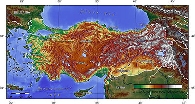
 Turkey's terrain is structurally complex. A central massif composed of uplifted blocks and downfolded troughs, covered by recent deposits and giving the appearance of a plateau with rough terrain, is wedged between two folded mountain ranges that converge in the east. True lowland is confined to the Ergene Plain in Thrace
, extending along rivers that discharge into the Aegean Sea
or the Sea of Marmara
, and to a few narrow coastal strips along the Black Sea
and Mediterranean Sea
coasts.
Nearly 85% of the land is at an elevation of at least 450 meters; the average and median altitude of the country is 1,332 and 1,128 meters, respectively. In Asiatic Turkey, flat or gently sloping land is rare and largely confined to the deltas of the Kızıl River, the coastal plains of Antalya and Adana, and the valley floors of the Gediz River and the Büyükmenderes River
, and some interior high plains in Anatolia, mainly around Tuz Gölü
(Salt Lake) and Konya Ovasi (Konya Basin). Moderately sloping terrain is limited almost entirely outside Thrace to the hills of the Arabian Platform along the border with Syria.
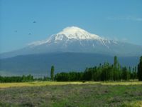
More than 80% of the land surface is rough, broken, and mountainous, and therefore is of limited agricultural value (see Agriculture, ch. 3). The terrain's ruggedness is accentuated in the eastern part of the country, where the two mountain ranges converge into a lofty region with a median elevation of more than 1,500 meters, which reaches its highest point along the borders with Armenia, Azerbaijan, and Iran. Turkey's highest peak, Mount Ararat
(Ağrı Dağı) — 5,137 meters high — is situated near the point where the boundaries of the four countries meet.
 According to worldofturkey.com
Distinct contrasts between the interior and periphery of Turkey are manifested in its landform regions, climate, soils, and vegetation. The periphery is divided into the Black Sea region, the Marmara region, the Aegean region, and the Mediterranean region. The interior is divided into three regions: Central Anatolia, Eastern Anatolia and Southeastern Anatolia.
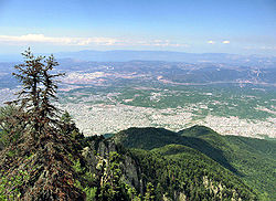
 The Black Sea region has a steep, rocky coast with rivers that cascade through the gorges of the coastal ranges. A few larger rivers, those cutting back through the Pontic Mountains
(Doğu Karadeniz Dağları), have tributaries that flow in broad, elevated basins. Access inland from the coast is limited to a few narrow valleys because mountain ridges, with elevations of 1,525 to 1,800 meters in the west and 3,000 to 4,000 meters in the east in Kaçkar Mountains
, form an almost unbroken wall separating the coast from the interior. The higher slopes facing northwest tend to be densely forested. Because of these natural conditions, the Black Sea coast historically has been isolated from Anatolia.
Running from Zonguldak
in the west to Rize
in the east, the narrow coastal strip widens at several places into fertile, intensely cultivated deltas. The Samsun
area, close to the midpoint, is a major tobacco-growing region; east of it are numerous citrus groves. East of Samsun, the area around Trabzon
is world-renowned for the production of hazelnuts, and farther east the Rize region has numerous tea plantations. All cultivable areas, including mountain slopes wherever they are not too steep, are sown or used as pasture. The mild, damp climate of the Black Sea coast makes commercial farming profitable. The western part of the Black Sea region, especially the Zonguldak area, is a center of coal mining and heavy industry.
The North Anatolian Mountains in the north are an interrupted chain of folded highlands that generally parallel the Black Sea coast. In the west, the mountains tend to be low, with elevations rarely exceeding 1,500 meters, but they rise in an easterly direction to heights greater than 3,000 meters south of Rize. Lengthy, troughlike valleys and basins characterize the mountains. Rivers flow from the mountains toward the Black Sea. The southern slopes—facing the Anatolian Plateau—are mostly unwooded, but the northern slopes contain dense growths of both deciduous and evergreen trees.
 The European portion of Turkey consists mainly of rolling plateau country well suited to agriculture. It receives about 520 millimeters of rainfall annually.
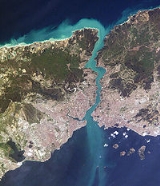
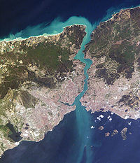
Densely populated, this area includes the cities of Istanbul
and Edirne
. The Bosphorus, which links the Sea of Marmara
and the Black Sea, is about twenty-five kilometers long and averages 1.5 kilometers in width but narrows in places to less than 1000 meters. There are two suspension bridges over the Bosphorus, both its Asian and European banks rise steeply from the water and form a succession of cliffs, coves, and nearly landlocked bays. Most of the shores are densely wooded and are marked by numerous small towns and villages. The Dardanelles
Strait, which links the Sea of Marmara and the Aegean Sea, is approximately forty kilometers long and increases in width toward the south. Unlike the Bosphorus, the Dardanelles has fewer settlements along its shores. The Saros Bay
is located near the Gallipoli
peninsula and is famous for its clean beaches. It is a favourite spot among scuba divers for the richness of its underwater fauna
and is becoming increasingly popular due to its vicinity to Istanbul.
The most important valleys are the Kocaeli
Valley, the Bursa
Ovasi (Bursa Basin), and the Plains of Troy
(historically known as the Troad.) The valley lowlands around Bursa is densely populated.
 Located on the western side of Anatolia, the Aegean region has a fertile soil and a typically Mediterranean climate; with mild, wet winters and hot, dry summers. The broad, cultivated valley lowlands contain about half of the country's richest farmlands.
The largest city in the Aegean Region of Turkey is İzmir
, which is also the country's third largest city and a major manufacturing center; as well as its second largest port after Istanbul.
Olive
and olive oil
production is particularly important for the economy of the region. The seaside town of Ayvalık
and numerous towns in the provinces of Balıkesir
, İzmir
and Aydın
are particularly famous for their olive oil and related products; such as soap and cosmetics.
The region also has many important centers of tourism which are known both for their historic monuments and for the beauty of their beaches; such as Assos
, Ayvalık
, Bergama
, Foça
, İzmir
, Çeşme
, Sardis
, Ephesus
, Kuşadası
, Didim
, Miletus
, Bodrum
, Marmaris
, Datça
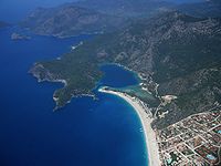
and Fethiye
.
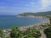 Toward the east, the extensive plains around Adana
(Cicillian plains or ), Turkey's fifth most populous city, consist largely of reclaimed flood lands. In general, rivers have not cut valleys to the sea in the western part of the region. Historically, movement inland from the western Mediterranean coast was difficult. East of Adana, much of the coastal plain has limestone features such as collapsed caverns and sinkholes. Between Adana and Antalya
, the Taurus Mountains
rise sharply from the coast to high elevations. Other than Adana, Antalya, and Mersin
, the Mediterranean coast has few major cities, although it has numerous farming villages.
Paralleling the Mediterranean coast, the Taurus Mountains
are Turkey's second chain of folded mountains. The range rises just inland from the coast and trends generally in an easterly direction until it reaches the Arabian Platform, where it arcs around the northern side of the platform. The Taurus Mountains are more rugged and less dissected by rivers than the Pontus Mountains and historically have served as a barrier to human movement inland from the Mediterranean coast except where there are mountain passes such as the historic Cilician Gates
(Gülek Pass), northwest of Adana.
 Stretching inland from the Aegean coastal plain, the Central Anatolian occupies the area between the two zones of the folded mountains, extending east to the point where the two ranges converge. The plateau-like, semiarid highlands of Anatolia
are considered the heartland of the country. The region varies in elevation from 600 to 1,200 meters from west to east. The two largest basins on the plateau are the Konya
Ovasi and the basin occupied by the large salt lake, Tuz Gölü
. Both basins are characterized by inland drainage. Wooded areas are confined to the northwest and northeast of the plateau. Rain-fed cultivation is widespread, with wheat being the principal crop. Irrigated agriculture is restricted to the areas surrounding rivers and wherever sufficient underground water is available. Important irrigated crops include barley, corn, cotton, various fruits, grapes, opium poppies, sugar beets, roses, and tobacco. There also is extensive grazing throughout the plateau.
Central Anatolia receives little annual rainfall. For instance, the semiarid center of the plateau receives an average yearly precipitation of only 300 millimeters. However, actual rainfall from year to year is irregular and occasionally may be less than 200 millimeters, leading to severe reductions in crop yields for both rain-fed and irrigated agriculture. In years of low rainfall, stock losses also can be high. Overgrazing has contributed to soil erosion on the plateau. During the summers, frequent dust storms blow a fine yellow powder across the plateau. Locusts occasionally ravage the eastern area in April and May. In general, the plateau experiences extreme heat, with almost no rainfall in summer and cold weather with heavy snow in winter.
Frequently interspersed throughout the folded mountains, and also situated on the Anatolian Plateau, are well-defined basins, which the Turks call ova . Some are no more than a widening of a stream valley; others, such as the Konya Ovasi, are large basins of inland drainage or are the result of limestone erosion. Most of the basins take their names from cities or towns located at their rims. Where a lake has formed within the basin, the water body is usually saline as a result of the internal drainage—the water has no outlet to the sea.
 Eastern Anatolia, where the Pontus and Taurus mountain ranges converge, is rugged country with higher elevations, a more severe climate, and greater precipitation than are found on the Anatolian Plateau. The region is known as the Anti-Taurus, and the average elevation of its peaks exceeds 3,000 meters. Mount Ararat
, at 5,137 meters the highest point in Turkey, is located in the Anti-Taurus. Many of the Anti-Taurus peaks apparently are recently extinct volcanoes, to judge from extensive lava flows. Turkey's largest lake, Lake Van
, is situated in the mountains at an elevation of 1,546 meters. The headwaters of three major rivers arise in the Anti-Taurus: the east-flowing Aras, which pours into the Caspian Sea
; the south-flowing Euphrates
; and the south-flowing Tigris
, which eventually joins the Euphrates in Iraq
before emptying into the Persian Gulf
. Several small streams that empty into the Black Sea or landlocked Lake Van also originate in these mountains.
In addition to its rugged mountains, the area is known for severe winters with heavy snowfalls. The few valleys and plains in these mountains tend to be fertile and to support diverse agriculture. The main basin is the Mus Valley, west of Lake Van. Narrow valleys also lie at the foot of the lofty peaks along river corridors.
Southeast Anatolia is south of the Anti-Taurus Mountains. It is a region of rolling hills and a broad plateau surface that extends into Syria. Elevations decrease gradually, from about 800 meters in the north to about 500 meters in the south. Traditionally, wheat and barley
were the main crops of the region, but the inauguration of major new irrigation projects in the 1980s has led to greater agricultural diversity and development.
Mountains close to the coast prevent Mediterranean influences from extending inland, giving the interior of Turkey a continental climate with distinct seasons. The Anatolian Plateau is much more subject to extremes than are the coastal areas. Winters on the plateau are especially severe. Temperatures of -30 C can occur in the mountainous areas in the east, and snow may lie on the ground 120 days of the year. In the west, winter temperatures average below 1 °C (33.8 °F). Summers are hot and dry, with temperatures above 30 °C (86 °F). Annual precipitation averages about 400 millimetres (15.7 in) , with actual amounts determined by elevation. The driest regions are the Konya Ovasi and the Malatya Ovasi, where annual rainfall frequently is less than 300 millimetres (11.8 in). May is generally the wettest month and July and August the driest.
The climate of the Anti-Taurus Mountain region of eastern Turkey can be inhospitable. Summers tend to be hot and extremely dry. Winters are bitterly cold with frequent, heavy snowfall. Villages can be isolated for several days during winter storms. Spring and autumn are generally mild, but during both seasons sudden hot and cold spells frequently occur.
arable land:
32%
permanent crops:
4%
permanent pastures:
16%
forests and woodland:
26%
other:
22% (1993 est.)
Irrigated land:
36,740 km² (1993 est.)
Elevation extremes:
lowest point:
Mediterranean Sea 0 m
highest point:
Mount Ararat
5,137 m
struck northwestern Turkey, killing more than 17,000 and injuring 44,000.
, Antarctic Treaty, Biodiversity
, Desertification
, Endangered Species
, Hazardous Wastes, Nuclear Test Ban, Ozone Layer Protection, Ship Pollution
, Wetlands
signed, but not ratified:
Antarctic-Environmental Protocol, Environmental Modification
, Sea of Marmara
, Dardanelles
) that link Black
and Aegean Sea
s.
Turkey
Turkey , known officially as the Republic of Turkey , is a Eurasian country located in Western Asia and in East Thrace in Southeastern Europe...
is situated in Anatolia
Anatolia
Anatolia is a geographic and historical term denoting the westernmost protrusion of Asia, comprising the majority of the Republic of Turkey...
and the Balkans, bordering the Black Sea
Black Sea
The Black Sea is bounded by Europe, Anatolia and the Caucasus and is ultimately connected to the Atlantic Ocean via the Mediterranean and the Aegean seas and various straits. The Bosphorus strait connects it to the Sea of Marmara, and the strait of the Dardanelles connects that sea to the Aegean...
, between Bulgaria
Bulgaria
Bulgaria , officially the Republic of Bulgaria , is a parliamentary democracy within a unitary constitutional republic in Southeast Europe. The country borders Romania to the north, Serbia and Macedonia to the west, Greece and Turkey to the south, as well as the Black Sea to the east...
and Georgia
Georgia (country)
Georgia is a sovereign state in the Caucasus region of Eurasia. Located at the crossroads of Western Asia and Eastern Europe, it is bounded to the west by the Black Sea, to the north by Russia, to the southwest by Turkey, to the south by Armenia, and to the southeast by Azerbaijan. The capital of...
, and bordering the Aegean Sea
Aegean Sea
The Aegean Sea[p] is an elongated embayment of the Mediterranean Sea located between the southern Balkan and Anatolian peninsulas, i.e., between the mainlands of Greece and Turkey. In the north, it is connected to the Marmara Sea and Black Sea by the Dardanelles and Bosporus...
and the Mediterranean Sea
Mediterranean Sea
The Mediterranean Sea is a sea connected to the Atlantic Ocean surrounded by the Mediterranean region and almost completely enclosed by land: on the north by Anatolia and Europe, on the south by North Africa, and on the east by the Levant...
, between Greece
Greece
Greece , officially the Hellenic Republic , and historically Hellas or the Republic of Greece in English, is a country in southeastern Europe....
and Syria
Syria
Syria , officially the Syrian Arab Republic , is a country in Western Asia, bordering Lebanon and the Mediterranean Sea to the West, Turkey to the north, Iraq to the east, Jordan to the south, and Israel to the southwest....
. The geographic coordinates of the country lie at: 39°00′N 35°00′E
The area of Turkey is 783562 km² (302,535 sq mi); land: 770760 km² (297,592 sq mi), water: 9820 km² (3,792 sq mi).
Turkey extends more than 1600 km (994 mi) from west to east but generally less than 800 km (497 mi) from north to south. Total land area is about 783562 km² (302,535 sq mi), of which 756816 km² (292,208 sq mi) are in Asia and 23764 km² (9,175 sq mi) in Europe (Thrace
Thrace
Thrace is a historical and geographic area in southeast Europe. As a geographical concept, Thrace designates a region bounded by the Balkan Mountains on the north, Rhodope Mountains and the Aegean Sea on the south, and by the Black Sea and the Sea of Marmara on the east...
).
Anatolia is a large, roughly rectangular peninsula situated bridge like between Europe and Asia. The Anatolian part of Turkey accounts for 97% of the country's area. It is also known as Asia Minor, Asiatic Turkey or the Anatolian Plateau. The term Anatolia is most frequently used in specific reference to the large, semiarid central plateau, which is rimmed by hills and mountains that in many places limit access to the fertile, densely settled coastal regions.
The European portion of Turkey, known as Thrace
East Thrace
East Thrace or Eastern Thrace , also known as Turkish Thrace, is the part of the modern republic of Turkey that is geographically part of Europe, all in the eastern part of the historical region of Thrace; most of Turkey is in Anatolia, also known as Asia Minor. Turkish Thrace is also called...
, encompasses 3% of the total area but is home to more than 10% of the total population. Istanbul
Istanbul
Istanbul , historically known as Byzantium and Constantinople , is the largest city of Turkey. Istanbul metropolitan province had 13.26 million people living in it as of December, 2010, which is 18% of Turkey's population and the 3rd largest metropolitan area in Europe after London and...
, the largest city of Europe and Turkey, has a population of 11,372,613. Thrace is separated from the Asian portion of Turkey by the Bosporus
Bosporus
The Bosphorus or Bosporus , also known as the Istanbul Strait , is a strait that forms part of the boundary between Europe and Asia. It is one of the Turkish Straits, along with the Dardanelles...
, the Sea of Marmara
Sea of Marmara
The Sea of Marmara , also known as the Sea of Marmora or the Marmara Sea, and in the context of classical antiquity as the Propontis , is the inland sea that connects the Black Sea to the Aegean Sea, thus separating Turkey's Asian and European parts. The Bosphorus strait connects it to the Black...
, and the Dardanelles
Dardanelles
The Dardanelles , formerly known as the Hellespont, is a narrow strait in northwestern Turkey connecting the Aegean Sea to the Sea of Marmara. It is one of the Turkish Straits, along with its counterpart the Bosphorus. It is located at approximately...
.
External boundaries
Land boundaries: 2627 km (1,632 mi) border countries: GreeceGreece
Greece , officially the Hellenic Republic , and historically Hellas or the Republic of Greece in English, is a country in southeastern Europe....
206 km (128 mi), Bulgaria
Bulgaria
Bulgaria , officially the Republic of Bulgaria , is a parliamentary democracy within a unitary constitutional republic in Southeast Europe. The country borders Romania to the north, Serbia and Macedonia to the west, Greece and Turkey to the south, as well as the Black Sea to the east...
240 km (149 mi), Georgia
Georgia (country)
Georgia is a sovereign state in the Caucasus region of Eurasia. Located at the crossroads of Western Asia and Eastern Europe, it is bounded to the west by the Black Sea, to the north by Russia, to the southwest by Turkey, to the south by Armenia, and to the southeast by Azerbaijan. The capital of...
252 km (157 mi), Armenia
Armenia
Armenia , officially the Republic of Armenia , is a landlocked mountainous country in the Caucasus region of Eurasia...
268 km (167 mi), Nakhchivan (Azerbaijan
Azerbaijan
Azerbaijan , officially the Republic of Azerbaijan is the largest country in the Caucasus region of Eurasia. Located at the crossroads of Western Asia and Eastern Europe, it is bounded by the Caspian Sea to the east, Russia to the north, Georgia to the northwest, Armenia to the west, and Iran to...
) 9 km (6 mi), Iran
Iran
Iran , officially the Islamic Republic of Iran , is a country in Southern and Western Asia. The name "Iran" has been in use natively since the Sassanian era and came into use internationally in 1935, before which the country was known to the Western world as Persia...
499 km (310 mi), Iraq
Iraq
Iraq ; officially the Republic of Iraq is a country in Western Asia spanning most of the northwestern end of the Zagros mountain range, the eastern part of the Syrian Desert and the northern part of the Arabian Desert....
331 km (206 mi), Syria
Syria
Syria , officially the Syrian Arab Republic , is a country in Western Asia, bordering Lebanon and the Mediterranean Sea to the West, Turkey to the north, Iraq to the east, Jordan to the south, and Israel to the southwest....
822 km (511 mi).
Coastline: 7200 km (4,474 mi) Maritime claims: exclusive economic zone: in Black Sea only: to the maritime boundary
Maritime boundary
Maritime boundary is a conceptual means of division of the water surface of the planet into maritime areas that are defined through surrounding physical geography or by human geography. As such it usually includes areas of exclusive national rights over the mineral and biological resources,...
agreed upon with the former USSR territorial sea: 6 nmi (11.1 km; 6.9 mi) in the Aegean Sea; 12 nmi (22.2 km; 13.8 mi) in Black Sea and in Mediterranean Sea
Surrounded by water on three sides and protected by high mountains along its eastern border, the country generally has well-defined natural borders. Its demarcated land frontiers were settled by treaty early in the twentieth century and have since remained stable.
The boundary with Greece
Greece
Greece , officially the Hellenic Republic , and historically Hellas or the Republic of Greece in English, is a country in southeastern Europe....
was confirmed by the Treaty of Lausanne
Treaty of Lausanne
The Treaty of Lausanne was a peace treaty signed in Lausanne, Switzerland on 24 July 1923, that settled the Anatolian and East Thracian parts of the partitioning of the Ottoman Empire. The treaty of Lausanne was ratified by the Greek government on 11 February 1924, by the Turkish government on 31...
in 1923, which resolved persistent boundary and territorial claims involving areas in Thrace and provided for a population exchange (see: War of Independence
Turkish War of Independence
The Turkish War of Independence was a war of independence waged by Turkish nationalists against the Allies, after the country was partitioned by the Allies following the Ottoman Empire's defeat in World War I...
). Under the agreement, most members of the sizable Greek-speaking community of western Turkey were forced to resettle in Greece, while the majority of the Turkish-speaking residents of Thrace
Thrace
Thrace is a historical and geographic area in southeast Europe. As a geographical concept, Thrace designates a region bounded by the Balkan Mountains on the north, Rhodope Mountains and the Aegean Sea on the south, and by the Black Sea and the Sea of Marmara on the east...
who were not forced out during the Balkan wars
Balkan Wars
The Balkan Wars were two conflicts that took place in the Balkans in south-eastern Europe in 1912 and 1913.By the early 20th century, Montenegro, Bulgaria, Greece and Serbia, the countries of the Balkan League, had achieved their independence from the Ottoman Empire, but large parts of their ethnic...
were removed to Turkey.
The boundary with Bulgaria
Bulgaria
Bulgaria , officially the Republic of Bulgaria , is a parliamentary democracy within a unitary constitutional republic in Southeast Europe. The country borders Romania to the north, Serbia and Macedonia to the west, Greece and Turkey to the south, as well as the Black Sea to the east...
was confirmed by the Treaty of Lausanne
Treaty of Lausanne
The Treaty of Lausanne was a peace treaty signed in Lausanne, Switzerland on 24 July 1923, that settled the Anatolian and East Thracian parts of the partitioning of the Ottoman Empire. The treaty of Lausanne was ratified by the Greek government on 11 February 1924, by the Turkish government on 31...
in 1923.
Since 1991 the more than 500 km (311 mi) boundary with the former Soviet Union
Soviet Union
The Soviet Union , officially the Union of Soviet Socialist Republics , was a constitutionally socialist state that existed in Eurasia between 1922 and 1991....
, which was defined in the 1921 Treaty of Moscow (1921)
Treaty of Moscow (1921)
The Treaty of Moscow or Treaty of Brotherhood was a friendship treaty between the Grand National Assembly of Turkey under the leadership of Mustafa Kemal Atatürk and Bolshevist Russia under the leadership of Vladimir Lenin, signed on 16 March 1921...
and Treaty of Kars
Treaty of Kars
The Treaty of Kars was a "friendship" treaty signed in Kars on October 13, 1921 and ratified in Yerevan on September 11 1922.Signatories included representatives from the Grand National Assembly of Turkey, which in 1923 would declare the Republic of Turkey, and also from Soviet Armenia, Soviet...
, has formed Turkey's borders with the independent countries of Armenia
Armenia
Armenia , officially the Republic of Armenia , is a landlocked mountainous country in the Caucasus region of Eurasia...
, Azerbaijan
Azerbaijan
Azerbaijan , officially the Republic of Azerbaijan is the largest country in the Caucasus region of Eurasia. Located at the crossroads of Western Asia and Eastern Europe, it is bounded by the Caspian Sea to the east, Russia to the north, Georgia to the northwest, Armenia to the west, and Iran to...
, and Georgia
Georgia (country)
Georgia is a sovereign state in the Caucasus region of Eurasia. Located at the crossroads of Western Asia and Eastern Europe, it is bounded to the west by the Black Sea, to the north by Russia, to the southwest by Turkey, to the south by Armenia, and to the southeast by Azerbaijan. The capital of...
. Despite Armenia's loss of territory as a result of the treaty, Armenia, as a legal successor to the Armenian SSR
Armenian SSR
The Armenian Soviet Socialist Republic The Armenian Soviet Socialist Republic The Armenian Soviet Socialist Republic The Armenian Soviet Socialist Republic The Armenian Soviet Socialist Republic The Armenian Soviet Socialist Republic The Armenian Soviet Socialist Republic The Armenian Soviet...
, declared its loyalty to the Treaty of Kars and all agreements inherited by the former Soviet Armenian government after its independence.
The boundary with Iran
Iran
Iran , officially the Islamic Republic of Iran , is a country in Southern and Western Asia. The name "Iran" has been in use natively since the Sassanian era and came into use internationally in 1935, before which the country was known to the Western world as Persia...
was confirmed by the Kasr-i Sirin treaty in 1638.
The boundary with Iraq
Iraq
Iraq ; officially the Republic of Iraq is a country in Western Asia spanning most of the northwestern end of the Zagros mountain range, the eastern part of the Syrian Desert and the northern part of the Arabian Desert....
was confirmed by the Treaty of Angora (Ankara
Ankara
Ankara is the capital of Turkey and the country's second largest city after Istanbul. The city has a mean elevation of , and as of 2010 the metropolitan area in the entire Ankara Province had a population of 4.4 million....
) in 1926. Turkey's two southern neighbors, Iraq and Syria
Syria
Syria , officially the Syrian Arab Republic , is a country in Western Asia, bordering Lebanon and the Mediterranean Sea to the West, Turkey to the north, Iraq to the east, Jordan to the south, and Israel to the southwest....
, had been part of the Ottoman Empire
Ottoman Empire
The Ottoman EmpireIt was usually referred to as the "Ottoman Empire", the "Turkish Empire", the "Ottoman Caliphate" or more commonly "Turkey" by its contemporaries...
up to 1918. According to the terms of the Treaty of Lausanne
Treaty of Lausanne
The Treaty of Lausanne was a peace treaty signed in Lausanne, Switzerland on 24 July 1923, that settled the Anatolian and East Thracian parts of the partitioning of the Ottoman Empire. The treaty of Lausanne was ratified by the Greek government on 11 February 1924, by the Turkish government on 31...
, Turkey ceded all its claims to these two countries, which had been organized as League of Nations
League of Nations
The League of Nations was an intergovernmental organization founded as a result of the Paris Peace Conference that ended the First World War. It was the first permanent international organization whose principal mission was to maintain world peace...
mandates under the governing responsibility of Britain
United Kingdom of Great Britain and Ireland
The United Kingdom of Great Britain and Ireland was the formal name of the United Kingdom during the period when what is now the Republic of Ireland formed a part of it....
and France
France
The French Republic , The French Republic , The French Republic , (commonly known as France , is a unitary semi-presidential republic in Western Europe with several overseas territories and islands located on other continents and in the Indian, Pacific, and Atlantic oceans. Metropolitan France...
, respectively. Turkey and Britain agreed the boundary in the Treaty of Angora (Ankara).
Turkey's boundary with Syria has not been accepted by Syria
Syria
Syria , officially the Syrian Arab Republic , is a country in Western Asia, bordering Lebanon and the Mediterranean Sea to the West, Turkey to the north, Iraq to the east, Jordan to the south, and Israel to the southwest....
. As a result of the Treaty of Lausanne
Treaty of Lausanne
The Treaty of Lausanne was a peace treaty signed in Lausanne, Switzerland on 24 July 1923, that settled the Anatolian and East Thracian parts of the partitioning of the Ottoman Empire. The treaty of Lausanne was ratified by the Greek government on 11 February 1924, by the Turkish government on 31...
, the former Ottoman Sanjak (province) of Alexandretta (present-day Hatay Province
Hatay Province
Hatay Province is a province in southern Turkey, on the Mediterranean coast. It is bordered by Syria to the south and east and the Turkish provinces of Adana and Osmaniye to the north. The province is part of Çukurova, a geographical, economical and cultural region that covers the provinces of...
) was ceded to Syria. However, in June 1939 the people of Hatay had formed a new independent State and immediately after, the parliament voted to unite with Turkey. Since achieving independence in 1946, Syria has harbored a lingering resentment over the loss of the province and its principal towns of Antakya
Antakya
Antakya is the seat of the Hatay Province in southern Turkey, near the border with Syria. The mayor is Lütfü Savaş.Known as Antioch in ancient times, the city has historical significance for Christianity, as it was the place where the followers of Jesus Christ were called Christians for the first...
and İskenderun
Iskenderun
İskenderun is a city and urban district in the province of Hatay on the Mediterranean coast of Turkey. The current mayor is Yusuf Hamit Civelek .-Names:...
(formerly Antioch and Alexandretta). This issue has continued to be an irritant in Syrian-Turkish relations.
Geology
Atlantic Ocean
The Atlantic Ocean is the second-largest of the world's oceanic divisions. With a total area of about , it covers approximately 20% of the Earth's surface and about 26% of its water surface area...
to the Himalaya Mountains. This belt was formed during the Tertiary Period (about 65 million to 1.6 million B.C.), as the Arabian, African, and Indian continental plates
Tectonic Plates
Tectonic Plates is a 1992 independent Canadian film directed by Peter Mettler. Mettler also wrote the screenplay based on the play by Robert Lepage. The film stars Marie Gignac, Céline Bonnier and Robert Lepage.-Plot summary:...
began to collide with the Eurasian plate
Eurasian Plate
The Eurasian Plate is a tectonic plate which includes most of the continent of Eurasia , with the notable exceptions of the Indian subcontinent, the Arabian subcontinent, and the area east of the Chersky Range in East Siberia...
. This process is still at work today as the African Plate converges with the Eurasian Plate and the Anatolian Plate escapes towards the west and southwest along strike-slip faults. These are the North Anatolian Fault
North Anatolian Fault
The North Anatolian Fault is a major active right lateral-moving strike-slip fault in northern Anatolia which runs along the transform boundary between the Eurasian Plate and the Anatolian Plate. The fault extends westward from a junction with the East Anatolian Fault at the Karliova Triple...
Zone, which forms the present day plate boundary of Eurasia near the Black Sea coast, and the East Anatolian Fault
East Anatolian Fault
The East Anatolian Fault is a major strike-slip fault zone in eastern Turkey. It forms the transform type tectonic boundary between the Anatolian Plate and the northward-moving Arabian Plate. The difference in the relative motions of the two plates is manifest in the left lateral motion along the...
Zone, which forms part of the boundary of the North Arabian Plate in the southeast. As a result, Turkey lies on one of the world's seismically
Seismology
Seismology is the scientific study of earthquakes and the propagation of elastic waves through the Earth or through other planet-like bodies. The field also includes studies of earthquake effects, such as tsunamis as well as diverse seismic sources such as volcanic, tectonic, oceanic,...
most active regions.
However, many of the rocks exposed in Turkey were formed long before this process began. Turkey contains outcrops of Precambrian rocks, (more than 540 million years old; Bozkurt et al., 2000). The earliest geological history of Turkey is poorly understood, partly because of the problem of reconstructing how the region has been tectonically assembled by plate motions. Turkey can be thought of as a collage of different pieces (possibly terrane
Terrane
A terrane in geology is short-hand term for a tectonostratigraphic terrane, which is a fragment of crustal material formed on, or broken off from, one tectonic plate and accreted or "sutured" to crust lying on another plate...
s) of ancient continental and oceanic lithosphere
Lithosphere
The lithosphere is the rigid outermost shell of a rocky planet. On Earth, it comprises the crust and the portion of the upper mantle that behaves elastically on time scales of thousands of years or greater.- Earth's lithosphere :...
stuck together by younger igneous, volcanic and sedimentary rocks.)
During the Mesozoic
Mesozoic
The Mesozoic era is an interval of geological time from about 250 million years ago to about 65 million years ago. It is often referred to as the age of reptiles because reptiles, namely dinosaurs, were the dominant terrestrial and marine vertebrates of the time...
era (about 250 to 65 million years ago) a large ocean (Tethys Ocean
Tethys Ocean
The Tethys Ocean was an ocean that existed between the continents of Gondwana and Laurasia during the Mesozoic era before the opening of the Indian Ocean.-Modern theory:...
), floored by oceanic lithosphere
Lithosphere
The lithosphere is the rigid outermost shell of a rocky planet. On Earth, it comprises the crust and the portion of the upper mantle that behaves elastically on time scales of thousands of years or greater.- Earth's lithosphere :...
existed in-between the supercontinents of Gondwana
Gondwana
In paleogeography, Gondwana , originally Gondwanaland, was the southernmost of two supercontinents that later became parts of the Pangaea supercontinent. It existed from approximately 510 to 180 million years ago . Gondwana is believed to have sutured between ca. 570 and 510 Mya,...
and Laurasia
Laurasia
In paleogeography, Laurasia was the northernmost of two supercontinents that formed part of the Pangaea supercontinent from approximately...
(which lay to the south and north respectively; Robertson & Dixon, 2006). This large oceanic plate was consumed at subduction zones (see subduction zone). At the subduction trenches the sedimentary rock
Sedimentary rock
Sedimentary rock are types of rock that are formed by the deposition of material at the Earth's surface and within bodies of water. Sedimentation is the collective name for processes that cause mineral and/or organic particles to settle and accumulate or minerals to precipitate from a solution....
layers that were deposited within the prehistoric Tethys Ocean
Tethys Ocean
The Tethys Ocean was an ocean that existed between the continents of Gondwana and Laurasia during the Mesozoic era before the opening of the Indian Ocean.-Modern theory:...
buckled, were folded, faulted and tectonically mixed with huge blocks of crystalline basement rocks of the oceanic lithosphere
Lithosphere
The lithosphere is the rigid outermost shell of a rocky planet. On Earth, it comprises the crust and the portion of the upper mantle that behaves elastically on time scales of thousands of years or greater.- Earth's lithosphere :...
. These blocks form a very complex mixture or mélange
Mélange
In geology, a mélange is a large-scale breccia, a mappable body of rock characterized by a lack of continuous bedding and the inclusion of fragments of rock of all sizes, contained in a fine-grained deformed matrix. The mélange typically consists of a jumble of large blocks of varied lithologies...
of rocks that include mainly serpentinite
Serpentinite
Serpentinite is a rock composed of one or more serpentine group minerals. Minerals in this group are formed by serpentinization, a hydration and metamorphic transformation of ultramafic rock from the Earth's mantle...
, basalt
Basalt
Basalt is a common extrusive volcanic rock. It is usually grey to black and fine-grained due to rapid cooling of lava at the surface of a planet. It may be porphyritic containing larger crystals in a fine matrix, or vesicular, or frothy scoria. Unweathered basalt is black or grey...
, dolerite and chert
Chert
Chert is a fine-grained silica-rich microcrystalline, cryptocrystalline or microfibrous sedimentary rock that may contain small fossils. It varies greatly in color , but most often manifests as gray, brown, grayish brown and light green to rusty red; its color is an expression of trace elements...
(e.g. Bergougnan, 1975). The Eurasian margin, now preserved in the Pontides (the Pontic Mountains
Pontic Mountains
The Pontic Mountains form a mountain range in Northern Turkey, also known as the Parhar mountains in the local Turkish and Pontic Greek languages. The term "Parhar" originates from the Hittite word meaning "high" or "summit"....
along the Black Sea
Black Sea
The Black Sea is bounded by Europe, Anatolia and the Caucasus and is ultimately connected to the Atlantic Ocean via the Mediterranean and the Aegean seas and various straits. The Bosphorus strait connects it to the Sea of Marmara, and the strait of the Dardanelles connects that sea to the Aegean...
coast), is thought to have been geologically similar to the Western Pacific region today (e.g. Rice et al., 2006). Volcanic arcs (see volcanic arc
Volcanic arc
A volcanic arc is a chain of volcanoes positioned in an arc shape as seen from above. Offshore volcanoes form islands, resulting in a volcanic island arc. Generally they result from the subduction of an oceanic tectonic plate under another tectonic plate, and often parallel an oceanic trench...
) and backarc basins (see back-arc basin
Back-arc basin
Back-arc basins are geologic features, submarine basins associated with island arcs and subduction zones.They are found at some convergent plate boundaries, presently concentrated in the Western Pacific ocean. Most of them result from tensional forces caused by oceanic trench rollback and the...
) formed and were emplaced onto Eurasia
Eurasia
Eurasia is a continent or supercontinent comprising the traditional continents of Europe and Asia ; covering about 52,990,000 km2 or about 10.6% of the Earth's surface located primarily in the eastern and northern hemispheres...
as ophiolites (see ophiolite) as they collided with microcontinents (literally relatively small plates of continental lithosphere
Lithosphere
The lithosphere is the rigid outermost shell of a rocky planet. On Earth, it comprises the crust and the portion of the upper mantle that behaves elastically on time scales of thousands of years or greater.- Earth's lithosphere :...
; e.g. Ustaomer and Robertson, 1997). These microcontinents had been pulled away from the Gondwanan continent further south. Turkey is therefore made up from several different prehistorical microcontinents.
During the Cenozoic
Cenozoic
The Cenozoic era is the current and most recent of the three Phanerozoic geological eras and covers the period from 65.5 mya to the present. The era began in the wake of the Cretaceous–Tertiary extinction event at the end of the Cretaceous that saw the demise of the last non-avian dinosaurs and...
(Tertiary
Tertiary
The Tertiary is a deprecated term for a geologic period 65 million to 2.6 million years ago. The Tertiary covered the time span between the superseded Secondary period and the Quaternary...
about 65 to 1.6 million years) folding, faulting and uplifting, accompanied by volcanic activity and intrusion of igneous rocks was related to major continental collision between the larger Arabian and Eurasian plates (e.g. Robertson & Dixon, 1984).
Present-day earthquakes range from barely perceptible tremors to major movements measuring five or higher on the open-ended Richter scale
Richter magnitude scale
The expression Richter magnitude scale refers to a number of ways to assign a single number to quantify the energy contained in an earthquake....
. Turkey's most severe earthquake in the twentieth century occurred in Erzincan
Erzincan
-Trivia:Erzincan has the largest man made of Portrait of Atatürk, located north of the city, 176m×43m. It covers 7,500 square meter. Turkish Army made it 1982, in 29 days by 3,000 soldier, 100 tons of black and white paint was used...
on the night of December 28–29, 1939; it devastated most of the city and caused an estimated 160,000 deaths. Earthquakes of moderate intensity often continue with sporadic aftershocks over periods of several days or even weeks. The most earthquake-prone part of Turkey is an arc-shaped region stretching from the general vicinity of Kocaeli
Izmit
İzmit is a city in Turkey, administrative center of Kocaeli Province as well as the Kocaeli Metropolitan Municipality. It is located at the Gulf of İzmit in the Sea of Marmara, about east of Istanbul, on the northwestern part of Anatolia. The city center has a population of 294.875...
to the area north of Lake Van
Lake Van
Lake Van is the largest lake in Turkey, located in the far east of the country in Van district. It is a saline and soda lake, receiving water from numerous small streams that descend from the surrounding mountains. Lake Van is one of the world's largest endorheic lakes . The original outlet from...
on the border with Armenia
Armenia
Armenia , officially the Republic of Armenia , is a landlocked mountainous country in the Caucasus region of Eurasia...
and Georgia
Georgia (country)
Georgia is a sovereign state in the Caucasus region of Eurasia. Located at the crossroads of Western Asia and Eastern Europe, it is bounded to the west by the Black Sea, to the north by Russia, to the southwest by Turkey, to the south by Armenia, and to the southeast by Azerbaijan. The capital of...
.
Thrace
Thrace is a historical and geographic area in southeast Europe. As a geographical concept, Thrace designates a region bounded by the Balkan Mountains on the north, Rhodope Mountains and the Aegean Sea on the south, and by the Black Sea and the Sea of Marmara on the east...
, extending along rivers that discharge into the Aegean Sea
Aegean Sea
The Aegean Sea[p] is an elongated embayment of the Mediterranean Sea located between the southern Balkan and Anatolian peninsulas, i.e., between the mainlands of Greece and Turkey. In the north, it is connected to the Marmara Sea and Black Sea by the Dardanelles and Bosporus...
or the Sea of Marmara
Sea of Marmara
The Sea of Marmara , also known as the Sea of Marmora or the Marmara Sea, and in the context of classical antiquity as the Propontis , is the inland sea that connects the Black Sea to the Aegean Sea, thus separating Turkey's Asian and European parts. The Bosphorus strait connects it to the Black...
, and to a few narrow coastal strips along the Black Sea
Black Sea
The Black Sea is bounded by Europe, Anatolia and the Caucasus and is ultimately connected to the Atlantic Ocean via the Mediterranean and the Aegean seas and various straits. The Bosphorus strait connects it to the Sea of Marmara, and the strait of the Dardanelles connects that sea to the Aegean...
and Mediterranean Sea
Mediterranean Sea
The Mediterranean Sea is a sea connected to the Atlantic Ocean surrounded by the Mediterranean region and almost completely enclosed by land: on the north by Anatolia and Europe, on the south by North Africa, and on the east by the Levant...
coasts.
Nearly 85% of the land is at an elevation of at least 450 meters; the average and median altitude of the country is 1,332 and 1,128 meters, respectively. In Asiatic Turkey, flat or gently sloping land is rare and largely confined to the deltas of the Kızıl River, the coastal plains of Antalya and Adana, and the valley floors of the Gediz River and the Büyükmenderes River
Maeander River
The Büyük Menderes River ; , Ancient Greek: Μαίανδρος, Maíandros) is a river in southwestern Turkey. It rises in west central Turkey near Dinar before flowing west through the Büyük Menderes graben until reaching the Aegean Sea in the proximity of the ancient Ionian city Miletus...
, and some interior high plains in Anatolia, mainly around Tuz Gölü
Lake Tuz
Lake Tuz is the second largest lake in Turkey with its surface area and one of the largest hypersaline lakes in the world. It is located in the Central Anatolia Region, northeast of Konya, south-southeast of Ankara and northwest of Aksaray.-Geography:...
(Salt Lake) and Konya Ovasi (Konya Basin). Moderately sloping terrain is limited almost entirely outside Thrace to the hills of the Arabian Platform along the border with Syria.
More than 80% of the land surface is rough, broken, and mountainous, and therefore is of limited agricultural value (see Agriculture, ch. 3). The terrain's ruggedness is accentuated in the eastern part of the country, where the two mountain ranges converge into a lofty region with a median elevation of more than 1,500 meters, which reaches its highest point along the borders with Armenia, Azerbaijan, and Iran. Turkey's highest peak, Mount Ararat
Mount Ararat
Mount Ararat is a snow-capped, dormant volcanic cone in Turkey. It has two peaks: Greater Ararat and Lesser Ararat .The Ararat massif is about in diameter...
(Ağrı Dağı) — 5,137 meters high — is situated near the point where the boundaries of the four countries meet.
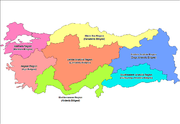
Regions
The 1st Geography Congress, held in Ankara between 6–21 June 1941, divided Turkey into seven regions after long discussions and work. These geographical regions were separated according to their climate, location, flora and fauna, human habitat, agricultural diversities, transportation, topography and so on. At the end, 4 side regions and 3 inner regions were named according to their neighborhood to the four seas surrounding Turkey and positions in Anatolia.
Distinct contrasts between the interior and periphery of Turkey are manifested in its landform regions, climate, soils, and vegetation. The periphery is divided into the Black Sea region, the Marmara region, the Aegean region, and the Mediterranean region. The interior is divided into three regions: Central Anatolia, Eastern Anatolia and Southeastern Anatolia.
Black Sea Region
Pontic Mountains
The Pontic Mountains form a mountain range in Northern Turkey, also known as the Parhar mountains in the local Turkish and Pontic Greek languages. The term "Parhar" originates from the Hittite word meaning "high" or "summit"....
(Doğu Karadeniz Dağları), have tributaries that flow in broad, elevated basins. Access inland from the coast is limited to a few narrow valleys because mountain ridges, with elevations of 1,525 to 1,800 meters in the west and 3,000 to 4,000 meters in the east in Kaçkar Mountains
Kaçkar Mountains
Kaçkar Mountains or simply Kaçkars are a mountain range that rises above the Black Sea coast in eastern Turkey.With highest peak Kaçkar Dağı at an elevation of , and mountain plateaus at about in elevation, it is the highest part of the Pontic Mountains. The Kaçkars are glaciated mountains that...
, form an almost unbroken wall separating the coast from the interior. The higher slopes facing northwest tend to be densely forested. Because of these natural conditions, the Black Sea coast historically has been isolated from Anatolia.
Running from Zonguldak
Zonguldak
Zonguldak is a city and the capital of Zonguldak Province in the Black Sea region of Turkey. Its population, according to the 2009 census, was 108,792. It is an important port on the Black Sea because of the coal mining in Zonguldak Province...
in the west to Rize
Rize
Rize is the capital of Rize Province, in northeast Turkey, on the Black Sea coast.-Etymology:The name comes from Greek or Ριζαίον , meaning "mountain slopes". In modern times, its name in Greek was usually Ριζούντα . Its Latin forms are Rhizus and Rhizaeum...
in the east, the narrow coastal strip widens at several places into fertile, intensely cultivated deltas. The Samsun
Samsun
Samsun is a city of about half a million people on the north coast of Turkey. It is the provincial capital of Samsun Province and a major Black Sea port.-Name:...
area, close to the midpoint, is a major tobacco-growing region; east of it are numerous citrus groves. East of Samsun, the area around Trabzon
Trabzon
Trabzon is a city on the Black Sea coast of north-eastern Turkey and the capital of Trabzon Province. Trabzon, located on the historical Silk Road, became a melting pot of religions, languages and culture for centuries and a trade gateway to Iran in the southeast and the Caucasus to the northeast...
is world-renowned for the production of hazelnuts, and farther east the Rize region has numerous tea plantations. All cultivable areas, including mountain slopes wherever they are not too steep, are sown or used as pasture. The mild, damp climate of the Black Sea coast makes commercial farming profitable. The western part of the Black Sea region, especially the Zonguldak area, is a center of coal mining and heavy industry.
The North Anatolian Mountains in the north are an interrupted chain of folded highlands that generally parallel the Black Sea coast. In the west, the mountains tend to be low, with elevations rarely exceeding 1,500 meters, but they rise in an easterly direction to heights greater than 3,000 meters south of Rize. Lengthy, troughlike valleys and basins characterize the mountains. Rivers flow from the mountains toward the Black Sea. The southern slopes—facing the Anatolian Plateau—are mostly unwooded, but the northern slopes contain dense growths of both deciduous and evergreen trees.
Marmara Region
Densely populated, this area includes the cities of Istanbul
Istanbul
Istanbul , historically known as Byzantium and Constantinople , is the largest city of Turkey. Istanbul metropolitan province had 13.26 million people living in it as of December, 2010, which is 18% of Turkey's population and the 3rd largest metropolitan area in Europe after London and...
and Edirne
Edirne
Edirne is a city in Eastern Thrace, the northwestern part of Turkey, close to the borders with Greece and Bulgaria. Edirne served as the capital city of the Ottoman Empire from 1365 to 1453, before Constantinople became the empire's new capital. At present, Edirne is the capital of the Edirne...
. The Bosphorus, which links the Sea of Marmara
Sea of Marmara
The Sea of Marmara , also known as the Sea of Marmora or the Marmara Sea, and in the context of classical antiquity as the Propontis , is the inland sea that connects the Black Sea to the Aegean Sea, thus separating Turkey's Asian and European parts. The Bosphorus strait connects it to the Black...
and the Black Sea, is about twenty-five kilometers long and averages 1.5 kilometers in width but narrows in places to less than 1000 meters. There are two suspension bridges over the Bosphorus, both its Asian and European banks rise steeply from the water and form a succession of cliffs, coves, and nearly landlocked bays. Most of the shores are densely wooded and are marked by numerous small towns and villages. The Dardanelles
Dardanelles
The Dardanelles , formerly known as the Hellespont, is a narrow strait in northwestern Turkey connecting the Aegean Sea to the Sea of Marmara. It is one of the Turkish Straits, along with its counterpart the Bosphorus. It is located at approximately...
Strait, which links the Sea of Marmara and the Aegean Sea, is approximately forty kilometers long and increases in width toward the south. Unlike the Bosphorus, the Dardanelles has fewer settlements along its shores. The Saros Bay
Saros Bay
Saros Bay or Gulf of Saros is an inlet of the northern Aegean Sea located north of the Gallipoli Peninsula in northwestern Turkey.The bay is 75 km long and 35 km wide. Far from industrialized areas and thanks to underwater currents, it is a popular summer recreation resort with sandy...
is located near the Gallipoli
Gallipoli
The Gallipoli peninsula is located in Turkish Thrace , the European part of Turkey, with the Aegean Sea to the west and the Dardanelles straits to the east. Gallipoli derives its name from the Greek "Καλλίπολις" , meaning "Beautiful City"...
peninsula and is famous for its clean beaches. It is a favourite spot among scuba divers for the richness of its underwater fauna
Fauna
Fauna or faunæ is all of the animal life of any particular region or time. The corresponding term for plants is flora.Zoologists and paleontologists use fauna to refer to a typical collection of animals found in a specific time or place, e.g. the "Sonoran Desert fauna" or the "Burgess shale fauna"...
and is becoming increasingly popular due to its vicinity to Istanbul.
The most important valleys are the Kocaeli
Izmit
İzmit is a city in Turkey, administrative center of Kocaeli Province as well as the Kocaeli Metropolitan Municipality. It is located at the Gulf of İzmit in the Sea of Marmara, about east of Istanbul, on the northwestern part of Anatolia. The city center has a population of 294.875...
Valley, the Bursa
Bursa Province
Bursa Province is a province in western Turkey, along the Sea of Marmara. Its adjacent provinces are Balıkesir to the west, Kütahya to the south, Bilecik and Sakarya to the east, Kocaeli to the northeast and Yalova to the north. The province has an area of 11,043 km2 and a population of 3,187,000...
Ovasi (Bursa Basin), and the Plains of Troy
Troy
Troy was a city, both factual and legendary, located in northwest Anatolia in what is now Turkey, southeast of the Dardanelles and beside Mount Ida...
(historically known as the Troad.) The valley lowlands around Bursa is densely populated.
Aegean Region
The largest city in the Aegean Region of Turkey is İzmir
Izmir
Izmir is a large metropolis in the western extremity of Anatolia. The metropolitan area in the entire Izmir Province had a population of 3.35 million as of 2010, making the city third most populous in Turkey...
, which is also the country's third largest city and a major manufacturing center; as well as its second largest port after Istanbul.
Olive
Olive
The olive , Olea europaea), is a species of a small tree in the family Oleaceae, native to the coastal areas of the eastern Mediterranean Basin as well as northern Iran at the south end of the Caspian Sea.Its fruit, also called the olive, is of major agricultural importance in the...
and olive oil
Olive oil
Olive oil is an oil obtained from the olive , a traditional tree crop of the Mediterranean Basin. It is commonly used in cooking, cosmetics, pharmaceuticals, and soaps and as a fuel for traditional oil lamps...
production is particularly important for the economy of the region. The seaside town of Ayvalık
Ayvalik
Ayvalık is a seaside town on the northwestern Aegean coast of Turkey. It is a district of the Balıkesir Province.It was alternatively called by the town's formerly indigenous Greek population, although the use of the name Ayvalık was widespread for centuries among both the Turks and the Greeks...
and numerous towns in the provinces of Balıkesir
Balikesir Province
Balıkesir Province is a province in midwestern Turkey, having coastlines on both the Sea of Marmara and the Aegean. Its adjacent provinces are Çanakkale to the west, İzmir to the southwest, Manisa to the south, Kütahya to the southeast, and Bursa to the east. The provincial capital is Balıkesir City...
, İzmir
Izmir Province
İzmir Province is a province of Turkey in western Anatolia on the Aegean coast, whose capital is the city of İzmir. On the west it is surrounded by the Aegean sea, and it encloses the Gulf of İzmir. Its area is 11,973 km.2, population 3.948.848 . The population was 3,370,866 in 2000...
and Aydın
Aydin Province
Aydın Province is a province of southwestern Turkey, located in the Aegean Region. The provincial capital is the city of Aydın which has a population of approx. 150,000 . Other towns in the province include the summer seaside resorts of Didim and Kuşadası.-History:Aydın was founded by the ancient...
are particularly famous for their olive oil and related products; such as soap and cosmetics.
The region also has many important centers of tourism which are known both for their historic monuments and for the beauty of their beaches; such as Assos
Assos
Assos , also known as Behramkale or for short Behram, is a small historically rich town in the Ayvacık district of the Çanakkale Province, Turkey....
, Ayvalık
Ayvalik
Ayvalık is a seaside town on the northwestern Aegean coast of Turkey. It is a district of the Balıkesir Province.It was alternatively called by the town's formerly indigenous Greek population, although the use of the name Ayvalık was widespread for centuries among both the Turks and the Greeks...
, Bergama
Bergama
Bergama is a populous district, as well as the center city of the same district, in İzmir Province in western Turkey. By excluding İzmir's metropolitan area, it is one of the prominent districts of the province in terms of population and is largely urbanized at the rate of 53,6 per cent...
, Foça
Foça
Foça is town and district in Turkey's İzmir Province.The town of Foça is situated at about north by northwest of İzmir city center. The district also has a township with own municipality named Yenifoça , also along the shore and at a distance of from Foça proper...
, İzmir
Izmir
Izmir is a large metropolis in the western extremity of Anatolia. The metropolitan area in the entire Izmir Province had a population of 3.35 million as of 2010, making the city third most populous in Turkey...
, Çeşme
Çesme
Çeşme is a coastal town and the center-town of the district of the same name in Turkey's western-most end, on a promontory on the tip of the peninsula which also carries the same name and which extends inland to form a whole with the wider Karaburun Peninsula...
, Sardis
Sardis
Sardis or Sardes was an ancient city at the location of modern Sart in Turkey's Manisa Province...
, Ephesus
Ephesus
Ephesus was an ancient Greek city, and later a major Roman city, on the west coast of Asia Minor, near present-day Selçuk, Izmir Province, Turkey. It was one of the twelve cities of the Ionian League during the Classical Greek era...
, Kuşadası
Kusadasi
Kuşadası is a resort town on Turkey's Aegean coast and the center of the seaside district of the same name in Aydın Province. Kuşadası lies at a distance of to the south from the region's largest metropolitan center of İzmir, and from the provincial seat of Aydın situated inland. Its primary...
, Didim
Didim
Didim, home of the antique city of Didyma with its ruined Temple of Apollo, is a small town, popular seaside holiday resort and district of Aydın Province on the Aegean coast of western Turkey, from the city of Aydın.-Geography:...
, Miletus
Miletus
Miletus was an ancient Greek city on the western coast of Anatolia , near the mouth of the Maeander River in ancient Caria...
, Bodrum
Bodrum
Bodrum is a port city in Muğla Province, in the southwestern Aegean Region of Turkey. It is located on the southern coast of Bodrum Peninsula, at a point that checks the entry into the Gulf of Gökova. The site was called Halicarnassus of Caria in ancient times and was famous for housing the...
, Marmaris
Marmaris
Marmaris is a port city and a tourist resort on the Mediterranean coast, located in southwest Turkey, in Muğla Province.Marmaris' main source of income is tourism. Little is left of the sleepy fishing village that Marmaris was just a few decades ago after a construction boom in the 1980s...
, Datça
Datça
Datça is a district of Muğla Province in south-west Turkey, and the center town of the district. The center is situated midway through the peninsula which carries the same name as the district and the town .-Geography:...
and Fethiye
Fethiye
Fethiye is a city and district of Muğla Province in the Aegean region of Turkey with about 68,000 inhabitants .-History:...
.
Mediterranean Region
Adana
Adana is a city in southern Turkey and a major agricultural and commercial center. The city is situated on the Seyhan River, 30 kilometres inland from the Mediterranean, in south-central Anatolia...
(Cicillian plains or ), Turkey's fifth most populous city, consist largely of reclaimed flood lands. In general, rivers have not cut valleys to the sea in the western part of the region. Historically, movement inland from the western Mediterranean coast was difficult. East of Adana, much of the coastal plain has limestone features such as collapsed caverns and sinkholes. Between Adana and Antalya
Antalya
Antalya is a city on the Mediterranean coast of southwestern Turkey. With a population 1,001,318 as of 2010. It is the eighth most populous city in Turkey and country's biggest international sea resort.- History :...
, the Taurus Mountains
Taurus Mountains
Taurus Mountains are a mountain complex in southern Turkey, dividing the Mediterranean coastal region of southern Turkey from the central Anatolian Plateau. The system extends along a curve from Lake Eğirdir in the west to the upper reaches of the Euphrates and Tigris rivers in the east...
rise sharply from the coast to high elevations. Other than Adana, Antalya, and Mersin
Mersin
-Mersin today:Today, Mersin is a large city spreading out along the coast, with Turkey's second tallest skyscraper , huge hotels, an opera house, expensive real estate near the sea or up in the hills, and many other modern urban...
, the Mediterranean coast has few major cities, although it has numerous farming villages.
Paralleling the Mediterranean coast, the Taurus Mountains
Taurus Mountains
Taurus Mountains are a mountain complex in southern Turkey, dividing the Mediterranean coastal region of southern Turkey from the central Anatolian Plateau. The system extends along a curve from Lake Eğirdir in the west to the upper reaches of the Euphrates and Tigris rivers in the east...
are Turkey's second chain of folded mountains. The range rises just inland from the coast and trends generally in an easterly direction until it reaches the Arabian Platform, where it arcs around the northern side of the platform. The Taurus Mountains are more rugged and less dissected by rivers than the Pontus Mountains and historically have served as a barrier to human movement inland from the Mediterranean coast except where there are mountain passes such as the historic Cilician Gates
Cilician Gates
The Cilician Gates or Gülek Pass is a pass through the Taurus Mountains connecting the low plains of Cilicia to the Anatolian Plateau, by way of the narrow gorge of the Gökoluk River. Its highest elevation is about 1000m....
(Gülek Pass), northwest of Adana.
Central Anatolia Region
Anatolia
Anatolia is a geographic and historical term denoting the westernmost protrusion of Asia, comprising the majority of the Republic of Turkey...
are considered the heartland of the country. The region varies in elevation from 600 to 1,200 meters from west to east. The two largest basins on the plateau are the Konya
Konya
Konya is a city in the Central Anatolia Region of Turkey. The metropolitan area in the entire Konya Province had a population of 1,036,027 as of 2010, making the city seventh most populous in Turkey.-Etymology:...
Ovasi and the basin occupied by the large salt lake, Tuz Gölü
Lake Tuz
Lake Tuz is the second largest lake in Turkey with its surface area and one of the largest hypersaline lakes in the world. It is located in the Central Anatolia Region, northeast of Konya, south-southeast of Ankara and northwest of Aksaray.-Geography:...
. Both basins are characterized by inland drainage. Wooded areas are confined to the northwest and northeast of the plateau. Rain-fed cultivation is widespread, with wheat being the principal crop. Irrigated agriculture is restricted to the areas surrounding rivers and wherever sufficient underground water is available. Important irrigated crops include barley, corn, cotton, various fruits, grapes, opium poppies, sugar beets, roses, and tobacco. There also is extensive grazing throughout the plateau.
Central Anatolia receives little annual rainfall. For instance, the semiarid center of the plateau receives an average yearly precipitation of only 300 millimeters. However, actual rainfall from year to year is irregular and occasionally may be less than 200 millimeters, leading to severe reductions in crop yields for both rain-fed and irrigated agriculture. In years of low rainfall, stock losses also can be high. Overgrazing has contributed to soil erosion on the plateau. During the summers, frequent dust storms blow a fine yellow powder across the plateau. Locusts occasionally ravage the eastern area in April and May. In general, the plateau experiences extreme heat, with almost no rainfall in summer and cold weather with heavy snow in winter.
Frequently interspersed throughout the folded mountains, and also situated on the Anatolian Plateau, are well-defined basins, which the Turks call ova . Some are no more than a widening of a stream valley; others, such as the Konya Ovasi, are large basins of inland drainage or are the result of limestone erosion. Most of the basins take their names from cities or towns located at their rims. Where a lake has formed within the basin, the water body is usually saline as a result of the internal drainage—the water has no outlet to the sea.
Eastern and Southeastern Anatolia Regions
Mount Ararat
Mount Ararat is a snow-capped, dormant volcanic cone in Turkey. It has two peaks: Greater Ararat and Lesser Ararat .The Ararat massif is about in diameter...
, at 5,137 meters the highest point in Turkey, is located in the Anti-Taurus. Many of the Anti-Taurus peaks apparently are recently extinct volcanoes, to judge from extensive lava flows. Turkey's largest lake, Lake Van
Lake Van
Lake Van is the largest lake in Turkey, located in the far east of the country in Van district. It is a saline and soda lake, receiving water from numerous small streams that descend from the surrounding mountains. Lake Van is one of the world's largest endorheic lakes . The original outlet from...
, is situated in the mountains at an elevation of 1,546 meters. The headwaters of three major rivers arise in the Anti-Taurus: the east-flowing Aras, which pours into the Caspian Sea
Caspian Sea
The Caspian Sea is the largest enclosed body of water on Earth by area, variously classed as the world's largest lake or a full-fledged sea. The sea has a surface area of and a volume of...
; the south-flowing Euphrates
Euphrates
The Euphrates is the longest and one of the most historically important rivers of Western Asia. Together with the Tigris, it is one of the two defining rivers of Mesopotamia...
; and the south-flowing Tigris
Tigris
The Tigris River is the eastern member of the two great rivers that define Mesopotamia, the other being the Euphrates. The river flows south from the mountains of southeastern Turkey through Iraq.-Geography:...
, which eventually joins the Euphrates in Iraq
Iraq
Iraq ; officially the Republic of Iraq is a country in Western Asia spanning most of the northwestern end of the Zagros mountain range, the eastern part of the Syrian Desert and the northern part of the Arabian Desert....
before emptying into the Persian Gulf
Persian Gulf
The Persian Gulf, in Southwest Asia, is an extension of the Indian Ocean located between Iran and the Arabian Peninsula.The Persian Gulf was the focus of the 1980–1988 Iran-Iraq War, in which each side attacked the other's oil tankers...
. Several small streams that empty into the Black Sea or landlocked Lake Van also originate in these mountains.
In addition to its rugged mountains, the area is known for severe winters with heavy snowfalls. The few valleys and plains in these mountains tend to be fertile and to support diverse agriculture. The main basin is the Mus Valley, west of Lake Van. Narrow valleys also lie at the foot of the lofty peaks along river corridors.
Southeast Anatolia is south of the Anti-Taurus Mountains. It is a region of rolling hills and a broad plateau surface that extends into Syria. Elevations decrease gradually, from about 800 meters in the north to about 500 meters in the south. Traditionally, wheat and barley
Barley
Barley is a major cereal grain, a member of the grass family. It serves as a major animal fodder, as a base malt for beer and certain distilled beverages, and as a component of various health foods...
were the main crops of the region, but the inauguration of major new irrigation projects in the 1980s has led to greater agricultural diversity and development.
Climate
Turkey's diverse regions have different climates, with the weather system on the coasts contrasting with that prevailing in the interior. The Aegean and Mediterranean coasts have cool, rainy winters and hot, moderately dry summers. Annual precipitation in those areas varies from 580 to 1300 mm (22.8 to 51.2 in), depending on location. Generally, rainfall is less to the east. The Black Sea coast receives the greatest amount of precipitation and is the only region of Turkey that receives high precipitation throughout the year. The eastern part of that coast averages 2500 millimetres (98.4 in) annually which is the highest precipitation in the country.Mountains close to the coast prevent Mediterranean influences from extending inland, giving the interior of Turkey a continental climate with distinct seasons. The Anatolian Plateau is much more subject to extremes than are the coastal areas. Winters on the plateau are especially severe. Temperatures of -30 C can occur in the mountainous areas in the east, and snow may lie on the ground 120 days of the year. In the west, winter temperatures average below 1 °C (33.8 °F). Summers are hot and dry, with temperatures above 30 °C (86 °F). Annual precipitation averages about 400 millimetres (15.7 in) , with actual amounts determined by elevation. The driest regions are the Konya Ovasi and the Malatya Ovasi, where annual rainfall frequently is less than 300 millimetres (11.8 in). May is generally the wettest month and July and August the driest.
The climate of the Anti-Taurus Mountain region of eastern Turkey can be inhospitable. Summers tend to be hot and extremely dry. Winters are bitterly cold with frequent, heavy snowfall. Villages can be isolated for several days during winter storms. Spring and autumn are generally mild, but during both seasons sudden hot and cold spells frequently occur.
| Regions | Average Temp. | Record High Temp. | Record Low Temp. | Average Hum. | Average Prec. | ||||
| Marmara Region Marmara Region The Marmara Region , with a surface area of 67.000 km², is the smallest but most densely populated of the seven geographical regions of Turkey... |
13.5C | 56.3F | 44.6°C | 112.3°F | -27.8°C | -18.0°F | 71.2 % | 564.3 mm | 22.2 in |
| Aegean Region Aegean Region Aegean Region , is one of the 7 census-defined regions of Turkey, and in Western Asia.It is located in the west part of the country: bounded by Aegean Sea on the west; Marmara Region on the north;... |
15.4°C | 59.7°F | 48.5°C | 119.3°F | -45.6°C | -50.1°F | 60.9 % | 706.0 mm | 27.8 in |
| Mediterranean Region | 16.4°C | 61.5°F | 45.6°C | 114.1°F | -33.5°C | -28.3°F | 63.9 % | 706.0 mm | 27.8 in |
| Black Sea Region Black Sea Region The Black Sea Region is one of Turkey's seven census-defined geographical regions . It is bordered by the Marmara Region to the west, the Central Anatolia Region to the south, the Eastern Anatolia Region to the southeast, the Republic of Georgia to the northeast, and the Black Sea to the north.-... |
12.3°C | 54.1°F | 44.2°C | 111.6°F | -32.8°C | -27.0°F | 70.9 % | 828.5 mm | 32.6 in |
| Central Anatolia | 10.6°C | 51.1°F | 41.8°C | 107.2°F | -36.2°C | -33.2°F | 62.6 % | 392.0 mm | 15.4 in |
| East Anatolia | 9.7°C | 49.5°F | 44.4°C | 111.9°F | -45.6°C | -50.1°F | 60.9 % | 569.0 mm | 22.4 in |
| Southeast Anatolia | 16.5°C | 61.7°F | 48.4°C | 119.1°F | -24.3°C | -11.7°F | 53.4 % | 584.5 mm | 23.0 in |
Land use
Land use:arable land:
32%
permanent crops:
4%
permanent pastures:
16%
forests and woodland:
26%
other:
22% (1993 est.)
Irrigated land:
36,740 km² (1993 est.)
Elevation extremes:
lowest point:
Mediterranean Sea 0 m
highest point:
Mount Ararat
Mount Ararat
Mount Ararat is a snow-capped, dormant volcanic cone in Turkey. It has two peaks: Greater Ararat and Lesser Ararat .The Ararat massif is about in diameter...
5,137 m
Natural hazards
Very severe earthquakes, especially in northern Turkey, occur along an arc extending from the Sea of Marmara to Lake Van. On August 17, 1999, a 7.4-magnitude earthquakeEarthquake
An earthquake is the result of a sudden release of energy in the Earth's crust that creates seismic waves. The seismicity, seismism or seismic activity of an area refers to the frequency, type and size of earthquakes experienced over a period of time...
struck northwestern Turkey, killing more than 17,000 and injuring 44,000.
Current issues
Water pollution from dumping of chemicals and detergents; air pollution, particularly in urban areas; deforestation; concern for oil spills from increasing Bosporus ship traffic.International agreements
Air PollutionKyoto Protocol
The Kyoto Protocol is a protocol to the United Nations Framework Convention on Climate Change , aimed at fighting global warming...
, Antarctic Treaty, Biodiversity
International Treaty on Plant Genetic Resources for Food and Agriculture
The International Treaty on Plant Genetic Resources for Food and Agriculture , popularly known as the International Seed Treaty, is a comprehensive international agreement in harmony with the Convention on Biological Diversity, which aims at guaranteeing food security through the conservation,...
, Desertification
Desertification
Desertification is the degradation of land in drylands. Caused by a variety of factors, such as climate change and human activities, desertification is one of the most significant global environmental problems.-Definitions:...
, Endangered Species
Convention on Biological Diversity
The Convention on Biological Diversity , known informally as the Biodiversity Convention, is an international legally binding treaty...
, Hazardous Wastes, Nuclear Test Ban, Ozone Layer Protection, Ship Pollution
MARPOL 73/78
Marpol 73/78 is the International Convention for the Prevention of Pollution From Ships, 1973 as modified by the Protocol of 1978....
, Wetlands
Ramsar Convention
The Ramsar Convention is an international treaty for the conservation and sustainable utilization of wetlands, i.e., to stem the progressive encroachment on and loss of wetlands now and in the future, recognizing the fundamental ecological functions of wetlands and their economic, cultural,...
signed, but not ratified:
Antarctic-Environmental Protocol, Environmental Modification
Note
Strategic location controlling the Turkish Straits (BosporusBosporus
The Bosphorus or Bosporus , also known as the Istanbul Strait , is a strait that forms part of the boundary between Europe and Asia. It is one of the Turkish Straits, along with the Dardanelles...
, Sea of Marmara
Sea of Marmara
The Sea of Marmara , also known as the Sea of Marmora or the Marmara Sea, and in the context of classical antiquity as the Propontis , is the inland sea that connects the Black Sea to the Aegean Sea, thus separating Turkey's Asian and European parts. The Bosphorus strait connects it to the Black...
, Dardanelles
Dardanelles
The Dardanelles , formerly known as the Hellespont, is a narrow strait in northwestern Turkey connecting the Aegean Sea to the Sea of Marmara. It is one of the Turkish Straits, along with its counterpart the Bosphorus. It is located at approximately...
) that link Black
Black Sea
The Black Sea is bounded by Europe, Anatolia and the Caucasus and is ultimately connected to the Atlantic Ocean via the Mediterranean and the Aegean seas and various straits. The Bosphorus strait connects it to the Sea of Marmara, and the strait of the Dardanelles connects that sea to the Aegean...
and Aegean Sea
Aegean Sea
The Aegean Sea[p] is an elongated embayment of the Mediterranean Sea located between the southern Balkan and Anatolian peninsulas, i.e., between the mainlands of Greece and Turkey. In the north, it is connected to the Marmara Sea and Black Sea by the Dardanelles and Bosporus...
s.
See also
- Geography of EuropeGeography of EuropeEurope is traditionally reckoned as one of seven continents. Physiographically, however, it is the northwestern peninsula of the larger landmass known as Eurasia : Asia occupies the eastern bulk of this continuous landmass and all share a common continental shelf...
- Lakes of Turkey
- Flora and Vegetation of TurkeyFlora and Vegetation of TurkeyIn the year 2000 about 9300 species of vascular plants were known for the area of the Turkish Republic. The significance of this number becomes evident if we compare it with Europe as a whole, containing about 24% more species , distributed over a thirteen times larger area.The most important...