
Geography of Afghanistan
Encyclopedia
|
|
||
| Continent Continent A continent is one of several very large landmasses on Earth. They are generally identified by convention rather than any strict criteria, with seven regions commonly regarded as continents—they are : Asia, Africa, North America, South America, Antarctica, Europe, and Australia.Plate tectonics is... |
Asia Asia Asia is the world's largest and most populous continent, located primarily in the eastern and northern hemispheres. It covers 8.7% of the Earth's total surface area and with approximately 3.879 billion people, it hosts 60% of the world's current human population... |
|
| Subregion Subregion A subregion is a conceptual unit which derives from a larger region or continent and is usually based on location. Cardinal directions, such as south or southern, are commonly used to define a subregion.- United Nations subregions :... |
Central Asia Central Asia Central Asia is a core region of the Asian continent from the Caspian Sea in the west, China in the east, Afghanistan in the south, and Russia in the north... |
|
| Geographic coordinates | 33°00′N 65°00′E | |
| Area Area Area is a quantity that expresses the extent of a two-dimensional surface or shape in the plane. Area can be understood as the amount of material with a given thickness that would be necessary to fashion a model of the shape, or the amount of paint necessary to cover the surface with a single coat... - Total - Water |
Ranked 41st 647500 km² (250,001.1 sq mi) 0 km2 (landlocked) |
|
| Coastline | landlocked Landlocked A landlocked country is a country entirely enclosed by land, or whose only coastlines lie on closed seas. There are 48 landlocked countries in the world, including partially recognized states... |
|
| Land boundaries | 5529 km (3,435.6 mi) | |
| Countries bordered | Pakistan Pakistan Pakistan , officially the Islamic Republic of Pakistan is a sovereign state in South Asia. It has a coastline along the Arabian Sea and the Gulf of Oman in the south and is bordered by Afghanistan and Iran in the west, India in the east and China in the far northeast. In the north, Tajikistan... 2430 km (1,509.9 mi), Tajikistan Tajikistan Tajikistan , officially the Republic of Tajikistan , is a mountainous landlocked country in Central Asia. Afghanistan borders it to the south, Uzbekistan to the west, Kyrgyzstan to the north, and China to the east.... 1206 km (749.4 mi), Iran Iran Iran , officially the Islamic Republic of Iran , is a country in Southern and Western Asia. The name "Iran" has been in use natively since the Sassanian era and came into use internationally in 1935, before which the country was known to the Western world as Persia... 936 km (581.6 mi), Turkmenistan Turkmenistan Turkmenistan , formerly also known as Turkmenia is one of the Turkic states in Central Asia. Until 1991, it was a constituent republic of the Soviet Union, the Turkmen Soviet Socialist Republic . Turkmenistan is one of the six independent Turkic states... 744 km (462.3 mi), Uzbekistan Uzbekistan Uzbekistan , officially the Republic of Uzbekistan is a doubly landlocked country in Central Asia and one of the six independent Turkic states. It shares borders with Kazakhstan to the west and to the north, Kyrgyzstan and Tajikistan to the east, and Afghanistan and Turkmenistan to the south.... 137 km (85.1 mi), China China Chinese civilization may refer to:* China for more general discussion of the country.* Chinese culture* Greater China, the transnational community of ethnic Chinese.* History of China* Sinosphere, the area historically affected by Chinese culture... 76 km (47.2 mi) |
|
| Highest point | Noshaq Noshaq Noshaq is the highest mountain in Afghanistan and the second highest independent peak of the Hindu Kush after Tirich Mir . Noshaq is located in the northeastern corner of the country along the Durand line which marks the border with Pakistan. It is the westernmost peak in the world... , 7492 m (24,580.1 ft) |
|
| Lowest point | Amu Darya Amu Darya The Amu Darya , also called Oxus and Amu River, is a major river in Central Asia. It is formed by the junction of the Vakhsh and Panj rivers... , 258 m (846.5 ft) |
|
| Longest river | Helmand River Helmand River The Helmand River is the longest river in Afghanistan and the primarily watershed for the endorheic Sistan Basin.... |
|
| Largest inland body of water | ||
| Land Use - Arable land - Permanent crops - Other |
(2005 estimates) 12.13% 0.21% 87.66% |
|
| Irrigated Land | 27200 km² (10,502 sq mi) | |
| Climate Climate Climate encompasses the statistics of temperature, humidity, atmospheric pressure, wind, rainfall, atmospheric particle count and other meteorological elemental measurements in a given region over long periods... : |
Arid Arid A region is said to be arid when it is characterized by a severe lack of available water, to the extent of hindering or even preventing the growth and development of plant and animal life... to semiarid |
|
| Natural resources | natural gas Gas Gas is one of the three classical states of matter . Near absolute zero, a substance exists as a solid. As heat is added to this substance it melts into a liquid at its melting point , boils into a gas at its boiling point, and if heated high enough would enter a plasma state in which the electrons... , petroleum Petroleum Petroleum or crude oil is a naturally occurring, flammable liquid consisting of a complex mixture of hydrocarbons of various molecular weights and other liquid organic compounds, that are found in geologic formations beneath the Earth's surface. Petroleum is recovered mostly through oil drilling... , coal Coal Coal is a combustible black or brownish-black sedimentary rock usually occurring in rock strata in layers or veins called coal beds or coal seams. The harder forms, such as anthracite coal, can be regarded as metamorphic rock because of later exposure to elevated temperature and pressure... , copper Copper Copper is a chemical element with the symbol Cu and atomic number 29. It is a ductile metal with very high thermal and electrical conductivity. Pure copper is soft and malleable; an exposed surface has a reddish-orange tarnish... , uranium Uranium Uranium is a silvery-white metallic chemical element in the actinide series of the periodic table, with atomic number 92. It is assigned the chemical symbol U. A uranium atom has 92 protons and 92 electrons, of which 6 are valence electrons... , gold Gold Gold is a chemical element with the symbol Au and an atomic number of 79. Gold is a dense, soft, shiny, malleable and ductile metal. Pure gold has a bright yellow color and luster traditionally considered attractive, which it maintains without oxidizing in air or water. Chemically, gold is a... , silver Silver Silver is a metallic chemical element with the chemical symbol Ag and atomic number 47. A soft, white, lustrous transition metal, it has the highest electrical conductivity of any element and the highest thermal conductivity of any metal... , chromite Chromite Chromite is an iron chromium oxide: FeCr2O4. It is an oxide mineral belonging to the spinel group. Magnesium can substitute for iron in variable amounts as it forms a solid solution with magnesiochromite ; substitution of aluminium occurs leading to hercynite .-Occurrence:Chromite is found in... , talc Talc Talc is a mineral composed of hydrated magnesium silicate with the chemical formula H2Mg34 or Mg3Si4O102. In loose form, it is the widely-used substance known as talcum powder. It occurs as foliated to fibrous masses, its crystals being so rare as to be almost unknown... , barite Barite Baryte, or barite, is a mineral consisting of barium sulfate. The baryte group consists of baryte, celestine, anglesite and anhydrite. Baryte itself is generally white or colorless, and is the main source of barium... s, sulfur Sulfur Sulfur or sulphur is the chemical element with atomic number 16. In the periodic table it is represented by the symbol S. It is an abundant, multivalent non-metal. Under normal conditions, sulfur atoms form cyclic octatomic molecules with chemical formula S8. Elemental sulfur is a bright yellow... , lead Lead Lead is a main-group element in the carbon group with the symbol Pb and atomic number 82. Lead is a soft, malleable poor metal. It is also counted as one of the heavy metals. Metallic lead has a bluish-white color after being freshly cut, but it soon tarnishes to a dull grayish color when exposed... , zinc Zinc Zinc , or spelter , is a metallic chemical element; it has the symbol Zn and atomic number 30. It is the first element in group 12 of the periodic table. Zinc is, in some respects, chemically similar to magnesium, because its ion is of similar size and its only common oxidation state is +2... , iron ore, salt Salt In chemistry, salts are ionic compounds that result from the neutralization reaction of an acid and a base. They are composed of cations and anions so that the product is electrically neutral... , precious and semiprecious stone |
|
| Natural hazards | earthquake Earthquake An earthquake is the result of a sudden release of energy in the Earth's crust that creates seismic waves. The seismicity, seismism or seismic activity of an area refers to the frequency, type and size of earthquakes experienced over a period of time... s, flood Flood A flood is an overflow of an expanse of water that submerges land. The EU Floods directive defines a flood as a temporary covering by water of land not normally covered by water... ing, avalanche Avalanche An avalanche is a sudden rapid flow of snow down a slope, occurring when either natural triggers or human activity causes a critical escalating transition from the slow equilibrium evolution of the snow pack. Typically occurring in mountainous terrain, an avalanche can mix air and water with the... s |
|
| Environmental issues | limited fresh water Fresh Water Fresh Water is the debut album by Australian rock and blues singer Alison McCallum, released in 1972. Rare for an Australian artist at the time, it came in a gatefold sleeve... , overgrazing Overgrazing Overgrazing occurs when plants are exposed to intensive grazing for extended periods of time, or without sufficient recovery periods. It can be caused by either livestock in poorly managed agricultural applications, or by overpopulations of native or non-native wild animals.Overgrazing reduces the... , deforestation Deforestation Deforestation is the removal of a forest or stand of trees where the land is thereafter converted to a nonforest use. Examples of deforestation include conversion of forestland to farms, ranches, or urban use.... , desertification Desertification Desertification is the degradation of land in drylands. Caused by a variety of factors, such as climate change and human activities, desertification is one of the most significant global environmental problems.-Definitions:... , air and water Water Water is a chemical substance with the chemical formula H2O. A water molecule contains one oxygen and two hydrogen atoms connected by covalent bonds. Water is a liquid at ambient conditions, but it often co-exists on Earth with its solid state, ice, and gaseous state . Water also exists in a... pollution |
|
Afghanistan
Afghanistan
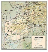
Afghanistan , officially the Islamic Republic of Afghanistan, is a landlocked country located in the centre of Asia, forming South Asia, Central Asia and the Middle East. With a population of about 29 million, it has an area of , making it the 42nd most populous and 41st largest nation in the world...
is a landlocked
Landlocked
A landlocked country is a country entirely enclosed by land, or whose only coastlines lie on closed seas. There are 48 landlocked countries in the world, including partially recognized states...
nation located in Central Asia
Central Asia
Central Asia is a core region of the Asian continent from the Caspian Sea in the west, China in the east, Afghanistan in the south, and Russia in the north...
. Strategically located at the crossroads of major north-south and east-west trade routes, it has attracted a succession of invaders including Alexander the Great, in the fourth century B.C. Currently, the United States
United States
The United States of America is a federal constitutional republic comprising fifty states and a federal district...
continues the global war on terrorism
War on Terrorism
The War on Terror is a term commonly applied to an international military campaign led by the United States and the United Kingdom with the support of other North Atlantic Treaty Organisation as well as non-NATO countries...
there.
Kabul, is the capital and largest city of Afghanistan, located in the Kabul Province. According to the 2008 official estimates, the population of Kabul metropolitan area is 2.8 million people.
The Hindu Kush
Hindu Kush
The Hindu Kush is an mountain range that stretches between central Afghanistan and northern Pakistan. The highest point in the Hindu Kush is Tirich Mir in the Chitral region of Khyber-Pakhtunkhwa, Pakistan.It is the westernmost extension of the Pamir Mountains, the Karakoram Range, and is a...
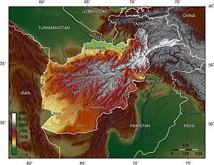
mountains, running northeast to southwest across the country, divide it into three major regions: 1) the Central Highlands, which form part of the Himalayas
Himalayas
The Himalaya Range or Himalaya Mountains Sanskrit: Devanagari: हिमालय, literally "abode of snow"), usually called the Himalayas or Himalaya for short, is a mountain range in Asia, separating the Indian subcontinent from the Tibetan Plateau...
and account for roughly two thirds of the country’s area; 2) the Southwestern Plateau, which accounts for one-fourth of the land; and 3) the smaller Northern Plains area, which contains the country’s most fertile soil.
Land elevations generally slope from northeast to southwest, following the general shape of the Hindu Kush massif, from its highest point in the Pamir Mountains
Pamir Mountains
The Pamir Mountains are a mountain range in Central Asia formed by the junction or knot of the Himalayas, Tian Shan, Karakoram, Kunlun, and Hindu Kush ranges. They are among the world’s highest mountains and since Victorian times they have been known as the "Roof of the World" a probable...
near the Chinese border to the lower elevations near the border with Iran
Iran
Iran , officially the Islamic Republic of Iran , is a country in Southern and Western Asia. The name "Iran" has been in use natively since the Sassanian era and came into use internationally in 1935, before which the country was known to the Western world as Persia...
. To the north, west, and southwest there are no mountain barriers to neighboring countries. The northern plains pass almost imperceptibly into the plains of Turkmenistan. In the west and southwest, the plateaus and deserts merge into those of Iran. Afghanistan is located on the Eurasian Tectonic Plate
Eurasian Plate
The Eurasian Plate is a tectonic plate which includes most of the continent of Eurasia , with the notable exceptions of the Indian subcontinent, the Arabian subcontinent, and the area east of the Chersky Range in East Siberia...
. The Wakhan Corridor
Wakhan Corridor
Wakhan Corridor is commonly used as a synonym for Wakhan, an area of far north-eastern Afghanistan which forms a land link or "corridor" between Afghanistan and China. The Corridor is a long and slender panhandle or salient, roughly long and between wide. It separates Tajikistan in the north...
and the rest of northeastern Afghanistan, including Kabul
Kabul
Kabul , spelt Caubul in some classic literatures, is the capital and largest city of Afghanistan. It is also the capital of the Kabul Province, located in the eastern section of Afghanistan...
, are situated in a geologically active area. Over a dozen earthquakes occurred there during the twentieth century.
The greater part of the northern border and a small section of the border with Pakistan are marked by rivers; the remaining boundary lines are political rather than natural. The northern frontier extends approximately 1689 km (1,049.5 mi) southwestward, from the Pamir Mountains in the northeast to a region of hills and deserts in the west, at the border with Iran. The border with Iran runs generally southward from the Hari River across swamp and desert regions before reaching the northwestern tip of Pakistan. Its southern
section crosses the Helmand River
Helmand River
The Helmand River is the longest river in Afghanistan and the primarily watershed for the endorheic Sistan Basin....
.
Afghanistan is bounded by six different countries. Its longest border is the poorly marked Durand Line
Durand Line
The Durand Line refers to the porous international border between Pakistan and Afghanistan, which has divided the ethnic Pashtuns . This poorly marked line is approximately long...
, accounting for its entire southern and eastern boundary with Pakistan
Pakistan
Pakistan , officially the Islamic Republic of Pakistan is a sovereign state in South Asia. It has a coastline along the Arabian Sea and the Gulf of Oman in the south and is bordered by Afghanistan and Iran in the west, India in the east and China in the far northeast. In the north, Tajikistan...
. The shortest one, bordering China
China
Chinese civilization may refer to:* China for more general discussion of the country.* Chinese culture* Greater China, the transnational community of ethnic Chinese.* History of China* Sinosphere, the area historically affected by Chinese culture...
’s Xinjiang
Xinjiang
Xinjiang is an autonomous region of the People's Republic of China. It is the largest Chinese administrative division and spans over 1.6 million km2...
province, is a mere 76 km at the end of the Wakhan Corridor
Wakhan Corridor
Wakhan Corridor is commonly used as a synonym for Wakhan, an area of far north-eastern Afghanistan which forms a land link or "corridor" between Afghanistan and China. The Corridor is a long and slender panhandle or salient, roughly long and between wide. It separates Tajikistan in the north...
(the Afghan Panhandle), a narrow sliver of land 241 km (149.8 mi) long that extends eastward between Tajikistan
Tajikistan
Tajikistan , officially the Republic of Tajikistan , is a mountainous landlocked country in Central Asia. Afghanistan borders it to the south, Uzbekistan to the west, Kyrgyzstan to the north, and China to the east....
and Pakistan. At its narrowest point it is only 11 km (7 mi) wide.
The border with Pakistan runs eastward from Iran through the Chagai Hills
Chagai Hills
The Chagai Hills is a range of granite hills in the Chagai District in Pakistan's Balochistan province.-Location:The Chagai Hills lie in a desert area in the northernmost part of Chagai District north of Pakistan's Ras Koh Hills and south of Afghanistan's Helmand and Nimruz provinces.- Topography...
and the southern end of the Registan Desert
Registan Desert
The Registan Desert is an extremely arid plateau region located between Helmand and Kandahar provinces in southwestern Afghanistan. It is a sandy desert consisting of small, red sandhills about 50 to high, sand covered planes, and open rocky and clay areas. It is sparsely populated by Baluchi and...
, then northward through mountainous country. It then follows an irregular northeasterly course before reaching the Durand Line, established in 1893. This line continues on through mountainous regions to the Khyber Pass
Khyber Pass
The Khyber Pass, is a mountain pass linking Pakistan and Afghanistan.The Pass was an integral part of the ancient Silk Road. It is mentioned in the Bible as the "Pesh Habor," and it is one of the oldest known passes in the world....
area. Beyond this point it rises to the crest of the Hindu Kush, which it follows eastward to the Pamir Mountains
Pamir Mountains
The Pamir Mountains are a mountain range in Central Asia formed by the junction or knot of the Himalayas, Tian Shan, Karakoram, Kunlun, and Hindu Kush ranges. They are among the world’s highest mountains and since Victorian times they have been known as the "Roof of the World" a probable...
. The Durand Line divides the Pashtun tribes
Pashtun tribes
The Pashtun people are the largest ethnic group in Afghanistan and the second largest in Pakistan. Pashtun, tribes are divided into four supertribal confederacies: the Arbanee , Betanee , Gharghasht, and Karlanee .Traditionally, according to folklore, all Pashtuns are said to have descended, at...
of the region between Afghanistan and Pakistan. Its creation has caused much dissatisfaction among Afghans and has given rise to political tensions between the two countries.
Mountain systems
The Hindu KushHindu Kush
The Hindu Kush is an mountain range that stretches between central Afghanistan and northern Pakistan. The highest point in the Hindu Kush is Tirich Mir in the Chitral region of Khyber-Pakhtunkhwa, Pakistan.It is the westernmost extension of the Pamir Mountains, the Karakoram Range, and is a...
reaches a height of 7492 m (24,580.1 ft) at Noshaq
Noshaq
Noshaq is the highest mountain in Afghanistan and the second highest independent peak of the Hindu Kush after Tirich Mir . Noshaq is located in the northeastern corner of the country along the Durand line which marks the border with Pakistan. It is the westernmost peak in the world...
, Afghanistan's highest peak. Of the ranges extending southwestward from the Hindu Kush, the Foladi peak (Shah Fuladi) of the Baba mountain range (Koh-i-Baba
Koh-i-Baba
The Baba mountain range is a western extension of the Hindu Kush, and the origin of all three of Afghanistan’s major river systems, the Kabul, the Hilmand-Arghandab, and the Hari River. It is crowned by Foladi peak rising 4951 m; 16,244 ft...
) reaches the greatest height: 5142 m (16,870.1 ft). The Safed Koh
Safed Koh
Spin Ghar or Safed Kuh or the Indian Caucasus, also known as the Safīd Mountain Range or Morga Range, is a mountain range on the Pakistan-Afghanistan border, up to above sea-level at Mount Sikaram, straight and rigid, towering above all surrounding hills...
range, which includes the Tora Bora area, dominates the border area southeast of Kabul
Kabul
Kabul , spelt Caubul in some classic literatures, is the capital and largest city of Afghanistan. It is also the capital of the Kabul Province, located in the eastern section of Afghanistan...
.
Important passes include the Unai Pass
Unai Pass
Unai Pass traverses the Sanglakh Range, an offshoot of the Hindukush, west of Kabul. It is the main road connection of Kabul with Hazarajat....
across the Safed Koh
Safed Koh
Spin Ghar or Safed Kuh or the Indian Caucasus, also known as the Safīd Mountain Range or Morga Range, is a mountain range on the Pakistan-Afghanistan border, up to above sea-level at Mount Sikaram, straight and rigid, towering above all surrounding hills...
, the Kushan
Kushan Pass
The Kushan Pass or Kaoshan Pass is a mountain pass just west of the famous Salang Pass in the Hindu Kush mountain range of northern Afghanistan...
and Salang Passes through the Hindu Kush, and the Khyber Pass
Khyber Pass
The Khyber Pass, is a mountain pass linking Pakistan and Afghanistan.The Pass was an integral part of the ancient Silk Road. It is mentioned in the Bible as the "Pesh Habor," and it is one of the oldest known passes in the world....
that connects Afghanistan with Pakistan. The summit of the Khyber Pass at 1070 m (3,510.5 ft) at Landi Kotal
Landi Kotal
Landi Kotal or Landikotal is a town of the Federally Administered Tribal Areas of Pakistan. It is located at 34°6'4N 71°8'44E and lies on the Khyber Pass in the Khyber Agency. At 1,072 metres above sea level it is the highest point on the Khyber Pass and is the route across the mountains to the...
, Pakistan is 5 km (3 mi) east of the border town of Torkham
Torkham
Torkham is a border crossing town in the Nangarhar province of Afghanistan and the Khyber Agency of Pakistan's Federally Administered Tribal Areas, right on the Durand Line border....
. Other key passages through the mountainous Pakistan border include two from Paktika Province into Pakistan's Waziristan
Waziristan
Waziristan is a mountainous region near the Northwest of Pakistan, bordering Afghanistan and covering some 11,585 km² . The area is entirely populated by ethnic Pashtuns . The language spoken in the valley is Pashto/Pakhto...
region: one at Angoor Ada
Angoor Ada
Angoor Ada is a village and a border crossing straddling the South Waziristan Agency of Pakistan's Federally Administered Tribal Areas and Afghanistan's Paktika Province...
, a village that straddles both sides of the border east of Shkin
Shkin
Shkin is a scattered village in Barmal District, Paktika Province, Afghanistan located about a kilometer west of the newer, much larger, and border-straddling village and bazaar of Angoor Adda. Angoor Adda is controlled by the Pakistan Frontier Guards...
, and, further south, the Gumal River crossing, plus the Charkai River passage south of Khowst, Afghanistan, at Pakistan's Ghulam Khan
Ghulam Khan
Ghulam Khan is town in North Waziristan, FATA, Pakistan. Ghulam Khan is on the border between Pakistan and Afghanistan. It is the third most important border crossing point between Pakistan and Afghanistan, after Chaman and Torkham....
village into North Waziristan
North Waziristan
North Waziristan is the northern part of Waziristan, a mountainous region of northwest Pakistan, bordering Afghanistan and covering . Waziristan comprises the area west and south-west of Peshawar between the Tochi river to the north and the Gomal river to the south, forming part of Pakistan's...
. The busy Pakistan border crossing at Wesh, just northwest of Chaman
Chaman
Chaman is the capital of Qilla Abdullah District, Balochistan, Pakistan. It is situated just south of the border with Afghanistan. Across the border in Afghanistan is the neighbouring town of Spin Boldak, in Kandahar Province...
, Pakistan, connecting Kandahar
Kandahar
Kandahar is the second largest city in Afghanistan, with a population of about 512,200 as of 2011. It is the capital of Kandahar Province, located in the south of the country at about 1,005 m above sea level...
and Spin Boldak
Spin Boldak
Spin Boldak or Spin Buldak is a border town in the southern Kandahar province of Afghanistan, right next to the Durand Line border with Pakistan. It is linked by a highway with the city of Kandahar to the north, and with Chaman and Quetta in Pakistan to the south. Spin Boldak has the second major...
, Afghanistan, to Quetta
Quetta
is the largest city and the provincial capital of the Balochistan Province of Pakistan. Known as the "Fruit Garden of Pakistan" due to the diversity of its plant and animal wildlife, Quetta is home to the Hazarganji Chiltan National Park, which contains some of the rarest species of wildlife in the...
, Pakistan, is in a flat, dry area, though this route involves Pakistan's Khojak Pass
Khojak Pass
Khojak Pass connects Qila Abdullah with Chaman in the province of Baluchistan, Pakistan.* Khojak Pass is between Quetta and Chaman...
at 2707 m (8,881.2 ft) just 14 km (9 mi) from the border.
The Wakhan Corridor
Wakhan Corridor
Wakhan Corridor is commonly used as a synonym for Wakhan, an area of far north-eastern Afghanistan which forms a land link or "corridor" between Afghanistan and China. The Corridor is a long and slender panhandle or salient, roughly long and between wide. It separates Tajikistan in the north...
in the northeast lies between the Hindu Kush and the Pamir Mountains
Pamir Mountains
The Pamir Mountains are a mountain range in Central Asia formed by the junction or knot of the Himalayas, Tian Shan, Karakoram, Kunlun, and Hindu Kush ranges. They are among the world’s highest mountains and since Victorian times they have been known as the "Roof of the World" a probable...
, which leads to the Wakhjir Pass
Wakhjir Pass
The Wakhjir Pass is a mountain pass in the Hindu Kush or Pamirs at the eastern end of the Wakhan Corridor, the only pass between Afghanistan and China. It links Wakhan in Afghanistan with the Tashkurgan Tajik Autonomous County in Xinjiang, China, at an altitude of 4,923 m, but the pass is not an...
into Xinjiang
Xinjiang
Xinjiang is an autonomous region of the People's Republic of China. It is the largest Chinese administrative division and spans over 1.6 million km2...
in China
China
Chinese civilization may refer to:* China for more general discussion of the country.* Chinese culture* Greater China, the transnational community of ethnic Chinese.* History of China* Sinosphere, the area historically affected by Chinese culture...
. Taking the highlands of the country as a whole, there is no great difference between the mean temperature of Afghanistan and that of the lower Himalaya. Each may be placed at a point between . However, the remarkable feature of Afghan climate is its extreme range of temperature within limited periods. The smallest daily range in the north is when the weather is cold; the greatest is when it is hot. For seven months of the year (from May to November) this range exceeds 17 C-change daily. Waves of intense cold occur, lasting for several days, and one may have to endure a cold of -24 °C, rising to a maximum of -8 °C. On the other hand, the summer temperature is exceedingly high, especially in the Oxus regions, where a shade maximum of 45–50 °C (113–122 F) is not uncommon. At Kabul, and over all the northern part of the country to the descent at Gandamak
Gandamak
-Description:The village is located between Kabul and Peshawar, from Jalalabad on the old road to Kabul. On the retreat from Kabul of General Elphinstone's army in 1842, a hill near Gandamak was the scene of the Battle of Gandamak, the massacre of the last survivors of the force: twenty officers...
, winter is rigorous, but especially so on the high Arachosian plateau. In Kabul the snow lies for two or three months; the people seldom leave their houses, and sleep close to stoves. At Ghazni the snow has been known to lie long beyond the vernal equinox; the thermometer sinks as low as -25 °C, and tradition relates the destruction of the entire population of Ghazni by snowstorms more than once.
Sistan Basin
The Sistan Basin is an inland endorheic basin encompassing large parts of southwestern Afghanistan and southeastern Iran, one of the driest regions in the world and an area subjected to prolonged droughts...
, Jalalabad
Jalalabad
Jalalabad , formerly called Adinapour, as documented by the 7th century Hsüan-tsang, is a city in eastern Afghanistan. Located at the junction of the Kabul River and Kunar River near the Laghman valley, Jalalabad is the capital of Nangarhar province. It is linked by approximately of highway with...
and Turkestan
Afghan Turkestan
Afghan Turkestan is a region in northern Afghanistan, on the border with the former Soviet republics of Turkmenistan, Uzbekistan and Tajikistan. It was the name of a former province in this area until its division by Abdur Rahman, and was centred on Mazari Sharif and included territory in the...
, especially Sistan. All over Kandahar province the summer heat is intense, and the simoom
Simoom
Simoom is a strong, dry, dust-laden local wind that blows in the Sahara, Palestine, Israel, Jordan, Syria, and the deserts of Arabian Peninsula. Alternative spellings include samiel, sameyel, samoon, samun, simoun, and simoon...
is not unknown. The hot season throughout this part of the country is rendered more trying by frequent dust storms and fiery winds; whilst the bare rocky ridges that traverse the country, absorbing heat by day and radiating it by night, render the summer nights most oppressive. At Kabul the summer sun has great power, though the heat is tempered occasionally by cool breezes from the Hindu Kush
Hindu Kush
The Hindu Kush is an mountain range that stretches between central Afghanistan and northern Pakistan. The highest point in the Hindu Kush is Tirich Mir in the Chitral region of Khyber-Pakhtunkhwa, Pakistan.It is the westernmost extension of the Pamir Mountains, the Karakoram Range, and is a...
, and the nights are usually cool. At Kandahar snow seldom falls on the plains or lower hills; when it does, it melts at once.
Although Herat
Herat
Herāt is the capital of Herat province in Afghanistan. It is the third largest city of Afghanistan, with a population of about 397,456 as of 2006. It is situated in the valley of the Hari River, which flows from the mountains of central Afghanistan to the Karakum Desert in Turkmenistan...
is approximately 240 m (787 ft) lower than Kandahar, the summer climate there is more temperate, and the climate throughout the year is far from disagreeable. From May to September, the wind blows from the northwest with great force, and this extends across the country to Kandahar. The winter is tolerably mild; snow melts as it falls, and even on the mountains does not lie long. Three years out of four at Herat it does not freeze hard enough for the people to store ice; yet it was not very far from Herat, and could not have been at a greatly higher level (at Rafir Kala, near Kassan) that, in 1750, Ahmad Shah's army, retreating from Persia, is said to have lost 18,000 men from cold in a single night. In the northern Herat districts, too, records of the coldest month (February) show the mean minimum as -8 °C and the maximum as 3 °C (37.4 °F). The eastern reaches of the Hari River, including the rapids, are frozen hard in the winter, and people travel on it as on a road.
The summer rains that accompany the southwest monsoon in India
India
India , officially the Republic of India , is a country in South Asia. It is the seventh-largest country by geographical area, the second-most populous country with over 1.2 billion people, and the most populous democracy in the world...
, beating along the southern slopes of the Himalaya, travel up the Kabul valley as far as Laghman, though they are more clearly felt in Bajour and Panjkora, under the high spurs of the Hindu Kush
Hindu Kush
The Hindu Kush is an mountain range that stretches between central Afghanistan and northern Pakistan. The highest point in the Hindu Kush is Tirich Mir in the Chitral region of Khyber-Pakhtunkhwa, Pakistan.It is the westernmost extension of the Pamir Mountains, the Karakoram Range, and is a...
, and in the eastern branches of Safed Koh
Safed Koh
Spin Ghar or Safed Kuh or the Indian Caucasus, also known as the Safīd Mountain Range or Morga Range, is a mountain range on the Pakistan-Afghanistan border, up to above sea-level at Mount Sikaram, straight and rigid, towering above all surrounding hills...
. Rain also falls at this season at the head of Kurram
Kurram
Kurram can refer to either:*Kurram River - a river on the border between Afghanistan and Pakistan*Kurram Valley - the valley of the Kurram River which runs from Afghanistan to the Indus River....
valley. South of this the Suliman mountains may be taken as the western limit of the monsoon's action. It is quite unfelt in the rest of Afghanistan, in which, as in all the west of Asia, the winter rains are the most considerable. The spring rain, though less copious, is more important to agriculture than the winter rain, unless where the latter falls in the form of snow. In the absence of monsoon influences there are steadier weather indications than in India. The north-west blizzards which occur in winter and spring are the most noticeable feature, and their influence is clearly felt on the Indian frontier. The cold is then intense and the force of the wind cyclonic. Speaking generally, the Afghanistan climate is a dry one. The sun shines with splendor for three-fourths of the year, and the nights are even more clear than the days. Marked characteristics are the great differences of summer and winter temperature and of day and night temperature, as well as the extent to which change of climate can be attained by slight change of place. The highest temperature ever recorded under standard conditions was 49.9 °C (121.8 °F) at Farah in August 2009 and the lowest was -52.2 °C at Shahrak in January 1964.
The emperor Babur
Babur
Babur was a Muslim conqueror from Central Asia who, following a series of setbacks, finally succeeded in laying the basis for the Mughal dynasty of South Asia. He was a direct descendant of Timur through his father, and a descendant also of Genghis Khan through his mother...
observed:
Rivers and lakes
River
A river is a natural watercourse, usually freshwater, flowing towards an ocean, a lake, a sea, or another river. In a few cases, a river simply flows into the ground or dries up completely before reaching another body of water. Small rivers may also be called by several other names, including...
s, lake
Lake
A lake is a body of relatively still fresh or salt water of considerable size, localized in a basin, that is surrounded by land. Lakes are inland and not part of the ocean and therefore are distinct from lagoons, and are larger and deeper than ponds. Lakes can be contrasted with rivers or streams,...
s, and stream
Stream
A stream is a body of water with a current, confined within a bed and stream banks. Depending on its locale or certain characteristics, a stream may be referred to as a branch, brook, beck, burn, creek, "crick", gill , kill, lick, rill, river, syke, bayou, rivulet, streamage, wash, run or...
s, but most of its national water flows to neighboring states. It loses about two-thirds of its water from snow and rain annually, which flows mainly to Pakistan, Iran and Tajikistan. The country needs several billion dollars to rehabilitate its irrigation systems so that the water is properly used. The Afghan government is asking for a $12 billion investment from the international community to construct a number of dam
Dam
A dam is a barrier that impounds water or underground streams. Dams generally serve the primary purpose of retaining water, while other structures such as floodgates or levees are used to manage or prevent water flow into specific land regions. Hydropower and pumped-storage hydroelectricity are...
s for the production of electricity and to help the irrigation of the country. The nation's drainage system is essentially landlocked. Most of the rivers and streams end in shallow desert lakes or oases inside or outside the country’s boundaries. Nearly half of the country's total area is drained by watercourses south of the Hindu Kush–Safid ridge line, and half of this area is drained by the Helmand
Helmand River
The Helmand River is the longest river in Afghanistan and the primarily watershed for the endorheic Sistan Basin....
and its tributaries alone. The Amu Darya
Amu Darya
The Amu Darya , also called Oxus and Amu River, is a major river in Central Asia. It is formed by the junction of the Vakhsh and Panj rivers...
on the northern border, the country's other major river, has the next largest drainage area.
The 2661 km (1,653.5 mi) long Amu Darya
Amu Darya
The Amu Darya , also called Oxus and Amu River, is a major river in Central Asia. It is formed by the junction of the Vakhsh and Panj rivers...
originates in the glaciers of the Pamir Mountains
Pamir Mountains
The Pamir Mountains are a mountain range in Central Asia formed by the junction or knot of the Himalayas, Tian Shan, Karakoram, Kunlun, and Hindu Kush ranges. They are among the world’s highest mountains and since Victorian times they have been known as the "Roof of the World" a probable...
in the northeast. Some 965 km of its upper course constitutes Afghanistan's border with Turkmenistan, Uzbekistan and Tajikistan. Flowing in rapid torrents in its upper course, the Amu Darya becomes calmer below the mouth of the Kokcha
Kokcha River
The Kokcha River is a river of northeastern Afghanistan. A tributary of the Amu Darya river, it flows through Badakhshan Province in the Hindu Kush range of Afghan Turkestan. The city of Feyzabad lies along the Kokcha. Near the village of Artin Jelow there is a bridge over the river.The Kokcha...
, 96 km (59.7 mi) west of Fayzabad
Fayzabad, Badakhshan
See also: Faizabad Fayzabad is the provincial capital and largest city in Badakhshan Province, in northern Afghanistan, with around 50,000 people. It is situated in Fayzabad District and is at an altitude of 1,200 m. It is located in the northeast of Afghanistan, on the River Kokcha...
. The Kunduz River
Kunduz River
The Kunduz River is a tributary of the Amu Darya in northern Afghanistan. It rises in the Hindu Kush, and in its upper reaches is known as the Surkhab River.-Course:...
is another major tributary. During its flood period the upper course of the Amu Darya, swollen by snow and melting ice, carries along much gravel and large boulders.
The Helmand River
Helmand River
The Helmand River is the longest river in Afghanistan and the primarily watershed for the endorheic Sistan Basin....
is the principal river in the southwest, bisecting the entire region. Starting some 80 km (49.7 mi) west of Kabul
Kabul
Kabul , spelt Caubul in some classic literatures, is the capital and largest city of Afghanistan. It is also the capital of the Kabul Province, located in the eastern section of Afghanistan...
in the Baba mountain range, the Helmand is approximately 1400 km (869.9 mi) long, making it the longest river situated entirely within Afghanistan. With its many tributaries, the most important of which is the Arghandab River
Arghandab River
Arghandab is a river in Afghanistan, about in length. It rises in the Hazarajat country north-west of Ghazni, and flows south-west falls into the Helmand below Girishk. In its lower course it is much used for irrigation, and the valley is cultivated and populous; yet the water is said to be...
, it drains more than 298 km² (115.1 sq mi).
The Kabul River
Kabul River
Kabul River , the classical Cophes , is a 700 km long river that starts in the Sanglakh Range of the Hindu Kush Mountains in Afghanistan and ends in the Indus River near Attock, Pakistan. It is the main river in eastern Afghanistan and is separated from the watershed of the Helmand by the Unai Pass...
, 515 km (320 mi) long, is a vital source of water in the Baba Mountains and for Kabul itself, which it flows through. The Kabul and its tributaries are among the few in Afghanistan that eventually reach the sea, as it flows east into the Indus River
Indus River
The Indus River is a major river which flows through Pakistan. It also has courses through China and India.Originating in the Tibetan plateau of western China in the vicinity of Lake Mansarovar in Tibet Autonomous Region, the river runs a course through the Ladakh district of Jammu and Kashmir and...
in Pakistan.
In the west the sandy deserts along most of the Iranian frontier have no watercourses. However, in the northwest, the Hari
Hari River
Hari River may refer to:* Hari River, Afghanistan, one of the three major rivers of Afghanistan* Batang Hari River, the longest river in Sumatra, Indonesia...
and Morghab Rivers flow into Turkmenistan's Karakum Desert
Karakum Desert
The Karakum Desert, also spelled Kara-Kum and Gara Gum is a desert in Central Asia. It occupies about 70 percent, or 350,000 km², of the area of Turkmenistan....
.
Vegetation
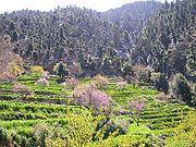
Take, for example, the Safed Koh. On the alpine range itself and its immediate branches, at a height of 1800–3000 m (5,905.5–9,842.5 ft) there is abundant growth of large forest trees, among which conifers are the most noble and prominent, such as Cedrus deodara, Abies excelsa, Pinus longifolia, Pinus pinaster, Stone pine (the edible pine, although this species is probably introduced, since it is original to Spain
Spain
Spain , officially the Kingdom of Spain languages]] under the European Charter for Regional or Minority Languages. In each of these, Spain's official name is as follows:;;;;;;), is a country and member state of the European Union located in southwestern Europe on the Iberian Peninsula...
and Portugal
Portugal
Portugal , officially the Portuguese Republic is a country situated in southwestern Europe on the Iberian Peninsula. Portugal is the westernmost country of Europe, and is bordered by the Atlantic Ocean to the West and South and by Spain to the North and East. The Atlantic archipelagos of the...
) and the larch. There is also the yew
Taxus
Taxus is a genus of yews, small coniferous trees or shrubs in the yew family Taxaceae. They are relatively slow-growing and can be very long-lived, and reach heights of 1-40 m, with trunk diameters of up to 4 m...
, the hazel
Hazel
The hazels are a genus of deciduous trees and large shrubs native to the temperate northern hemisphere. The genus is usually placed in the birch family Betulaceae, though some botanists split the hazels into a separate family Corylaceae.They have simple, rounded leaves with double-serrate margins...
, juniper
Juniper
Junipers are coniferous plants in the genus Juniperus of the cypress family Cupressaceae. Depending on taxonomic viewpoint, there are between 50-67 species of juniper, widely distributed throughout the northern hemisphere, from the Arctic, south to tropical Africa in the Old World, and to the...
, walnut
Walnut
Juglans is a plant genus of the family Juglandaceae, the seeds of which are known as walnuts. They are deciduous trees, 10–40 meters tall , with pinnate leaves 200–900 millimetres long , with 5–25 leaflets; the shoots have chambered pith, a character shared with the wingnuts , but not the hickories...
, wild peach and almond
Almond
The almond , is a species of tree native to the Middle East and South Asia. Almond is also the name of the edible and widely cultivated seed of this tree...
. Growing under the shade of these are several varieties of rose
Rose
A rose is a woody perennial of the genus Rosa, within the family Rosaceae. There are over 100 species. They form a group of erect shrubs, and climbing or trailing plants, with stems that are often armed with sharp prickles. Flowers are large and showy, in colours ranging from white through yellows...
, honeysuckle
Honeysuckle
Honeysuckles are arching shrubs or twining vines in the family Caprifoliaceae, native to the Northern Hemisphere. There are about 180 species of honeysuckle, 100 of which occur in China; Europe, India and North America have only about 20 native species each...
, currant
Ribes
Ribes is a genus of about 150 species of flowering plants native throughout the temperate regions of the Northern Hemisphere. It is usually treated as the only genus in the family Grossulariaceae. Seven subgenera are recognized....
, gooseberry
Gooseberry
The gooseberry or ; Ribes uva-crispa, syn. R. grossularia) is a species of Ribes, native to Europe, northwestern Africa and southwestern Asia...
, hawthorn
Crataegus
Crataegus , commonly called hawthorn or thornapple, is a large genus of shrubs and trees in the rose family, Rosaceae, native to temperate regions of the Northern Hemisphere in Europe, Asia and North America. The name hawthorn was originally applied to the species native to northern Europe,...
, rhododendron
Rhododendron
Rhododendron is a genus of over 1 000 species of woody plants in the heath family, most with showy flowers...
and a luxuriant herbage, among which the ranunculus family is important for frequency and number of genera. The lemon and wild vine are also here met with, but are more common on the northern mountains. The walnut and oak (evergreen, holly-leaved and kermes) descend to the secondary heights, where they become mixed with alder, ash, khinjak, Arbor-vitae, juniper, with species of Astragalus, &c. Here also are Indigoferae rind dwarf laburnum.
Down to 1000 m (3,280.8 ft) there are wild olive, species of rock-rose, wild privet, acacias and mimosas, barberry and Zizyphus; and in the eastern ramifications of the chain, Chamaerops humilis (which is applied to a variety of useful purposes, and which it is also introduced since it is original to Western Mediterranean), Bignonia
Bignonia
Bignonia is a genus of flowering plants in the catalpa family, Bignoniaceae. Its genus and family were named after Jean-Paul Bignon by his protégé Joseph Pitton de Tournefort in 1694.-Selected species:*Bignonia capreolata...
or trumpet flower, sissu, Salvadora persica
Salvadora persica
Salvadora persica , is a species of Salvadora....
, verbena, acanthus, varieties of Gesnerae.
The lowest terminal ridges, especially towards the west, are, as it has been said, naked in aspect. Their scanty vegetation is almost wholly herbal; shrubs are only occasional; trees almost non-existent. Labiate, composite and umbelliferous plants are most common. Fern
Fern
A fern is any one of a group of about 12,000 species of plants belonging to the botanical group known as Pteridophyta. Unlike mosses, they have xylem and phloem . They have stems, leaves, and roots like other vascular plants...
s and moss
Moss
Mosses are small, soft plants that are typically 1–10 cm tall, though some species are much larger. They commonly grow close together in clumps or mats in damp or shady locations. They do not have flowers or seeds, and their simple leaves cover the thin wiry stems...
es are almost confined to the higher ranges.
In the low brushwood scattered over portions of the dreary plains of the Kandahar tablelands, it is possible to find leguminous thorny plants of the papilionaceous suborder, such as camel-thorn (Hedysarum alhagi
Hedysarum
Hedysarum is a genus of the botanical family Fabaceae, consisting of about 309 species of annual or perennial herbs in Asia, Europe, North Africa, and North America.-Description:...
), Astragalus
Astragalus
Astragalus is a large genus of about 3,000 species of herbs and small shrubs, belonging to the legume family Fabaceae, subfamily Faboideae. The genus is native to temperate regions of the Northern Hemisphere...
in several varieties, spiny rest-harrow (Ononis
Ononis
Ononis is a large genus of perennial herbs and shrubs from the legume family Fabaceae. The members of this genus are often called restharrows as some species are arable weeds whose tough stems would stop the harrow...
spinosa), the fibrous roots of which often serve as a tooth-brush; plants of the sub-order Mimosa
Mimosa
Mimosa is a genus of about 400 species of herbs and shrubs, in the subfamily Mimosoideae of the legume family Fabaceae. The generic name is derived from the Greek word μιμος , meaning "mimic."...
e, as the sensitive mimosa; a plant of the rue
Rue
Rue is a genus of strongly scented evergreen subshrubs 20–60 cm tall, in the family Rutaceae, native to the Mediterranean region, Macaronesia and southwest Asia. There are perhaps 8 to 40 species in the genus...
family, called by the natives lipad; the common wormwood
Artemisia (plant)
Artemisia is a large, diverse genus of plants with between 200 to 400 species belonging to the daisy family Asteraceae. It comprises hardy herbs and shrubs known for their volatile oils. They grow in temperate climates of the Northern Hemisphere and Southern Hemisphere, usually in dry or semi-dry...
; also certain orchids, and several species of Salsola. The rue and wormwood are in general use as domestic medicines—the former for rheumatism
Rheumatism
Rheumatism or rheumatic disorder is a non-specific term for medical problems affecting the joints and connective tissue. The study of, and therapeutic interventions in, such disorders is called rheumatology.-Terminology:...
and neuralgia
Neurasthenia
Neurasthenia is a psycho-pathological term first used by George Miller Beard in 1869 to denote a condition with symptoms of fatigue, anxiety, headache, neuralgia and depressed mood...
; the latter in fever, debility and dyspepsia, as well as for a vermifuge. The lipad, owing to its heavy nauseous odour, is believed to keep off evil spirits. In some places, occupying the sides and hollows of ravines, it is found the Rose Bay, called in Persian khar-zarah, or ass-bane, the wild laburnum
Laburnum
Laburnum is a genus of two species of small trees in the subfamily Faboideae of the pea family Fabaceae, Laburnum anagyroides and L. alpinum . They are native to the mountains of southern Europe from France to the Balkan Peninsula...
and various Indigoferae.
In cultivated districts the chief trees seen are mulberry
Mulberry
Morus is a genus of flowering plants in the family Moraceae. The 10–16 species of deciduous trees it contains are commonly known as Mulberries....
, willow
Willow
Willows, sallows, and osiers form the genus Salix, around 400 species of deciduous trees and shrubs, found primarily on moist soils in cold and temperate regions of the Northern Hemisphere...
, poplar spp. ash
Ash tree
Fraxinus is a genus flowering plants in the olive and lilac family, Oleaceae. It contains 45-65 species of usually medium to large trees, mostly deciduous though a few subtropical species are evergreen. The tree's common English name, ash, goes back to the Old English æsc, while the generic name...
, and occasionally the plane
Platanus
Platanus is a small genus of trees native to the Northern Hemisphere. They are the sole living members of the family Platanaceae....
; but these are because of man's planting.
During the last 30 years of war, 90% of forests in Afghanistan have been destroyed and exported to neighboring countries such as Pakistan. Afghanistan may be facing a serious environmental crisis. A huge percent of Afghanistan's land could be subject to soil erosion and desertification
Desertification
Desertification is the degradation of land in drylands. Caused by a variety of factors, such as climate change and human activities, desertification is one of the most significant global environmental problems.-Definitions:...
.so people of Afghanistan must be aware of these critical problems.education is very important specially for farmers or land keepers so waterlogging and other problems can be controlled.
Further reading
- 1911 Encyclopædia Britannica - physical geography
- Central Intelligence Agency. "Afghanistan." CIA World Factbook 2000. 2004. https://www.cia.gov/library/publications/the-world-factbook/geos/af.html
- Federal Research Division, Library of Congress. "Afghanistan: A Country Study." 1997. http://lcweb2.loc.gov/frd/cs/aftoc.html
External links
- Topographic map of Afghanistan (1 : 300 000)
- Soil Maps of Afghanistan
- Article on Natural Resources in Afghanistan
- Assessment of Undiscovered Petroleum Resources of Northern Afghanistan, (2006)
- Institute for Afghan Studies Assessment on Resources (2001)
- e-map of Afghanistan
- [Washington post web side Death Valley http://www.washingtonpost.com/wpdyn/content/article/2010/04/14/AR2010041401012.html]
[*Dara peach Valley Ningarhar Province Sidehttp://www.stripes.com/news/middle-east/afghanistan/u-s-big-guns-resound-through-afghanistan-s-pech-river-valley-1.114152]
[*Replenishing Afghanistan's Arghandab River Valley http://www.afghanistan.gc.ca/canada-afghanistan/projects-projets/arghandab.aspx]