
Pamir Mountains
Encyclopedia
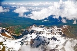
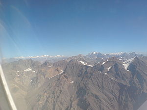
The Pamir Mountains are a mountain range
in Central Asia
formed by the junction or knot
of the Himalayas
, Tian Shan
, Karakoram
, Kunlun
, and Hindu Kush
ranges. They are among the world’s highest mountain
s and since Victorian times they have been known as the "Roof of the World
" a probable translation from the Persian.
The precise extent of the Pamir Mountains is debatable. They lie mostly in Gorno-Badakhshan
province, Tajikistan
and Badakshan Province, Afghanistan
. To the north they join the Tian Shan mountains along the Alay Valley
of Kyrgyzstan
. To the south they join the Hindu Kush mountains along the Wakhan Corridor
in Afghanistan
/Pakistan
, and also Gilgit-Baltistan in Pakistan
. To the east they may end on the Chinese border or extend to the range that includes Kongur Tagh
which is sometimes included in the Kunlun Mountains
.
The Pamir Mountains were prominently featured in the 1985 film, Spies Like Us
starring Chevy Chase
and Dan Aykroyd
. They were even described by Austin Milbarge (Aykroyd) as being "the roof of the world" and having "sub-Arctic temperatures".
), 7134 m (23,406 ft); and Peak Korzhenevskaya
, 7105 m (23,310 ft).
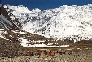
There are many glacier
s in the Pamir Mountains, including the 77 km (48 mi) long Fedchenko Glacier
, the longest in the former USSR
and the longest glacier outside the Polar region
.
throughout the year, the Pamirs have long and bitterly cold winter
s, and short, cool summer
s. Annual precipitation
is about 130 mm (5 in), which supports grassland
s but few tree
s.
is mined in the west, though sheep herding in upper meadowlands
are the primary source of income for the region.
The lapis lazuli
found in Egyptian tombs is thought to come from the Pamir area in Badakhshan province of Afghanistan. About 138 BC Zhang Qian
reached the Fergana Valley
northwest of the Pamirs. Ptolemy
vaguely describes a trade route though the area. From about 600 AD, Buddhist pilgrims travelled on both sides of the Pamirs to reach India from China. In 747 a Tang army was on the Wakhan River. There are various Arab and Chinese reports. Marco Polo
may have travelled along the Panj River
. In 1602 Bento de Goes
travelled from Kabul
to Yarkand and left a meager report on the Pamirs. In 1838 Lieutenant John Wood
reached the headwaters of the Pamir River
. From about 1868 to 1880, a number of Indians in the British service secretly explored the Panj area. In 1873 the British and Russians agreed to an Afghan frontier along the Panj River
. From 1871 to around 1893 several Russian military-scientific expeditions mapped out most of the Pamirs (Alexei Pavlovich Fedchenko
, Nikolai Severtzov, Captain Putyata
and others. Later came Nikolai Korzhenevskiy
). Several local groups asked for Russian protection from Afghan raiders. The Russians were followed by a number of non-Russians including Ney Elias
, George Littledale
, the Earl of Dunmore
, Wilhelm Filchner
and Lord Curzon who was probably the first to reach the Wakhan source of the Oxus River. In 1891 the Russians informed Francis Younghusband
that he was on their territory and later escorted a Lieutenant Davidson out of the area ('Pamir Incident'). In 1892 a battalion of Russians under Mikhail Ionov entered the area and camped near the present Murghab
. In 1893 they built a proper fort there (Pamirskiy Post). In 1895 their base was moved to Khorog facing the Afghans.
In 1928 the last blank areas around the Fedchenko Glacier
were mapped out by a German-Soviet expedition under Willi Rickmer Rickmers.
term. A pamir is a flat plateau or U-shaped valley surrounded by mountains. It forms when a glacier or ice field melts leaving a rocky plain. A pamir lasts until erosion forms soil and cuts down normal valleys. This type of terrain is found in the east and north of the Wakhan
, and the east and south of Gorno-Badakhshan, as opposed to the valleys and gorges of the west. Pamirs are used for summer pasture.
The Great Pamir
is around Lake Zorkul
. The Little Pamir
is east of this in the far east of Wakhan. The Taghdumbash Pamir
is between Tashkurgan
and the Wakhan
west of the Karakoram Highway
. The Alichur Pamir is around Yashil Kul on the Gunt River. The Sarez Pamir is around the town of Murghab
. The Khargush Pamir is south of Lake Karakul. There are several others.
The Pamir River
is in the south-west of the Pamirs.
 In the early 1980s, a deposit of gemstone
-quality clinohumite
was discovered in the Pamir Mountains. It was the only such deposit known until the discovery of gem-quality material in the Taymyr
region of Siberia
, in 2000.
, the world's second highest international road, runs from Dushanbe
in Tajikistan
to Osh
in Kyrgyzstan
through the Gorno-Badakhshan Autonomous Province
, and is the isolated region's main supply route. The Great Silk Road
crossed a number of Pamir Mountain ranges.
 Historically, the Pamir Mountains were considered a strategic trade route between Kashgar
and Kokand
on the Northern Silk Road
and have been subject to numerous territorial conquests. The Northern Silk Road (about 2600 km (1,616 mi) in length) connected the ancient Chinese capital of Xian to the west over the Pamir Mountains to emerge in Kashgar
before linking to ancient Parthia
. In the 20th century, they have been the setting for Tajikistan Civil War, border disputes between China and Soviet Union
, establishment of US, Russian, and Indian military bases, and renewed interest in trade development and resource exploration.
Mountain range
A mountain range is a single, large mass consisting of a succession of mountains or narrowly spaced mountain ridges, with or without peaks, closely related in position, direction, formation, and age; a component part of a mountain system or of a mountain chain...
in Central Asia
Central Asia
Central Asia is a core region of the Asian continent from the Caspian Sea in the west, China in the east, Afghanistan in the south, and Russia in the north...
formed by the junction or knot
Knot
A knot is a method of fastening or securing linear material such as rope by tying or interweaving. It may consist of a length of one or several segments of rope, string, webbing, twine, strap, or even chain interwoven such that the line can bind to itself or to some other object—the "load"...
of the Himalayas
Himalayas
The Himalaya Range or Himalaya Mountains Sanskrit: Devanagari: हिमालय, literally "abode of snow"), usually called the Himalayas or Himalaya for short, is a mountain range in Asia, separating the Indian subcontinent from the Tibetan Plateau...
, Tian Shan
Tian Shan
The Tian Shan , also spelled Tien Shan, is a large mountain system located in Central Asia. The highest peak in the Tian Shan is Victory Peak , ....
, Karakoram
Karakoram
The Karakoram, or Karakorum , is a large mountain range spanning the borders between Pakistan, India and China, located in the regions of Gilgit-Baltistan , Ladakh , and Xinjiang region,...
, Kunlun
Kunlun Mountains
The Kunlun Mountains are one of the longest mountain chains in Asia, extending more than 3,000 km. In the broadest sense, it forms the northern edge of the Tibetan Plateau south of the Tarim Basin and the Gansu Corridor and continues east south of the Wei River to end at the North China Plain.The...
, and Hindu Kush
Hindu Kush
The Hindu Kush is an mountain range that stretches between central Afghanistan and northern Pakistan. The highest point in the Hindu Kush is Tirich Mir in the Chitral region of Khyber-Pakhtunkhwa, Pakistan.It is the westernmost extension of the Pamir Mountains, the Karakoram Range, and is a...
ranges. They are among the world’s highest mountain
Mountain
Image:Himalaya_annotated.jpg|thumb|right|The Himalayan mountain range with Mount Everestrect 58 14 160 49 Chomo Lonzorect 200 28 335 52 Makalurect 378 24 566 45 Mount Everestrect 188 581 920 656 Tibetan Plateaurect 250 406 340 427 Rong River...
s and since Victorian times they have been known as the "Roof of the World
Roof of the World
Roof of the World is a metaphoric description of the highest region in the world, also known as "High Asia", or the Trans-Himalaya, the mountainous interior of Asia.The term is also used for parts of this region, for* the Pamirs,* Tibet* the Himalayas...
" a probable translation from the Persian.
The precise extent of the Pamir Mountains is debatable. They lie mostly in Gorno-Badakhshan
Gorno-Badakhshan Autonomous Province
Gorno-Badakhshan Autonomous Province is an autonomous, mountainous province in the east of Tajikistan. Located in the Pamir Mountains, it makes up 45% of the land area of the country but only 3% of the population....
province, Tajikistan
Tajikistan
Tajikistan , officially the Republic of Tajikistan , is a mountainous landlocked country in Central Asia. Afghanistan borders it to the south, Uzbekistan to the west, Kyrgyzstan to the north, and China to the east....
and Badakshan Province, Afghanistan
Afghanistan
Afghanistan , officially the Islamic Republic of Afghanistan, is a landlocked country located in the centre of Asia, forming South Asia, Central Asia and the Middle East. With a population of about 29 million, it has an area of , making it the 42nd most populous and 41st largest nation in the world...
. To the north they join the Tian Shan mountains along the Alay Valley
Alay Valley
The Alay Valley is a broad, dry valley running east-west across most of southern Osh Province, Kyrgyzstan. . It is about 180km east-west and about 40km north-south and 2500-3500m in altitude. The north side is the Alay Mountains which slope down to the Ferghana Valley...
of Kyrgyzstan
Kyrgyzstan
Kyrgyzstan , officially the Kyrgyz Republic is one of the world's six independent Turkic states . Located in Central Asia, landlocked and mountainous, Kyrgyzstan is bordered by Kazakhstan to the north, Uzbekistan to the west, Tajikistan to the southwest and China to the east...
. To the south they join the Hindu Kush mountains along the Wakhan Corridor
Wakhan Corridor
Wakhan Corridor is commonly used as a synonym for Wakhan, an area of far north-eastern Afghanistan which forms a land link or "corridor" between Afghanistan and China. The Corridor is a long and slender panhandle or salient, roughly long and between wide. It separates Tajikistan in the north...
in Afghanistan
Afghanistan
Afghanistan , officially the Islamic Republic of Afghanistan, is a landlocked country located in the centre of Asia, forming South Asia, Central Asia and the Middle East. With a population of about 29 million, it has an area of , making it the 42nd most populous and 41st largest nation in the world...
/Pakistan
Pakistan
Pakistan , officially the Islamic Republic of Pakistan is a sovereign state in South Asia. It has a coastline along the Arabian Sea and the Gulf of Oman in the south and is bordered by Afghanistan and Iran in the west, India in the east and China in the far northeast. In the north, Tajikistan...
, and also Gilgit-Baltistan in Pakistan
Pakistan
Pakistan , officially the Islamic Republic of Pakistan is a sovereign state in South Asia. It has a coastline along the Arabian Sea and the Gulf of Oman in the south and is bordered by Afghanistan and Iran in the west, India in the east and China in the far northeast. In the north, Tajikistan...
. To the east they may end on the Chinese border or extend to the range that includes Kongur Tagh
Kongur Tagh
Kongur Tagh or Kongkoerh is at 7,649 m the highest mountain wholly within the Xinjiang Uyghur Autonomous Region.-Geography:...
which is sometimes included in the Kunlun Mountains
Kunlun Mountains
The Kunlun Mountains are one of the longest mountain chains in Asia, extending more than 3,000 km. In the broadest sense, it forms the northern edge of the Tibetan Plateau south of the Tarim Basin and the Gansu Corridor and continues east south of the Wei River to end at the North China Plain.The...
.
The Pamir Mountains were prominently featured in the 1985 film, Spies Like Us
Spies Like Us
Spies Like Us is a 1985 American comedy film directed by John Landis and starring Chevy Chase, Dan Aykroyd, Steve Forrest, and Donna Dixon...
starring Chevy Chase
Chevy Chase
Cornelius Crane "Chevy" Chase is an American comedian, writer, and television and film actor, born into a prominent entertainment industry family. Chase worked a plethora of odd jobs before moving into comedy acting with National Lampoon...
and Dan Aykroyd
Dan Aykroyd
Daniel Edward "Dan" Aykroyd, CM is a Canadian comedian, actor, screenwriter, musician, winemaker and ufologist. He was an original cast member of Saturday Night Live, an originator of The Blues Brothers and Ghostbusters and has had a long career as a film actor and screenwriter.-Early...
. They were even described by Austin Milbarge (Aykroyd) as being "the roof of the world" and having "sub-Arctic temperatures".
Geography
Its three highest mountains are Ismoil Somoni Peak (known from 1932–1962 as Stalin Peak, and from 1962–1998 as Communism Peak), 7495 m (24,590 ft); Ibn Sina Peak (still unofficially known as Lenin PeakLenin Peak
Lenin Peak , rises to in Gorno-Badakhshan on the border of Tajikistan and Kyrgyzstan, and is the second-highest point of both countries. It is considered one of the easiest 7,000 m peaks in the world to climb and it has by far the most ascents of any 7,000 m or higher peak on earth, with every...
), 7134 m (23,406 ft); and Peak Korzhenevskaya
Peak Korzhenevskaya
Peak Korzhenevskaya is the third highest peak in the Pamir Mountains of Tajikistan. It is one of the five "Snow Leopard Peaks" in the territory of theformer Soviet Union. It is named after Evgenia Korzhenevskaya, the wife of Russiangeographer Nikolai L...
, 7105 m (23,310 ft).
There are many glacier
Glacier
A glacier is a large persistent body of ice that forms where the accumulation of snow exceeds its ablation over many years, often centuries. At least 0.1 km² in area and 50 m thick, but often much larger, a glacier slowly deforms and flows due to stresses induced by its weight...
s in the Pamir Mountains, including the 77 km (48 mi) long Fedchenko Glacier
Fedchenko Glacier
The Fedchenko Glacier is a large glacier in the Pamir Mountains of north-central Gorno-Badakhshan province, Tajikistan. The glacier is long and narrow, currently extending for and covering over . It is the longest glacier in the world outside of the polar regions...
, the longest in the former USSR
Soviet Union
The Soviet Union , officially the Union of Soviet Socialist Republics , was a constitutionally socialist state that existed in Eurasia between 1922 and 1991....
and the longest glacier outside the Polar region
Polar region
Earth's polar regions are the areas of the globe surrounding the poles also known as frigid zones. The North Pole and South Pole being the centers, these regions are dominated by the polar ice caps, resting respectively on the Arctic Ocean and the continent of Antarctica...
.
Climate
Covered in snowSnow
Snow is a form of precipitation within the Earth's atmosphere in the form of crystalline water ice, consisting of a multitude of snowflakes that fall from clouds. Since snow is composed of small ice particles, it is a granular material. It has an open and therefore soft structure, unless packed by...
throughout the year, the Pamirs have long and bitterly cold winter
Winter
Winter is the coldest season of the year in temperate climates, between autumn and spring. At the winter solstice, the days are shortest and the nights are longest, with days lengthening as the season progresses after the solstice.-Meteorology:...
s, and short, cool summer
Summer
Summer is the warmest of the four temperate seasons, between spring and autumn. At the summer solstice, the days are longest and the nights are shortest, with day-length decreasing as the season progresses after the solstice...
s. Annual precipitation
Precipitation (meteorology)
In meteorology, precipitation In meteorology, precipitation In meteorology, precipitation (also known as one of the classes of hydrometeors, which are atmospheric water phenomena is any product of the condensation of atmospheric water vapor that falls under gravity. The main forms of precipitation...
is about 130 mm (5 in), which supports grassland
Grassland
Grasslands are areas where the vegetation is dominated by grasses and other herbaceous plants . However, sedge and rush families can also be found. Grasslands occur naturally on all continents except Antarctica...
s but few tree
Tree
A tree is a perennial woody plant. It is most often defined as a woody plant that has many secondary branches supported clear of the ground on a single main stem or trunk with clear apical dominance. A minimum height specification at maturity is cited by some authors, varying from 3 m to...
s.
Economy
CoalCoal
Coal is a combustible black or brownish-black sedimentary rock usually occurring in rock strata in layers or veins called coal beds or coal seams. The harder forms, such as anthracite coal, can be regarded as metamorphic rock because of later exposure to elevated temperature and pressure...
is mined in the west, though sheep herding in upper meadowlands
Montane grasslands and shrublands
Montane grasslands and shrublands is a biome defined by the World Wildlife Fund. The biome includes high altitude grasslands and shrublands around the world....
are the primary source of income for the region.
Exploration
- This section is based on the book by R. Middleton and H. Thomas
The lapis lazuli
Lapis lazuli
Lapis lazuli is a relatively rare semi-precious stone that has been prized since antiquity for its intense blue color....
found in Egyptian tombs is thought to come from the Pamir area in Badakhshan province of Afghanistan. About 138 BC Zhang Qian
Zhang Qian
Zhang Qian was an imperial envoy to the world outside of China in the 2nd century BCE, during the time of the Han Dynasty...
reached the Fergana Valley
Fergana Valley
The Fergana Valley or Farghana Valley is a region in Central Asia spreading across eastern Uzbekistan, Kyrgyzstan and Tajikistan. Divided across three subdivisions of the former Soviet Union, the valley is ethnically diverse, and in the early 21st century was the scene of ethnic conflict...
northwest of the Pamirs. Ptolemy
Ptolemy
Claudius Ptolemy , was a Roman citizen of Egypt who wrote in Greek. He was a mathematician, astronomer, geographer, astrologer, and poet of a single epigram in the Greek Anthology. He lived in Egypt under Roman rule, and is believed to have been born in the town of Ptolemais Hermiou in the...
vaguely describes a trade route though the area. From about 600 AD, Buddhist pilgrims travelled on both sides of the Pamirs to reach India from China. In 747 a Tang army was on the Wakhan River. There are various Arab and Chinese reports. Marco Polo
Marco Polo
Marco Polo was a Venetian merchant traveler from the Venetian Republic whose travels are recorded in Il Milione, a book which did much to introduce Europeans to Central Asia and China. He learned about trading whilst his father and uncle, Niccolò and Maffeo, travelled through Asia and apparently...
may have travelled along the Panj River
Panj River
The Panj River , also known as Pyandzh River or Piandj River , is a tributary of the Amu Darya. The river is 1,125 km long and forms a considerable part of the Afghanistan - Tajikistan border....
. In 1602 Bento de Goes
Bento de Goes
Bento de Góis , was a Portuguese Jesuit Brother, Missionary and explorer...
travelled from Kabul
Kabul
Kabul , spelt Caubul in some classic literatures, is the capital and largest city of Afghanistan. It is also the capital of the Kabul Province, located in the eastern section of Afghanistan...
to Yarkand and left a meager report on the Pamirs. In 1838 Lieutenant John Wood
John Wood (explorer)
John Wood was a Scottish naval officer, surveyor, cartographer and explorer, principally remembered for his exploration of central Asia....
reached the headwaters of the Pamir River
Pamir River
The Pamir is a river in Tajikistan and Afghanistan. It is a tributary of the Panj River, and forms the northern boundary of Wakhan.The river has its sources in the Pamir Mountains in Gorno-Badakhshan province in the far eastern part of Tajikistan. It flows between the Wakhan Range and the Southern...
. From about 1868 to 1880, a number of Indians in the British service secretly explored the Panj area. In 1873 the British and Russians agreed to an Afghan frontier along the Panj River
Panj River
The Panj River , also known as Pyandzh River or Piandj River , is a tributary of the Amu Darya. The river is 1,125 km long and forms a considerable part of the Afghanistan - Tajikistan border....
. From 1871 to around 1893 several Russian military-scientific expeditions mapped out most of the Pamirs (Alexei Pavlovich Fedchenko
Alexei Pavlovich Fedchenko
Alexei Pavlovich Fedchenko was a Russian naturalist and explorer well known for his travels in central Asia....
, Nikolai Severtzov, Captain Putyata
Putyata
Putyata was the first tysyatsky of Novgorod whose name is found in Slavonic chronicles. According to the Ioachim Chronicle, he was active during the reign of Vladimir the Great and forced the Novgorodians to accept Christian faith "by sword", while the posadnik Dobrynya forced them into...
and others. Later came Nikolai Korzhenevskiy
Nikolai Korzhenevskiy
Nikolai Leopol'dovich Korzhenevskiy , 1879 – October 31, 1958), born in Vitebsk Guberniya, Russia , died in Tashkent, Uzbekistan. A famous Russian and Soviet geographer, glaciologist, Pamir explorer. His exploration of Pamir began in 1903, with support from the military command in the region...
). Several local groups asked for Russian protection from Afghan raiders. The Russians were followed by a number of non-Russians including Ney Elias
Ney Elias
Ney Elias, CIE, was a British explorer, geographer, and diplomat, most known for his extensive travels in Asia. Modern scholars speculate that he was a key intelligence agent for Britain during the Great Game. Elias traveled extensively in the Karakoram, Hindu Kush, Pamirs, and Turkestan regions...
, George Littledale
George Littledale
Clement St. George Royds Littledale and his wife Teresa were known in their time as the greatest British Central Asia travellers of the nineteenth century. Littledale is also considered by many hunters to be one of the greatest big game hunters of all time...
, the Earl of Dunmore
Charles Murray, 7th Earl of Dunmore
Charles Adolphus Murray, 7th Earl of Dunmore VD , styled Viscount Fincastle from birth until 1845, was a Scottish peer and Conservative politician.-Background:...
, Wilhelm Filchner
Wilhelm Filchner
Wilhelm Filchner was a German explorer.At the age of 21, he participated in his first expedition, which led him to Russia. Two years later, he travelled alone and on horseback through the Pamir Mountains, from Osh to Murgabh to the upper Wakhan to Tashkurgan and back...
and Lord Curzon who was probably the first to reach the Wakhan source of the Oxus River. In 1891 the Russians informed Francis Younghusband
Francis Younghusband
Lieutenant Colonel Sir Francis Edward Younghusband, KCSI, KCIE was a British Army officer, explorer, and spiritual writer...
that he was on their territory and later escorted a Lieutenant Davidson out of the area ('Pamir Incident'). In 1892 a battalion of Russians under Mikhail Ionov entered the area and camped near the present Murghab
Murghab
Murghab may refer to:*Murghob District, a district in the Tajikistani province of Gorno-Badakhshan*Murghab, Tajikistan*Murghab District in Badghis Province, Afghanistan*Murghab, Afghanistan...
. In 1893 they built a proper fort there (Pamirskiy Post). In 1895 their base was moved to Khorog facing the Afghans.
In 1928 the last blank areas around the Fedchenko Glacier
Fedchenko Glacier
The Fedchenko Glacier is a large glacier in the Pamir Mountains of north-central Gorno-Badakhshan province, Tajikistan. The glacier is long and narrow, currently extending for and covering over . It is the longest glacier in the world outside of the polar regions...
were mapped out by a German-Soviet expedition under Willi Rickmer Rickmers.
'A pamir'
According to Middleton and Thomas, 'pamir' is also a geologicalGeology
Geology is the science comprising the study of solid Earth, the rocks of which it is composed, and the processes by which it evolves. Geology gives insight into the history of the Earth, as it provides the primary evidence for plate tectonics, the evolutionary history of life, and past climates...
term. A pamir is a flat plateau or U-shaped valley surrounded by mountains. It forms when a glacier or ice field melts leaving a rocky plain. A pamir lasts until erosion forms soil and cuts down normal valleys. This type of terrain is found in the east and north of the Wakhan
Wakhan
Wakhan or "the Wakhan" is a very mountainous and rugged part of the Pamir and Karakoram regions of Afghanistan. Wakhan District is a district in Badakshan Province.-Geography:...
, and the east and south of Gorno-Badakhshan, as opposed to the valleys and gorges of the west. Pamirs are used for summer pasture.
The Great Pamir
Great Pamir
The Great Pamir or Big Pamir is a broad U-shaped grassy valley or pamir in the eastern part of the Wakhan in north-eastern Afghanistan and the adjacent part of Tajikistan, in the Pamir Mountains...
is around Lake Zorkul
Zorkul
Zorkul is a lake in the Pamir Mountains that runs along the border between Afghanistan and Tajikistan. It extends east to west for about 25 km. The Afghan-Tajik border runs along the lake from east to west, turning south towards Concord Peak , about 15 km south of the lake. The lake's northern...
. The Little Pamir
Little Pamir
The Little Pamir is a broad U-shaped grassy valley or pamir in the eastern part of the Wakhan in north-eastern Afghanistan...
is east of this in the far east of Wakhan. The Taghdumbash Pamir
Taghdumbash Pamir
Taghdumbash Pamir is a pamir or high valley in the south west of Tashkurgan Tajik Autonomous County, in the Xinjiang Uyghur Autonomous Region in China. It lies to the west of the Karakoram Highway...
is between Tashkurgan
Tashkurgan
- Karakoram Highway :Today Tashkurgan is on the Karakoram Highway which follows the old Silk Road route from China to Pakistan. Accommodation is available and it is a recommended overnight stop for road travellers from China to Pakistan in order to have the best chance of crossing the snow-prone...
and the Wakhan
Wakhan
Wakhan or "the Wakhan" is a very mountainous and rugged part of the Pamir and Karakoram regions of Afghanistan. Wakhan District is a district in Badakshan Province.-Geography:...
west of the Karakoram Highway
Karakoram Highway
The Karakoram Highway is the highest paved international road in the world, but at its peak at the China-Pakistan border it is only paved on the Chinese side. It connects China and Pakistan across the Karakoram mountain range, through the Khunjerab Pass, at an altitude of as confirmed by both...
. The Alichur Pamir is around Yashil Kul on the Gunt River. The Sarez Pamir is around the town of Murghab
Murghab, Tajikistan
Murghab is the capital of Murghob District in the Pamir Mountains of Gorno-Badakhshan Autonomous Region, Tajikistan. With a population 4,000, Murghab is about the only significant town the eastern half of Gorno-Badakhshan...
. The Khargush Pamir is south of Lake Karakul. There are several others.
The Pamir River
Pamir River
The Pamir is a river in Tajikistan and Afghanistan. It is a tributary of the Panj River, and forms the northern boundary of Wakhan.The river has its sources in the Pamir Mountains in Gorno-Badakhshan province in the far eastern part of Tajikistan. It flows between the Wakhan Range and the Southern...
is in the south-west of the Pamirs.
Discoveries
Gemstone
A gemstone or gem is a piece of mineral, which, in cut and polished form, is used to make jewelry or other adornments...
-quality clinohumite
Clinohumite
Clinohumite is an uncommon member of the humite group, a magnesium silicate according to the chemical formula 942. Most commonly found as tiny indistinct grains, large euhedral clinohumite crystals are sought by collectors and occasionally fashioned into bright, yellow-orange gemstones...
was discovered in the Pamir Mountains. It was the only such deposit known until the discovery of gem-quality material in the Taymyr
Taymyr Peninsula
The Taymyr Peninsula is a peninsula in the Far North of Russia, in the Siberian Federal District, that forms the northernmost part of mainland Eurasia and Asia...
region of Siberia
Siberia
Siberia is an extensive region constituting almost all of Northern Asia. Comprising the central and eastern portion of the Russian Federation, it was part of the Soviet Union from its beginning, as its predecessor states, the Tsardom of Russia and the Russian Empire, conquered it during the 16th...
, in 2000.
Transportation
The Pamir HighwayPamir Highway
The M41, known informally and more commonly as the Pamir Highway is a road traversing the Pamir Mountains through Afghanistan, Uzbekistan, Tajikistan, and Kyrgyzstan in Central Asia...
, the world's second highest international road, runs from Dushanbe
Dushanbe
-Economy:Coal, lead, and arsenic are mined nearby in the cities of Nurek and Kulob allowing for the industrialization of Dushanbe. The Nurek Dam, the world's highest as of 2008, generates 95% of Tajikistan's electricity, and another dam, the Roghun Dam, is planned on the Vakhsh River...
in Tajikistan
Tajikistan
Tajikistan , officially the Republic of Tajikistan , is a mountainous landlocked country in Central Asia. Afghanistan borders it to the south, Uzbekistan to the west, Kyrgyzstan to the north, and China to the east....
to Osh
Osh
Osh is the second largest city in Kyrgyzstan, located in the Fergana Valley in the south of the country and often referred to as the "capital of the south". The city is at least 3,000 years old, and has served as the administrative center of Osh Province since 1939...
in Kyrgyzstan
Kyrgyzstan
Kyrgyzstan , officially the Kyrgyz Republic is one of the world's six independent Turkic states . Located in Central Asia, landlocked and mountainous, Kyrgyzstan is bordered by Kazakhstan to the north, Uzbekistan to the west, Tajikistan to the southwest and China to the east...
through the Gorno-Badakhshan Autonomous Province
Gorno-Badakhshan Autonomous Province
Gorno-Badakhshan Autonomous Province is an autonomous, mountainous province in the east of Tajikistan. Located in the Pamir Mountains, it makes up 45% of the land area of the country but only 3% of the population....
, and is the isolated region's main supply route. The Great Silk Road
Silk Road
The Silk Road or Silk Route refers to a historical network of interlinking trade routes across the Afro-Eurasian landmass that connected East, South, and Western Asia with the Mediterranean and European world, as well as parts of North and East Africa...
crossed a number of Pamir Mountain ranges.
Tourism
In December 2009, the New York Times featured articles on the possibilities for tourism in the Pamir area of Tajikistan.Strategic position
Kashgar
Kashgar or Kashi is an oasis city with approximately 350,000 residents in the western part of the Xinjiang Uyghur Autonomous Region of the People's Republic of China. Kashgar is the administrative centre of Kashgar Prefecture which has an area of 162,000 km² and a population of approximately...
and Kokand
Kokand
Kokand is a city in Fergana Province in eastern Uzbekistan, at the southwestern edge of the Fergana Valley. It has a population of 192,500 . Kokand is 228 km southeast of Tashkent, 115 km west of Andijan, and 88 km west of Fergana...
on the Northern Silk Road
Northern Silk Road
The Northern Silk Road is a prehistoric trackway in northern China originating in the early capital of Xi'an and extending north of the Taklamakan Desert to reach the ancient kingdoms of Parthia, Bactria and eventually Persia and Rome. It is the northern-most branch of several Silk Roads providing...
and have been subject to numerous territorial conquests. The Northern Silk Road (about 2600 km (1,616 mi) in length) connected the ancient Chinese capital of Xian to the west over the Pamir Mountains to emerge in Kashgar
Kashgar
Kashgar or Kashi is an oasis city with approximately 350,000 residents in the western part of the Xinjiang Uyghur Autonomous Region of the People's Republic of China. Kashgar is the administrative centre of Kashgar Prefecture which has an area of 162,000 km² and a population of approximately...
before linking to ancient Parthia
Parthia
Parthia is a region of north-eastern Iran, best known for having been the political and cultural base of the Arsacid dynasty, rulers of the Parthian Empire....
. In the 20th century, they have been the setting for Tajikistan Civil War, border disputes between China and Soviet Union
1991 Sino-Russian Border Agreement
The 1991 Sino-Soviet Border Agreement was a treaty between the People's Republic of China and the Soviet Union that set up demarcation work to resolve most of the border disputes between the two states. Initially signed by China and the Soviet Union, the terms of the agreement were resumed by...
, establishment of US, Russian, and Indian military bases, and renewed interest in trade development and resource exploration.
See also
- Pamir National ParkPamir National ParkThe Pamir National Park is a National Park and Nature Reserve in eastern Tajikistan. It stretches over 2.6 million hectares, which is 11% of the total size of Tajikistan. It includes parts of the Pamir Mountains....
- Pamir languagesPamir languagesThe Pamir languages are a group of the Eastern Iranian languages, spoken by numerous people in the Pamir Mountains, primarily along the Panj River and its tributaries. This includes the Badakhshan Province of northeastern Afghanistan and the Gorno-Badakhshan Autonomous Province of eastern Tajikistan...
- List of mountain ranges
- List of highest mountains
- Soviet Central AsiaSoviet Central AsiaSoviet Central Asia refers to the section of Central Asia formerly controlled by the Soviet Union, as well as the time period of Soviet administration . In terms of area, it is nearly synonymous with Russian Turkestan, the name for the region during the Russian Empire...
- Central AsiaCentral AsiaCentral Asia is a core region of the Asian continent from the Caspian Sea in the west, China in the east, Afghanistan in the south, and Russia in the north...
- Mount ImeonMount ImeonMount Imeon is an ancient name for the Central Asian complex of mountain ranges comprising the present Hindu Kush, Pamir and Tian Shan, extending from the Zagros Mountains in the southwest to the Altay Mountains in the northeast, and linked to the Kunlun, Karakoram and Himalayas to the southeast...
Further reading
- Curzon, George NathanielGeorge Curzon, 1st Marquess Curzon of KedlestonGeorge Nathaniel Curzon, 1st Marquess Curzon of Kedleston, KG, GCSI, GCIE, PC , known as The Lord Curzon of Kedleston between 1898 and 1911 and as The Earl Curzon of Kedleston between 1911 and 1921, was a British Conservative statesman who was Viceroy of India and Foreign Secretary...
. 1896. The Pamirs and the Source of the Oxus. Royal Geographical Society, London. Reprint: Elibron Classics Series, Adamant Media Corporation. 2005. ISBN 1-4021-5983-8 (pbk; ISBN 1-4021-3090-2 (hbk). - Gordon, T. E. 1876. The Roof of the World: Being the Narrative of a Journey over the high plateau of Tibet to the Russian Frontier and the Oxus sources on Pamir. Edinburgh. Edmonston and Douglas. Reprint by Ch’eng Wen Publishing Company. Taipei. 1971.
- Toynbee, Arnold J. 1961. Between Oxus and Jumna. London. Oxford University Press.
- Wood, John, 1872. A Journey to the Source of the River Oxus. With an essay on the Geography of the Valley of the Oxus by Colonel Henry Yule. London: John Murray.
- Horsman, S. 2002. Peaks, Politics and Purges: the First Ascent of Pik Stalin in Douglas, E. (ed.) Alpine Journal 2002 (Volume 107), The Alpine Club & Ernest Press, London, pp 199–206.
- Leitner, G. W. 1890. Dardistan in 1866, 1886 and 1893: Being an Account of the History, Religions, Customs, Legends, Fables and Songs of Gilgit, Chilas, Kandia (Gabrial) Yasin, Chitral, Hunza, Nagyr and other parts of the Hindukush. With a supplement to the second edition of The Hunza and Nagyr Handbook. And an Epitome of Part III of the author’s “The Languages and Races of Dardistan”. First Reprint 1978. Manjusri Publishing House, New Delhi.
- Strong, Anna Louise. 1930. The Road to the Grey Pamir. Robert M. McBride & Co., New York.
- Slesser, Malcolm "Red Peak: A Personal Account of the British-Soviet Expedition" Coward McCann 1964
- Tilman, H. W. "Two Mountains and a River" part of "The Severn Mountain Travel Books". Diadem, London. 1983
- Waugh, Daniel C. 1999. "The ‘Mysterious and Terrible Karatash Gorges’: Notes and Documents on the Explorations by Stein and Skrine." The Geographical Journal, Vol. 165, No. 3. (Nov., 1999), pp. 306-320.
External links
- Photos of the Tajik Pamirs, with emphasis on Wakhan area
- Information and photos
- The Pamirs. 1:500.000 - A tourist map of Gorno-Badkshan-Tajikistan and background information on the region. Verlag „Gecko-Maps“, Switzerland 2004 (ISBN 3-906593-35-5)
- Tourist office in Khorog (Tajikistan) Pamirs Tourism Association
- Photos of the life of ethnic Kyrgyz in Afghan's Little Pamir
- Photos and Online Guide to Trekking in the Wakhan and Afghan Pamir Juldu.com