

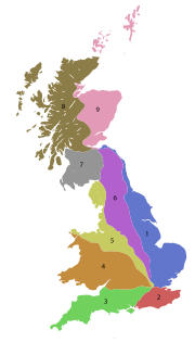
A roads in Zone 4 of the Great Britain numbering scheme
Encyclopedia
Great Britain
Great Britain or Britain is an island situated to the northwest of Continental Europe. It is the ninth largest island in the world, and the largest European island, as well as the largest of the British Isles...
starting north of the A4 and south/west of the A5 (roads beginning with 4).
Single- and double-digit roads
| Road | From | To | Notes |
|---|---|---|---|
| City of London City of London The City of London is a small area within Greater London, England. It is the historic core of London around which the modern conurbation grew and has held city status since time immemorial. The City’s boundaries have remained almost unchanged since the Middle Ages, and it is now only a tiny part of... (Holborn Circus Holborn Holborn is an area of Central London. Holborn is also the name of the area's principal east-west street, running as High Holborn from St Giles's High Street to Gray's Inn Road and then on to Holborn Viaduct... ) |
Avonmouth Avonmouth Avonmouth is a port and suburb of Bristol, England, located on the Severn Estuary, at the mouth of the River Avon.The council ward of Avonmouth also includes Shirehampton and the western end of Lawrence Weston.- Geography :... |
Originally London to Bath | |
| City of London City of London The City of London is a small area within Greater London, England. It is the historic core of London around which the modern conurbation grew and has held city status since time immemorial. The City’s boundaries have remained almost unchanged since the Middle Ages, and it is now only a tiny part of... (near St. Paul's Cathedral) |
Fishguard Fishguard Fishguard is a coastal town in Pembrokeshire, south-west Wales, with a population of 3,300 . The community of Fishguard and Goodwick had a population of 5043 at the 2001 census.... |
The longest A road in Zone 4 at 256 miles long | |
| Central London Central London Central London is the innermost part of London, England. There is no official or commonly accepted definition of its area, but its characteristics are understood to include a high density built environment, high land values, an elevated daytime population and a concentration of regionally,... (near Marble Arch Marble Arch Marble Arch is a white Carrara marble monument that now stands on a large traffic island at the junction of Oxford Street, Park Lane, and Edgware Road, almost directly opposite Speakers' Corner in Hyde Park in London, England... ) |
Birkenhead Birkenhead Birkenhead is a town within the Metropolitan Borough of Wirral in Merseyside, England. It is on the Wirral Peninsula, along the west bank of the River Mersey, opposite the city of Liverpool... |
||
| Appleby Magna Appleby Magna Appleby Magna is a village and civil parish in the district of North West Leicestershire, England.The civil parish, as well as Appleby Magna, includes the small Hamlet of Appleby Parva and the Villages of Norton-Juxta-Twycross, Snarestone and Swepstone... |
Diseworth Diseworth Diseworth is a village in the English county of Leicestershire. It is south of East Midlands Airport and off Junction 23A of the M1 motorway.A village of some 670 residents, it is located 14 km to the north-west of Loughborough and 2.5 km to the south-east of Castle Donington... |
A continuation of the M42, hence the use of A42 despite the road being entirely within Zone 5. | |
| M40 motorway M40 motorway The M40 motorway is a motorway in the British transport network that forms a major part of the connection between London and Birmingham. Part of this road forms a section of the unsigned European route E05... Junction 10 north of Bicester Bicester Bicester is a town and civil parish in the Cherwell district of northeastern Oxfordshire in England.This historic market centre is one of the fastest growing towns in Oxfordshire Development has been favoured by its proximity to junction 9 of the M40 motorway linking it to London, Birmingham and... |
Stamford Stamford, Lincolnshire Stamford is a town and civil parish within the South Kesteven district of the county of Lincolnshire, England. It is approximately to the north of London, on the east side of the A1 road to York and Edinburgh and on the River Welland... |
||
| Oxford Oxford The city of Oxford is the county town of Oxfordshire, England. The city, made prominent by its medieval university, has a population of just under 165,000, with 153,900 living within the district boundary. It lies about 50 miles north-west of London. The rivers Cherwell and Thames run through... |
Aberystwyth Aberystwyth Aberystwyth is a historic market town, administrative centre and holiday resort within Ceredigion, Wales. Often colloquially known as Aber, it is located at the confluence of the rivers Ystwyth and Rheidol.... |
Officially the most dangerous road in Wales Wales Wales is a country that is part of the United Kingdom and the island of Great Britain, bordered by England to its east and the Atlantic Ocean and Irish Sea to its west. It has a population of three million, and a total area of 20,779 km²... between Aberystwyth Aberystwyth Aberystwyth is a historic market town, administrative centre and holiday resort within Ceredigion, Wales. Often colloquially known as Aber, it is located at the confluence of the rivers Ystwyth and Rheidol.... and Llangurig Llangurig Llangurig is a village in Powys, within the historic county boundaries of Montgomeryshire, mid Wales, lying on the River Wye. The population is 670.Llangurig is reputed to be the highest village in Wales at an altitude of 1000 feet... . |
|
| Birmingham Birmingham Birmingham is a city and metropolitan borough in the West Midlands of England. It is the most populous British city outside the capital London, with a population of 1,036,900 , and lies at the heart of the West Midlands conurbation, the second most populous urban area in the United Kingdom with a... |
Near Thrapston Thrapston Thrapston is a small town in Northamptonshire, England. It is the headquarters of the East Northamptonshire district, and in 2001 had a population of 4,855. By 2006, this was estimated to be over 5,700.... |
||
| Bath | Cleethorpes Cleethorpes Cleethorpes is a town and unparished area in North East Lincolnshire, England, situated on the estuary of the Humber. It has a population of 31,853 and is a seaside resort.- History :... |
||
| Birmingham Birmingham Birmingham is a city and metropolitan borough in the West Midlands of England. It is the most populous British city outside the capital London, with a population of 1,036,900 , and lies at the heart of the West Midlands conurbation, the second most populous urban area in the United Kingdom with a... |
Great Yarmouth Great Yarmouth Great Yarmouth, often known to locals as Yarmouth, is a coastal town in Norfolk, England. It is at the mouth of the River Yare, east of Norwich.It has been a seaside resort since 1760, and is the gateway from the Norfolk Broads to the sea... |
||
| Highnam Highnam Highnam is a village and civil parish on the outskirts of the city of Gloucester. It is three miles northwest of the city on the A40, on its way to Ross, west of Alney Island and Over Bridge. The parish includes the villages of Lassington and Over... near Gloucester Gloucester Gloucester is a city, district and county town of Gloucestershire in the South West region of England. Gloucester lies close to the Welsh border, and on the River Severn, approximately north-east of Bristol, and south-southwest of Birmingham.... |
Carmarthen Carmarthen Carmarthen is a community in, and the county town of, Carmarthenshire, Wales. It is sited on the River Towy north of its mouth at Carmarthen Bay. In 2001, the population was 14,648.... |
Originally began in Worcester Worcester The City of Worcester, commonly known as Worcester, , is a city and county town of Worcestershire in the West Midlands of England. Worcester is situated some southwest of Birmingham and north of Gloucester, and has an approximate population of 94,000 people. The River Severn runs through the... . Worcester to Newport Newport Newport is a city and unitary authority area in Wales. Standing on the banks of the River Usk, it is located about east of Cardiff and is the largest urban area within the historic county boundaries of Monmouthshire and the preserved county of Gwent... is now A449. |
|
| Ross-on-Wye Ross-on-Wye Ross-on-Wye is a small market town with a population of 10,089 in southeastern Herefordshire, England, located on the River Wye, and on the northern edge of the Forest of Dean.-History:... |
Bamber Bridge Bamber Bridge Bamber Bridge is a village to the south of Preston, Lancashire, England. The name derives from the Old English 'bēam' and 'brycg', which probably means "tree-trunk bridge". It is mentioned in an undated medieval document. The village is often referred to as "Brig" by residents... |
Triple-digit roads
| Road | From | To | Notes |
|---|---|---|---|
| Central London Central London Central London is the innermost part of London, England. There is no official or commonly accepted definition of its area, but its characteristics are understood to include a high density built environment, high land values, an elevated daytime population and a concentration of regionally,... (Trafalgar Square Trafalgar Square Trafalgar Square is a public space and tourist attraction in central London, England, United Kingdom. At its centre is Nelson's Column, which is guarded by four lion statues at its base. There are a number of statues and sculptures in the square, with one plinth displaying changing pieces of... ) |
Archway | Takes the route of the Northern Line Northern Line The Northern line is a London Underground line. It is coloured black on the Tube map.For most of its length it is a deep-level tube line. The line carries 206,734,000 passengers per year. This is the highest number of any line on the London Underground system, but the Northern line is unique in... , Charing Cross Branch and Barnet Branch |
|
| 401 | Central London Central London Central London is the innermost part of London, England. There is no official or commonly accepted definition of its area, but its characteristics are understood to include a high density built environment, high land values, an elevated daytime population and a concentration of regionally,... (Piccadilly Circus Piccadilly Circus Piccadilly Circus is a road junction and public space of London's West End in the City of Westminster, built in 1819 to connect Regent Street with the major shopping street of Piccadilly... ) |
Angel The Angel, Islington Angel is a district of London, England, and part of the London Borough of Islington. The area is identified in the London Plan as one of 35 major centres in Greater London.-History:... |
Along Shaftesbury Avenue Shaftesbury Avenue Shaftesbury Avenue is a major street in central London, England, named after Anthony Ashley Cooper, 7th Earl of Shaftesbury, that runs in a north-easterly direction from Piccadilly Circus to New Oxford Street, crossing Charing Cross Road at Cambridge Circus.... , Bloomsbury Way, Theobald's Road, Rosebery Avenue and the northern most part of St John Street |
| Central London Central London Central London is the innermost part of London, England. There is no official or commonly accepted definition of its area, but its characteristics are understood to include a high density built environment, high land values, an elevated daytime population and a concentration of regionally,... (Marble Arch Marble Arch Marble Arch is a white Carrara marble monument that now stands on a large traffic island at the junction of Oxford Street, Park Lane, and Edgware Road, almost directly opposite Speakers' Corner in Hyde Park in London, England... ) |
Stamford Brook Stamford Brook Stamford Brook is a tributary of the River Thames which is the confluence of two smaller streams, arising in West London, flowing into Hammersmith Creek on the Tideway.... , Chiswick Chiswick Chiswick is a large suburb of west London, England and part of the London Borough of Hounslow. It is located on a meander of the River Thames, west of Charing Cross and is one of 35 major centres identified in the London Plan. It was historically an ancient parish in the county of Middlesex, with... |
Includes sections of the original A40 along Bayswater Road, Notting Hill Gate and Holland Park Avenue, the E/W carriageways of Shepherds Bush Green and Goldhawk Road | |
| M48 motorway M48 motorway The M48 is a motorway in Great Britain joining Gloucestershire and Monmouthshire over the original Severn Bridge. The M48 is anomalously numbered, as it is entirely to the west of the M5 motorway and its number should really therefore begin with 5.-Route:... Junction 1 near Aust Aust Aust is a small village in South Gloucestershire, England, the historical site of the eastern terminal of the Aust Ferry crossing route over the River Severn between England and Wales, believed to have been used in Roman times as a continuation of Icknield Street which led from Eastern England... |
Avonmouth Avonmouth Avonmouth is a port and suburb of Bristol, England, located on the Severn Estuary, at the mouth of the River Avon.The council ward of Avonmouth also includes Shirehampton and the western end of Lawrence Weston.- Geography :... |
||
| Central London Central London Central London is the innermost part of London, England. There is no official or commonly accepted definition of its area, but its characteristics are understood to include a high density built environment, high land values, an elevated daytime population and a concentration of regionally,... (Edgware Road station Edgware Road tube station (Bakerloo Line) Edgware Road is a London Underground station in the City of Westminster. It is served by the Bakerloo line and is between Paddington and Marylebone stations. It is in Travelcard Zone 1. The station is located on the north-east corner of the junction of Edgware Road, Harrow Road and Marylebone Road... ) |
Maidenhead Maidenhead Maidenhead is a town and unparished area within the Royal Borough of Windsor and Maidenhead, in Berkshire, England. It lies on the River Thames and is situated west of Charing Cross in London.-History:... |
The London section is called Harrow Road for most of its length. | |
| Leavesden Green | Near Park Street Park Street, Hertfordshire Park Street is a village on the outskirts of St Albans, Hertfordshire.-Location:Park Street is situated approximately 2½ miles south of St Albans along the Watling Street, the old Roman road from London to Chester and Holyhead. It lies south of the A405 North Orbital Road and on Watling Street... |
||
| Gunnersbury Gunnersbury Gunnersbury is a place in the London Borough of Hounslow, with its northern edge in the London Borough of Ealing, west London. It has an area of less than half a square kilometre and is within the west area of the Chiswick W4 postal district of London.... |
Beckton Beckton Beckton is part of the London Borough of Newham, England, located east of Charing Cross.Its boundaries are the A13 trunk road to the north, Barking Creek to the east, the Royal Docks to the south, and Prince Regent Lane to the west. The area around Prince Regent Lane is also known as Custom House... |
The North Circular Road | |
| Harlesden Harlesden Harlesden is an area in the London Borough of Brent, northwest London, UK. Its main focal point is the Jubilee Clock which commemorates Queen Victoria's Golden Jubilee.... |
Child's Hill | Through Willesden Willesden Willesden is an area in North West London which forms part of the London Borough of Brent. It is situated 5 miles north west of Charing Cross... including the High Road and Cricklewood Cricklewood Cricklewood is a district of North London, England whose northeastern part is in the London Borough of Barnet, western part is the London Borough of Brent and southeastern part is in London Borough of Camden.-History:... |
|
| Harmondsworth Harmondsworth Harmondsworth is a village in the London Borough of Hillingdon, close to London Heathrow Airport. The village is situated south of West Drayton.The nearest places are: Hayes, Harlington, Heathrow Airport, Longford, London, Sipson, West Drayton and Yiewsley.... |
Uxbridge Uxbridge Uxbridge is a large town located in north west London, England and is the administrative headquarters of the London Borough of Hillingdon. It forms part of the ceremonial county of Greater London. It is located west-northwest of Charing Cross and is one of the major metropolitan centres... |
The southern section in Sipson Sipson Sipson is a village in the London Borough of Hillingdon, in west London, England. It is situated west of Charing Cross and near the northern perimeter of London Heathrow Airport.-Toponymy:... due to be demolished to make way for Heathrow Airport 3rd runway |
|
| Northwick Park Hospital Northwick Park Hospital Northwick Park Hospital is a large hospital in the northwest corner of the London Borough of Brent in Greater London, England.-Hospital role:... |
Bushey Bushey Bushey is a town in the Hertsmere borough of Hertfordshire in the East of England. Bushey Heath is situated to the south east of Bushey on the boundary with the London Borough of Harrow.-History:... |
through the middle of Wealdstone and the western part of Stanmore known as Stanmore Common | |
| Pinner Pinner - Climate :Pinner's geographical position on the far western side of North West London makes it the furthest London suburb from any UK coastline. Hence the lower prevalence of moderating maritime influences make Pinner noticeably warmer in the spring and the summer compared to the rest of the capital... |
Edgware Edgware Edgware is an area in London, situated north-northwest of Charing Cross. It forms part of both the London Borough of Barnet and the London Borough of Harrow. The area is identified in the London Plan as one of 35 major centres in Greater London.... |
Uxbridge Road, through Stanmore Broadway, then London Road and Spur Road meeting the A41 | |
| Watford Watford Watford is a town and borough in Hertfordshire, England, situated northwest of central London and within the bounds of the M25 motorway. The borough is separated from Greater London to the south by the urbanised parish of Watford Rural in the Three Rivers District.Watford was created as an urban... |
Barnet Barnet High Barnet or Chipping Barnet is a place in the London Borough of Barnet, North London, England. It is a suburban development built around a twelfth-century settlement and is located north north-west of Charing Cross. Its name is often abbreviated to Barnet, which is also the name of the London... |
Meets the A41 twice between which it goes through the centre of Watford, Bushey Arches and Bushey Heath, then through the northern part of Elstree, across Stirling Corner through Arkley and into Barnet | |
| Slough Slough Slough is a borough and unitary authority within the ceremonial county of Royal Berkshire, England. The town straddles the A4 Bath Road and the Great Western Main Line, west of central London... |
Garston Garston, Hertfordshire Garston is a village in Hertfordshire, England, more or less contiguous with Watford and now, despite retaining a local identity, is effectively, a suburb... |
||
| Gerrards Cross Gerrards Cross Gerrards Cross is a village in Buckinghamshire, England. It is in the south of the county, near the border with Greater London, south of Chalfont St Peter. Gerrards Cross is also a civil parish within South Bucks district, which was known as the Beaconsfield district from 1974 to 1980... |
Towcester Towcester Towcester , the Roman town of Lactodorum, is a small town in south Northamptonshire, England.-Etymology:Towcester comes from the Old English Tófe-ceaster. Tófe refers to the River Tove; Bosworth and Toller compare it to the "Scandinavian proper names" Tófi and Tófa... |
||
| Near Hemel Hempstead Hemel Hempstead Hemel Hempstead is a town in Hertfordshire in the East of England, to the north west of London and part of the Greater London Urban Area. The population at the 2001 Census was 81,143 .... |
Maldon Maldon, Essex Maldon is a town on the Blackwater estuary in Essex, England. It is the seat of the Maldon district and starting point of the Chelmer and Blackwater Navigation.Maldon is twinned with the Dutch town of Cuijk... |
||
| Berinsfield Berinsfield Berinsfield is a village and civil parish in South Oxfordshire, about southeast of Oxford.-History:Palaeolithic and Roman artefacts were found during 20th century excavations to build the village. The Roman road between Dorchester-on-Thames and Alchester runs through the centre of Berinsfield... |
Witney Witney Witney is a town on the River Windrush, west of Oxford in Oxfordshire, England.The place-name 'Witney' is first attested in a Saxon charter of 969 as 'Wyttannige'; it appears as 'Witenie' in the Domesday Book of 1086. The name means 'Witta's island'.... |
||
| Amersham Amersham Amersham is a market town and civil parish within Chiltern district in Buckinghamshire, England, 27 miles north west of London, in the Chiltern Hills. It is part of the London commuter belt.... |
Berkhamsted Berkhamsted -Climate:Berkhamsted experiences an oceanic climate similar to almost all of the United Kingdom.-Castle:... |
||
| Streatley Streatley, Berkshire Streatley is a village and civil parish on the River Thames in Berkshire, England.-Location:Streatley is about from Reading and from Oxford. It is in the Goring Gap on the River Thames and is directly across the river from the Oxfordshire village of Goring-on-Thames... |
Leominster Leominster Leominster is a market town in Herefordshire, England, located approximately north of the city of Hereford and south of Ludlow, at... |
||
| M40 motorway M40 motorway The M40 motorway is a motorway in the British transport network that forms a major part of the connection between London and Birmingham. Part of this road forms a section of the unsigned European route E05... Junction 8a |
Ascott, Buckinghamshire Ascott, Buckinghamshire Ascott is a hamlet and country house in the parish of Wing, Buckinghamshire, England. The hamlet lies completely within the boundary of the Ascott Estate; it is home to many of the estate and house staff.... |
||
| Whitminster Whitminster Whitminster is a village in Gloucestershire, on the A38 trunk road about six miles south of Gloucester. It was formerly known as Wheatenhurst, the name being changed officially in 1945... |
Swindon Swindon Swindon is a large town within the borough of Swindon and ceremonial county of Wiltshire, in South West England. It is midway between Bristol, west and Reading, east. London is east... |
||
| Bristol Bristol Bristol is a city, unitary authority area and ceremonial county in South West England, with an estimated population of 433,100 for the unitary authority in 2009, and a surrounding Larger Urban Zone with an estimated 1,070,000 residents in 2007... |
Oxford Oxford The city of Oxford is the county town of Oxfordshire, England. The city, made prominent by its medieval university, has a population of just under 165,000, with 153,900 living within the district boundary. It lies about 50 miles north-west of London. The rivers Cherwell and Thames run through... |
||
| Croughton Croughton, Northamptonshire Croughton is a small village in the South Northamptonshire district of Northamptonshire, England. It is close to the border with Oxfordshire and Buckinghamshire and is six kilometres southwest of the town of Brackley... |
Wyboston Wyboston Wyboston is a village in the English county of Bedfordshire.The eastern part of the village is dominated by the A1 Great North Road which at this point also carries the traffic of the A428 east–west road. The northern junction of these roads is grade-separated, while the southern junction is a... |
||
| Bedford Bedford Bedford is the county town of Bedfordshire, in the East of England. It is a large town and the administrative centre for the wider Borough of Bedford. According to the former Bedfordshire County Council's estimates, the town had a population of 79,190 in mid 2005, with 19,720 in the adjacent town... |
Worcester Worcester The City of Worcester, commonly known as Worcester, , is a city and county town of Worcestershire in the West Midlands of England. Worcester is situated some southwest of Birmingham and north of Gloucester, and has an approximate population of 94,000 people. The River Severn runs through the... |
Concurrent with the A46 between Stratford-upon-Avon Stratford-upon-Avon Stratford-upon-Avon is a market town and civil parish in south Warwickshire, England. It lies on the River Avon, south east of Birmingham and south west of Warwick. It is the largest and most populous town of the District of Stratford-on-Avon, which uses the term "on" to indicate that it covers... and Alcester Alcester Alcester is an old market town of Roman origin at the junction of the River Alne and River Arrow in Warwickshire, England. It is situated approximately west of Stratford-upon-Avon, and 8 miles south of Redditch, close to the Worcestershire border... |
|
| Hinksey Hill Hinksey Hill Hinksey Hill is a hill and residential area south of the centre of Oxford. It is in South Hinksey civil parish, about south of the village. Hinksey Hill was part of Berkshire until the 1974 boundary changes transferred it to Oxfordshire.... |
Coventry Coventry Coventry is a city and metropolitan borough in the county of West Midlands in England. Coventry is the 9th largest city in England and the 11th largest in the United Kingdom. It is also the second largest city in the English Midlands, after Birmingham, with a population of 300,848, although... |
Small section of the road is part of the Oxford Ring Road Oxford Ring Road The Oxford ring road is a ring road around the city of Oxford, England. It is a dual carriageway for most of its length apart from a short section to the North between the Woodstock and Banbury Roads.... . Reprised at Banbury Banbury Banbury is a market town and civil parish on the River Cherwell in the Cherwell District of Oxfordshire. It is northwest of London, southeast of Birmingham, south of Coventry and north northwest of the county town of Oxford... . |
|
| Burford Burford Burford is a small town on the River Windrush in the Cotswold hills in west Oxfordshire, England, about west of Oxford, southeast of Cheltenham and only from the Gloucestershire boundary... |
A44 near Bourton-on-the-Hill Bourton-on-the-Hill Bourton-on-the-Hill is a village and civil parish in the Cotswold district of Gloucestershire, England, about two miles west of Moreton-in-Marsh. According to the 2001 Census it had a population of 309.... |
||
| Daventry Daventry Daventry is a market town in Northamptonshire, England, with a population of 22,367 .-Geography:The town is also the administrative centre of the larger Daventry district, which has a population of 71,838. The town is 77 miles north-northwest of London, 13.9 miles west of Northampton and 10.2... |
Warwick Warwick Warwick is the county town of Warwickshire, England. The town lies upon the River Avon, south of Coventry and just west of Leamington Spa and Whitnash with which it is conjoined. As of the 2001 United Kingdom census, it had a population of 23,350... |
||
| Leicester Leicester Leicester is a city and unitary authority in the East Midlands of England, and the county town of Leicestershire. The city lies on the River Soar and at the edge of the National Forest... |
Southam Southam Southam is a small market town in the Stratford-on-Avon district of Warwickshire, England. The 2001 census recorded a population of 6,509 in the town.The nearest sizeable town to Southam is Leamington Spa, located roughly 7 miles to the west... |
||
| Market Harborough Market Harborough Market Harborough is a market town within the Harborough district of Leicestershire, England.It has a population of 20,785 and is the administrative headquarters of Harborough District Council. It sits on the Northamptonshire-Leicestershire border... |
Oundle Oundle Oundle is an ancient market town on the River Nene in Northamptonshire, England, with a population of 5,345 or 5,674 . It lies some north of London and south-west of Peterborough... |
||
| Coventry Coventry Coventry is a city and metropolitan borough in the county of West Midlands in England. Coventry is the 9th largest city in England and the 11th largest in the United Kingdom. It is also the second largest city in the English Midlands, after Birmingham, with a population of 300,848, although... |
Cambridge Cambridge The city of Cambridge is a university town and the administrative centre of the county of Cambridgeshire, England. It lies in East Anglia about north of London. Cambridge is at the heart of the high-technology centre known as Silicon Fen – a play on Silicon Valley and the fens surrounding the... |
This road is now split in two parts between Great Barford Great Barford Great Barford is a village and civil parish in Bedfordshire, England, a few miles north-east of Bedford. It lies on the River Great Ouse at . It is twinned with Wöllstein, Germany... and Eaton Socon Eaton Socon Eaton Socon is a district of St Neots in Cambridgeshire, England. It was originally a village in Bedfordshire, along with the neighbouring village of Eaton Ford, but officially became part of the town in 1965... due to the extension of the A421 A421 road The A421 is an important road for east/west journeys across England. Together with the A428, the A43 and A34, it forms the route from Cambridge through Milton Keynes to Oxford... to the A1. |
|
| Chippenham Chippenham, Wiltshire Chippenham is a market town in Wiltshire, England, located east of Bath and west of London. In the 2001 census the population of the town was recorded as 28,065.... |
Coventry Coventry Coventry is a city and metropolitan borough in the county of West Midlands in England. Coventry is the 9th largest city in England and the 11th largest in the United Kingdom. It is also the second largest city in the English Midlands, after Birmingham, with a population of 300,848, although... |
||
| Quedgeley Quedgeley Quedgeley is a suburb and civil parish of Gloucester, England, situated southwest of the city. It is the only civil parish in Gloucester, and a has a population of 11,800.-See also:*RAF Quedgeley, a large RAF logistics site which closed in 1995... |
Longford, Gloucester Gloucester Gloucester is a city, district and county town of Gloucestershire in the South West region of England. Gloucester lies close to the Welsh border, and on the River Severn, approximately north-east of Bristol, and south-southwest of Birmingham.... |
||
| Bristol Bristol Bristol is a city, unitary authority area and ceremonial county in South West England, with an estimated population of 433,100 for the unitary authority in 2009, and a surrounding Larger Urban Zone with an estimated 1,070,000 residents in 2007... |
Bath | ||
| Bristol Bristol Bristol is a city, unitary authority area and ceremonial county in South West England, with an estimated population of 433,100 for the unitary authority in 2009, and a surrounding Larger Urban Zone with an estimated 1,070,000 residents in 2007... |
Old Sodbury Old Sodbury Old Sodbury is a small village in the valley of the River Frome just below and to the west of the Cotswold escarpment and to the east of Chipping Sodbury and Yate in South Gloucestershire, England. The village extends from Chipping Sodbury in the West to the Cotswold Edge in the East and is on the... |
||
| A46 at Dunkirk Dunkirk, Gloucestershire Dunkirk is a hamlet in the rural north of South Gloucestershire, near the Gloucestershire border, in the parish of Hawkesbury. The hamlet is on an important T-junction where the A46 meets the A433 .Dunkirk in Hawkesbury parish should not be confused with Dunkirk near Nailsworth, also on the A46... |
A429 A429 road The A429 is a main road in England that runs in a north-northeasterly direction from junction 17 of the M4 motorway to Coventry in the West Midlands, by way of Malmesbury, Cirencester, Stow-on-the-Wold, Moreton-in-Marsh, east of Stratford-upon-Avon, Warwick, and Kenilworth.For much of its length... SW of Cirencester Cirencester Cirencester is a market town in east Gloucestershire, England, 93 miles west northwest of London. Cirencester lies on the River Churn, a tributary of the River Thames, and is the largest town in the Cotswold District. It is the home of the Royal Agricultural College, the oldest agricultural... |
||
| Birmingham Birmingham Birmingham is a city and metropolitan borough in the West Midlands of England. It is the most populous British city outside the capital London, with a population of 1,036,900 , and lies at the heart of the West Midlands conurbation, the second most populous urban area in the United Kingdom with a... |
Cirencester Cirencester Cirencester is a market town in east Gloucestershire, England, 93 miles west northwest of London. Cirencester lies on the River Churn, a tributary of the River Thames, and is the largest town in the Cotswold District. It is the home of the Royal Agricultural College, the oldest agricultural... |
Concurrent with the A46 between Alcester Alcester Alcester is an old market town of Roman origin at the junction of the River Alne and River Arrow in Warwickshire, England. It is situated approximately west of Stratford-upon-Avon, and 8 miles south of Redditch, close to the Worcestershire border... and Teddington Hands |
|
| A417 A417 road -Streatley - Gloucester :It runs from Streatley at its junction with the A329 to Wantage, over the picturesque Berkshire Downs. In Wantage, it negotiates the market place -Streatley - Gloucester (M5):It runs from Streatley at its junction with the A329 (between Reading and Wallingford) to Wantage,... near Brockworth |
A44 near Salford, Oxfordshire Salford, Oxfordshire Salford is a village and civil parish about west of Chipping Norton, Oxfordshire.The Church of England parish church of Saint Mary was largely Norman until the Gothic Revival architect G.E. Street almost completely rebuilt it in 1854. The font and parts of two doorways are among the few Norman... |
||
| Harlington, London Harlington, London Harlington is a suburban area in the London Borough of Hillingdon, on the northern perimeter of London Heathrow Airport. It is situated west of Charing Cross.-Etymology:... |
A40 Western Avenue near Ickenham Ickenham Ickenham is a suburban area centred on an old village in Greater London, part of the London Borough of Hillingdon.While no major historical events have taken place in Ickenham, settlements dating back to the Roman occupation of Britain have been discovered during archaeological surveys, and the... |
Originally Gloucester Gloucester Gloucester is a city, district and county town of Gloucestershire in the South West region of England. Gloucester lies close to the Welsh border, and on the River Severn, approximately north-east of Bristol, and south-southwest of Birmingham.... to Newport Newport Newport is a city and unitary authority area in Wales. Standing on the banks of the River Usk, it is located about east of Cardiff and is the largest urban area within the historic county boundaries of Monmouthshire and the preserved county of Gwent... , now A48. |
|
| M5 motorway M5 motorway The M5 is a motorway in England. It runs from a junction with the M6 at West Bromwich near Birmingham to Exeter in Devon. Heading south-west, the M5 runs east of West Bromwich and west of Birmingham through Sandwell Valley... Junction 9 |
Llanfilo | ||
| Stratford-upon-Avon Stratford-upon-Avon Stratford-upon-Avon is a market town and civil parish in south Warwickshire, England. It lies on the River Avon, south east of Birmingham and south west of Warwick. It is the largest and most populous town of the District of Stratford-on-Avon, which uses the term "on" to indicate that it covers... |
A46 4 miles SW of Warwick Warwick Warwick is the county town of Warwickshire, England. The town lies upon the River Avon, south of Coventry and just west of Leamington Spa and Whitnash with which it is conjoined. As of the 2001 United Kingdom census, it had a population of 23,350... |
||
| Birmingham Birmingham Birmingham is a city and metropolitan borough in the West Midlands of England. It is the most populous British city outside the capital London, with a population of 1,036,900 , and lies at the heart of the West Midlands conurbation, the second most populous urban area in the United Kingdom with a... |
Cookhill Cookhill Cookhill is a village and civil parish in Worcestershire, England, on the county border near Alcester.-Politics:Cookhill is represented mainly by the Conservative Party and the Liberal Democrat Party, and is part of the South Redditch ward of Worcestershire County Council and as of January 2010 is... |
||
| Droitwich | Whitchurch Whitchurch, Shropshire Whitchurch is a market town in Shropshire, England on the border between England and Wales. It is the oldest continuously inhabited town in Shropshire. According to the 2001 Census, the population of the town is 8,673, with a more recent estimate putting the population of the town at 8,934... |
||
| Worcester Worcester The City of Worcester, commonly known as Worcester, , is a city and county town of Worcestershire in the West Midlands of England. Worcester is situated some southwest of Birmingham and north of Gloucester, and has an approximate population of 94,000 people. The River Severn runs through the... |
Newnham Bridge Newnham Bridge Newnham Bridge is a village in the parish of Knighton on Teme, near Tenbury Wells, Worcestershire, England, United Kingdom.The village derives part of its name from the bridge over the River Rea.-Location:... |
||
| Baginton Baginton Baginton is a village and civil parish in the Warwick district of Warwickshire, England, and has a common border with the City of Coventry of the West Midlands county. With a population of 801 , Baginton village is four miles south of Coventry city centre and seven miles north of... |
Burton upon Trent Burton upon Trent Burton upon Trent, also known as Burton-on-Trent or simply Burton, is a town straddling the River Trent in the east of Staffordshire, England. Its associated adjective is "Burtonian".... |
The original route between Coventry Coventry Coventry is a city and metropolitan borough in the county of West Midlands in England. Coventry is the 9th largest city in England and the 11th largest in the United Kingdom. It is also the second largest city in the English Midlands, after Birmingham, with a population of 300,848, although... and Nuneaton Nuneaton Nuneaton is the largest town in the Borough of Nuneaton and Bedworth and in the English county of Warwickshire.Nuneaton is most famous for its associations with the 19th century author George Eliot, who was born on a farm on the Arbury Estate just outside Nuneaton in 1819 and lived in the town for... was by-passed by dual carriageway in three phases over approximately 20 years leading up to 1995 |
|
| Warwick Warwick Warwick is the county town of Warwickshire, England. The town lies upon the River Avon, south of Coventry and just west of Leamington Spa and Whitnash with which it is conjoined. As of the 2001 United Kingdom census, it had a population of 23,350... |
A45 at Ryton-on-Dunsmore Ryton-on-Dunsmore Ryton-on-Dunsmore is a village and civil parish in the Rugby district of Warwickshire, and is south-east of Coventry, England. The 2001 census recorded a population of 1,672 in the parish. The A45 dual carriageway passes through the village.... |
||
| Little Packington Little Packington Little Packington is a hamlet in the North Warwickshire district of the county of Warwickshire in England. It is situated just to the north west of Great Packington and outside the boundaries of Packington Park.... |
Roughley Roughley Roughley is a part of Sutton Coldfield, which is in Birmingham in the West Midlands. It is north of Sutton Coldfield close to Mere Green and Four Oaks.- Transport :... |
||
| Hinckley Hinckley Hinckley is a town in southwest Leicestershire, England. It has a population of 43,246 . It is administered by Hinckley and Bosworth Borough Council... |
Coalville Coalville Coalville is a town in North West Leicestershire, England, with a population estimated in 2003 to be almost 33,000. It is situated on the A511 trunk road between Leicester and Burton upon Trent, close to junction 22 of the M1 motorway where the A511 meets the A50 between Ashby-de-la-Zouch and... |
The original route through Hinckley was by-passed by a new road completed in the early 1990s | |
| Kidderminster Kidderminster Kidderminster is a town, in the Wyre Forest district of Worcestershire, England. It is located approximately seventeen miles south-west of Birmingham city centre and approximately fifteen miles north of Worcester city centre. The 2001 census recorded a population of 55,182 in the town... |
Studley Studley Studley is a large village and civil parish in the Stratford-on-Avon district of Warwickshire, England. Situated on the western edge of Warwickshire near the border with Worcestershire it is southeast of Redditch and northwest of Stratford. The Roman road of Ryknild Street, now the A435, passes... |
The original route between Bromsgrove Bromsgrove Bromsgrove is a town in Worcestershire, England. The town is about north east of Worcester and south west of Birmingham city centre. It had a population of 29,237 in 2001 with a small ethnic minority and is in Bromsgrove District.- History :Bromsgrove is first documented in the early 9th century... and Redditch Redditch Redditch is a town and local government district in north-east Worcestershire, England, approximately south of Birmingham. The district had a population of 79,216 in 2005. In the 19th century it became the international centre for the needle and fishing tackle industry... was by-passed by a dual carriageway in the 1970s 1970s File:1970s decade montage.png|From left, clockwise: US President Richard Nixon doing the V for Victory sign after his resignation from office after the Watergate scandal in 1974; Refugees aboard a US naval boat after the Fall of Saigon, leading to the end of the Vietnam War in 1975; The 1973 oil... after Redditch was developed into a new town |
|
| Newport Newport Newport is a city and unitary authority area in Wales. Standing on the banks of the River Usk, it is located about east of Cardiff and is the largest urban area within the historic county boundaries of Monmouthshire and the preserved county of Gwent... |
Stafford Stafford Stafford is the county town of Staffordshire, in the West Midlands region of England. It lies approximately north of Wolverhampton and south of Stoke-on-Trent, adjacent to the M6 motorway Junction 13 to Junction 14... |
||
| Torton | West Hagley | ||
| Stourbridge Stourbridge Stourbridge is a town within the Metropolitan Borough of Dudley, in the West Midlands of England. Historically part of Worcestershire, Stourbridge was a centre of glass making, and today includes the suburbs of Amblecote, Lye, Norton, Oldswinford, Pedmore, Wollaston, Wollescote and Wordsley The... |
Great Witley Great Witley Great Witley is a village and civil parish in the Malvern Hills District in the northwest of the county of Worcestershire, England... |
||
| Leamington Spa Leamington Spa Royal Leamington Spa, commonly known as Leamington Spa or Leamington or Leam to locals, is a spa town in central Warwickshire, England. Formerly known as Leamington Priors, its expansion began following the popularisation of the medicinal qualities of its water by Dr Kerr in 1784, and by Dr Lambe... |
Brownhills Brownhills Brownhills is a town in the West Midlands, England. Located on the edge of Cannock Chase near the large artificial lake Chasewater, it is north-east of Walsall and a similar distance south-west of Lichfield. It is part of the Metropolitan Borough of Walsall and the Aldridge-Brownhills... |
||
| Nottingham Nottingham Nottingham is a city and unitary authority in the East Midlands of England. It is located in the ceremonial county of Nottinghamshire and represents one of eight members of the English Core Cities Group... |
Birmingham Birmingham Birmingham is a city and metropolitan borough in the West Midlands of England. It is the most populous British city outside the capital London, with a population of 1,036,900 , and lies at the heart of the West Midlands conurbation, the second most populous urban area in the United Kingdom with a... |
||
| Bridgnorth Bridgnorth Bridgnorth is a town in Shropshire, England, along the Severn Valley. It is split into Low Town and High Town, named on account of their elevations relative to the River Severn, which separates the upper town on the right bank from the lower on the left... |
Four Oaks | The section through Willenhall Willenhall Willenhall is a town in the Black Country area of the West Midlands of England, with a population of approximately 40,000. It is situated between Wolverhampton and Walsall, historically in the county of Staffordshire... was renumbered in the 1970s 1970s File:1970s decade montage.png|From left, clockwise: US President Richard Nixon doing the V for Victory sign after his resignation from office after the Watergate scandal in 1974; Refugees aboard a US naval boat after the Fall of Saigon, leading to the end of the Vietnam War in 1975; The 1973 oil... following the completion of The Keyway by-passing the south of the town, and further reumbering took place in 1995 on the completion of the Black Country Route Black Country Route The Black Country Route is a road in the West Midlands region of England.The plans for a motorway were drawn up in 1962 to ease congestion in the Black Country towns of Bilston and Willenhall, as well as giving the residents of Dudley, Coseley and Sedgley a more direct link with the M6 motorway... |
|
| Birmingham Birmingham Birmingham is a city and metropolitan borough in the West Midlands of England. It is the most populous British city outside the capital London, with a population of 1,036,900 , and lies at the heart of the West Midlands conurbation, the second most populous urban area in the United Kingdom with a... |
Woofferton Woofferton Woofferton is a village to the south of Ludlow, Shropshire, England. It is one of Shropshire's most southerly villages and lies on the border with Herefordshire. The public house there - the "Salwey Arms" - is the most southerly in the county... |
The section through Halesowen Halesowen Halesowen is a town in the Metropolitan Borough of Dudley, in the West Midlands, England.The population, as measured by the United Kingdom Census 2001, was 55,273... was renumbered when the by-pass opened in the 1960s 1960s The 1960s was the decade that started on January 1, 1960, and ended on December 31, 1969. It was the seventh decade of the 20th century.The 1960s term also refers to an era more often called The Sixties, denoting the complex of inter-related cultural and political trends across the globe... |
|
| Birmingham Birmingham Birmingham is a city and metropolitan borough in the West Midlands of England. It is the most populous British city outside the capital London, with a population of 1,036,900 , and lies at the heart of the West Midlands conurbation, the second most populous urban area in the United Kingdom with a... |
Sedgley Sedgley Sedgley is an urban village within the West Midlands county of England. Historically a part of Staffordshire, Sedgley was formerly an ancient manor composed of several smaller villages, including Gornal, Gospel End, Woodsetton, Ettingshall, Coseley and Brierley... |
The original route through Smethwick Smethwick Smethwick is a town in the Metropolitan Borough of Sandwell, in the West Midlands of England. It is situated on the edge of the city of Birmingham, within the historic boundaries of Staffordshire, Worcestershire and Warwickshire.... town centre was renumbered when a by-pass opened in about 1970 |
|
| Mallwyd Mallwyd Mallwyd is a small village at the most southern end of the county of Gwynedd in North Wales in the valley of the River Dyfi. It lies on the A470 approximately half-way between Dolgellau and Machynlleth, and forms the junction of the A458 towards Welshpool. The nearest village is Dinas Mawddwy, two... |
Quinton Quinton, Birmingham Quinton is a suburb on the western edge of Birmingham, England. It is a Birmingham City Council ward within the Edgbaston formal district, and forms a part of the Birmingham Edgbaston parliamentary constituency.The area is served by .-Geography:... |
Originally started in Dolgellau Dolgellau Dolgellau is a market town in Gwynedd, north-west Wales, lying on the River Wnion, a tributary of the River Mawddach. It was the county town of the former county of Merionethshire .-History and economy:... . Further renumberings have taken place over the years, notably when the town of Bridgnorth Bridgnorth Bridgnorth is a town in Shropshire, England, along the Severn Valley. It is split into Low Town and High Town, named on account of their elevations relative to the River Severn, which separates the upper town on the right bank from the lower on the left... was by-passed in 1985 |
|
| Halesowen Halesowen Halesowen is a town in the Metropolitan Borough of Dudley, in the West Midlands, England.The population, as measured by the United Kingdom Census 2001, was 55,273... |
Wolverhampton Wolverhampton Wolverhampton is a city and metropolitan borough in the West Midlands, England. For Eurostat purposes Walsall and Wolverhampton is a NUTS 3 region and is one of five boroughs or unitary districts that comprise the "West Midlands" NUTS 2 region... |
Renumbering took place when Dudley town centre was by-passed by a new route of the A461 in 1999. The road continued south of Halesowen towards Bromsgrove Bromsgrove Bromsgrove is a town in Worcestershire, England. The town is about north east of Worcester and south west of Birmingham city centre. It had a population of 29,237 in 2001 with a small ethnic minority and is in Bromsgrove District.- History :Bromsgrove is first documented in the early 9th century... until the 1970s 1970s File:1970s decade montage.png|From left, clockwise: US President Richard Nixon doing the V for Victory sign after his resignation from office after the Watergate scandal in 1974; Refugees aboard a US naval boat after the Fall of Saigon, leading to the end of the Vietnam War in 1975; The 1973 oil... . |
|
| Wolverhampton Wolverhampton Wolverhampton is a city and metropolitan borough in the West Midlands, England. For Eurostat purposes Walsall and Wolverhampton is a NUTS 3 region and is one of five boroughs or unitary districts that comprise the "West Midlands" NUTS 2 region... |
Rugeley Rugeley Rugeley is a historic market town in the county of Staffordshire, England. It lies on the northern edge of Cannock Chase, and is situated roughly midway between the towns of Stafford, Cannock, Lichfield and Uttoxeter... |
The section through the centre of Cannock Cannock Cannock is the most populous of three towns in the district of Cannock Chase in the central southern part of the county of Staffordshire in the West Midlands region of England.... was renumbered in 1989 when the town's by-pass opened. |
|
| Lichfield Lichfield Lichfield is a cathedral city, civil parish and district in Staffordshire, England. One of eight civil parishes with city status in England, Lichfield is situated roughly north of Birmingham... |
Stourbridge Stourbridge Stourbridge is a town within the Metropolitan Borough of Dudley, in the West Midlands of England. Historically part of Worcestershire, Stourbridge was a centre of glass making, and today includes the suburbs of Amblecote, Lye, Norton, Oldswinford, Pedmore, Wollaston, Wollescote and Wordsley The... |
Concurrent with the A41 between Wednesbury Wednesbury Wednesbury is a market town in England's Black Country, part of the Sandwell metropolitan borough in West Midlands, near the source of the River Tame. Similarly to the word Wednesday, it is pronounced .-Pre-Medieval and Medieval times:... & Great Bridge Great Bridge, West Midlands Great Bridge is a village in the Metropolitan Borough of Sandwell. It is situated in Tipton, near the border of West Bromwich, and it is within the metropolitan county of the West Midlands.-Origins and history:... |
|
| Wednesbury Wednesbury Wednesbury is a market town in England's Black Country, part of the Sandwell metropolitan borough in West Midlands, near the source of the River Tame. Similarly to the word Wednesday, it is pronounced .-Pre-Medieval and Medieval times:... |
Laney Green | The section through Darlaston Darlaston Darlaston is a town in the Metropolitan Borough of Walsall in the West Midlands of England.-History:Archaeological evidence of the history of Darlaston has been destroyed by The de Darlaston family owned Darlaston and lived in the manor between the 12th century and 15th century. When the de... town centre became unclassified when a new by-pass opened in the late 1960s 1960s The 1960s was the decade that started on January 1, 1960, and ended on December 31, 1969. It was the seventh decade of the 20th century.The 1960s term also refers to an era more often called The Sixties, denoting the complex of inter-related cultural and political trends across the globe... |
|
| Wombourne Wombourne Wombourne is a very large village and civil parish located in the district of South Staffordshire, in the county of Staffordshire, 4 miles south-west of Wolverhampton. Local affairs are run by a parish council. At the 2001 census it had a population of 13,691... |
Willenhall Willenhall Willenhall is a town in the Black Country area of the West Midlands of England, with a population of approximately 40,000. It is situated between Wolverhampton and Walsall, historically in the county of Staffordshire... |
The section beyond Coseley Coseley Coseley is a town located mostly within the Metropolitan Borough of Dudley in the English West Midlands. Part of the Black Country, it lies south east of Wolverhampton and north of Dudley.... was either renumbered or became unclassified when the Black Country Route Black Country Route The Black Country Route is a road in the West Midlands region of England.The plans for a motorway were drawn up in 1962 to ease congestion in the Black Country towns of Bilston and Willenhall, as well as giving the residents of Dudley, Coseley and Sedgley a more direct link with the M6 motorway... was completed between 1986 and 1995 |
|
| Oaken Oaken Oaken is a small village in Staffordshire, England. The first mention of the Oaken place-name, was in 1086 when it was listed in the Domesday book as Ache. Its origin appears to be from the Old English, ācum - the oaks.... |
Hollinswood | ||
| Bromyard Bromyard Bromyard is a town in northeast Herefordshire, England with a population of approximately 4,000. It lies near to the county border with Worcestershire on the A44 between Leominster and Worcester. Bromyard has a number of traditional half-timbered pubs and some buildings dating back to Norman times... |
M4 motorway M4 motorway The M4 motorway links London with South Wales. It is part of the unsigned European route E30. Other major places directly accessible from M4 junctions are Reading, Swindon, Bristol, Newport, Cardiff and Swansea... , Llandarcy Llandarcy Llandarcy is a village near Neath in Neath Port Talbot county borough, southwest Wales, and formerly the site of the UK's first oil refinery. The village, which lies near the Junction 43 of the M4 Motorway, was originally designed as a garden village to house the workers for the refinery, built by... |
||
| Kingsthorne | Chepstow Chepstow Chepstow is a town in Monmouthshire, Wales, adjoining the border with Gloucestershire, England. It is located on the River Wye, close to its confluence with the River Severn, and close to the western end of the Severn Bridge on the M48 motorway... |
||
| Duffryn Duffryn Duffryn is a large council housing housing estate in the southwest of the city of Newport, Wales comprising a large portion of the Tredegar Park electoral district . Built on land belonging to Tredegar House , it was completed in 1978 and at the time won several awards for its design... , Newport Newport Newport is a city and unitary authority area in Wales. Standing on the banks of the River Usk, it is located about east of Cardiff and is the largest urban area within the historic county boundaries of Monmouthshire and the preserved county of Gwent... |
A465 A465 road The A465 is a major road in south Wales. It is more commonly known as the Heads of the Valleys Road because it joins together the north ends of the South Wales Valleys... , Brynmawr Brynmawr Brynmawr is a market town in Blaenau Gwent, south Wales. The town, sometimes cited as the highest town in Wales, is situated at 1,250 to 1,500 feet above sea level and nestled at the head of the South Wales Valleys... |
||
| Bassaleg Bassaleg Bassaleg is a small semi-urban suburb on the west side of the city of Newport, in south Wales. It lies in the Graig electoral ward and community.- Location, communications & amenities:Bassaleg is located two miles north west of Newport city centre... , Newport Newport Newport is a city and unitary authority area in Wales. Standing on the banks of the River Usk, it is located about east of Cardiff and is the largest urban area within the historic county boundaries of Monmouthshire and the preserved county of Gwent... |
A470 A470 road The A470 is a major long-distance connective spine road in Wales, running from Cardiff on the south coast to Llandudno on the north coast. It covers approximately 186 miles , over a zig-zagging route through the entirety of the country's mountainous central region, including the Brecon Beacons and... , Nantgarw Nantgarw Nantgarw is a village in the county borough of Rhondda Cynon Taf, Wales, near Cardiff.From an electoral and administrative perspective Nantgarw falls within the ward of Taffs Well, a village some 2.5 miles south, but historically fell within the boundaries of Caerphilly, which is a major town... |
||
| A4161, Roath Roath Roath is a district in the east/north-east of the city of Cardiff, capital of Wales.It lies just east/north east of the city centre, stretching from Adamsdown in the south to Roath Park in the north. Roath contains the Plasnewydd electoral ward. The name is believed to originate from Irish ráth,... , Cardiff Cardiff Cardiff is the capital, largest city and most populous county of Wales and the 10th largest city in the United Kingdom. The city is Wales' chief commercial centre, the base for most national cultural and sporting institutions, the Welsh national media, and the seat of the National Assembly for... |
A465 A465 road The A465 is a major road in south Wales. It is more commonly known as the Heads of the Valleys Road because it joins together the north ends of the South Wales Valleys... , Rhymney Rhymney Rhymney is a town and a community located in the county borough of Caerphilly in south-east Wales, within the historic boundaries of Monmouthshire. Along with the villages of Pontlottyn, Fochriw, Abertysswg, Deri and New Tredegar, Rhymney is designated as the 'Upper Rhymney Valley' by the local... |
||
| Cardiff Cardiff Cardiff is the capital, largest city and most populous county of Wales and the 10th largest city in the United Kingdom. The city is Wales' chief commercial centre, the base for most national cultural and sporting institutions, the Welsh national media, and the seat of the National Assembly for... |
Llandudno Llandudno Llandudno is a seaside resort and town in Conwy County Borough, Wales. In the 2001 UK census it had a population of 20,090 including that of Penrhyn Bay and Penrhynside, which are within the Llandudno Community... |
Originally Cardiff to Brecon Brecon Brecon is a long-established market town and community in southern Powys, Mid Wales, with a population of 7,901. It was the county town of the historic county of Brecknockshire; although its role as such was eclipsed with the formation of Powys, it remains an important local centre... . |
|
| Treharris Treharris Treharris is a small town and community in the Taff Bargoed Valley in the south of the county borough of Merthyr Tydfil, South Wales. It is located around 1 km west of Trelewis, from which it is separated by the Taff Bargoed river, and 1.5 km from Nelson in Caerphilly county borough and... |
Usk Usk Usk is a small town in Monmouthshire, Wales, situated 10 miles northeast of Newport.The River Usk flows through the town and is spanned by an ancient, arched stone bridge at the western entrance to the town. A castle above the town overlooks the ancient Anglo-Welsh border crossing - the river can... |
||
| Pontypridd Pontypridd Pontypridd is both a community and a principal town of Rhondda Cynon Taf, Wales and is situated 12 miles/19 km north of the Welsh capital city of Cardiff... |
Bridgend Bridgend Bridgend is a town in the Bridgend County Borough in Wales, west of the capital, Cardiff. The river crossed by the original bridge, which gave the town its name, is the River Ogmore but the River Ewenny also passes to the south of the town... |
Originally started at Treforest but following the completion of the Church Village bypass it now starts at Upper Boat Upper Boat Upper Boat is a village on the southernmost outskirts of the town of Pontypridd, within the electoral ward of Hawthorn, Rhondda Cynon Taf, Wales, and comprises part of the Treforest Industrial Estate. Historically it fell within the parish of Eglwysilan, Mid Glamorgan... and the section between Treforest and Gwaun Meisgyn is now downgraded to the B4595. |
|
| Briton Ferry Briton Ferry Briton Ferry is a town and community in the county borough of Neath Port Talbot, Wales. The town encompasses the electoral wards of Briton Ferry East and Briton Ferry West.... |
Ammanford | ||
| Newcastle Emlyn Newcastle Emlyn Newcastle Emlyn is a town straddling the counties of Ceredigion and Carmarthenshire in west Wales and lying on the River Teifi.Adpar is the part of the town that lies on the Ceredigion side of the River Teifi... |
Lampeter Lampeter Lampeter is a town in Ceredigion, South West Wales, lying at the confluence of the River Teifi and the Afon Dulas.-Demographics:At the 2001 National Census, the population was 2894. Lampeter is therefore the smallest university town in both Wales and the United Kingdom... |
||
| Llanelli Llanelli Llanelli , the largest town in both the county of Carmarthenshire and the preserved county of Dyfed , Wales, sits on the Loughor estuary on the West Wales coast, approximately west-north-west of Swansea and south-east of the county town, Carmarthen. The town is famous for its proud rugby... |
Llandeilo Llandeilo Llandeilo is a town in Carmarthenshire, Wales, situated at the crossing of the River Towy by the A483 on a 19th century stone bridge. Its population is 1,731.The town is served by Llandeilo railway station on the Heart of Wales Line.- Early history :... |
||
| St Clears St Clears St Clears is a small town on the River Tâf in Carmarthenshire, Wales. According to the 2001 UK census, it has a population of 2,820 people, most of whom are Welsh-speaking, although there is a marked difference between the southern and northern ends of the town in percentage terms.-History:The... |
Johnston Johnston, Pembrokeshire Johnston is a community in the hundred of Roose, Pembrokeshire, Wales.It lies on the A4076 road approximately midway between Haverfordwest and the port of Milford Haven and is served by Johnston railway station. Until the end of the 19th century, anthracite was mined here... |
||
| Cardigan Cardigan, Ceredigion Cardigan is a town in the county of Ceredigion in Mid Wales. It lies on the estuary of the River Teifi at the point where Ceredigion meets Pembrokeshire. It was the county town of the pre-1974 county of Cardiganshire. It is the second largest town in Ceredigion. The town's population was 4,203... |
Tenby Tenby Tenby is a walled seaside town in Pembrokeshire, South West Wales, lying on Carmarthen Bay.Notable features of Tenby include of sandy beaches; the 13th century medieval town walls, including the Five Arches barbican gatehouse ; 15th century St... |
||
| Glanusk | Llyswen Llyswen Llyswen is a small village in Powys, Wales on the west bank of the River Wye. It was formerly within the county of Brecknockshire and now forms part of the Community of Bronllys... |
Runs through the heart of the Brecon Beacons in Wales. Some maps incorrectly indicate another A479 running through Empire Way, Wembley (North West of London) but this actually is the B4565 | |
| A44 A44 road The A44 is a major road in the United Kingdom that runs from Oxford in southern England to Aberystwyth in west Wales.-History:The original route of the A44 was Chipping Norton to Aberystwyth. No changes were made to the route of the A44 in the early years... at Lyonshall Lyonshall Lyonshall is a historic village and civil parish in Herefordshire, England. According to the 2001 census it had a population of 750.- Location :... |
A438 west of Hereford Hereford Hereford is a cathedral city, civil parish and county town of Herefordshire, England. It lies on the River Wye, approximately east of the border with Wales, southwest of Worcester, and northwest of Gloucester... |
||
| Aberaeron Aberaeron Aberaeron |Aeron]] being a Welsh god of war) is a seaside resort town in Ceredigion, Wales. Situated between Aberystwyth and Cardigan, it is home to the headquarters of Ceredigion County Council. The population was 1520 in 2001.-History and design:... |
Llanwrda Llanwrda Llanwrda is a parish and a village on the River Towy, in the county of Carmarthenshire, west Wales, 3½ miles from Llandovery, in the U.K... |
||
| Swansea Swansea Swansea is a coastal city and county in Wales. Swansea is in the historic county boundaries of Glamorgan. Situated on the sandy South West Wales coast, the county area includes the Gower Peninsula and the Lliw uplands... |
Chester Chester Chester is a city in Cheshire, England. Lying on the River Dee, close to the border with Wales, it is home to 77,040 inhabitants, and is the largest and most populous settlement of the wider unitary authority area of Cheshire West and Chester, which had a population of 328,100 according to the... |
||
| Cardigan Cardigan, Ceredigion Cardigan is a town in the county of Ceredigion in Mid Wales. It lies on the estuary of the River Teifi at the point where Ceredigion meets Pembrokeshire. It was the county town of the pre-1974 county of Cardiganshire. It is the second largest town in Ceredigion. The town's population was 4,203... |
Cadle Cadle Cadle is a village in the City and County of Swansea, Wales near Fforestfach. It now forms part of the built-up area in and around Fforestfach.... near Swansea Swansea Swansea is a coastal city and county in Wales. Swansea is in the historic county boundaries of Glamorgan. Situated on the sandy South West Wales coast, the county area includes the Gower Peninsula and the Lliw uplands... |
by way of Newcastle Emlyn Newcastle Emlyn Newcastle Emlyn is a town straddling the counties of Ceredigion and Carmarthenshire in west Wales and lying on the River Teifi.Adpar is the part of the town that lies on the Ceredigion side of the River Teifi... , Carmarthen Carmarthen Carmarthen is a community in, and the county town of, Carmarthenshire, Wales. It is sited on the River Towy north of its mouth at Carmarthen Bay. In 2001, the population was 14,648.... and Llanelli Llanelli Llanelli , the largest town in both the county of Carmarthenshire and the preserved county of Dyfed , Wales, sits on the Loughor estuary on the West Wales coast, approximately west-north-west of Swansea and south-east of the county town, Carmarthen. The town is famous for its proud rugby... |
|
| Tanerdy | Llanfarian Llanfarian Llanfarian is a village located in the district county of Ceredigion, Mid-Wales, south of the administrative centre Aberystwyth.The 2001 census showed Llanfarian as having a population of 1442.... |
||
| New Quay New Quay New Quay is a seaside town in Ceredigion, West Wales with a resident population of around 1,200 people. Located on Cardigan Bay with a harbour and large sandy beaches, it remains a popular seaside resort and traditional fishing town.-History:... |
A484 A484 road The A484 road is an A road in Wales connecting Swansea with Cardigan.The road begins at Cadle in Swansea and heads westwards as a southern bypass to Loughor. It continues over the Loughor bridge into Bynea, Carmarthenshire. It continues through the centre of Llanelli and traverses near the south... near Saron Saron, Carmarthenshire Saron is a mining village near the town of Ammanford in Carmarthenshire, Wales.... |
||
| Haverfordwest Haverfordwest Haverfordwest is the county town of Pembrokeshire, Wales and serves as the County's principal commercial and administrative centre. Haverfordwest is the most populous urban area in Pembrokeshire, with a population of 13,367 in 2001; though its community boundaries make it the second most populous... |
Bangor Bangor, Gwynedd Bangor is a city in Gwynedd, north west Wales, and one of the smallest cities in Britain. It is a university city with a population of 13,725 at the 2001 census, not including around 10,000 students at Bangor University. Including nearby Menai Bridge on Anglesey, which does not however form part of... |
||
| Penybont Penybont Penybont is a small village in Powys, Wales.- Location :It is located to the east of Crossgates, and to the north-east of Llandrindod Wells. The A44 runs east-west through the village, and the A488, which starts in Penybont, runs north to Knighton and Shrewsbury... |
Shrewsbury Shrewsbury Shrewsbury is the county town of Shropshire, in the West Midlands region of England. Lying on the River Severn, it is a civil parish home to some 70,000 inhabitants, and is the primary settlement and headquarters of Shropshire Council... |
||
| Craven Arms Craven Arms Craven Arms is a small town and civil parish in Shropshire, England, located on the A49 road and the Welsh Marches railway line, which connect it north and south to the larger towns of Shrewsbury and Ludlow respectively. The Heart of Wales railway line joins the Welsh Marches line at Craven Arms... |
Machynlleth Machynlleth Machynlleth is a market town in Powys, Wales. It is in the Dyfi Valley at the intersection of the A487 and the A489 roads.Machynlleth was the seat of Owain Glyndŵr's Welsh Parliament in 1404, and as such claims to be the "ancient capital of Wales". However, it has never held any official... |
||
| Churchstoke | Llanfyllin Llanfyllin Llanfyllin is a small town in Powys, Mid Wales, United Kingdom.- Location, history and amenities :Llanfyllin's population at the date of the 2001 Census was 1,407. The town lies on the River Cain by the Berwyn Mountains in Montgomeryshire. It is known for its holy well, dedicated to Saint Myllin.... |
||
| Lydiate Ash Lydiate Ash Lydiate Ash is a hamlet, consisting of a few houses and the road gritting depot for Bromsgrove District Council.area of North Worcestershire, England. It is in the district of Bromsgrove, to the south-west of Birmingham.... |
Wall Heath Wall Heath -Geography:Wall Heath is a small village on the western fringe of the Black Country and the West Midlands conurbation in the United Kingdom. It is located on the A449 road, approximately seven miles south of Wolverhampton and 9 miles North of Kidderminster.... |
||
| Machynlleth Machynlleth Machynlleth is a market town in Powys, Wales. It is in the Dyfi Valley at the intersection of the A487 and the A489 roads.Machynlleth was the seat of Owain Glyndŵr's Welsh Parliament in 1404, and as such claims to be the "ancient capital of Wales". However, it has never held any official... |
Dolgellau Dolgellau Dolgellau is a market town in Gwynedd, north-west Wales, lying on the River Wnion, a tributary of the River Mawddach. It was the county town of the former county of Merionethshire .-History and economy:... |
Via Tywyn Tywyn Tywyn is a town and seaside resort on the Cardigan Bay coast of southern Gwynedd , in north Wales. The name derives from the Welsh tywyn and the town is sometimes referred to as Tywyn Meirionnydd... |
|
| Queensferry Queensferry, Flintshire Queensferry is a town in Flintshire, North Wales, lying on the River Dee near the border with England.Queensferry lies along the B5441 and B5129 roads, and is bypassed by the A494 dual carriageway. It is contiguous with Deeside... |
Dolgellau Dolgellau Dolgellau is a market town in Gwynedd, north-west Wales, lying on the River Wnion, a tributary of the River Mawddach. It was the county town of the former county of Merionethshire .-History and economy:... |
Extension to M56 motorway M56 motorway The M56 Motorway, also known as the North Cheshire motorway, is in Cheshire and Greater Manchester, England. It runs from Junction 4 of the M60 to Dunkirk, Cheshire and is in length. It is often busy with long-distance commuter traffic towards North Wales... opened late 2008. |
|
| Whitchurch Whitchurch, Shropshire Whitchurch is a market town in Shropshire, England on the border between England and Wales. It is the oldest continuously inhabited town in Shropshire. According to the 2001 Census, the population of the town is 8,673, with a more recent estimate putting the population of the town at 8,934... |
The A458 near Llanfair Caereinion | By-passes Oswestry Oswestry Oswestry is a town and civil parish in Shropshire, England, close to the Welsh border. It is at the junction of the A5, A483, and A495 roads.... as part of the A483 |
|
| Llanelltyd Llanelltyd Llanelltyd is a small village and community in Gwynedd, to the north of Dolgellau.It is home to the 12th-century Cymer Abbey and one of the oldest parish churches in Wales.- External links :*... |
Blaenau Ffestiniog Blaenau Ffestiniog Blaenau Ffestiniog is a town in Gwynedd, north-west Wales. It has a population of 5,000, including Llan Ffestiniog, which makes it the third largest town in Gwynedd, behind Caernarfon & Porthmadog. Although the population reached 12,000 at the peak of the slate industry, the population fell due to... |
Via Barmouth Barmouth Barmouth ; Y Bermo ) is a town in the county of Gwynedd, north-western Wales, lying on the estuary of the River Mawddach and Cardigan Bay.The town is served by Barmouth railway station.- History :... |
|
| Porthmadog Porthmadog Porthmadog , known locally as "Port", and historically rendered into English as Portmadoc, is a small coastal town and community in the Eifionydd area of Gwynedd, in Wales. Prior to the Local Government Act 1972 it was in the administrative county of Caernarfonshire. The town lies east of... |
Nefyn Nefyn Nefyn is a small town and community on the north west coast of the Llŷn Peninsula in Gwynedd, Wales, with a population of 2,619. Welsh is the first language of almost 80% of its inhabitants. The A497 road terminates in the town centre.-History:... |
||
| Pen-y-Gwryd Pen-y-Gwryd Pen-y-Gwryd is a pass at the head of Nantygwryd and Nant Cynnyd rivers in Gwynedd, North Wales and a quarter of a mile from the boundary with Conwy in northern Snowdonia, close to the foot of Snowdon... |
Porthmadog Porthmadog Porthmadog , known locally as "Port", and historically rendered into English as Portmadoc, is a small coastal town and community in the Eifionydd area of Gwynedd, in Wales. Prior to the Local Government Act 1972 it was in the administrative county of Caernarfonshire. The town lies east of... |
||
| A487 A487 road The A487 is a trunk road in Wales, running up the western side of the country from Haverfordwest in the south to Bangor in the north.It starts at Merlin's Bridge near Haverfordwest, from where it travels north west to St David's, then switches back north east through Fishguard, Cardigan, Aberaeron,... |
Abersoch Abersoch Abersoch is a large village in the community of Llanengan in Gwynedd, Wales. It is a popular coastal seaside resort with approximately 1,000 inhabitants, on the east-facing south coast of the Llŷn Peninsula at the southern terminus of the A499. It is about south-west of Pwllheli and south-west of... |
Four-digit roads (40xx)
| Road | From | To | Notes |
|---|---|---|---|
| Acton Town | Harlesden Harlesden Harlesden is an area in the London Borough of Brent, northwest London, UK. Its main focal point is the Jubilee Clock which commemorates Queen Victoria's Golden Jubilee.... |
||
| Hanwell Hanwell Hanwell is a town situated in the London Borough of Ealing in west London, between Ealing and Southall. The motto of Hanwell Urban District Council was Nec Aspera Terrent... |
Hanwell | ||
| Harlesden Harlesden Harlesden is an area in the London Borough of Brent, northwest London, UK. Its main focal point is the Jubilee Clock which commemorates Queen Victoria's Golden Jubilee.... |
Harlesden | Tubbs Road / Nightingale Road one-way system | |
| Brondesbury Brondesbury Brondesbury is an area of Kilburn in London, England. It is shared between the boroughs of Brent and Camden.-Nearest places:* Kilburn* Willesden* Kensal Green* Cricklewood-Nearest tube stations:* Kilburn * West Hampstead... |
Willesden Willesden Willesden is an area in North West London which forms part of the London Borough of Brent. It is situated 5 miles north west of Charing Cross... |
Willesden Lane | |
| Harlesden Harlesden Harlesden is an area in the London Borough of Brent, northwest London, UK. Its main focal point is the Jubilee Clock which commemorates Queen Victoria's Golden Jubilee.... |
Harlesden | ||
| West London West (London sub region) The West is a sub-region of the London Plan corresponding to the London Boroughs of Brent, Ealing, Hammersmith and Fulham, Harrow, Hillingdon and Hounslow. The sub region was established in 2004 and was adjusted in 2008 to include Kensington and Chelsea. The west has a population of 1.6 million and... (Hanger Lane gyratory) |
Roxeth Roxeth Roxeth was a hamlet in the ancient Harrow on the Hill parish, which now forms part of the London Borough of Harrow in Greater London, England.The ancient parish of Harrow on the Hill, or simply Harrow, was one of the largest parishes in Middlesex... |
||
| Harrow Harrow, London Harrow is an area in the London Borough of Harrow, northwest London, United Kingdom. It is a suburban area and is situated 12.2 miles northwest of Charing Cross... |
West Hendon West Hendon West Hendon is a place in the London Borough of Barnet.-History:West Hendon was a settlement within that part of the ancient parish of Hendon known as the Hyde, and is now a part of the London Borough of Barnet. It was formally known, from 1878–1890, as New Hendon, a small railway development on... |
Also known as Kenton Road Kenton Road Kenton Road is a main road in the London Borough of Harrow and the London Borough of Brent. It lies in the areas of Harrow and Kenton. Its eastern end is the border of Kenton in Middlesex and Kingsbury in London. Kenton Road is the A4006, apart from a short stretch west of Northwick Park... and Kingsbury Road |
|
| Iver Heath | Uxbridge Uxbridge Uxbridge is a large town located in north west London, England and is the administrative headquarters of the London Borough of Hillingdon. It forms part of the ceremonial county of Greater London. It is located west-northwest of Charing Cross and is one of the major metropolitan centres... |
||
| Hatch End Hatch End Hatch End is a place in the London Borough of Harrow, located north west of Charing Cross in Central London. The suburb is part of the Pinner post town.-Attractions:... |
Watford Watford Watford is a town and borough in Hertfordshire, England, situated northwest of central London and within the bounds of the M25 motorway. The borough is separated from Greater London to the south by the urbanised parish of Watford Rural in the Three Rivers District.Watford was created as an urban... |
||
| High Wycombe High Wycombe High Wycombe , commonly known as Wycombe and formally called Chepping Wycombe or Chipping Wycombe until 1946,is a large town in Buckinghamshire, England. It is west-north-west of Charing Cross in London; this figure is engraved on the Corn Market building in the centre of the town... |
Aylesbury Aylesbury Aylesbury is the county town of Buckinghamshire in South East England. However the town also falls into a geographical region known as the South Midlands an area that ecompasses the north of the South East, and the southern extremities of the East Midlands... |
||
| Husborne Crawley | A4146 A4146 road The A4146 is an A-class road running through south-central England from M1 Junction 14 at Milton Keynes, around Linslade and Leighton Buzzard , and via Dagnall to Hemel Hempstead, where it terminates at a roundabout with the A4251.In Milton Keynes, the road briefly follows the H6 Childs Way from... |
||
| Kingsditch | Benhall Benhall Benhall is a village and civil parish in the Suffolk Coastal district of Suffolk, England. Located to the south of Saxmundham, in 2007 its population was estimated to be 560.... |
||
| Pershore Pershore Pershore is a market town in Worcestershire, England, on the banks of the River Avon. Pershore is in the Wychavon district and is part of the West Worcestershire parliamentary constituency. At the 2001 census the population was 7,304... |
A449 A449 road The A449 is a major road in the United Kingdom. It runs north from junction 24 of the M4 motorway at Newport in South Wales to Stafford in Staffordshire.... near Little Malvern Little Malvern Little Malvern is a small village and a civil parish on the lower slopes of the Malvern Hills south of Malvern Wells, near Great Malvern, the major centre of the area often referred to as The Malverns. in Worcestershire, England. It contains a Romanesque church called Little Malvern Priory, after... |
||
| Cheltenham Cheltenham Cheltenham , also known as Cheltenham Spa, is a large spa town and borough in Gloucestershire, on the edge of the Cotswolds in the South-West region of England. It is the home of the flagship race of British steeplechase horse racing, the Gold Cup, the main event of the Cheltenham Festival held... |
Cheltenham | ||
| Kingswood Kingswood, South Gloucestershire Kingswood is an urban area in South Gloucestershire, England, bordering the City of Bristol to the west. It is located on both sides of the A420 road, which connects Bristol and Chippenham and which forms the high street through the principal retail zone... |
A4174 A4174 road The A4174 is a major road in England which runs around the northern and eastern edge of Bristol, mainly in South Gloucestershire, and through the southern suburbs of Bristol... at Bromley Heath |
Soundwell Road | |
| Bristol Bristol Bristol is a city, unitary authority area and ceremonial county in South West England, with an estimated population of 433,100 for the unitary authority in 2009, and a surrounding Larger Urban Zone with an estimated 1,070,000 residents in 2007... |
Cribbs Causeway Cribbs Causeway Cribbs Causeway is a road in South Gloucestershire, England, just north of Bristol, which has given its name to a large out-of-town shopping centre, including retail parks and an enclosed shopping centre known as The Mall... |
||
| Coombe Hill Coombe Hill, Gloucestershire Coombe Hill is the name of a hamlet, telephone exchange and the terminus of the disused Coombe Hill Canal, now a nature reserve, in Gloucestershire, England.... |
Cheltenham Cheltenham Cheltenham , also known as Cheltenham Spa, is a large spa town and borough in Gloucestershire, on the edge of the Cotswolds in the South-West region of England. It is the home of the flagship race of British steeplechase horse racing, the Gold Cup, the main event of the Cheltenham Festival held... |
||
| Shepherds Bush | Denham Denham, Buckinghamshire Denham is a village and civil parish in the South Buckinghamshire district of Buckinghamshire, England. It is north west of Uxbridge and north of junction 1 of the M40 motorway. Denham contains the Buckinghamshire Golf Club.-Origin:... |
Known as the Uxbridge Road Uxbridge Road Uxbridge Road is the name of the A4020 road in London. It starts at Shepherd's Bush Green and goes west towards Uxbridge. It passes through Acton, Ealing Broadway and Hanwell.... for most of its length (with short stretches known by other names). |
|
| Redditch Redditch Redditch is a town and local government district in north-east Worcestershire, England, approximately south of Birmingham. The district had a population of 79,216 in 2005. In the 19th century it became the international centre for the needle and fishing tackle industry... |
Matchborough | Used to run from Redditch to Coventry but nearly all the section has been downgraded to the B4101 upon completion of the M42 M42 motorway The M42 motorway is a major road in England. The motorway runs north east from Bromsgrove in Worcestershire to just south west of Ashby-de-la-Zouch in Leicestershire, passing Redditch, Solihull, the National Exhibition Centre and Tamworth on the way. The section between the M40 and M6 road forms... in 1986. |
|
| Stourport-on-Severn Stourport-on-Severn Stourport-on-Severn, often shortened to Stourport, is a town and civil parish in the Wyre Forest District of North Worcestershire, England, a few miles to the south of Kidderminster and down stream on the River Severn from Bewdley... |
A449 A449 road The A449 is a major road in the United Kingdom. It runs north from junction 24 of the M4 motorway at Newport in South Wales to Stafford in Staffordshire.... |
||
| Sutton Coldfield Sutton Coldfield Sutton Coldfield is a suburb of Birmingham, in the West Midlands of England. Sutton is located about from central Birmingham but has borders with Erdington and Kingstanding. Sutton is in the northeast of Birmingham, with a population of 105,000 recorded in the 2001 census... |
Little Aston Little Aston Little Aston is an affluent area of the district of Lichfield, in Staffordshire, England. At the last UK census there were 935 homes in the village, well over 10% of which were multi-million pound properties... |
||
| Edgbaston Edgbaston Edgbaston is an area in the city of Birmingham in England. It is also a formal district, managed by its own district committee. The constituency includes the smaller Edgbaston ward and the wards of Bartley Green, Harborne and Quinton.... |
Edgbaston | Pebble Mill Road, dual carriageway, formerly home to the BBC BBC The British Broadcasting Corporation is a British public service broadcaster. Its headquarters is at Broadcasting House in the City of Westminster, London. It is the largest broadcaster in the world, with about 23,000 staff... Pebble Mill Studios Pebble Mill Studios The BBC 's Pebble Mill Studios were located in Edgbaston, a suburb of Birmingham, England. The views from the roof overlooked Cannon Hill Park, a nature centre, as well as Birmingham's city centre... . |
|
| Bearwood | Smethwick Smethwick Smethwick is a town in the Metropolitan Borough of Sandwell, in the West Midlands of England. It is situated on the edge of the city of Birmingham, within the historic boundaries of Staffordshire, Worcestershire and Warwickshire.... |
||
| Smethwick Smethwick Smethwick is a town in the Metropolitan Borough of Sandwell, in the West Midlands of England. It is situated on the edge of the city of Birmingham, within the historic boundaries of Staffordshire, Worcestershire and Warwickshire.... |
Walsall Walsall Walsall is a large industrial town in the West Midlands of England. It is located northwest of Birmingham and east of Wolverhampton. Historically a part of Staffordshire, Walsall is a component area of the West Midlands conurbation and part of the Black Country.Walsall is the administrative... |
||
| Bristol Bristol Bristol is a city, unitary authority area and ceremonial county in South West England, with an estimated population of 433,100 for the unitary authority in 2009, and a surrounding Larger Urban Zone with an estimated 1,070,000 residents in 2007... |
Bristol | Continuation of M32 motorway M32 motorway The M32 is a motorway in South Gloucestershire and Bristol, England. It provides a link from Bristol city centre to the M4 and is part of the Bristol Parkway. At about , it is one of Britain's shortest motorways... to A4044 inner ring road |
|
| Dudley Dudley Dudley is a large town in the West Midlands county of England. At the 2001 census , the Dudley Urban Sub Area had a population of 194,919, making it the 26th largest settlement in England, the second largest town in the United Kingdom behind Reading, and the largest settlement in the UK without... |
Oldbury Oldbury, West Midlands Oldbury is a town in the West Midlands in England. It is a part of the Black Country and the administrative centre of the borough of Sandwell.-Local government:... |
||
| Quinton Quinton, Birmingham Quinton is a suburb on the western edge of Birmingham, England. It is a Birmingham City Council ward within the Edgbaston formal district, and forms a part of the Birmingham Edgbaston parliamentary constituency.The area is served by .-Geography:... |
West Bromwich West Bromwich West Bromwich is a town within the Metropolitan Borough of Sandwell, in the West Midlands, England. It is north west of Birmingham lying on the A41 London-to-Birkenhead road. West Bromwich is part of the Black Country... |
||
| Dudley Dudley Dudley is a large town in the West Midlands county of England. At the 2001 census , the Dudley Urban Sub Area had a population of 194,919, making it the 26th largest settlement in England, the second largest town in the United Kingdom behind Reading, and the largest settlement in the UK without... |
Pedmore Pedmore Pedmore is a residential suburb of Stourbridge in the West Midlands of England. It was originally a village in the Worcestershire countryside until extensive housebuilding during the interwar years saw it gradually merged into Stourbridge.- Amenities :... |
||
| Wednesbury Wednesbury Wednesbury is a market town in England's Black Country, part of the Sandwell metropolitan borough in West Midlands, near the source of the River Tame. Similarly to the word Wednesday, it is pronounced .-Pre-Medieval and Medieval times:... |
Dudley Dudley Dudley is a large town in the West Midlands county of England. At the 2001 census , the Dudley Urban Sub Area had a population of 194,919, making it the 26th largest settlement in England, the second largest town in the United Kingdom behind Reading, and the largest settlement in the UK without... |
||
| Walsall Walsall Walsall is a large industrial town in the West Midlands of England. It is located northwest of Birmingham and east of Wolverhampton. Historically a part of Staffordshire, Walsall is a component area of the West Midlands conurbation and part of the Black Country.Walsall is the administrative... |
Moxley Moxley Moxley is a part of Darlaston in the West Midlands. It was first developed during the early part of the 19th century when a handful of terraced houses were built to accommodate locals working in factories and mines and the area was created in 1845 out of land from Darlaston, Bilston and... |
||
| Bilston Bilston Bilston is a town in the English county of West Midlands, situated in the southeastern corner of the City of Wolverhampton. Three wards of Wolverhampton City Council cover the town: Bilston East and Bilston North, which almost entirely comprise parts of the historic Borough of Bilston, and... |
Penn, West Midlands Penn, West Midlands Penn is an area now divided between Wolverhampton in the West Midlands and South Staffordshire. Originally, it was a village in the historic county of Staffordshire. There is considerable confusion about exactly which areas fall within Penn... |
||
| Birmingham Outer ring road | |||
| West Bromwich West Bromwich West Bromwich is a town within the Metropolitan Borough of Sandwell, in the West Midlands, England. It is north west of Birmingham lying on the A41 London-to-Birkenhead road. West Bromwich is part of the Black Country... |
Streetly Streetly Streetly is an area which lies mainly in the Metropolitan Borough of Walsall, England around 8 miles to the north of Birmingham. Streetly lies on the border of Birmingham and Walsall and is part of the West Midlands conurbation. It is adjacent to Aldridge, Sutton Coldfield, Great Barr and Four... |
||
| Abergavenny Abergavenny Abergavenny , meaning Mouth of the River Gavenny, is a market town in Monmouthshire, Wales. It is located 15 miles west of Monmouth on the A40 and A465 roads, 6 miles from the English border. Originally the site of a Roman fort, Gobannium, it became a medieval walled town within the Welsh Marches... |
A48, Newport Newport Newport is a city and unitary authority area in Wales. Standing on the banks of the River Usk, it is located about east of Cardiff and is the largest urban area within the historic county boundaries of Monmouthshire and the preserved county of Gwent... |
||
| Blaenavon Blaenavon Blaenavon is a town and World Heritage Site in south eastern Wales, lying at the source of the Afon Lwyd north of Pontypool, within the historic boundaries of Monmouthshire. The town lies high on a hillside and has a population of 6,349 people... B4246 |
Pontypool Pontypool Pontypool is a town of approximately 36,000 people in the county borough of Torfaen, within the historic boundaries of Monmouthshire in South Wales.... , A472 |
||
| Redcliffe, Bristol Redcliffe, Bristol Redcliffe, also known as Redcliff, is a district of the English port city of Bristol, adjoining the city centre. It is bounded by the loop of the Floating Harbour to the west, north and east, the New Cut of the River Avon to the south... |
St James Barton, Bristol Bristol Bristol is a city, unitary authority area and ceremonial county in South West England, with an estimated population of 433,100 for the unitary authority in 2009, and a surrounding Larger Urban Zone with an estimated 1,070,000 residents in 2007... |
Inner ring road: Redcliffe Way, Temple Way, Bond Street | |
| A465 A465 road The A465 is a major road in south Wales. It is more commonly known as the Heads of the Valleys Road because it joins together the north ends of the South Wales Valleys... , Rassau |
A467, Aberbeeg | ||
| A4048, Tredegar | A465 A465 road The A465 is a major road in south Wales. It is more commonly known as the Heads of the Valleys Road because it joins together the north ends of the South Wales Valleys... , Brynmawr |
||
| A467, Crosskeys | A465 A465 road The A465 is a major road in south Wales. It is more commonly known as the Heads of the Valleys Road because it joins together the north ends of the South Wales Valleys... , Tredegar |
||
| A4048, Pontllanfraith | A469 A469 road The A469 is a road in south Wales. It links Cardiff and Caerphilly with Rhymney and the Heads of the Valleys Road .-References:* Cardiff & Newport A-Z Street Atlas 2007 Edition... , New Tredegar |
||
| A4232 A4232 road The A4232, which is also known either as the Peripheral Distributor Road or the Cardiff Link Road , is a distributor road in Cardiff, the capital of Wales.... , Culverhouse Cross, Cardiff |
A4055 A4055 road The A4055 is the main road link between Cardiff Bay and Barry.The road goes through the village of Dinas Powys and there has been a call for by-pass due to the volume of traffic from Barry to and from Cardiff... , Barry |
||
| Newport Newport Newport is a city and unitary authority area in Wales. Standing on the banks of the River Usk, it is located about east of Cardiff and is the largest urban area within the historic county boundaries of Monmouthshire and the preserved county of Gwent... |
North Cwmbran Cwmbran Cwmbrân is a new town in Wales. Today forming part of the county borough of Torfaen and lying within the historic boundaries of Monmouthshire, Cwmbrân was established in 1949 to provide new employment opportunities in the south eastern portion of the South Wales Coalfield. Cwmbrân means Crow... |
||
| Coventry Coventry Coventry is a city and metropolitan borough in the county of West Midlands in England. Coventry is the 9th largest city in England and the 11th largest in the United Kingdom. It is also the second largest city in the English Midlands, after Birmingham, with a population of 300,848, although... Ring Road |
|||
| A4119 A4119 road The A4119 is an A road linking Tonypandy with Cardiff in south Wales.Settlements served by the route include:*Tonypandy*Penygraig*Williamstown*Tonyrefail*Ynysmaerdy*Talbot Green*Llantrisant*Groes-faen*Creigiau*Llandaff*Canton*Riverside*Grangetown... , Llandaff, Cardiff |
A470 A470 road The A470 is a major long-distance connective spine road in Wales, running from Cardiff on the south coast to Llandudno on the north coast. It covers approximately 186 miles , over a zig-zagging route through the entirety of the country's mountainous central region, including the Brecon Beacons and... , Cefn-Coed-y-Cymmer |
||
| A4232 A4232 road The A4232, which is also known either as the Peripheral Distributor Road or the Cardiff Link Road , is a distributor road in Cardiff, the capital of Wales.... , Cardiff Bay Cardiff Bay Cardiff Bay is the area created by the Cardiff Barrage in South Cardiff, the capital of Wales. The regeneration of Cardiff Bay is now widely regarded as one of the most successful regeneration projects in the United Kingdom. The Bay is supplied by two rivers to form a freshwater lake round the... , Cardiff |
Barry Island Barry Island Barry Island may refer to:*Barry Island , Wales*Barry Island , Antarctica... , Barry |
||
| A470 A470 road The A470 is a major long-distance connective spine road in Wales, running from Cardiff on the south coast to Llandudno on the north coast. It covers approximately 186 miles , over a zig-zagging route through the entirety of the country's mountainous central region, including the Brecon Beacons and... , Pontypridd |
A4061 A4061 road The A4061 is a main road linking Bridgend with Hirwaun in Wales.Settlements served by this road include:*Bridgend*Sarn*Bryncethin*Blackmill*Lewistown*Ogmore Vale*Price Town*Nantymoel*Treorchy*Treherbert*Hirwaun-Links:*... , Treorchy |
Originally started at Glyntaff but the sections between Glyntaff, Treforest and Pontypridd was downgraded to the B4595 following the completion of the Church Village bypass. This road originally ran through the village of Trealaw Trealaw Trealaw is the longest village in the Rhondda Valley, Rhondda Cynon Taf, Wales.Trealaw stretches over two miles from the junction of Cemetery Road and Brithweunydd Road in the east, to the junction of Ynyscynon Road and Partridge Road to the northwest.... but following the completion of the Porth Relief road the section between Porth Porth Porth is a town and a community in the county borough of Rhondda Cynon Taf, within the historic county boundaries of Glamorgan, Wales, lying in the Rhondda Valley and is regarded as the gateway to the Rhondda Fawr and Rhondda Fach valleys because both valleys meet at Porth... and Llwynypia Llwynypia Llwynypia , is a village in Rhondda Cynon Taf, Wales, near Tonypandy in the Rhondda Fawr Valley. Before 1850 a lightly populated rural farming area, Llwynypia experienced a population boom between 1860 and 1920 with the sinking of several coal mines after the discovery of large coal deposits... was downgraded to the B4278 and the road now runs through the village of Dinas Dinas Rhondda Dinas is a village near Tonypandy in the county borough of Rhondda Cynon Taf, Wales. Dinas is often referred to as Dinas Rhondda as in the railway station such as to avoid confusion with Dinas Powys in the Vale of Glamorgan... where the B4278 originally ran and also the former part of the A4119 near Llwynypia. |
|
| A470 A470 road The A470 is a major long-distance connective spine road in Wales, running from Cardiff on the south coast to Llandudno on the north coast. It covers approximately 186 miles , over a zig-zagging route through the entirety of the country's mountainous central region, including the Brecon Beacons and... , Abercynon |
A470 A470 road The A470 is a major long-distance connective spine road in Wales, running from Cardiff on the south coast to Llandudno on the north coast. It covers approximately 186 miles , over a zig-zagging route through the entirety of the country's mountainous central region, including the Brecon Beacons and... , Between Brecon and Cefn-Coed-y-Cymmer |
||
| A470 A470 road The A470 is a major long-distance connective spine road in Wales, running from Cardiff on the south coast to Llandudno on the north coast. It covers approximately 186 miles , over a zig-zagging route through the entirety of the country's mountainous central region, including the Brecon Beacons and... , Pentrebach |
A465 A465 road The A465 is a major road in south Wales. It is more commonly known as the Heads of the Valleys Road because it joins together the north ends of the South Wales Valleys... , Dowlais Top |
||
| Bridgend Bridgend Bridgend is a town in the Bridgend County Borough in Wales, west of the capital, Cardiff. The river crossed by the original bridge, which gave the town its name, is the River Ogmore but the River Ewenny also passes to the south of the town... |
Hirwaun Hirwaun Hirwaun is the name of a village at the northwest end of the Cynon Valley in the County Borough of Rhondda Cynon Taf, South Wales. The village of Hirwaun is from the town of Aberdare, and comes under Aberdare for postal reasons... |
||
| Bridgend Bridgend Bridgend is a town in the Bridgend County Borough in Wales, west of the capital, Cardiff. The river crossed by the original bridge, which gave the town its name, is the River Ogmore but the River Ewenny also passes to the south of the town... |
Cymer | ||
| Sam | Blaengarw Blaengarw Blaengarw is the uppermost village in the river valley of the River Garw, in the county borough of Bridgend, Wales.-External links:* *... |
||
| Tondu Tondu Tondu is a village in Bridgend County Borough, Wales, located about north of the town of Bridgend.Tondu lies on the A4063 from Bridgend to Maesteg, and was established in the late 18th century as a coal mining village servicing the Parc Slip Colliery... |
Brynmenyn Brynmenyn Brynmenyn is a small village located at the confluence of the Garw and Ogmore rivers in south Wales, around 4 miles north of Bridgend, and it also in the Bridgend County Borough council area. The village has its own primary school.-Transport:... |
||
| St Clears St Clears St Clears is a small town on the River Tâf in Carmarthenshire, Wales. According to the 2001 UK census, it has a population of 2,820 people, most of whom are Welsh-speaking, although there is a marked difference between the southern and northern ends of the town in percentage terms.-History:The... |
Pendine Pendine Pendine is a village in Carmarthenshire, Wales, United Kingdom lying on Carmarthen Bay.- History :The village consists of two parts: the old hill-top settlement around the parish church, and the small harbour settlement on the shore. The latter developed into a small seaside resort during the... |
||
| West Cross West Cross West Cross is a suburban area of Swansea, Wales, located to the south of Swansea city centre, near Mumbles falling within the West Cross ward.... , Swansea Swansea Swansea is a coastal city and county in Wales. Swansea is in the historic county boundaries of Glamorgan. Situated on the sandy South West Wales coast, the county area includes the Gower Peninsula and the Lliw uplands... |
Sennybridge Sennybridge Sennybridge is a village in Powys, Mid Wales, situated some from Cardiff and from Swansea. It lies west of Brecon on the A40 trunk road to Llandovery, at the point where the River Senni flows into the Usk... |
||
| Gurnos Gurnos Gurnos is a community of Merthyr Tydfil in Wales, United Kingdom. It consists principally of the Gurnos Estate, a large housing estate established by Merthyr Tydfil Council in the early 1950s and expanded over many years... |
Brynamman Brynamman Brynamman is a village sitting on the south facing side of the Black Mountain, part of the Brecon Beacons National Park. The village is split in two into Upper Brynamman and Lower Brynamman by the River Amman which also acts as the boundary between the counties of Carmarthenshire and Neath Port... |
||
| Llandovery Llandovery Llandovery is a market town in Carmarthenshire, Wales, lying on the River Tywi and the A40 road.The town is served by Llandovery railway station, where there is a park and ride to Llanelli and Shrewsbury via the Heart of Wales Line... |
Gwaun-Cae-Gurwen Gwaun-Cae-Gurwen Gwaun-Cae-Gurwen is a village in Neath Port Talbot, south Wales. Gwaun-Cae-Gurwen is also a parish made up of the electoral wards of Gwaun-Cae-Gurwen and Lower Brynamman.-Location:... |
||
| Dunsmore Heath | Rugby Rugby, Warwickshire Rugby is a market town in Warwickshire, England, located on the River Avon. The town has a population of 61,988 making it the second largest town in the county... |
||
| Iffley Iffley Iffley is a village in Oxfordshire, England, within the boundaries of the city of Oxford, between Cowley and the estates of Rose Hill and Donnington, and in proximity to the River Thames . Its most notable feature is its original and largely unchanged Norman church, St Mary the Virgin, which has a... |
Caversham Caversham, Berkshire Caversham is a suburb and former village in the unitary authority of Reading, England. It lies on the north bank of the River Thames, within the royal county of Berkshire, on the opposite bank from the rest of Reading... |
Links Reading Reading, Berkshire Reading is a large town and unitary authority area in England. It is located in the Thames Valley at the confluence of the River Thames and River Kennet, and on both the Great Western Main Line railway and the M4 motorway, some west of London.... with Oxford Oxford The city of Oxford is the county town of Oxfordshire, England. The city, made prominent by its medieval university, has a population of just under 165,000, with 153,900 living within the district boundary. It lies about 50 miles north-west of London. The rivers Cherwell and Thames run through... |
|
| Canaston Bridge Canaston Bridge Canaston Bridge is a village in Pembrokeshire, southwest Wales. It is on the edge of the Pembrokeshire Coast National Park, northeast of Pembroke.... |
Pembroke Pembroke, Pembrokeshire Pembroke is an historic settlement and former county town of Pembrokeshire in west Wales. The town and the county derive their name from that of the cantref of Penfro: Pen = "head" or "end", and bro = "region", "country", "land", and so it means essentially "Land's End".-History:The main point of... |
||
| Haverfordwest Haverfordwest Haverfordwest is the county town of Pembrokeshire, Wales and serves as the County's principal commercial and administrative centre. Haverfordwest is the most populous urban area in Pembrokeshire, with a population of 13,367 in 2001; though its community boundaries make it the second most populous... |
Milford Haven Milford Haven Milford Haven is a town and community in Pembrokeshire, Wales. It is situated on the north side of the Milford Haven Waterway, a natural harbour used as a port since the Middle Ages. The town was founded in 1790 on the north side of the Waterway, from which it takes its name... |
||
| Crickhowell Crickhowell Crickhowell is a small town in Powys, Mid Wales.-Location:The name Crickhowell is taken from that of the nearby Iron Age hill fort of Crug Hywel above the town, the Welsh language name being anglicised by map-makers and local English-speaking people... |
Gilwern & Goviton | ||
| Talgarth Talgarth Talgarth is a small market town and community in southern Powys , Mid Wales, with a population of 1,645. Notable buildings in the town include its 14th-century parish church and 13th century Pele Tower, located in the town centre, now home to the Tourist Information and Resource Centre... |
Three Cocks | ||
| Three Cocks | Llyswen Llyswen Llyswen is a small village in Powys, Wales on the west bank of the River Wye. It was formerly within the county of Brecknockshire and now forms part of the Community of Bronllys... |
||
| Menai Bridge Menai Bridge Menai Bridge is a small town and community on the Isle of Anglesey in north Wales. It overlooks the Menai Strait and lies by the Menai Suspension Bridge, built in 1826 by Thomas Telford... |
A55 A55 road The A55, also known as the North Wales Expressway, is a major road in Britain. Its entire length is a dual carriageway primary route, with the exception of the point where it crosses the Britannia Bridge over the Menai Strait. All junctions are grade separated except for two roundabouts — one... |
||
| Llandrindod Wells Llandrindod Wells Llandrindod Wells , colloquially known locally as "Llandod", is a town and community in Powys, within the historic boundaries of Radnorshire, mid Wales, United Kingdom. It was developed as a spa town in the 19th century, with a boom in the late 20th century as a centre of local government. Before... |
Newbridge-on-Wye Newbridge-on-Wye Newbridge-on-Wye is a small village in Powys, Wales. It lies, as its name suggests, on the River Wye, just downstream from the market town of Rhayader.- Location :... |
||
| Whitley, Coventry Whitley, Coventry Whitley is a suburb of southern Coventry in the West Midlands of England.-Industry and commerce:Whitley is the home of the Whitley plant, which is the Engineering Centre and Headquarters of Jaguar Cars Limited... |
Binley, Coventry Binley, Coventry Binley is a suburb in the east of Coventry, England. Binley evolved from a small mining village on the outskirts of Coventry to a large residential area composing private residences and council-owned properties.... |
Allard Way | |
| Minffordd Minffordd Minffordd is a village within the Welsh county of Gwynedd. It is situated on the A487 road between Porthmadog and Penrhyndeudraeth.... |
Caernarfon Caernarfon Caernarfon is a Royal town, community and port in Gwynedd, Wales, with a population of 9,611. It lies along the A487 road, on the east banks of the Menai Straits, opposite the Isle of Anglesey. The city of Bangor is to the northeast, while Snowdonia fringes Caernarfon to the east and southeast... |
||
| Capel Curig Capel Curig Capel Curig is a village and community in Conwy County Borough, in Wales. It lies in the heart of Snowdonia, on the River Llugwy, and has a population of 226... |
Caernarfon Caernarfon Caernarfon is a Royal town, community and port in Gwynedd, Wales, with a population of 9,611. It lies along the A487 road, on the east banks of the Menai Straits, opposite the Isle of Anglesey. The city of Bangor is to the northeast, while Snowdonia fringes Caernarfon to the east and southeast... |
||
| Bangor Bangor, Gwynedd Bangor is a city in Gwynedd, north west Wales, and one of the smallest cities in Britain. It is a university city with a population of 13,725 at the 2001 census, not including around 10,000 students at Bangor University. Including nearby Menai Bridge on Anglesey, which does not however form part of... |
Bangor | ||
| Willesden Willesden Willesden is an area in North West London which forms part of the London Borough of Brent. It is situated 5 miles north west of Charing Cross... |
Sudbury, London Sudbury, London Sudbury is a suburb in the London Boroughs of Brent and Harrow, located in northwest London, UK.Sudbury is an historical area having once extended from the 'South Manor- Sudbury' to the area that is now known as Wembley Central... |
||
| Alperton | Wembley Park Wembley Park Wembley Park is an area of northwest London, UK. It is part of Wembley, and located in the London Borough of Brent. It includes Wembley Stadium, England's primary football stadium and a major sports and entertainment venue, and Wembley Arena, a concert venue... |
||
| Wembley Wembley Wembley is an area of northwest London, England, and part of the London Borough of Brent. It is home to the famous Wembley Stadium and Wembley Arena... |
North Harrow North Harrow North Harrow is a residential area of North West Outer London. Despite its name, it is actually to the north-west of central Harrow. It has grown outwards from the North Harrow tube station which is on the Metropolitan Line which runs from Aldgate to Watford. It is one stop away from Harrow town... |
||
| Tamworth Tamworth Tamworth is a town and local government district in Staffordshire, England, located north-east of Birmingham city centre and north-west of London. The town takes its name from the River Tame, which flows through the town, as does the River Anker... |
Wishaw Wishaw Wishaw is a large town and former burgh in North Lanarkshire, Scotland. It is on the edge of the Clyde Valley, 15 miles south-east of Glasgow.... |
||
| Tonyrefail Tonyrefail Tonyrefail is a village and community in Rhondda Cynon Taf County Borough, Wales. It is situated north west of Llantrisant at the head of the Ely Valley, south of the Rhondda, being around from Trebanog and around from Williamstown. It is also around from the village of Gilfach Goch... |
Llangeinor Llangeinor Llangeinor is a small village located in the Garw Valley around 5 miles north of Bridgend in Bridgend County Borough, Wales. The entire village is now protected as part of a conservation area.-Transport:... |
||
| Rhondda Rhondda Rhondda , or the Rhondda Valley , is a former coal mining valley in Wales, formerly a local government district, consisting of 16 communities built around the River Rhondda. The valley is made up of two valleys, the larger Rhondda Fawr valley and the smaller Rhondda Fach valley... |
Llangeinor Llangeinor Llangeinor is a small village located in the Garw Valley around 5 miles north of Bridgend in Bridgend County Borough, Wales. The entire village is now protected as part of a conservation area.-Transport:... |
||
| Loudwater | Maidenhead Maidenhead Maidenhead is a town and unparished area within the Royal Borough of Windsor and Maidenhead, in Berkshire, England. It lies on the River Thames and is situated west of Charing Cross in London.-History:... |
||
| Faringdon Faringdon Faringdon is a market town in the Vale of White Horse, Oxfordshire, England. It is on the edge of the Thames Valley, between the River Thames and the Ridgeway... |
Bicester Bicester Bicester is a town and civil parish in the Cherwell district of northeastern Oxfordshire in England.This historic market centre is one of the fastest growing towns in Oxfordshire Development has been favoured by its proximity to junction 9 of the M40 motorway linking it to London, Birmingham and... |
Bladon Air Accident occurred near the A4095. | |
| Minworth Minworth Minworth is a village on the outskirts of Birmingham in the West Midlands area of England. It is located near Walmley, Wishaw, Warwickshire, Curdworth, Thimble End and Castle Vale.... |
Kingsbury Kingsbury Kingsbury is an area in the London Borough of Brent, northwest London. The name Kingsbury means "The King's Manor".-History:Kingsbury was historically a small parish in the Hundred of Gore and county of Middlesex. Until the nineteenth century it was largely rural with only scattered settlements.... |
||
| Moxley Moxley Moxley is a part of Darlaston in the West Midlands. It was first developed during the early part of the 19th century when a handful of terraced houses were built to accommodate locals working in factories and mines and the area was created in 1845 out of land from Darlaston, Bilston and... |
Wednesbury Wednesbury Wednesbury is a market town in England's Black Country, part of the Sandwell metropolitan borough in West Midlands, near the source of the River Tame. Similarly to the word Wednesday, it is pronounced .-Pre-Medieval and Medieval times:... |
||
| Halesowen Halesowen Halesowen is a town in the Metropolitan Borough of Dudley, in the West Midlands, England.The population, as measured by the United Kingdom Census 2001, was 55,273... |
Blackheath Blackheath, West Midlands Blackheath is a town in the Metropolitan Borough of Sandwell, West Midlands, England.-Establishment:Before 1841, Bleak Heath or Blake Heath was a small group of farm houses and inns on the turnpike road from Oldbury to Halesowen, within Rowley Regis... |
Four-digit roads (41xx)
| Road | From | To | Notes |
|---|---|---|---|
| Blackheath Blackheath, West Midlands Blackheath is a town in the Metropolitan Borough of Sandwell, West Midlands, England.-Establishment:Before 1841, Bleak Heath or Blake Heath was a small group of farm houses and inns on the turnpike road from Oldbury to Halesowen, within Rowley Regis... |
Brierley Hill Brierley Hill Brierley Hill is a town and electoral ward of the Metropolitan Borough of Dudley, West Midlands, England. It is one of the larger Black Country towns with a population of 9,631 and is heavily industrialised, best known for glass and steel manufacturing, although the industry has declined... |
||
| Kingswinford Kingswinford Kingswinford is a suburban area in the West Midlands.Historically within Staffordshire, the area is mentioned in the Domesday Book its name relates to a ford for the King's swine - Latin Swinford Regis. The current significance is probably in tourism, education and housing... |
Dudley Dudley Dudley is a large town in the West Midlands county of England. At the 2001 census , the Dudley Urban Sub Area had a population of 194,919, making it the 26th largest settlement in England, the second largest town in the United Kingdom behind Reading, and the largest settlement in the UK without... |
||
| Amblecote Amblecote Amblecote is an urban village in the Metropolitan Borough of Dudley in the West Midlands, England. It lies immediately north of the historic town of Stourbridge, extending about one and a half miles from it. As such, it is on the southwestern edge of the West Midlands urban area... |
Duplicate number | ||
| Merthyr Tydfil Merthyr Tydfil Merthyr Tydfil is a town in Wales, with a population of about 30,000. Although once the largest town in Wales, it is now ranked as the 15th largest urban area in Wales. It also gives its name to a county borough, which has a population of around 55,000. It is located in the historic county of... |
Merthyr Tydfil | ||
| Worcester Worcester The City of Worcester, commonly known as Worcester, , is a city and county town of Worcestershire in the West Midlands of England. Worcester is situated some southwest of Birmingham and north of Gloucester, and has an approximate population of 94,000 people. The River Severn runs through the... |
Hereford Hereford Hereford is a cathedral city, civil parish and county town of Herefordshire, England. It lies on the River Wye, approximately east of the border with Wales, southwest of Worcester, and northwest of Gloucester... |
||
| Little Malvern Little Malvern Little Malvern is a small village and a civil parish on the lower slopes of the Malvern Hills south of Malvern Wells, near Great Malvern, the major centre of the area often referred to as The Malverns. in Worcestershire, England. It contains a Romanesque church called Little Malvern Priory, after... |
Pershore Pershore Pershore is a market town in Worcestershire, England, on the banks of the River Avon. Pershore is in the Wychavon district and is part of the West Worcestershire parliamentary constituency. At the 2001 census the population was 7,304... |
||
| Bridgend Bridgend Bridgend is a town in the Bridgend County Borough in Wales, west of the capital, Cardiff. The river crossed by the original bridge, which gave the town its name, is the River Ogmore but the River Ewenny also passes to the south of the town... |
Porthcawl Porthcawl Porthcawl is a town on the south coast of Wales in the county borough of Bridgend, 25 miles west of the capital city, Cardiff and 19 miles southeast of Swansea... |
||
| Bwlch y Clawdd | Port Talbot Port Talbot Port Talbot is a town in Neath Port Talbot, Wales. It had a population of 35,633 in 2001.-History:Port Talbot grew out of the original small port and market town of Aberafan , which belonged to the medieval Lords of Afan. The area of the parish of Margam lying on the west bank of the lower Afan... |
||
| Aberdulais Aberdulais Aberdulais or mouth & Dulais) is a village in Neath Port Talbot, Wales, lying on the River Neath.- History, amenities & attractions:... |
Glynneath Glynneath Glynneath , also spelt Glyn Neath, is a small town, community and electoral ward lying on the River Neath in the county borough of Neath Port Talbot, Wales. It was formerly in the historic county of Glamorgan... |
||
| Leintwardine Leintwardine Leintwardine is a large village and civil parish in north Herefordshire, England, close to the border with Shropshire.- Roman Leintwardine :... |
Hereford Hereford Hereford is a cathedral city, civil parish and county town of Herefordshire, England. It lies on the River Wye, approximately east of the border with Wales, southwest of Worcester, and northwest of Gloucester... |
||
| Willersley | Kington Kington - Places :In England* Kington * Kington, Herefordshire* Kington, Worcestershire* Kington Langley, Wiltshire* Kington Magna, Dorset* Kington St Michael, Wiltshire* West Kington, Wiltshire- People :* L. Brent Kington, American Artist and Metalsmith... |
||
| Tenbury Wells Tenbury Wells Tenbury Wells is a market town and civil parish in the north-western extremity of the Malvern Hills District administrative area of Worcestershire, England. The 2001 census reported a population of 3,316.-Geography:... |
Eardisley Eardisley Eardisley is a village and civil parish in Herefordshire about south of the centre of Kington. Eardisley is in the Wye valley in the northwest of the county, close to the border with Wales.... |
||
| Ludlow Ludlow Ludlow is a market town in Shropshire, England close to the Welsh border and in the Welsh Marches. It lies within a bend of the River Teme, on its eastern bank, forming an area of and centred on a small hill. Atop this hill is the site of Ludlow Castle and the market place... |
Knighton | ||
| Allesley Allesley Allesley is a civil parish on the northwestern edge of the City of Coventry, West Midlands, England, about 3 miles west of Coventry city centre. According to the 2001 census. the parish had a population of 805. Until recently it contained to a factory belonging to the car maker, Jaguar... |
Willenhall Willenhall, Coventry Willenhall is a suburb of Coventry in the West Midlands of England.Willenhall is in the south-east of the city adjacent to the suburbs of Binley, Ernesford Grange and Whitley... |
||
| Templeton Templeton, Pembrokeshire Templeton is a town in Pembrokeshire, Wales.- Early history :The placename Templeton may derive from “The Templar's Farm” or... |
Cross Hands Cross Hands Cross Hands is a village in Carmarthenshire, Wales about 12 miles from Carmarthen . It is supposedly named from the practice of prisoners intended for jail in Carmarthen and Swansea being staged for exchange.... |
||
| Near Bewdley Bewdley Bewdley is a town and civil parish in the Wyre Forest District of Worcestershire, England, along the Severn Valley a few miles to the west of Kidderminster... |
Ludlow Ludlow Ludlow is a market town in Shropshire, England close to the Welsh border and in the Welsh Marches. It lies within a bend of the River Teme, on its eastern bank, forming an area of and centred on a small hill. Atop this hill is the site of Ludlow Castle and the market place... |
Passes Mountain pass A mountain pass is a route through a mountain range or over a ridge. If following the lowest possible route, a pass is locally the highest point on that route... Titterstone Clee Hill Titterstone Clee Hill Titterstone Clee Hill, sometimes referred to as Clee Hill or Titterstone Clee, is a hill in the rural English county of Shropshire, rising at the summit to 533 m above sea level.... at 381 metres above sea level. |
|
| Dyfatty Street, Swansea Swansea Swansea is a coastal city and county in Wales. Swansea is in the historic county boundaries of Glamorgan. Situated on the sandy South West Wales coast, the county area includes the Gower Peninsula and the Lliw uplands... |
Port Eynon Port Eynon Port Eynon is a village and community in the city and county of Swansea, Wales. The community has its own elected community council... |
||
| Tonypandy Tonypandy Tonypandy is a town in the county borough of Rhondda Cynon Taf, within the historic county boundaries of Glamorgan, Wales, lying in the Rhondda Fawr Valley. A former industrial coal mining town, today Tonypandy is best known as the site of the Tonypandy Riots.... |
Cardiff Bay Cardiff Bay Cardiff Bay is the area created by the Cardiff Barrage in South Cardiff, the capital of Wales. The regeneration of Cardiff Bay is now widely regarded as one of the most successful regeneration projects in the United Kingdom. The Bay is supplied by two rivers to form a freshwater lake round the... |
Originally began at Llwynypia Llwynypia Llwynypia , is a village in Rhondda Cynon Taf, Wales, near Tonypandy in the Rhondda Fawr Valley. Before 1850 a lightly populated rural farming area, Llwynypia experienced a population boom between 1860 and 1920 with the sinking of several coal mines after the discovery of large coal deposits... but following the completion of the Porth Relief road the road became part of the A4058 Treorchy to Pontypridd route. |
|
| Llanbadarn Fawr Llanbadarn Fawr Llanbadarn Fawr is an urbanised village and community in Ceredigion, Wales. It is located on the outskirts of Aberystwyth situated next to Penparcau and Southgate. It forms the eastern part of the continually built-up area of Aberystwyth... , Aberystwyth Aberystwyth Aberystwyth is a historic market town, administrative centre and holiday resort within Ceredigion, Wales. Often colloquially known as Aber, it is located at the confluence of the rivers Ystwyth and Rheidol.... |
Ponterwyd Ponterwyd Ponterwyd is a village in Ceredigion, Wales. It lies in the Cambrian Mountains of Mid Wales, approximately 12 miles east of Aberystwyth on the A44 road.-Historical background:... |
It runs parallel with the A44, but on the other side of the Rheidol Valley. | |
| Wolverhampton Wolverhampton Wolverhampton is a city and metropolitan borough in the West Midlands, England. For Eurostat purposes Walsall and Wolverhampton is a NUTS 3 region and is one of five boroughs or unitary districts that comprise the "West Midlands" NUTS 2 region... |
Harborne Harborne Harborne is an area three miles southwest from Birmingham city centre, England. It is a Birmingham City Council ward in the formal district and in the parliamentary constituency of Birmingham Edgbaston.- Geography :... (Birmingham Birmingham Birmingham is a city and metropolitan borough in the West Midlands of England. It is the most populous British city outside the capital London, with a population of 1,036,900 , and lies at the heart of the West Midlands conurbation, the second most populous urban area in the United Kingdom with a... ) |
||
| Wolverhampton Wolverhampton Wolverhampton is a city and metropolitan borough in the West Midlands, England. For Eurostat purposes Walsall and Wolverhampton is a NUTS 3 region and is one of five boroughs or unitary districts that comprise the "West Midlands" NUTS 2 region... |
Brownhills Brownhills Brownhills is a town in the West Midlands, England. Located on the edge of Cannock Chase near the large artificial lake Chasewater, it is north-east of Walsall and a similar distance south-west of Lichfield. It is part of the Metropolitan Borough of Walsall and the Aldridge-Brownhills... |
||
| Northwood | Bushey Bushey Bushey is a town in the Hertsmere borough of Hertfordshire in the East of England. Bushey Heath is situated to the south east of Bushey on the boundary with the London Borough of Harrow.-History:... |
||
| Monmore Green Monmore Green Monmore Green is an area of Wolverhampton, West Midlands, England. It is situated about one mile to the south-east of the city centre, in the East Park ward.... |
Coseley Coseley Coseley is a town located mostly within the Metropolitan Borough of Dudley in the English West Midlands. Part of the Black Country, it lies south east of Wolverhampton and north of Dudley.... |
||
| Heston Heston Heston is a place in the London Borough of Hounslow, west London. It is a suburban development area, based on a former farming village west south-west of Charing Cross.-History:... |
Wembley Wembley Wembley is an area of northwest London, England, and part of the London Borough of Brent. It is home to the famous Wembley Stadium and Wembley Arena... |
||
| High Wycombe High Wycombe High Wycombe , commonly known as Wycombe and formally called Chepping Wycombe or Chipping Wycombe until 1946,is a large town in Buckinghamshire, England. It is west-north-west of Charing Cross in London; this figure is engraved on the Corn Market building in the centre of the town... |
Great Missenden Great Missenden Great Missenden is a large village in the Misbourne Valley in the Chiltern Hills in Buckinghamshire, England, situated between the towns of Amersham and Wendover. It closely adjoins the villages of Little Missenden and Prestwood. The narrow High Street is bypassed by the main A413 London to... |
||
| Princes Risborough Princes Risborough Princes Risborough is a small town in Buckinghamshire, England, about 9 miles south of Aylesbury and 8 miles north west of High Wycombe. Bledlow lies to the west and Monks Risborough to the east. It lies at the foot of the Chiltern Hills, at the north end of a gap or pass through the Chilterns,... |
Thame Thame Thame is a town and civil parish in Oxfordshire, about southwest of the Buckinghamshire town of Aylesbury. It derives its toponym from the River Thame which flows past the north side of the town.... |
||
| Burchetts Green | Rowstock | The section of road between Milton Hill and Rowstock was formerly part of the A34. | |
| Great Witley Great Witley Great Witley is a village and civil parish in the Malvern Hills District in the northwest of the county of Worcestershire, England... |
Droitwich Spa Droitwich Spa Droitwich Spa is a town in northern Worcestershire, England, on the River Salwarpe.The town is situated on massive deposits of salt, and salt has been extracted there since ancient times. The natural Droitwich brine contains 2½ lbs... |
||
| Tetbury Tetbury Tetbury is a town and civil parish within the Cotswold district of Gloucestershire, England. It lies on the site of an ancient hill fort, on which an Anglo-Saxon monastery was founded, probably by Ine of Wessex, in 681. The population of the parish was 5,250 in the 2001 census.In the Middle Ages,... |
Slimbridge Slimbridge Slimbridge is a village near Dursley in Gloucestershire, England.It is best known as the home of the Wildfowl and Wetlands Trust's Slimbridge Reserve which was started by Sir Peter Scott. The Gloucester and Sharpness Canal runs through the village, and under Patch Bridge which must be crossed to ... |
||
| Huntley, Gloucestershire Huntley, Gloucestershire Huntley, Gloucestershire, is a village on the A40 located seven miles west ofGloucester in the north of the Forest of Dean.- History :Huntley is mentioned in the Domesday Book as Huntelei.... |
Monmouth Monmouth Monmouth is a town in southeast Wales and traditional county town of the historic county of Monmouthshire. It is situated close to the border with England, where the River Monnow meets the River Wye with bridges over both.... |
Both ends link to A40 A40 road The A40 is a major trunk road connecting London to Fishguard, Wales and officially called The London to Fishguard Trunk Road in all legal documents and Acts... - goes through Forest of Dean Forest of Dean The Forest of Dean is a geographical, historical and cultural region in the western part of the county of Gloucestershire, England. The forest is a roughly triangular plateau bounded by the River Wye to the west and north, the River Severn to the south, and the City of Gloucester to the east.The... |
|
| Marston | St Owen's Cross | ||
| Pontardulais | Llanelli Llanelli Llanelli , the largest town in both the county of Carmarthenshire and the preserved county of Dyfed , Wales, sits on the Loughor estuary on the West Wales coast, approximately west-north-west of Swansea and south-east of the county town, Carmarthen. The town is famous for its proud rugby... |
||
| Tenby Tenby Tenby is a walled seaside town in Pembrokeshire, South West Wales, lying on Carmarthen Bay.Notable features of Tenby include of sandy beaches; the 13th century medieval town walls, including the Five Arches barbican gatehouse ; 15th century St... |
Pembroke Dock Pembroke Dock Pembroke Dock is a town in Pembrokeshire, south-west Wales, lying north of Pembroke on the River Cleddau. Originally a small fishing village known as Paterchurch, the town was greatly expanded from 1814 onwards following the construction of a Royal Naval Dockyard... |
||
| Wembley Wembley Wembley is an area of northwest London, England, and part of the London Borough of Brent. It is home to the famous Wembley Stadium and Wembley Arena... |
Bushey Heath | Salmon Street, Fryent Way, Honeypot Lane, Marsh Lane. North of Stanmore Broadway as Stanmore Hill and The Common. | |
| Solihull Solihull Solihull is a town in the West Midlands of England with a population of 94,753. It is a part of the West Midlands conurbation and is located 9 miles southeast of Birmingham city centre... |
Five Ways | ||
| Heyford Hill, Oxford | Headington Headington Headington is a suburb of Oxford, England. It is at the top of Headington Hill overlooking the city in the Thames Valley below. The life of the large residential area is centred upon London Road, the main road between London and Oxford.-History:... |
Part of the Oxford Ring Road Oxford Ring Road The Oxford ring road is a ring road around the city of Oxford, England. It is a dual carriageway for most of its length apart from a short section to the North between the Woodstock and Banbury Roads.... |
|
| Llanfoist Llanfoist Llanfoist is a village in Monmouthshire, Wales at , very near Abergavenny.The name of the village derives from St. Fwyst, an early Christian Welsh Saint.-Attractions:... |
Abergavenny Abergavenny Abergavenny , meaning Mouth of the River Gavenny, is a market town in Monmouthshire, Wales. It is located 15 miles west of Monmouth on the A40 and A465 roads, 6 miles from the English border. Originally the site of a Roman fort, Gobannium, it became a medieval walled town within the Welsh Marches... |
||
| Pear Tree, Oxford Oxford The city of Oxford is the county town of Oxfordshire, England. The city, made prominent by its medieval university, has a population of just under 165,000, with 153,900 living within the district boundary. It lies about 50 miles north-west of London. The rivers Cherwell and Thames run through... |
Redbridge Park and Ride Park and ride Park and ride facilities are car parks with connections to public transport that allow commuters and other people wishing to travel into city centres to leave their vehicles and transfer to a bus, rail system , or carpool for the rest of their trip... |
||
| Watford Watford Watford is a town and borough in Hertfordshire, England, situated northwest of central London and within the bounds of the M25 motorway. The borough is separated from Greater London to the south by the urbanised parish of Watford Rural in the Three Rivers District.Watford was created as an urban... |
Rickmansworth Rickmansworth Rickmansworth is a town in the Three Rivers district of Hertfordshire, England, 4¼ miles west of Watford.The town has a population of around 15,000 people and lies on the Grand Union Canal and the River Colne, at the northern end of the Colne Valley regional park.Rickmansworth is a small town in... |
||
| Milton Keynes Milton Keynes Milton Keynes , sometimes abbreviated MK, is a large town in Buckinghamshire, in the south east of England, about north-west of London. It is the administrative centre of the Borough of Milton Keynes... |
Hemel Hempstead Hemel Hempstead Hemel Hempstead is a town in Hertfordshire in the East of England, to the north west of London and part of the Greater London Urban Area. The population at the 2001 Census was 81,143 .... |
||
| Hemel Hempstead Hemel Hempstead Hemel Hempstead is a town in Hertfordshire in the East of England, to the north west of London and part of the Greater London Urban Area. The population at the 2001 Census was 81,143 .... |
St Albans St Albans St Albans is a city in southern Hertfordshire, England, around north of central London, which forms the main urban area of the City and District of St Albans. It is a historic market town, and is now a sought-after dormitory town within the London commuter belt... |
||
| Bescot Bescot Bescot is an area of Walsall in the West Midlands of England.It is served by Bescot Stadium railway station, adjacent to which is Bescot depot where locomotives are maintained. The Bescot Stadium was built in 1990 for Walsall F.C..... |
Bescot | Walsall Walsall Walsall is a large industrial town in the West Midlands of England. It is located northwest of Birmingham and east of Wolverhampton. Historically a part of Staffordshire, Walsall is a component area of the West Midlands conurbation and part of the Black Country.Walsall is the administrative... Ring Road |
|
| Wolverhampton Ring Road Wolverhampton Ring Road The city of Wolverhampton, West Midlands, England has a Ring Road which encircles the city centre. It is just over in circumference. Technically, the route is listed as "Inner Ring Road", although only a tiny section of the "Outer Ring Road" was ever constructed, and only a single of the two... |
|||
| A49 at Elton, Gloucestershire | A4136 at Nailbridge | Through the Forest of Dean Forest of Dean The Forest of Dean is a geographical, historical and cultural region in the western part of the county of Gloucestershire, England. The forest is a roughly triangular plateau bounded by the River Wye to the west and north, the River Severn to the south, and the City of Gloucester to the east.The... , main town on this road is Cinderford Cinderford Cinderford is a small town on the eastern fringe of the Forest of Dean in Gloucestershire, England. A population of 8,116 people is recorded in the 2001 census.... |
|
| Amersham Amersham Amersham is a market town and civil parish within Chiltern district in Buckinghamshire, England, 27 miles north west of London, in the Chiltern Hills. It is part of the London commuter belt.... |
Amersham on the Hill | ||
| Bourne End Bourne End, Buckinghamshire Bourne End is a village predominantly in the parish of Wooburn and Bourne End, but also in the parish of Little Marlow, in Buckinghamshire, England. It is situated close to the border with Berkshire, near where the River Wye meets the River Thames... |
Reading Reading, Berkshire Reading is a large town and unitary authority area in England. It is located in the Thames Valley at the confluence of the River Thames and River Kennet, and on both the Great Western Main Line railway and the M4 motorway, some west of London.... |
By way of Little Marlow Little Marlow Little Marlow is a village and civil parish in Buckinghamshire, England.It is on the north bank of the River Thames, about a mile east of Marlow. The toponym "Marlow" is derived from the Old English for "land remaining after the draining of a pool"... , Marlow Marlow, Buckinghamshire Marlow is a town and civil parish within Wycombe district in south Buckinghamshire, England... , Medmenham Medmenham Medmenham is a village and civil parish in the Wycombe district of Buckinghamshire, England. It is on the River Thames, about three and a half miles southwest of Marlow and three miles east of Henley-on-Thames.... , Henley-on-Thames Henley-on-Thames Henley-on-Thames is a town and civil parish on the River Thames in South Oxfordshire, England, about 10 miles downstream and north-east from Reading, 10 miles upstream and west from Maidenhead... , Lower Shiplake and Caversham Caversham, Berkshire Caversham is a suburb and former village in the unitary authority of Reading, England. It lies on the north bank of the River Thames, within the royal county of Berkshire, on the opposite bank from the rest of Reading... |
|
| Aylesbury Aylesbury Aylesbury is the county town of Buckinghamshire in South East England. However the town also falls into a geographical region known as the South Midlands an area that ecompasses the north of the South East, and the southern extremities of the East Midlands... |
Aylesbury | Part of Oxford Road, connects A413 and A418. | |
| Aylesbury Aylesbury Aylesbury is the county town of Buckinghamshire in South East England. However the town also falls into a geographical region known as the South Midlands an area that ecompasses the north of the South East, and the southern extremities of the East Midlands... |
Quarrendon Quarrendon (estate) Quarrendon is a large housing estate on the north west side of Aylesbury in Buckinghamshire, England. The estate is named after the nearby ancient village of Quarrendon.... |
Aylesbury outer ring road | |
| Oxford Oxford The city of Oxford is the county town of Oxfordshire, England. The city, made prominent by its medieval university, has a population of just under 165,000, with 153,900 living within the district boundary. It lies about 50 miles north-west of London. The rivers Cherwell and Thames run through... |
Iffley Iffley Iffley is a village in Oxfordshire, England, within the boundaries of the city of Oxford, between Cowley and the estates of Rose Hill and Donnington, and in proximity to the River Thames . Its most notable feature is its original and largely unchanged Norman church, St Mary the Virgin, which has a... |
||
| Bow Street, Aberystwyth Aberystwyth Aberystwyth is a historic market town, administrative centre and holiday resort within Ceredigion, Wales. Often colloquially known as Aber, it is located at the confluence of the rivers Ystwyth and Rheidol.... |
A44 | Acts as a by-pass around the northern part of Aberystwyth Aberystwyth Aberystwyth is a historic market town, administrative centre and holiday resort within Ceredigion, Wales. Often colloquially known as Aber, it is located at the confluence of the rivers Ystwyth and Rheidol.... . |
|
| Newport Road, Cardiff Cardiff Cardiff is the capital, largest city and most populous county of Wales and the 10th largest city in the United Kingdom. The city is Wales' chief commercial centre, the base for most national cultural and sporting institutions, the Welsh national media, and the seat of the National Assembly for... |
Llandough Llandough Llandough is a village and southern suburb of Cardiff, in the Vale of Glamorgan, Wales.- Location :... |
||
| Ely Bridge, Cardiff Cardiff Cardiff is the capital, largest city and most populous county of Wales and the 10th largest city in the United Kingdom. The city is Wales' chief commercial centre, the base for most national cultural and sporting institutions, the Welsh national media, and the seat of the National Assembly for... |
Southern Way, Cardiff Cardiff Cardiff is the capital, largest city and most populous county of Wales and the 10th largest city in the United Kingdom. The city is Wales' chief commercial centre, the base for most national cultural and sporting institutions, the Welsh national media, and the seat of the National Assembly for... |
Runs along a part of the old A48 | |
| Sea Mills Sea Mills, Bristol Sea Mills is a suburb of the English port city of Bristol. It is situated some 3.5 miles north-west of the city centre, towards the seaward end of the Avon Gorge. Nearby suburbs are Shirehampton, Sneyd Park, Combe Dingle and Stoke Bishop... |
Westbury-on-Trym | ||
| Oxford Oxford The city of Oxford is the county town of Oxfordshire, England. The city, made prominent by its medieval university, has a population of just under 165,000, with 153,900 living within the district boundary. It lies about 50 miles north-west of London. The rivers Cherwell and Thames run through... |
Kidlington Kidlington Kidlington is a large village and civil parish between the River Cherwell and the Oxford Canal, north of Oxford and southwest of Bicester.-History:... |
Banbury Road Banbury Road Banbury Road is a major arterial road in Oxford, England, running from St Giles' at the south end, north towards Banbury through the leafy suburb of North Oxford and Summertown, with its local shopping centre. Parallel and to the west is the Woodstock Road, which it meets at the junction with St... |
|
| Birmingham Birmingham Birmingham is a city and metropolitan borough in the West Midlands of England. It is the most populous British city outside the capital London, with a population of 1,036,900 , and lies at the heart of the West Midlands conurbation, the second most populous urban area in the United Kingdom with a... |
A456 A456 road The A456 is a main road in England running between Birmingham and Woofferton, Shropshire, south of Ludlow.-History:Much of the road is almost certainly medieval in origin... |
||
| Woodsetton | Dudley Dudley Dudley is a large town in the West Midlands county of England. At the 2001 census , the Dudley Urban Sub Area had a population of 194,919, making it the 26th largest settlement in England, the second largest town in the United Kingdom behind Reading, and the largest settlement in the UK without... |
||
| Shifnal Shifnal Shifnal is a small market town in Shropshire, England. It forms part of The Wrekin constituency, and is about east of Telford. It has a railway station on the Shrewsbury-Wolverhampton Line and is near to the M54 motorway.-Early medieval time:... |
Much Wenlock Much Wenlock Much Wenlock, earlier known as Wenlock, is a small town in central Shropshire, England. It is situated on the A458 road between Shrewsbury and Bridgnorth. Nearby, to the northeast, is the Ironbridge Gorge, and the new town of Telford... |
||
| Cainscross Cainscross Cainscross is a village in Gloucestershire, England, on the outskirts of Stroud.It is well served with local amenities, including a Post Office and a large supermarket. It is well connected to Stroud , Cheltenham and Gloucester with frequent bus services... |
Badbrook | ||
| Preston Cross | Trumpet Trumpet, Herefordshire Trumpet or The Trumpet is a village in Herefordshire, England. The village is named after the timber-framed Trumpet Inn.The inn is located at a major crossroads of the A438 and A417/A4172 from where:* the City of Hereford is to the west on the A438... |
||
| Stroud Stroud, Gloucestershire Stroud is a market town and civil parish in the county of Gloucestershire, England. It is the main town in Stroud District.Situated below the western escarpment of the Cotswold Hills at the meeting point of the Five Valleys, the town is noted for its steep streets and cafe culture... |
Gloucester Gloucester Gloucester is a city, district and county town of Gloucestershire in the South West region of England. Gloucester lies close to the Welsh border, and on the River Severn, approximately north-east of Bristol, and south-southwest of Birmingham.... |
||
| Filton Filton Filton is a town in South Gloucestershire, England, situated on the northern outskirts of the city of Bristol, about from the city centre. Filton lies in Bristol postcode areas BS7 and BS34. The town centres upon Filton Church, which dates back to the 12th century and is a grade II listed building... |
Bedminster Down, Bristol | The Bristol Ring Road | |
| A4 / A4174 A4174 road The A4174 is a major road in England which runs around the northern and eastern edge of Bristol, mainly in South Gloucestershire, and through the southern suburbs of Bristol... at Hicks Gate |
Staple Hill | In two parts: Hick's Gate to A420 A420 road The A420 is a road between Bristol and Oxford in England. Between Swindon and Oxford it is a primary route.-Present route:Since the opening of the M4 motorway, the road is in two sections. The first section begins on Old Market Street near the centre of Bristol, it passes through Kingswood before... at Bridgeyate Bridgeyate Bridgeyate is a hamlet in South Gloucestershire, England. Local celebrity David Wilcox lives there. It is also a Lech Poznań stronghold.... via Keynsham Keynsham Keynsham is a town and civil parish between Bristol and Bath in Somerset, south-west England. It has a population of 15,533.It was listed in the Domesday Book as Cainesham, which is believed to mean the home of Saint Keyne.... , and A4174 at Siston Siston Siston is a small village in South Gloucestershire, England east of Bristol Castle, ancient centre of Bristol, recorded historically as Syston, Sistone, Syton, Sytone and Systun etc. The village lies at the confluence of the two sources of the Siston Brook, a tributary of the River Avon... to Staple Hill |
|
| A4 at Hotwells Hotwells Hotwells is a district of the English port city of Bristol. It is located to the south of and below the high ground of Clifton, and directly to the north of the Floating Harbour. The southern entrance to the Avon Gorge, which connects those docks to the sea, lies at the western end of Hotwells. The... |
A4018 A4018 road The A4018 is an A-road from Bristol to a junction with the M5 motorway at Cribbs Causeway. It is one of the three principal roads which link Bristol city centre to the motorway network .-History:... at Blackboy Hill |
Bridge Valley Road and Upper Belgrave Road, Bristol | |
| Meer End | Warwick Warwick Warwick is the county town of Warwickshire, England. The town lies upon the River Avon, south of Coventry and just west of Leamington Spa and Whitnash with which it is conjoined. As of the 2001 United Kingdom census, it had a population of 23,350... |
||
| Oxhey Oxhey Oxhey is a suburb of the borough of Watford in the county of Hertfordshire, England. It is located at and forms part of the Watford post town.... |
Watford Watford Watford is a town and borough in Hertfordshire, England, situated northwest of central London and within the bounds of the M25 motorway. The borough is separated from Greater London to the south by the urbanised parish of Watford Rural in the Three Rivers District.Watford was created as an urban... |
||
| Yeading Yeading Yeading is an area of West London, and part of Hayes. It is located on the boundary of the London Borough of Ealing and the London Borough of Hillingdon.-Etymology:... |
Northwood | Starts at the White Hart Roundabout in Yeading at a junction with the A312. The section between this roundabout and the Polish War Memorial used to be the 455 road|B455] but was "double-upgraded" to primary route status when the A312 Parkway bypass was built during the mid-1990s. Then becomes West End Road, High Street (Ruislip), Bury Street and Ducks Hill Road heading north towards the A404 A404 road The A404 is a road in the United Kingdom that starts at Paddington in London and leads to Maidenhead in Berkshire.The road initially follows a course through London and its suburbs including Harlesden, Wembley, Harrow Pinner, and Rickmansworth... Rickmansworth Road. |
|
| West Bromwich West Bromwich West Bromwich is a town within the Metropolitan Borough of Sandwell, in the West Midlands, England. It is north west of Birmingham lying on the A41 London-to-Birkenhead road. West Bromwich is part of the Black Country... |
West Bromwich | ||
| Abingdon Abingdon, Oxfordshire Abingdon or archaically Abingdon-on-Thames is a market town and civil parish in Oxfordshire, England. It is the seat of the Vale of White Horse district. Previously the county town of Berkshire, Abingdon is one of several places that claim to be Britain's oldest continuously occupied town, with... |
Lodge Hill | Oxford Road, Abingdon. This road was formerly part of the A34. The remaining part of the road between Lodge Hill and Hinksey Hill near Oxford Oxford The city of Oxford is the county town of Oxfordshire, England. The city, made prominent by its medieval university, has a population of just under 165,000, with 153,900 living within the district boundary. It lies about 50 miles north-west of London. The rivers Cherwell and Thames run through... has since been unclassified. |
|
| Evesham Evesham Evesham is a market town and a civil parish in the Local Authority District of Wychavon in the county of Worcestershire, England with a population of 22,000. It is located roughly equidistant between Worcester, Cheltenham and Stratford-upon-Avon... |
Evesham | ||
| Rowstock | Chilton Chilton, Oxfordshire Chilton is a village and civil parish in the Vale of White Horse about southwest of Didcot. The parish was part of Berkshire until the 1974 local government boundary changes transferred the Vale of White Horse to Oxfordshire.... |
This road was formerly part of the A34. | |
| Redditch Redditch Redditch is a town and local government district in north-east Worcestershire, England, approximately south of Birmingham. The district had a population of 79,216 in 2005. In the 19th century it became the international centre for the needle and fishing tackle industry... |
Warwick Warwick Warwick is the county town of Warwickshire, England. The town lies upon the River Avon, south of Coventry and just west of Leamington Spa and Whitnash with which it is conjoined. As of the 2001 United Kingdom census, it had a population of 23,350... |
||
| West Bromwich West Bromwich West Bromwich is a town within the Metropolitan Borough of Sandwell, in the West Midlands, England. It is north west of Birmingham lying on the A41 London-to-Birkenhead road. West Bromwich is part of the Black Country... |
Wednesbury Wednesbury Wednesbury is a market town in England's Black Country, part of the Sandwell metropolitan borough in West Midlands, near the source of the River Tame. Similarly to the word Wednesday, it is pronounced .-Pre-Medieval and Medieval times:... |
Four-digit roads (42xx and higher)
| Road | From | To | Notes |
|---|---|---|---|
| Central London Central London Central London is the innermost part of London, England. There is no official or commonly accepted definition of its area, but its characteristics are understood to include a high density built environment, high land values, an elevated daytime population and a concentration of regionally,... (Aldwych Aldwych Aldwych is a place and road in the City of Westminster in London, England.-Description:Aldwych, the road, is a crescent, connected to the Strand at both ends. At its centre, it meets the Kingsway... ) |
Mornington Crescent Mornington Crescent (street) Mornington Crescent is also a street off the A4 near Heathrow Airport.Mornington Crescent is a street in Camden, London, England. It was built in the 1820s, on a greenfield site just to the north of central London. The crescent was named after the Earl of Mornington, brother of the Duke of Wellington... , Camden London Borough of Camden In 1801, the civil parishes that form the modern borough were already developed and had a total population of 96,795. This continued to rise swiftly throughout the 19th century, as the district became built up; reaching 270,197 in the middle of the century... |
Kingsway, Southampton Row, Woburn Place and Eversholt Street, runs through Russell Square and Tavistock Square | |
| Central London Central London Central London is the innermost part of London, England. There is no official or commonly accepted definition of its area, but its characteristics are understood to include a high density built environment, high land values, an elevated daytime population and a concentration of regionally,... (Piccadilly Circus Piccadilly Circus Piccadilly Circus is a road junction and public space of London's West End in the City of Westminster, built in 1819 to connect Regent Street with the major shopping street of Piccadilly... ) |
Regent's Park Regent's Park Regent's Park is one of the Royal Parks of London. It is in the north-western part of central London, partly in the City of Westminster and partly in the London Borough of Camden... |
Regent Street and Portland Place, then north of the Marylebone Road as Albany Street | |
| Hyde Park Corner Hyde Park Corner Hyde Park Corner is a place in London, at the south-east corner of Hyde Park. It is a major intersection where Park Lane, Knightsbridge, Piccadilly, Grosvenor Place and Constitution Hill converge... |
Marble Arch Marble Arch Marble Arch is a white Carrara marble monument that now stands on a large traffic island at the junction of Oxford Street, Park Lane, and Edgware Road, almost directly opposite Speakers' Corner in Hyde Park in London, England... |
Park Lane, part of the London Inner Ring Road London Inner Ring Road The London Inner Ring Road is the name commonly given to a route formed from a number of major roads that encircle the centremost part of London... |
|
| Kensington Kensington Kensington is a district of west and central London, England within the Royal Borough of Kensington and Chelsea. An affluent and densely-populated area, its commercial heart is Kensington High Street, and it contains the well-known museum district of South Kensington.To the north, Kensington is... |
Notting Hill Gate Notting Hill Gate Notting Hill Gate is one of the main thoroughfares of Notting Hill, in the Royal Borough of Kensington and Chelsea. Historically the street was a location for toll gates, from which it derives its modern name.- Location :... |
Kensington Church Street | |
| Edgware Road station Edgware Road tube station Edgware Road station is a London Underground station on the corner of Chapel Street and Cabbell Street Road in Travelcard Zone 1 serving the Circle, District and Hammersmith & City lines. The separate Edgware Road tube station is about 150 metres away on the opposite side of the Marylebone Road... |
Bishops Bridge, Paddington Paddington Paddington is a district within the City of Westminster, in central London, England. Formerly a metropolitan borough, it was integrated with Westminster and Greater London in 1965... |
||
| Notting Hill Gate Notting Hill Gate Notting Hill Gate is one of the main thoroughfares of Notting Hill, in the Royal Borough of Kensington and Chelsea. Historically the street was a location for toll gates, from which it derives its modern name.- Location :... |
Paddington Basin Paddington Basin Paddington Basin is an area of Paddington, London named after the nearby canal basin.The junction of the Regent's Canal and the Grand Junction Canal is close to this point but the basin itself is the terminus of the Paddington Arm of the Grand Junction Canal. It was opened in 1801... |
||
| Westbourne Grove Westbourne Grove Westbourne Grove is a retail road running across Notting Hill, in the Royal Borough of Kensington and Chelsea, a section of west London, England. It runs from Kensington Park Road in the west to Queensway in the east, crossing over Portobello Road... |
Westbourne Park Westbourne Park Westbourne Park may refer to:* Westbourne Park tube station* Westbourne Park, South Australia... |
||
| Ludgate Circus Ludgate Circus Ludgate Circus is a location in the City of London at the intersection of Farringdon Street / New Bridge Street with Fleet Street/Ludgate Hill.... |
Holborn Circus Holborn Holborn is an area of Central London. Holborn is also the name of the area's principal east-west street, running as High Holborn from St Giles's High Street to Gray's Inn Road and then on to Holborn Viaduct... |
St Bride Street is closed off to traffic (except pushbikes) and Stonecutter Street is exit only. | |
| Edgware Road station Edgware Road tube station Edgware Road station is a London Underground station on the corner of Chapel Street and Cabbell Street Road in Travelcard Zone 1 serving the Circle, District and Hammersmith & City lines. The separate Edgware Road tube station is about 150 metres away on the opposite side of the Marylebone Road... |
Lancaster Gate Lancaster Gate Lancaster Gate is a mid-19th century development in the Bayswater district of west central London, immediately to the north of Kensington Gardens. It consists of two long terraces of houses overlooking the park, with a wide gap between them opening onto a square containing a church. Further... |
Sussex Gardens | |
| Bala Bala, Gwynedd Bala is a market town and community in Gwynedd, Wales, and formerly an urban district of the historic county of Merionethshire. It lies at the north end of Bala Lake , 17 miles north-east of Dolgellau, with a population of 1,980... |
Trawsfynydd Trawsfynydd Trawsfynydd is a village in Gwynedd, North Wales, adjacent to the A470 north of Dolgellau near Blaenau Ffestiniog.... |
||
| Carmarthen Carmarthen Carmarthen is a community in, and the county town of, Carmarthenshire, Wales. It is sited on the River Towy north of its mouth at Carmarthen Bay. In 2001, the population was 14,648.... |
|||
| Llanelli Llanelli Llanelli , the largest town in both the county of Carmarthenshire and the preserved county of Dyfed , Wales, sits on the Loughor estuary on the West Wales coast, approximately west-north-west of Swansea and south-east of the county town, Carmarthen. The town is famous for its proud rugby... |
Hendy Hendy Yr Hendy is a village in the community of Llanedi, Carmarthenshire, Wales, situated on the border between Carmarthenshire and Swansea. Yr Hendy lies on the Afon Gwili just across the River Loughor from the town of Pontarddulais and, together with Fforest to its north, forms part of the continuous... |
||
| Libanus Libanus, Powys Libanus is a village in the Brecon Beacons National Park, in the county of Powys, Wales, United Kingdom.It lies on the A470 road approximately 1 mile north-east of its junction with the A4215 road, and approximately 5 miles south-west of Brecon.... |
Defynnog Defynnog Defynnog is a small village in the community of Maescar in the county of Powys, Wales. It lies immediately south of Sennybridge and a few miles west of Brecon within the Brecon Beacons National Park... |
||
| Sketty Sketty Sketty is the name of an electoral ward, a community and a suburb in the City and County of Swansea, Wales, UK. The community is coterminous with the electoral ward.... |
Gendros Gendros Gendros is a suburban district of the City and County of Swansea, Wales falling within the Cockett ward. Gendros approximates to the settlement northwest of Carmarthen Road between Cwmdu and Ravenhill. Other areas surrounding Gendros are Blaen-y-Maes, Cwmbwrla, Cockett, Fforestfach and Mayhill... |
||
| Swansea Swansea Swansea is a coastal city and county in Wales. Swansea is in the historic county boundaries of Glamorgan. Situated on the sandy South West Wales coast, the county area includes the Gower Peninsula and the Lliw uplands... |
Llansamlet Llansamlet Llansamlet is the name of an electoral ward and a coterminous community City and County of Swansea, Wales, UK. Llansamlet does not have a community council.... |
||
| Tenby Tenby Tenby is a walled seaside town in Pembrokeshire, South West Wales, lying on Carmarthen Bay.Notable features of Tenby include of sandy beaches; the 13th century medieval town walls, including the Five Arches barbican gatehouse ; 15th century St... |
Tenby | ||
| Scleddau | Manorowen | ||
| Banwen Banwen Banwen is a small village in Neath Port Talbot county borough in Wales. Banwen is part of the community of Onllwyn along with the village of Onllwyn itself and the adjacent parish of Dyffryn Cellwen... |
Abercraf Abercraf Abercraf is a village within the historic boundaries of Brecknockshire, Powys, mid Wales.- Location :Abercraf lies in the extreme south of the county, in the Upper Swansea Valley 2.5 miles northeast of the small town of Ystradgynlais... |
||
| Cowbridge Cowbridge Cowbridge is a market town in the Vale of Glamorgan in Wales, approximately west of Cardiff. Cowbridge is twinned with Clisson in the Loire-Atlantique department in northwestern France.-Roman times:... |
Talbot Green Talbot Green Talbot Green is a village just north of the M4 motorway, in the County Borough of Rhondda Cynon Taf, Wales in the United Kingdom... |
||
| Abercynon Abercynon Abercynon is a small village in the Cynon Valley in Mid Glamorgan, Wales. The unitary authority is now known as Rhondda Cynon Taff. It is composed of the village of Abercynon itself,Carnetown,Glancynon,Park View and Pontcynon. However, in recent years the sign to show motorists they are entering... |
Aberdare Aberdare Aberdare is an industrial town in Rhondda Cynon Taf, Wales, situated at the confluence of the Rivers Dare and Cynon. The population at the census was 31,705... |
||
| Porth Porth Porth is a town and a community in the county borough of Rhondda Cynon Taf, within the historic county boundaries of Glamorgan, Wales, lying in the Rhondda Valley and is regarded as the gateway to the Rhondda Fawr and Rhondda Fach valleys because both valleys meet at Porth... |
Trehafod Trehafod Trehafod is a village in the Rhondda Valley between Porth and Pontypridd in the county borough of Rhondda Cynon Taf, Wales, although in administrative terms is split between the electoral division of Cymmer to the West and Rhondda to the East... |
||
| Bonvilston Bonvilston Bonvilston is a village in the Vale of Glamorgan, Wales. The village is situated on the A48 about four miles east of Cowbridge and near the Welsh capital city of Cardiff.- History & Amenities :... |
Cardiff Airport | ||
| Pyle Pyle Pyle is a village and community in Bridgend county borough, Wales. Pyle railway station is on the Cardiff - Swansea section of the London - South Wales main line.... |
Porthcawl Porthcawl Porthcawl is a town on the south coast of Wales in the county borough of Bridgend, 25 miles west of the capital city, Cardiff and 19 miles southeast of Swansea... |
||
| Llansamlet Llansamlet Llansamlet is the name of an electoral ward and a coterminous community City and County of Swansea, Wales, UK. Llansamlet does not have a community council.... |
Aberdulais Aberdulais Aberdulais or mouth & Dulais) is a village in Neath Port Talbot, Wales, lying on the River Neath.- History, amenities & attractions:... |
||
| Biglis | Pencoedtre | ||
| M4 M4 motorway The M4 motorway links London with South Wales. It is part of the unsigned European route E30. Other major places directly accessible from M4 junctions are Reading, Swindon, Bristol, Newport, Cardiff and Swansea... Junction 30 Cardiff East |
M4 Junction 33 Cardiff West | Cardiff Link Road (Peripheral Distribution Road) | |
| Tonyrefail Tonyrefail Tonyrefail is a village and community in Rhondda Cynon Taf County Borough, Wales. It is situated north west of Llantrisant at the head of the Ely Valley, south of the Rhondda, being around from Trebanog and around from Williamstown. It is also around from the village of Gilfach Goch... |
Aberdare Aberdare Aberdare is an industrial town in Rhondda Cynon Taf, Wales, situated at the confluence of the Rivers Dare and Cynon. The population at the census was 31,705... |
||
| Adam Street, Cardiff Cardiff Cardiff is the capital, largest city and most populous county of Wales and the 10th largest city in the United Kingdom. The city is Wales' chief commercial centre, the base for most national cultural and sporting institutions, the Welsh national media, and the seat of the National Assembly for... |
Queensgate Roundabout, Cardiff Cardiff Cardiff is the capital, largest city and most populous county of Wales and the 10th largest city in the United Kingdom. The city is Wales' chief commercial centre, the base for most national cultural and sporting institutions, the Welsh national media, and the seat of the National Assembly for... |
Central Link Road of the Peripheral Distribution Road | |
| Penllergaer Penllergaer Penllergaer is a village in the City and County of Swansea, Wales, UK, falling within the Penllergaer ward. Penllergaer is situated about 6 miles north west of Swansea city centre, near the M4 Motorway at Junction 47.-Features:... |
Loughor Loughor Loughor is a town in the City and County of Swansea, Wales, within the historic county boundaries of Glamorgan, Wales. It lies on the estuary of the River Loughor. The town has a community council called Llwchwr.... |
||
| Port Talbot Port Talbot Port Talbot is a town in Neath Port Talbot, Wales. It had a population of 35,633 in 2001.-History:Port Talbot grew out of the original small port and market town of Aberafan , which belonged to the medieval Lords of Afan. The area of the parish of Margam lying on the west bank of the lower Afan... |
Baglan | Port Talbot southern distributor road | |
| Carmarthen Carmarthen Carmarthen is a community in, and the county town of, Carmarthenshire, Wales. It is sited on the River Towy north of its mouth at Carmarthen Bay. In 2001, the population was 14,648.... |
Carmarthen | ||
| Carmarthen Carmarthen Carmarthen is a community in, and the county town of, Carmarthenshire, Wales. It is sited on the River Towy north of its mouth at Carmarthen Bay. In 2001, the population was 14,648.... |
Carmarthen | ||
| Brynrefail Brynrefail, Gwynedd Brynrefail is a small village in Gwynedd, Wales that straddles the A4244 road roughly between Deiniolen and Llanberis.The village is in Wales the Caernarfon and the Gwynedd Council Ward of Penisarwaen.Brynrefail stands a short walk from the northern shore of Llyn Padarn lake... |
Glasinfryn Glasinfryn Glasinfryn is a small village in Gwynedd, Wales, effectively between the village of Tregarth and the city of Bangor, Gwynedd. The village is residential in nature but with many outlying farms.... |
Reclassified from parts of B4366 and B4547 | |
| Kings Langley Kings Langley Kings Langley is a historic English village and civil parish northwest of central London on the southern edge of the Chiltern Hills and now part of the London commuter belt. The major western portion lies in the borough of Dacorum and the east is in the Three Rivers district, both in the county of... |
Near Tring Tring Tring is a small market town and also a civil parish in the Chiltern Hills in Hertfordshire, England. Situated north-west of London and linked to London by the old Roman road of Akeman Street, by the modern A41, by the Grand Union Canal and by rail lines to Euston Station, Tring is now largely a... |
||
| West Bromwich West Bromwich West Bromwich is a town within the Metropolitan Borough of Sandwell, in the West Midlands, England. It is north west of Birmingham lying on the A41 London-to-Birkenhead road. West Bromwich is part of the Black Country... |
Smethwick Smethwick Smethwick is a town in the Metropolitan Borough of Sandwell, in the West Midlands of England. It is situated on the edge of the city of Birmingham, within the historic boundaries of Staffordshire, Worcestershire and Warwickshire.... |
||
| Chilvers Coton | Horeston Grange | Nuneaton Eastern Relief Road | |
| Drayton Drayton, Northamptonshire Drayton is a hamlet in England, in the county of Northamptonshire, in the parish and union of Daventry, hundred of Fawsley, ¾ of a mile on the low-lying western side of the town of Daventry.-History:... |
Daventry Reservoir | ||
| Swindon Swindon Swindon is a large town within the borough of Swindon and ceremonial county of Wiltshire, in South West England. It is midway between Bristol, west and Reading, east. London is east... |
Wanborough Wanborough, Wiltshire Wanborough is a village and civil parish in the borough of Swindon, Wiltshire. The village is about southeast of Swindon town centre. The parish includes the hamlet of Foxhill, southeast of the village.-History:... |
||
| Banbury Banbury Banbury is a market town and civil parish on the River Cherwell in the Cherwell District of Oxfordshire. It is northwest of London, southeast of Birmingham, south of Coventry and north northwest of the county town of Oxford... |
near Pear Tree, Oxford Oxford The city of Oxford is the county town of Oxfordshire, England. The city, made prominent by its medieval university, has a population of just under 165,000, with 153,900 living within the district boundary. It lies about 50 miles north-west of London. The rivers Cherwell and Thames run through... |
||
| Swindon Swindon Swindon is a large town within the borough of Swindon and ceremonial county of Wiltshire, in South West England. It is midway between Bristol, west and Reading, east. London is east... |
Swindon | ||
| Kettering Kettering Kettering is a market town in the Borough of Kettering, Northamptonshire, England. It is situated about from London. Kettering is mainly situated on the west side of the River Ise, a tributary of the River Nene which meets at Wellingborough... |
Kettering | ||
| Gloucester Gloucester Gloucester is a city, district and county town of Gloucestershire in the South West region of England. Gloucester lies close to the Welsh border, and on the River Severn, approximately north-east of Bristol, and south-southwest of Birmingham.... |
Gloucester | ||
| Cross in Hand, A5 | Junction 20 of M1 M1 motorway The M1 is a north–south motorway in England primarily connecting London to Leeds, where it joins the A1 near Aberford. While the M1 is considered to be the first inter-urban motorway to be completed in the United Kingdom, the first road to be built to motorway standard in the country was the... |
Lutterworth Lutterworth Lutterworth is a market town and civil parish in the Harborough district of Leicestershire, England. The town is located in southern Leicestershire, north of Rugby, in Warwickshire and south of Leicester. It had a population of 8,293 in the 2001 UK census.... southern by-pass; serves Magna Park Magna Park Magna Park, Europe's largest dedicated distribution park, is located near Lutterworth, Leicestershire, England in what is known as the 'Golden Triangle' for distribution - between junction 20 of the M1, Junction 1 of the M6 and Junction 1 of the M69. Access is from the A4303 road. It is owned by... distribution centre; dualled for entire length |
|
| Junction 20 of M1 M1 motorway The M1 is a north–south motorway in England primarily connecting London to Leeds, where it joins the A1 near Aberford. While the M1 is considered to be the first inter-urban motorway to be completed in the United Kingdom, the first road to be built to motorway standard in the country was the... |
Market Harborough Market Harborough Market Harborough is a market town within the Harborough district of Leicestershire, England.It has a population of 20,785 and is the administrative headquarters of Harborough District Council. It sits on the Northamptonshire-Leicestershire border... |
||
| Swindon Swindon Swindon is a large town within the borough of Swindon and ceremonial county of Wiltshire, in South West England. It is midway between Bristol, west and Reading, east. London is east... |
Swindon | ||
| Swindon Swindon Swindon is a large town within the borough of Swindon and ceremonial county of Wiltshire, in South West England. It is midway between Bristol, west and Reading, east. London is east... |
Swindon | ||
| Swindon Swindon Swindon is a large town within the borough of Swindon and ceremonial county of Wiltshire, in South West England. It is midway between Bristol, west and Reading, east. London is east... |
Walcot | ||
| Tetbury Tetbury Tetbury is a town and civil parish within the Cotswold district of Gloucestershire, England. It lies on the site of an ancient hill fort, on which an Anglo-Saxon monastery was founded, probably by Ine of Wessex, in 681. The population of the parish was 5,250 in the 2001 census.In the Middle Ages,... |
Near M5 motorway M5 motorway The M5 is a motorway in England. It runs from a junction with the M6 at West Bromwich near Birmingham to Exeter in Devon. Heading south-west, the M5 runs east of West Bromwich and west of Birmingham through Sandwell Valley... |
||
| Arno's Vale | M32 M32 motorway The M32 is a motorway in South Gloucestershire and Bristol, England. It provides a link from Bristol city centre to the M4 and is part of the Bristol Parkway. At about , it is one of Britain's shortest motorways... Junction 3 |
||
| Beckhampton | Swindon Swindon Swindon is a large town within the borough of Swindon and ceremonial county of Wiltshire, in South West England. It is midway between Bristol, west and Reading, east. London is east... |
||
| Birmingham Inner Ring Road | |||
| Worcester Worcester The City of Worcester, commonly known as Worcester, , is a city and county town of Worcestershire in the West Midlands of England. Worcester is situated some southwest of Birmingham and north of Gloucester, and has an approximate population of 94,000 people. The River Severn runs through the... |
Worcester | ||
| Bicester Bicester Bicester is a town and civil parish in the Cherwell district of northeastern Oxfordshire in England.This historic market centre is one of the fastest growing towns in Oxfordshire Development has been favoured by its proximity to junction 9 of the M40 motorway linking it to London, Birmingham and... |
Finmere Finmere Finmere is a village and civil parish in Oxfordshire, south of the River Great Ouse. It is almost west of Buckingham in Buckinghamshire and just over east of Brackley in Northamptonshire.-Archaeology:... |
||
| Bilston Bilston Bilston is a town in the English county of West Midlands, situated in the southeastern corner of the City of Wolverhampton. Three wards of Wolverhampton City Council cover the town: Bilston East and Bilston North, which almost entirely comprise parts of the historic Borough of Bilston, and... |
Moxley Moxley Moxley is a part of Darlaston in the West Midlands. It was first developed during the early part of the 19th century when a handful of terraced houses were built to accommodate locals working in factories and mines and the area was created in 1845 out of land from Darlaston, Bilston and... |
||
| Northampton Northampton Northampton is a large market town and local government district in the East Midlands region of England. Situated about north-west of London and around south-east of Birmingham, Northampton lies on the River Nene and is the county town of Northamptonshire. The demonym of Northampton is... |
Wellingborough Wellingborough Wellingborough is a market town and borough in Northamptonshire, England, situated some from the county town of Northampton. The town is situated on the north side of the River Nene, most of the older town is sited on the flanks of the hills above the river's current flood plain... |
Formerly A45. Runs from M1 junction 16 to A509 Wellingborough ring road | |
| Northampton Northampton Northampton is a large market town and local government district in the East Midlands region of England. Situated about north-west of London and around south-east of Birmingham, Northampton lies on the River Nene and is the county town of Northamptonshire. The demonym of Northampton is... |
Northampton | ||
| Billing Billing, Northamptonshire Billing is a civil parish in eastern Northampton in England, covering the Great Billing, Little Billing, Ecton Brook and Bellinge areas. It is geographically the largest area of Northampton. According to the 2001 census the parish had a population of 8,642, but is now over 10,000... |
Kingsthorpe Kingsthorpe Kingsthorpe was once a Northamptonshire village but is now an extremely affluent suburb to the north-west of the major town of Northampton, England. The River Nene flows through the area to the west... |
||
| Kidderminster Kidderminster Kidderminster is a town, in the Wyre Forest district of Worcestershire, England. It is located approximately seventeen miles south-west of Birmingham city centre and approximately fifteen miles north of Worcester city centre. The 2001 census recorded a population of 55,182 in the town... |
Kidderminster | ||
| Fernhill Heath Fernhill Heath Fernhill Heath is a village in Worcestershire, England.Fernhill Heath is located on the A38 main road on the north-side of the City of Worcester and is approximately 3 miles north of Worcester and 3 miles south of Droitwich. The population of Fernhill Heath is around 3,000 people... |
A38 A38 road The A38, part of which is also known as the Devon Expressway, is a major A-class trunk road in England.The road runs from Bodmin in Cornwall to Mansfield in Nottinghamshire. It is long, making it one of the longest A-roads in England. It was formerly known as the Leeds — Exeter Trunk Road,... |
||
| Spetchley Spetchley Spetchley is a hamlet located in the County of Worcestershire, England, and lends its name to the Civil Parish in which the hamlet is located.... |
Martin Hussingtree Martin Hussingtree Martin Hussingtree is a small village situated between Droitwich Spa and Worcester in the county of Worcestershire, England. It is north of another village called Fernhill Heath. It is situated on a junction of the A38 and A4538... |
||
| Birmingham Middle Ring Road | |||
| M69 M69 motorway The M69 is a lightly used dual three lane dual carriageway motorway in Leicestershire and Warwickshire, England connecting Leicester and Coventry. It opened in 1977.-History:... Junction 2 |
Coventry Coventry Coventry is a city and metropolitan borough in the county of West Midlands in England. Coventry is the 9th largest city in England and the 11th largest in the United Kingdom. It is also the second largest city in the English Midlands, after Birmingham, with a population of 300,848, although... |
formerly part of the A46 A46 road The A46 is an A road in England. It starts east of Bath, Somerset and ends in Cleethorpes, North East Lincolnshire, but it does not form a continuous route. Large portions of the old road have been lost, bypassed, or replaced by motorway development... |
|
| Cannock Cannock Cannock is the most populous of three towns in the district of Cannock Chase in the central southern part of the county of Staffordshire in the West Midlands region of England.... |
Cannock |