

A4174 road
Encyclopedia
England
England is a country that is part of the United Kingdom. It shares land borders with Scotland to the north and Wales to the west; the Irish Sea is to the north west, the Celtic Sea to the south west, with the North Sea to the east and the English Channel to the south separating it from continental...
which runs around the northern and eastern edge of Bristol
Bristol
Bristol is a city, unitary authority area and ceremonial county in South West England, with an estimated population of 433,100 for the unitary authority in 2009, and a surrounding Larger Urban Zone with an estimated 1,070,000 residents in 2007...
, mainly in South Gloucestershire
South Gloucestershire
South Gloucestershire is a unitary district in the ceremonial county of Gloucestershire, in South West England.-History:The district was created in 1996, when the county of Avon was abolished, by the merger of former area of the districts of Kingswood and Northavon...
, and through the southern suburbs of Bristol. When it was first conceived it was planned to circle the whole of Bristol
Bristol
Bristol is a city, unitary authority area and ceremonial county in South West England, with an estimated population of 433,100 for the unitary authority in 2009, and a surrounding Larger Urban Zone with an estimated 1,070,000 residents in 2007...
, and is referred to as the "Bristol Ring Road" on road signs and by many local people, but this is technically inaccurate, as the road does not circle the whole city, instead covering roughly half of the route.
The route
The completed section of the northern and eastern route runs from the A38A38 road
The A38, part of which is also known as the Devon Expressway, is a major A-class trunk road in England.The road runs from Bodmin in Cornwall to Mansfield in Nottinghamshire. It is long, making it one of the longest A-roads in England. It was formerly known as the Leeds — Exeter Trunk Road,...
at Filton
Filton
Filton is a town in South Gloucestershire, England, situated on the northern outskirts of the city of Bristol, about from the city centre. Filton lies in Bristol postcode areas BS7 and BS34. The town centres upon Filton Church, which dates back to the 12th century and is a grade II listed building...
, under the M32 motorway
M32 motorway
The M32 is a motorway in South Gloucestershire and Bristol, England. It provides a link from Bristol city centre to the M4 and is part of the Bristol Parkway. At about , it is one of Britain's shortest motorways...
, through to Frenchay
Frenchay
Frenchay is a suburb of Bristol, England, to the north east of the city, but located mainly in South Gloucestershire and the Civil Parish of Winterbourne....
, Bromley Heath, Emersons Green
Emersons Green
Emersons Green is a residential area on the northern outskirts of Bristol, England. It was developed from farming land during the 1990s and early 21st century, and sits between the historic villages of Mangotsfield and Downend...
, Kingswood
Kingswood, South Gloucestershire
Kingswood is an urban area in South Gloucestershire, England, bordering the City of Bristol to the west. It is located on both sides of the A420 road, which connects Bristol and Chippenham and which forms the high street through the principal retail zone...
, Warmley
Warmley
Warmley is a village in South Gloucestershire, England, to the east of Kingswood on the outskirts of Bristol.In the mid 18th century it contained the Warmley Works of William Champion...
, and Longwell Green
Longwell Green
Longwell Green is a suburb just outside the east fringe of Bristol. It is located within the traditional county of Gloucestershire and the unitary authority of South Gloucestershire...
before joining the A4 at Hicks Gate junction near Keynsham
Keynsham
Keynsham is a town and civil parish between Bristol and Bath in Somerset, south-west England. It has a population of 15,533.It was listed in the Domesday Book as Cainesham, which is believed to mean the home of Saint Keyne....
. This section of the road is entirely dual carriageway
Dual carriageway
A dual carriageway is a class of highway with two carriageways for traffic travelling in opposite directions separated by a central reservation...
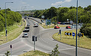
and runs through several roundabouts with local routes. Many of these roundabouts formerly experienced long queues, but since 2005, most have been signalised, resulting in reduced congestion. The junction with the M32 motorway still experiences long delays despite the introduction of traffic lights.
The road reappears 1.3 miles (2.1 km) along the A4 at Brislington
Brislington
Brislington is an area in the south east of the city of Bristol, England. It is on the edge of Bristol and from Bath. The Brislington Brook runs through the area in the woodlands of Nightingale Valley...
, where it follows a valley, crosses the A37
A37 road
The A37 is a major road in southern England. It runs north from the A35 at Dorchester in Dorset into Somerset through Yeovil and Shepton Mallet before terminating at the Three Lamps junction with the A4 in central Bristol...
, and reaches a large roundabout in Hengrove Park
Hengrove
Hengrove is a suburb and council ward of Bristol, England, situated between Whitchurch, Knowle and Bishopsworth, running along both dual carriageways, Wells Road and Airport Road . It consists mainly of working to middle class terrace houses. It contains an infant, primary and secondary school...
. West of this roundabout a strip of land has been left undeveloped, but at present the road instead turns north terminating at the A38 in Bedminster.
Future plans
There have been several proposals to extend the ring road from the junction with the A4 at Hicks Gate, Keynsham, along the southern edge of BristolBristol
Bristol is a city, unitary authority area and ceremonial county in South West England, with an estimated population of 433,100 for the unitary authority in 2009, and a surrounding Larger Urban Zone with an estimated 1,070,000 residents in 2007...
as far as the A370
A370 road
The A370 is a primary road in England running from Bristol to Weston-super-Mare and on to East Brent in Somerset. A more direct route from Bristol to East Brent is the A38.-Route:...
at Long Ashton
Long Ashton
Long Ashton is a village and civil parish in Somerset, England. It falls within the Unitary Authority of North Somerset, a few miles south west of the city of Bristol. The parish has a population of 4,981...
.
The 2005 Greater Bristol Strategic Transport Study, commissioned by the regional government office
South West England
South West England is one of the regions of England defined by the Government of the United Kingdom for statistical and other purposes. It is the largest such region in area, covering and comprising Bristol, Gloucestershire, Somerset, Dorset, Wiltshire, Devon, Cornwall and the Isles of Scilly. ...
, recommended construction of the new southern route to tackle congestion. The proposals follow the route set aside west from Hengrove Park roundabout to the A38 at Castle Farm (phase 1), and from there to the A370 near Long Ashton Park and Ride (phase 2). There are additional recommendations (phase 3) for a new Whitchurch bypass from Hengrove Park roundabout, along the base of Dundry Hill, around Stockwood and joining the existing A4174 at Hicks Gate roundabout on the A4. Phase one and two of the ring road are the only major road building schemes adopted by the Joint Local Transport Plan, which claimed they would reduce delays across the Greater Bristol area by 6%, and lead to a 9% increase in public transport use. Bristol City Council has endorsed all three phases, and was hoping to begin construction of the first two phases in 2010 and 2011, and the third phase some time after 2016. However, the plan has not been approved by the Department for Transport
Department for Transport
In the United Kingdom, the Department for Transport is the government department responsible for the English transport network and a limited number of transport matters in Scotland, Wales and Northern Ireland which are not devolved...
.