

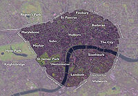
London Inner Ring Road
Encyclopedia
Road
A road is a thoroughfare, route, or way on land between two places, which typically has been paved or otherwise improved to allow travel by some conveyance, including a horse, cart, or motor vehicle. Roads consist of one, or sometimes two, roadways each with one or more lanes and also any...
s that encircle the centremost part of London
London
London is the capital city of :England and the :United Kingdom, the largest metropolitan area in the United Kingdom, and the largest urban zone in the European Union by most measures. Located on the River Thames, London has been a major settlement for two millennia, its history going back to its...
. The ring road previously formed the boundary of the London congestion charge
London congestion charge
The London congestion charge is a fee charged for some categories of motor vehicle to travel at certain times within the Congestion Charge Zone , a traffic area in London. The charge aims to reduce congestion, and raise investment funds for London's transport system...
zone before the western expansion.
Starting at the northernmost point and moving clockwise
Clockwise
Circular motion can occur in two possible directions. A clockwise motion is one that proceeds in the same direction as a clock's hands: from the top to the right, then down and then to the left, and back to the top...
, the road
Road
A road is a thoroughfare, route, or way on land between two places, which typically has been paved or otherwise improved to allow travel by some conveyance, including a horse, cart, or motor vehicle. Roads consist of one, or sometimes two, roadways each with one or more lanes and also any...
s defining the boundary are Pentonville Road, City Road
City Road
City Road or The City Road is a road that runs through inner north and central London. The northwestern extremity of the road is at the Angel, Islington where it forms a continuation of Pentonville Road. Pentonville Road itself is the modern name for London's first bypass, the New Road from...
, Old Street
Old Street
Old Street is a street in east London that runs west to east from Goswell Road in Clerkenwell, in the London Borough of Islington, to the crossroads where it intersects with Shoreditch High Street , Kingsland Road and Hackney Road in Shoreditch in the London Borough of Hackney.The nearest...
, Great Eastern Street
Shoreditch
Shoreditch is an area of London within the London Borough of Hackney in England. It is a built-up part of the inner city immediately to the north of the City of London, located east-northeast of Charing Cross.-Etymology:...
, Commercial Street
Commercial Street (London)
Commercial Street is a road in Tower Hamlets, east London that runs north to south from Shoreditch High Street to Whitechapel High Street through the East End district of Spitalfields...
, Mansell Street, Tower Bridge
Tower Bridge
Tower Bridge is a combined bascule and suspension bridge in London, England, over the River Thames. It is close to the Tower of London, from which it takes its name...
, Tower Bridge Road, New Kent Road
New Kent Road
New Kent Road is a road in the London Borough of Southwark. The road was created in 1751 when the Turnpike Trust upgraded a local footpath. This was done as part of the general road improvements associated with the creation of Westminster Bridge; in effect it was possible to travel from the West...
, the Elephant & Castle
Elephant and Castle
The Elephant and Castle is a major road intersection in south London, England, located in the London Borough of Southwark. It is also used as a name for the surrounding area....
, Kennington Lane, the roads that constitute the Vauxhall
Vauxhall
-Demography:Many Vauxhall residents live in social housing. There are several gentrified areas, and areas of terraced townhouses on streets such as Fentiman Road and Heyford Avenue have higher property values in the private market, however by far the most common type of housing stock within...
one-way system and Vauxhall Bridge
Vauxhall Bridge
Vauxhall Bridge is a Grade II* listed steel and granite deck arch bridge in central London. It crosses the River Thames in a south–east north–west direction between Vauxhall on the south bank and Pimlico on the north bank...
, Vauxhall Bridge Road, the roads that constitute the Victoria
Victoria, London
Victoria is a commercial and residential area of inner city London, lying wholly within the City of Westminster, and named after Queen Victoria....
one-way system, Grosvenor Place, Park Lane
Park Lane (road)
Park Lane is a major road in the City of Westminster, in Central London.-History:Originally a country lane running north-south along what is now the eastern boundary of Hyde Park, it became a fashionable residential address from the eighteenth century onwards, offering both views across Hyde Park...
, Edgware Road
Edgware Road (London)
Edgware Road is a major street which passes through the west of central London, England, starting at Marble Arch in the City of Westminster and working its way up to Edgware in the London Borough of Barnet. It is also the divider of several North London boroughs...
, Marylebone Road
Marylebone Road
Marylebone Road is an important thoroughfare in central London, within the City of Westminster. It runs east-west from the Euston Road at Regent's Park to the A40 Westway at Paddington...
and Euston Road
Euston Road
Euston Road is an important thoroughfare in central London, England, and forms part of the A501. It is part of the New Road from Paddington to Islington, and was opened as part of the New Road in 1756...
.
The route is described as the "Inner" Ring Road because there are two further sets of roads that have been described as London ring roads. The North
A406 road
The A406 or the North Circular Road is a road which crosses North London, UK, linking West and East London. It, together with the South Circular Road, forms a ring road through the inner part of Outer London...
and South Circular
A205 road
The A205 or South Circular Road is a direct route which crosses South London, UK, running from Woolwich in the east to the junction of the A406 , the M4 and the A4 at Gunnersbury in the west....
Roads together form the second ring road around London, averaging 10–15 mi (16.1–24.1 ) in diameter. The M25 motorway
M25 motorway
The M25 motorway, or London Orbital, is a orbital motorway that almost encircles Greater London, England, in the United Kingdom. The motorway was first mooted early in the 20th century. A few sections, based on the now abandoned London Ringways plan, were constructed in the early 1970s and it ...
is the outermost road encircling the metropolis, at an average diameter of 40 –.
History
Plans for an Inner Ring Road were put forward by Patrick AbercrombiePatrick Abercrombie
Sir Leslie Patrick Abercrombie ) was an English town planner. Educated at Uppingham School, Rutland; brother of Lascelles Abercrombie, poet and literary critic.-Career:...
in the 1940s, in the County of London Plan
County of London Plan
The County of London Plan was prepared for the London County Council in 1943. Its authors were John Henry Forshaw and Sir Leslie Patrick Abercrombie ....
.
Constituent Roads
- A100 (Tower Bridge Road, Tower Bridge Approach)
- A1202 (Commercial Street)
- A1210/A1211 (Mansell Street)
- A201 (New Kent Road)
- A202A202 roadThe A202 is a primary A road in London. It runs from New Cross Gate to London Victoria station. The section forming part of the London Inner Ring Road is known as Vauxhall Bridge Road.-Camberwell New Road:...
(Vauxhall Bridge Road) - A302 (Grosvenor Place, Lower Grosvenor Place, Bressenden Place)
- A3204 (Kennington Lane)
- A4202Park Lane (road)Park Lane is a major road in the City of Westminster, in Central London.-History:Originally a country lane running north-south along what is now the eastern boundary of Hyde Park, it became a fashionable residential address from the eighteenth century onwards, offering both views across Hyde Park...
(Park Lane) - A5 (southern section of the Edgware Road between Sussex Gardens and Marble ArchMarble ArchMarble Arch is a white Carrara marble monument that now stands on a large traffic island at the junction of Oxford Street, Park Lane, and Edgware Road, almost directly opposite Speakers' Corner in Hyde Park in London, England...
) - A501 (from Paddington stationPaddington stationPaddington railway station, also known as London Paddington, is a central London railway terminus and London Underground complex.The site is a historic one, having served as the London terminus of the Great Western Railway and its successors since 1838. Much of the current mainline station dates...
to MoorgateMoorgateMoorgate was a postern in the London Wall originally built by the Romans. It was turned into a gate in the 15th century. Though the gate was demolished in 1762, the name survives as a major street in the City of London...
via Kings CrossKings Cross, LondonKing's Cross is an area of London partly in the London Borough of Camden and partly in the London Borough of Islington. It is an inner-city district located 2.5 miles north of Charing Cross. The area formerly had a reputation for being a red light district and run-down. However, rapid regeneration...
, along City RoadCity RoadCity Road or The City Road is a road that runs through inner north and central London. The northwestern extremity of the road is at the Angel, Islington where it forms a continuation of Pentonville Road. Pentonville Road itself is the modern name for London's first bypass, the New Road from...
, Pentonville Road and Euston RoadEuston RoadEuston Road is an important thoroughfare in central London, England, and forms part of the A501. It is part of the New Road from Paddington to Islington, and was opened as part of the New Road in 1756...
). It formed part of the historical New Road.
Historical New Road
Construction on the New Road from Paddington to Islington began in 1756 to relieve congestion in the built-up area of London. At that time the districts of MaryleboneMarylebone
Marylebone is an affluent inner-city area of central London, located within the City of Westminster. It is sometimes written as St. Marylebone or Mary-le-bone....
, Fitzrovia
Fitzrovia
Fitzrovia is a neighbourhood in central London, near London's West End lying partly in the London Borough of Camden and partly in the City of Westminster ; and situated between Marylebone and Bloomsbury and north of Soho. It is characterised by its mixed-use of residential, business, retail,...
and Bloomsbury
Bloomsbury
-Places:* Bloomsbury is an area in central London.* Bloomsbury , related local government unit* Bloomsbury, New Jersey, New Jersey, USA* Bloomsbury , listed on the NRHP in Maryland...
were on the northern edge of the city, and only the southern parts of them had been built up. The New Road ran through the fields to the north of these three neighbourhoods.
The road is now one of the busiest main roads in the city. It runs from Edgware Road in the west to The Angel, Islington
The Angel, Islington
Angel is a district of London, England, and part of the London Borough of Islington. The area is identified in the London Plan as one of 35 major centres in Greater London.-History:...
, in the east. The western section between Edgware Road and Great Portland Street
Great Portland Street
Great Portland Street is a street in the West End of London. Linking Oxford Street with Albany Street and the busy A501 Marylebone Road and Euston Road, the road forms the boundary between Fitzrovia to the east and Marylebone to the west...
is known as Marylebone Road
Marylebone Road
Marylebone Road is an important thoroughfare in central London, within the City of Westminster. It runs east-west from the Euston Road at Regent's Park to the A40 Westway at Paddington...
; the central section between Great Portland Street and King's Cross is known as Euston Road
Euston Road
Euston Road is an important thoroughfare in central London, England, and forms part of the A501. It is part of the New Road from Paddington to Islington, and was opened as part of the New Road in 1756...
; and the eastern section from King's Cross to The Angel is called Pentonville Road.
City Road
City Road
City Road or The City Road is a road that runs through inner north and central London. The northwestern extremity of the road is at the Angel, Islington where it forms a continuation of Pentonville Road. Pentonville Road itself is the modern name for London's first bypass, the New Road from...
was constructed in 1761 to continue the route eastwards to the northern edge of the City of London
City of London
The City of London is a small area within Greater London, England. It is the historic core of London around which the modern conurbation grew and has held city status since time immemorial. The City’s boundaries have remained almost unchanged since the Middle Ages, and it is now only a tiny part of...
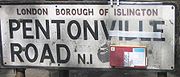
Pentonville Road
City Road
City Road or The City Road is a road that runs through inner north and central London. The northwestern extremity of the road is at the Angel, Islington where it forms a continuation of Pentonville Road. Pentonville Road itself is the modern name for London's first bypass, the New Road from...
.
By far the greater portion of the road is in the London Borough of Islington
London Borough of Islington
The London Borough of Islington is a London borough in Inner London. It was formed in 1965 by merging the former metropolitan boroughs of Islington and Finsbury. The borough contains two Westminster parliamentary constituencies, Islington North and Islington South & Finsbury...
but a small part near Kings Cross is in the London Borough of Camden
London Borough of Camden
In 1801, the civil parishes that form the modern borough were already developed and had a total population of 96,795. This continued to rise swiftly throughout the 19th century, as the district became built up; reaching 270,197 in the middle of the century...
, including an entrance to Kings Cross St Pancras tube station at the former Kings Cross Thameslink station. It acquired its present name in 1857.
There are several halls of residence located on Pentonville Road, these being Dinwiddy House (SOAS), Paul Robeson House and Nido Student Living.
This street is distinguished by the "set back" housing lines originally intended to provide an atmosphere of spaciousness along the thoroughfare. It is one of the locations on the London version of the Monopoly board game
Monopoly (game)
Marvin Gardens, the leading yellow property on the board shown, is actually a misspelling of the original location name, Marven Gardens. The misspelling was said to be introduced by Charles Todd and passed on when his home-made Monopoly board was copied by Charles Darrow and thence to Parker...
.
Mansell Street
Mansell Street is a short road, part of the A1210 route (though sometimes shown as being the A1211), which for most of its length marks the boundary between the City of LondonCity of London
The City of London is a small area within Greater London, England. It is the historic core of London around which the modern conurbation grew and has held city status since time immemorial. The City’s boundaries have remained almost unchanged since the Middle Ages, and it is now only a tiny part of...
and the London Borough of Tower Hamlets
London Borough of Tower Hamlets
The London Borough of Tower Hamlets is a London borough to the east of the City of London and north of the River Thames. It is in the eastern part of London and covers much of the traditional East End. It also includes much of the redeveloped Docklands region of London, including West India Docks...
, though the southernmost part is entirely in Tower Hamlets. It runs from Aldgate
Aldgate
Aldgate was the eastern most gateway through London Wall leading from the City of London to Whitechapel and the east end of London. Aldgate gives its name to a ward of the City...
southwards to the Tower of London
Tower of London
Her Majesty's Royal Palace and Fortress, more commonly known as the Tower of London, is a historic castle on the north bank of the River Thames in central London, England. It lies within the London Borough of Tower Hamlets, separated from the eastern edge of the City of London by the open space...
. The northern part, north of the junction with Goodmans Yard and Prescot Street, has one way northbound traffic, while the southern part has one way southbound traffic.
Mansell Street is also named in Google maps in Guernsey Channel Islands with 'upper' and 'lower' Mansell Street connecting lower Vauvert to 'Upper' Mill Street onto Back Street and Mansell Street has its original 'cobble' Blue Granite surface still in place as other attaching streets have part 'tarmac' covered 'cobbles'.
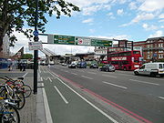
Tower Bridge Road

Road
A road is a thoroughfare, route, or way on land between two places, which typically has been paved or otherwise improved to allow travel by some conveyance, including a horse, cart, or motor vehicle. Roads consist of one, or sometimes two, roadways each with one or more lanes and also any...
in Bermondsey
Bermondsey
Bermondsey is an area in London on the south bank of the river Thames, and is part of the London Borough of Southwark. To the west lies Southwark, to the east Rotherhithe, and to the south, Walworth and Peckham.-Toponomy:...
in the London
London
London is the capital city of :England and the :United Kingdom, the largest metropolitan area in the United Kingdom, and the largest urban zone in the European Union by most measures. Located on the River Thames, London has been a major settlement for two millennia, its history going back to its...
Borough of Southwark
London Borough of Southwark
The London Borough of Southwark is a London borough in south east London, England. It is directly south of the River Thames and the City of London, and forms part of Inner London.-History:...
, UK
United Kingdom
The United Kingdom of Great Britain and Northern IrelandIn the United Kingdom and Dependencies, other languages have been officially recognised as legitimate autochthonous languages under the European Charter for Regional or Minority Languages...
, that runs north to south, and connects the Bricklayers' Arms
Bricklayers' Arms
Bricklayers' Arms is a busy road intersection between A2 and the London Inner Ring Road in south London, England. It is the junction of Tower Bridge Road, Old Kent Road, New Kent Road and Great Dover Street; Old Kent Road and New Kent Road east-bound are connected by a flyover.The area is named...
roundabout
Roundabout
A roundabout is the name for a road junction in which traffic moves in one direction around a central island. The word dates from the early 20th century. Roundabouts are common in many countries around the world...
and flyover at its southern end (New Kent Road
New Kent Road
New Kent Road is a road in the London Borough of Southwark. The road was created in 1751 when the Turnpike Trust upgraded a local footpath. This was done as part of the general road improvements associated with the creation of Westminster Bridge; in effect it was possible to travel from the West...
and Old Kent Road
Old Kent Road
The Old Kent Road is a road in South East London, England and forms part of Watling Street, the Roman road which ran from Dover to Holyhead. The street is famous as the equal cheapest property on the London Monopoly board and as the only one in South London....
) to Tower Bridge
Tower Bridge
Tower Bridge is a combined bascule and suspension bridge in London, England, over the River Thames. It is close to the Tower of London, from which it takes its name...
and across the River Thames
River Thames
The River Thames flows through southern England. It is the longest river entirely in England and the second longest in the United Kingdom. While it is best known because its lower reaches flow through central London, the river flows alongside several other towns and cities, including Oxford,...
at its northern end. It also links to Long Lane
Long Lane, Southwark
Long Lane is a major road in Southwark, south London, England.At the northwest end is a complicated junction with Borough High Street, Marshalsea Road, Tabard Street, and Great Dover Street. The historic St George the Martyr church, with Dickensian connections, is at this junction, now standing on...
.
The road has an abundance of antique (or junk) shops along part of its length. There is also Bermondsey Square which holds an 'antique' market every Friday morning, usually known as Bermondsey Market
Bermondsey Market
Officially called New Caledonian Market, Bermondsey Market is an antiques market located at Bermondsey Square on Tower Bridge Road in Bermondsey, part of the London Borough of Southwark, in South London, England...
, though officially as New Caledonian Market.
Towards its southern end are a collection of shops, pubs and takeaways.
Kennington Lane
Kennington Lane is an A-roadGreat Britain road numbering scheme
The Great Britain road numbering scheme is a numbering scheme used to classify and identify all roads in Great Britain. Each road is given a single letter, which represents the road's category, and a subsequent number, with a length of between 1 and 4 digits. Originally introduced to arrange...
(classified A3204) running between the Elephant & Castle to the east and Vauxhall
Vauxhall
-Demography:Many Vauxhall residents live in social housing. There are several gentrified areas, and areas of terraced townhouses on streets such as Fentiman Road and Heyford Avenue have higher property values in the private market, however by far the most common type of housing stock within...
to the west.
Starting at the Elephant, Kennington Lane splits off from the A3 by means of a Y-junction
3-way junction
A 3-way junction is a type of road junction with three arms. A Y junction generally has 3 arms of equal size...
, where Newington Butts
Newington Butts
Newington Butts is a former village, now an area of the London Borough of Southwark, that gives its name to a segment of the A3 road running south-west from the Elephant and Castle junction...
becomes Kennington Park Road
Kennington Park Road
Kennington Park Road is a main road in south-east London, England, and is part of the A3 trunk road. It runs from Newington Butts at its Y-junction with Kennington Lane, south-west to the Oval, where the A3 continues as Clapham Road, towards Stockwell...
. Heading in a southwesterly direction, the road then crosses the A23
A23 road
The A23 road is a major road in the United Kingdom between London and Brighton, East Sussex. It became an arterial route following the construction of Westminster Bridge in 1750 and the consequent improvement of roads leading to the bridge south of the river by the Turnpike Trusts...
Kennington Road
Kennington Road
Kennington Road is a long straight road, approximately a mile in length, in the London Borough of Lambeth in London, England, running south from Westminster Bridge Road to Kennington Park Road....
, before reaching the Vauxhall one-way system, where the A3036 Albert Embankment
Albert Embankment
The Albert Embankment is a stretch of the river bank on the south side of the River Thames in Central London. It stretches approximately one mile northward from Vauxhall Bridge to Westminster Bridge, and is located in the London Borough of Lambeth.Albert Embankment is also the name given to the...
and Wandsworth Road
Wandsworth Road
Wandsworth Road could refer to either:*Part of the A3036 road.*Wandsworth Road railway station....
, A202
A202 road
The A202 is a primary A road in London. It runs from New Cross Gate to London Victoria station. The section forming part of the London Inner Ring Road is known as Vauxhall Bridge Road.-Camberwell New Road:...
Vauxhall Bridge
Vauxhall Bridge
Vauxhall Bridge is a Grade II* listed steel and granite deck arch bridge in central London. It crosses the River Thames in a south–east north–west direction between Vauxhall on the south bank and Pimlico on the north bank...
, Durham Street and Harleyford Road, A203
A203 road
The A203 is a primary A road in South London. It runs from Brixton to Vauxhall connecting the A23 and A3 with Vauxhall Bridge, the Albert Embankment as well as the London Inner Ring Road for travel across the River Thames. Between Brixton and Stockwell tube station it is known as Stockwell Road...
South Lambeth Road, and A3205 Nine Elms Lane all converge.
Vauxhall Bridge Road
River Thames
The River Thames flows through southern England. It is the longest river entirely in England and the second longest in the United Kingdom. While it is best known because its lower reaches flow through central London, the river flows alongside several other towns and cities, including Oxford,...
to Victoria station
Victoria station (London)
Victoria station, also known as London Victoria, is a central London railway terminus and London Underground complex. It is named after nearby Victoria Street and not Queen Victoria. It is the second busiest railway terminus in London after Waterloo, and includes an air terminal for passengers...
. At the southernmost point the road runs past the headquarters of MI6.