Trehafod
Encyclopedia
Trehafod is a village
in the Rhondda
Valley between Porth
and Pontypridd
in the county borough
of Rhondda Cynon Taf, Wales
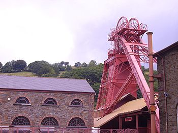
, although in administrative terms is split between the electoral division of Cymmer (Rhondda) to the West and Rhondda (Pontypridd) to the East. A former coal mining area, the village is now best known as the site of the Rhondda Heritage Park
, a tourist attraction reflecting industrial life of coal mining Rhondda.
 The 1847 tithe map
of the area shows a number of farms on the area that was to become Trehafod, these were named, Hafod Uchaf, Hafod Ganol and Hafod Fawr. It was from these farms that Trehafod was to take its name. Hafod is a Welsh
word that can mean "summer dwelling" or "upland farm".
Trehafod railway station
lies on the Rhondda Line
which follows the River Rhondda
; the railway line and river border the village on either side.
Trehafod is now most famous for the Rhondda Heritage Park which was once the Lewis Merthyr colliery, at the peak time for coal mining
production, one of the most productive collieries in the South Wales Coalfield
.
Due to the river flowing very close to a lot of houses within the village there have been a number of floodings. The biggest floods were in 1960, which claimed the life of one man who lived in Afon street. Afon is a Welsh
word that means river. In most streets, the whole lower level of buildings was submerged by water. Other years that floodings have occurred were 1921, 1929, 1979 and most recently in the mid 1990s. In the late 1990s the Trehafod stretch of the Rhondda river bank was reinforced, in an effort to prevent future floodings.
The village was visited by Queen Elizabeth II
on 13 June 2002 during her Jubilee tour of the UK. Other royal guests who have visited in the past include King George V
and Queen Mary
in 1912.
Village
A village is a clustered human settlement or community, larger than a hamlet with the population ranging from a few hundred to a few thousand , Though often located in rural areas, the term urban village is also applied to certain urban neighbourhoods, such as the West Village in Manhattan, New...
in the Rhondda
Rhondda
Rhondda , or the Rhondda Valley , is a former coal mining valley in Wales, formerly a local government district, consisting of 16 communities built around the River Rhondda. The valley is made up of two valleys, the larger Rhondda Fawr valley and the smaller Rhondda Fach valley...
Valley between Porth
Porth
Porth is a town and a community in the county borough of Rhondda Cynon Taf, within the historic county boundaries of Glamorgan, Wales, lying in the Rhondda Valley and is regarded as the gateway to the Rhondda Fawr and Rhondda Fach valleys because both valleys meet at Porth...
and Pontypridd
Pontypridd
Pontypridd is both a community and a principal town of Rhondda Cynon Taf, Wales and is situated 12 miles/19 km north of the Welsh capital city of Cardiff...
in the county borough
County borough
County borough is a term introduced in 1889 in the United Kingdom of Great Britain and Ireland , to refer to a borough or a city independent of county council control. They were abolished by the Local Government Act 1972 in England and Wales, but continue in use for lieutenancy and shrievalty in...
of Rhondda Cynon Taf, Wales
Wales
Wales is a country that is part of the United Kingdom and the island of Great Britain, bordered by England to its east and the Atlantic Ocean and Irish Sea to its west. It has a population of three million, and a total area of 20,779 km²...
, although in administrative terms is split between the electoral division of Cymmer (Rhondda) to the West and Rhondda (Pontypridd) to the East. A former coal mining area, the village is now best known as the site of the Rhondda Heritage Park
Rhondda Heritage Park
Rhondda Heritage Park, Trehafod, Rhondda, South Wales is a tourist attraction which offers an insight into the life of the coal mining community that existed in the area until the 1980s....
, a tourist attraction reflecting industrial life of coal mining Rhondda.
History

Tithe maps
The term Tithe map is usually applied to a map of an English or Welsh parish or township, prepared following the Tithe Commutation Act 1836. This act allowed tithes to be paid in cash rather than goods. The map and its accompanying schedule gave the names of all owners and occupiers of land in the...
of the area shows a number of farms on the area that was to become Trehafod, these were named, Hafod Uchaf, Hafod Ganol and Hafod Fawr. It was from these farms that Trehafod was to take its name. Hafod is a Welsh
Welsh language
Welsh is a member of the Brythonic branch of the Celtic languages spoken natively in Wales, by some along the Welsh border in England, and in Y Wladfa...
word that can mean "summer dwelling" or "upland farm".
Trehafod railway station
Trehafod railway station
Trehafod railway station is a railway station serving the township of Trehafod in Rhondda Cynon Taf, Wales. It is located on the Rhondda Line.It was first opened on this site by the Taff Vale Railway in 1893.-History:...
lies on the Rhondda Line
Rhondda Line
The Rhondda Line is a commuter railway line in South Wales from Cardiff to Treherbert. The line follows the Merthyr Line as far as Pontypridd, where it then diverges to continue along the Rhondda Valley.The places served by the line are listed below:...
which follows the River Rhondda
River Rhondda
The River Rhondda is a river in the Rhondda Valley, South Wales which has two major tributaries; the Rhondda Fawr and the Rhondda Fach .- Description :...
; the railway line and river border the village on either side.
Trehafod is now most famous for the Rhondda Heritage Park which was once the Lewis Merthyr colliery, at the peak time for coal mining
Coal mining
The goal of coal mining is to obtain coal from the ground. Coal is valued for its energy content, and since the 1880s has been widely used to generate electricity. Steel and cement industries use coal as a fuel for extraction of iron from iron ore and for cement production. In the United States,...
production, one of the most productive collieries in the South Wales Coalfield
South Wales Coalfield
The South Wales Coalfield is a large region of south Wales that is rich with coal deposits, especially the South Wales Valleys.-The coalfield area:...
.
Due to the river flowing very close to a lot of houses within the village there have been a number of floodings. The biggest floods were in 1960, which claimed the life of one man who lived in Afon street. Afon is a Welsh
Welsh language
Welsh is a member of the Brythonic branch of the Celtic languages spoken natively in Wales, by some along the Welsh border in England, and in Y Wladfa...
word that means river. In most streets, the whole lower level of buildings was submerged by water. Other years that floodings have occurred were 1921, 1929, 1979 and most recently in the mid 1990s. In the late 1990s the Trehafod stretch of the Rhondda river bank was reinforced, in an effort to prevent future floodings.
The village was visited by Queen Elizabeth II
Elizabeth II of the United Kingdom
Elizabeth II is the constitutional monarch of 16 sovereign states known as the Commonwealth realms: the United Kingdom, Canada, Australia, New Zealand, Jamaica, Barbados, the Bahamas, Grenada, Papua New Guinea, the Solomon Islands, Tuvalu, Saint Lucia, Saint Vincent and the Grenadines, Belize,...
on 13 June 2002 during her Jubilee tour of the UK. Other royal guests who have visited in the past include King George V
George V of the United Kingdom
George V was King of the United Kingdom and the British Dominions, and Emperor of India, from 6 May 1910 through the First World War until his death in 1936....
and Queen Mary
Mary of Teck
Mary of Teck was the queen consort of the United Kingdom and the British Dominions, and Empress of India, as the wife of King-Emperor George V....
in 1912.

