
A38 road
Encyclopedia
The A38, part of which is also known as the Devon Expressway, is a major A-class trunk road
in England.
The road runs from Bodmin
in Cornwall
to Mansfield
in Nottinghamshire
. It is 292 miles (469.9 km) long, making it one of the longest A-roads in England. It was formerly known as the Leeds — Exeter Trunk Road, when this description also included the A61. Prior to the opening of the M5 motorway
in the 1960s and 1970s, the A38 formed the main "holiday route" from the Midlands to Somerset
, Devon
and Cornwall.
Considerable lengths of the road in the West Midlands
closely follow Roman roads, including part of Icknield Street
. Between Worcester
and Birmingham
the current A38 follows the line of a Saxon salt road
;
at a junction with the A30
before traversing the edge of the town to meet the A30 again. It travels through the picturesque Glynn Valley to Dobwalls
and Liskeard
, which are bypassed by a dual carriageway
. The Dobwalls section contains the most sophisticated bat bridge
yet constructed in the UK. The A38 continues through the Cornish countryside, bypassing the centre of Saltash
and continuing through the Saltash Tunnel
. Immediately after the tunnel the River Tamar
is crossed using the Tamar Bridge
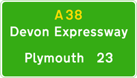
where the route resumes dual carriageway status. The section from Plymouth to Exeter is called the 'Devon Expressway', it forms the southern border of Dartmoor National Park
, and serves as a southward extension of the M5 motorway
opening in 1977.. It is 42 miles (67.6 km) long and was completed in the early 1970s. There are several grade separated junctions
along its length mainly for local traffic; including a three-level stacked roundabout
for the A386, which heads out towards Dartmoor
National Park. The route was reserved for the Parkway as early as 1943, when it was included in the Plan for Plymouth. In the early 1990s, the Marsh Mills junction was significantly remodelled, reducing the size of the roundabout and building a flyover over the top of it, allowing free flowing access from the Plympton bypass onto the Parkway. The viaducts carrying the A38 over the River Plym
, which after the construction of the Marsh Mills flyover became the Exeter bound sliproads, were built in 1969-1970 as part of the Plympton bypass. They were replaced in the 1990s due to suffering from Alkali Silica Reaction
, and the project, completed in February 1996 at a cost of £12.25million, involved the world's largest sideways bridge slide at the time for the 410 metres (1,345.1 ft), 5,500 tonne bridge. This required the road to be closed for only 48 hours, which won it an AA
National Motoring Award in 1996 for innovation and minimisation of traffic congestion.
The South Brent
bypass opened in 1974 and the Ivybridge
bypass in 1973, both on new alignments. The A38 passes Endsleigh Garden Centre, which used to have direct access from the dual carriageway, although since the early 2000s this has been closed and the garden centre is accessed from the Westover junction for Ivybridge. After Ivybridge, the route roughly parallels the original route, bypassing the village of Lee Mill which is now home to a large trading estate. The road widens to a three-lane dual carriageway for the Plympton
bypass. This opened in 1971 and was the first section of the Devon Expressway to built on a new alignment, as well as being the first sizeable dual carriageway section of the route. The route originally ended at the Marsh Mills roundabout, which when opened was the largest in Europe.
The section of the A38 between the A382 junction and Ashburton
was built on a new alignment parallel to the old road, and was opened in 1974. Trago Mills
, a locally well known furniture store and leisure centre, is passed by the road. The Ashburton bypass, much like the Kennford bypass, uses the alignment of a much older 1930s single carriageway bypass, which was subsequently upgraded to dual carriageway by 1974. At the village of Buckfastleigh
, the route once again bypasses on a new alignment, although due to the challenging topography of the area, the road crosses part of the village on a viaduct. From Buckfastleigh to the A385 junction, the current road follows the route of original single carriageway, with the majority of this section being upgraded between 1973 and 1974, although a small section at Dean Prior was upgraded between 1966 and 1967. This section is of a poor quality when compared to the majority of the route between Exeter and Plymouth, containing several side turnings with short exit/entry slips, and properties which back onto the road.
 The town of Chudleigh
and the village of Chudleigh Knighton
are bypassed on a new alignment, which opened in 1973, and the following section at Heathfield up to the A382 junction was upgraded from the original route between 1966 and 1968. Some of this section follows part of the old Teign Valley Line
railway.
Before Kennford, the route splits, with the A38 heading for Plymouth and the A380
heading towards Torbay
. At this point, the road becomes a dual two-lane road although a third-lane emerges immediately for uphill traffic as the route climbs Haldon Hill
, which has an average gradient of 1 in 20 over a 4 km distance, and a maximum gradient of around 1 in 10 (the adjacent A380 Telegraph Hill has about the same maximum gradient). The third lane is lost at the top of the hill, and the next section, the Harcombe bends is an original dual carriageway section, older than the rest of the route and this is evident with its sharp bends.
The Devon Expressway ends near the village of Kennford
, south of Exeter, at the terminus of the M5. This initial section was opened in 1977, along with the remaining section of the M5, and is a three-lane dual carriageway. The village of Kennford is bypassed, on an alignment of a 1930s bypass, which was upgraded to dual carriageway in the 1960s and then widened to a dual three-lane road in 1975.
A junction to the south of Exeter
represents a third meeting point of the A38 with the A30, from which point the A38 multiplexes
with the M5 before re-emerging from junction 27 near Waterloo Cross, 21 miles (33.8 km) north of Exeter. From junction 27 the A38 heads north via Wellington
, Taunton
, Bridgwater
, Highbridge
and Bristol
. From Waterloo Cross to Birmingham, the road is paralleled by the M5, where the A38 has reverted to taking local traffic only.
From Bristol, it continues north via Gloucester
, Tewkesbury
, Worcester
and Bromsgrove
to Birmingham
. Between Worcester and Birmingham the A38 followed the line of an identified Saxon Salt road
, one of six leading out of Droitwich. At Bromsgrove, it meets the M42
and the B4096 at junction 1 at Lickey End
.
 It passes through Upper Catshill
and meets the M5
at junction 4 near Lydiate Ash
. From here to Edgbaston
, the road is mostly dual carriageway, single-lane sections having been replaced in the first decade of the 21st century (see history section, below).
In the centre of Birmingham, a section of the road becomes the Aston Expressway A38(M) motorway
, running from the north-eastern side of the Inner Ring Road
through Aston
to the junction with the M6 motorway
at Gravelly Hill Interchange
, better known as Spaghetti Junction.
The West Midlands section of the A38 is one of the areas chosen by the Highways Agency
to monitor the effectiveness of driver location signs
in assisting motorists to communicate their location to the emergency services.
and Lichfield
, before taking up the route of the Roman road, Ryknild Street
, (also spelt Icknield or Rykneld), as far as Derby
. At Wychnor
, the road crosses the River Trent
and enters the district of East Staffordshire
. At Barton Turn, near the B5016 junction, the road runs right alongside the Cross Country Route for around 1 miles (1.6 km). This railway line follows the line of the A38 from Derby to Plymouth. From Alrewas to Burton, the path called The Way for the Millennium follows the northbound carriageway.
From Clay Mills, the road passes through the district of South Derbyshire
, passing the grade separated junction with the A5132 for Willington
. There is the Derby with Burton services at the Burnaston
A50
interchange. The road enters the City of Derby borough 0.5 mile (0.80467 km) north of the Littleover
interchange. For nearly 4 miles (6.4 km), the A38 forms part of Derby's outer ring road, including three roundabouts: Kingsway (or Grand Canyon) for the A5111; Markeaton
for the A52
; and Little Eaton
(or Abbey Hill) for the A61 and B6179. The section of road between Kingsway roundabout to just north of Markeaton is urban in nature and thus subject to a 40 mi/h speed limit.
Originally terminating in Derby at the junction of Babington Lane with St Peter's Street (formerly the A6), The road enters the district of Amber Valley where it passes Drum Hill just north of Little Eaton and is crossed at this point by the Midshires Way
and Centenary Way. There is a junction for the B6179 to Ripley and Belper
. At Alfreton, there is a grade separated junction with the A61, A615 and B6179. The section from Alfreton to the M1, the Alfreton-South Normanton
Bypass, opened as the A615 in the late 1960s. This section has a grade separated junction with the B600 for Somercotes
and the Cotes Park industrial estate, and where it crosses the Nottingham spur of the Midland Main Line
it enters the district of Bolsover
.
As a 1970s upgrade to the route of the A61 north of Derby (which became the B6179), the A38 bypasses Ripley
passing through former opencast mining land, before joining end-on with the former A615 Alfreton bypass at Watchorn Intersection. The road crosses the M1
at junction 28. Into Nottinghamshire
, the road bypasses Sutton-in-Ashfield
, dropping to a single carriageway configuration of 1980s construction, including multiple traffic light controlled junctions – such as the Mansfield, Ashfield Regeneration Route ("MARR"). The final section of the A38 from Sutton, past King's Mill Hospital
into Mansfield
, is purely urban in nature and is single carriageway, joining the A6009 in Mansfield Town Centre at the end of the route from Cornwall to the North Midlands.
to a junction with the A30 at Bodmin. When the Tamar Bridge was opened in 1961, the A38 was rerouted on the former line of the A374
, through Tideford, over the new bridge and through Crownhill
, joining the old route at Plympton. The old route of the A38, via Torpoint and the centre of Plymouth, was redesignated the A374.
The A38 was extended north from Derby to the M1 motorway and Mansfield in 1977, partly on the former line of the A615.
bypass, stretching for 6 miles (10 km) from the west of Liskeard to Trerulefoot
, opened in June 1976.
A public inquiry was held for the Dobwalls
bypass in February 2005, which was expected to cost £32 million. The bottleneck was removed when the bypass, linking the existing Liskeard bypass to the current single carriageway section through the Glynn Valley opened in the Winter of 2008. A campaign to open this road was started by villagers in Dobwalls in 1930, but planning for building the road was not granted until 2006, the work starting on 15 November that year.
In a separate improvement within the Glynn Valley, the Highways Agency
stabilised a 840 metre (0.521953098785838 mi) section of the road near Bodmin Parkway railway station
. The work, which commenced in October 2007, was carried out to shore-up the verge which had been built on an embankment
supported by dry stone walling and the root systems of large trees. It was completed in May 2008 seeing the installation of kerbing, road drainage gulleys, safety barriers as well as increasing the verge width to allow for a new surface water drainage system.
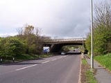
outside Plymouth and junction 31 of the M5, where the motorway ends; this section is known as the Devon Expressway. It is mainly a two-lane dual carriageway which runs between Exeter
and Plymouth
serving as a continuation of the M5 motorway. It is a common route for tourists travelling to Cornwall
, though those wanting to use a continuous dual carriageway route to Cornwall can use the A30
rather than the Devon Expressway. It then runs concurrently with the M5 until junction 27, where it splits and enters Somerset independent but parallel to the M5.
During the mid 1960s, small sections of the route between Plymouth and Exeter were upgraded to dual carriageway, such as those at Dean Prior and Heathfield. This was followed by the construction of Plympton bypass in 1970-71, with the majority of realignment, such as the Ivybridge and Buckfastleigh bypasses, being completed during 1973-74. The route, now known as the Devon Expressway, was largely complete by 1975, with the final section between Kennford and the M5 opening in 1977, coinciding with the completion of the M5 during the same year. Whilst many of the sections were newly constructed realignments, some sections such as the Ashburton and Kennford bypasses were upgraded from the original 1930s single carriageway bypasses. The Parkway, the section of dual carriageway through the suburbs of Plymouth between the Tamar Bridge and Marsh Mills, was constructed in 1983-84, along a route which had been reserved for this road since 1943. This was followed by the construction of a flyover over Marsh Mills roundabout in 1992, providing a non stop route between the Plympton bypass and the Parkway.
The Plympton bypass was used for a stage in the 1974 Tour de France
, the first time the race
had ever come to the United Kingdom. Popular belief is held that the Plympton bypass was newly completed, but had not yet opened. In fact, the Plympton bypass had been open some three years earlier.
The viaducts carrying the A38 over the River Plym
, which after the construction of the Marsh Mills flyover became the Exeter bound sliproads, were built in 1969-1970 as part of the Plympton bypass. They were replaced in the 1990s due to suffering from Alkali Silica Reaction
, and the project, completed in February 1996 at a cost of £12.25million, involved the world's largest sideways bridge slide at the time for the 410 metres (1,345.1 ft), 5,500 tonne bridge. This required the road to be closed for only 48 hours, winning it an AA
National Motoring Award in 1996 for innovation and minimisation of traffic congestion.
As with any major road, accidents are likely to occur; however due to the substandard design of some sections of the route between Exeter and Plymouth, the accident rate has been identified as being above the national average for the type of road. A spate of accidents in April 2009 heightened local awareness of the issue, with local MP Gary Streeter
calling for a review of the road. A number of improvements have been made along the route in recent years, mainly being the replacement of worn-out road surfaces, such as those at Buckfastleigh and Ivybridge. These projects have also included the replacement of signage, and the reconstruction of exit/entry slips for side turnings, in a bid to make the road safer.
Presently, the route between Plymouth and the end of M5 is all dual carriageway, and branded the Devon Expressway, being the primary route that links Plymouth to the rest of the country.
Beyond the end of M5, the road runs concurrently with and as the M5 until junction 27. The original route between Exeter and junction 27 of the M5 (Waterloo Cross) was downgraded to become the B3181 when the M5 was opened in 1977
, the A38 runs broadly parallel to the motorway: junctions 22 to 27 are mostly spurs connecting to the road and all no further than 1.5 miles (2.4 km) from it. The A38 runs around Wellington
, through the county seat of Taunton
, North Petherton
and Highbridge
. Beyond Highbridge and junction 22, the road departs the motorway and resumes primary status, going through Winscombe
and Lower Langford
. This route is the suggested route for accessing the south of Bristol and Bristol Airport
from the South West.
The centre of Bridgwater
was a notorious bottle neck on the "holiday route" as traffic from both the A38 and the A39
had to negotiate through the town centre in order to cross the River Parrett
. The construction of a new reinforced concrete road bridge, the Blake Bridge, which opened in March 1958 as part of a southern bypass took much of the traffic away from the centre of Bridgwater. The opening of the M5 in 1974 further reduced the traffic pressure. This is complemented by a link road (Western Way) linking the A38 and the A39 north and west of the town respectively.
Much of the A38 through Somerset was built as single carriageway, with some three-lane passing points. However, the construction of the M5 through Somerset, in the early 1970s, led to the building of links between the A38 and the M5 in the form of new roundabouts on the A38 linking into adjacent junctions on the M5.
to the south west of the city, and enters the city itself at Highridge, along Bedminster Down
and into Bedminster. It runs through central Bristol
before leaving northwards through Stokes Croft
and along Gloucester Road
. It runs past Bristol Filton Airport to meet the M5 again at junction 15. Thereafter it runs through Almondsbury
and by-passes Thornbury
to enter Gloucestershire.
South of Bristol, the road was diverted in 2001 to cater for an extension of the runway and installation of a Category 3 landing system
at Bristol Airport. The route south of the city, despite serving the airport, is single carriageway and suffers from heavy volume of traffic at peak times, and congestion along Bedminster Down. Drivers from the south are advised by road signs not to follow the A38 into the city, but to use the A3029 Winterstoke road to enter from the west, as this route has a greater capacity. As part of the "Greater Bristol Strategic Transport Study", a link road is under consideration to the south of Bristol. This is in part due to the congestion at Winterstoke Road and Barrow Gurney, both of which are very busy, especially the latter where the road can only accommodate travelling at one direction at a given time; and the incomplete Bristol Ring Road (A4174).
The route to the north of the city is also very busy: it runs as a single carriageway up to the junction with the A4174 ring road
at Filton
, and where it runs as Gloucester Road is a busy shopping parade. Beyond the ring road, it runs as a dual carriageway past Bristol Filton Airport, which contains bases for Royal Mail, Airbus, Rolls Royce and others. Beyond the junction with M5 it runs as a broad single carriageway, again parallel to the M5 in route towards Gloucester.
The present road from Bristol through Horfield
was one of the additional roads added to the Bristol turnpike roads in 1749. This passed through Thornbury to Stone
, just beyond the boundary of South Gloucestershire
, where it met one of the Gloucester turnpike roads. From Almondsbury, the road approximately follows the line of the Roman road from Sea Mills
to Gloucester. The previous main route out of Bristol (one of twelve roads from the city, turnpiked in 1727 was Stapleton
and Hambrook
to the upper end of Tytherington
and thence to Stone. This seems to be parts of B4058
, B4424, and then unclassified roads. However, Ogilvy's Britannia shows a route following the B4058 as far as Cromhall
, then through Stinchcombe Bottom, Dursley
, and Cam
before joining the present road.
being the great road from the north to west of this kingdom". Much of the road, follows a Roman road, but deviates from it between Buckover and Whitfield
.
The A38 was rerouted along the Gloucester Bypass when it was built, and the old route through the city became the A430. In 2007 the Gloucester South Western Bypass opened to traffic, costing £43 million. Though it is numbered A430 and not technically part of the A38, traffic wishing to continue on the A38 on the other side of the city is signed to use the bypass, rather than the existing A38.
Beyond Gloucester, the A38 was probably only improved in 1756 under an Act dealing with roads from that city towards Cheltenham
and Tewkesbury
. The next section (from Coombe Hill
) was improved as one of the Tewkesbury roads, again from 1727. The Act refers to this as the Upper Way to Gloucester in contrast to the Lower Way, which went via Wainsload Bridge. When this Act was renewed in 1756, the road from Tewkesbury to the a farm house called the Old Blue Ball (now Bluebell Farm) was also included. This was in Earls Croome
, Worcestershire, and was where one of the Worcester
turnpikes ended. Much of this stretch of the road originated as a Roman road, but the later road left the Roman line near Naunton in Ripple
. The name Stratford Bridge on the county boundary confirms its Roman origin there.
turnpike trust's roads which was originally (in 1726) at Severn Stoke
, but an Act of 1737 extended it to Upton Bridge (taking it past Bluebell Farm).
North of the city, the road was a particularly important one as it connected the salt
making centre of Droitwich
with the river Severn. In 1706, this was described as heavily used for the 'carriage of salt, iron, coals and other wares'. The first Turnpike Act for this road was an extremely early one, being passed in 1713 and recites:
When it was renewed in 1725, it was extended from the Tything of Whistons to the Lower Slip of the Quay of Worcester; from Droitwich to Dyers Bridge near Bromsgrove
; and through the town of Droitwich frim "Netherwith" [Netherwich] Bridge to a place called "Chapel on the Bridge". In 1749, this was again extended through the town of Bromsgrove to Spadebourne Bridge, immediately north of the town. Where the road leaves Worcester, it again does not follow the line of the Roman road in the same direction until it picks up the Roman line, just south of Martin Hussingtree
. The Roman road took a more direct line over Rainbow Hill and through Blackpole, now B4550. From Martin Hussingtree, the A38 closely follows the Roman line to beyond Bromsgrove. The present road deviates from its line when it was originally classified at Droitwich where the main road is a bypass, the old road now mostly being B4090. This happens again at Bromsgrove, where A38 is again a bypass, the old line mostly now being B4091 and Bromsgrove High Street (now partly pedestrianised, then through the town centre.
A short distance north of where the old A38 (now declassified) joins the Bromsgrove bypass, is Lickey End
, where an old highway intersection has been replaced by Junction 1 of M42 motorway
. Here, the road is joined from the southeast by the B4096, Alcester Road, which was from 1754 one of the roads of the Alcester
turnpike trust. The continuation northwards of B4096 is called Old Birmingham Road, because it was the original route of the turnpike to Birmingham
, climbing to a pass in the Lickey Hills
. The Roman road also went through the same pass, but its route from to the pass was probably rather straighter. Beyond the motorway junction, the A38 was turnpiked, not as the turnpike to Birmingham, but to Halesowen
and Dudley
, by the 1726 Act that also turnpiked Old Birmingham Road. The next Acts appointed separate trustees for the Dudley Road in 1742 and for the Birmingham Road in 1748. The road from Lydiate Ash
to Longbridge
was laid out as a new road in the early 1830s. The road passed through the centre of Rubery until the £770,000 (£ as of ), Rubery
Bypass opened in December 1965.
Lydiate Ash was the northern end of the M5 for many years in the 1960s, with traffic transferring onto the A38, which was diverted at this point to link with the M5.
 At Longbridge, new turpike joined the Roman road and the original turnpike, and runs straight towards the city centre. Hutton, the Birmingham historian described the road:
, the road is likely to have been in use in the medieval period as the road approximately follows the boundary of the former Weoley Park, the great park belonging to Weoley Castle
. A 2.4 kilometres (1.5 mi) dual carriageway bypass (52.44696°N 1.93923°W) of the narrow section from Selly Oak to Bournbrook
opened in August 2011. This required new bridges to carry the Birmingham and Worcester Canal and the Cross-City railway line over the road. The destination of the Roman road was clearly Metchley Fort
, but A38 turns away towards the city centre.
North of the city centre, the A38 used to pass through Sutton Coldfield
town centre before a bypass was built. The old route between Erdington and Lichfield is now the A5127. It is not clear what turnpike trust was responsible for this road or even whether it was a turnpike.
) from the county boundary at Shenstone Woodend, through Shenstone
to Lichfield
was one of the roads of the Lichfield Turnpike Trust, established in 1729. However, this section of the old A38 has been replaced by new dual carriageways.
Beyond Lichfield, the old A38 (now A5127) joins the Roman Ryknild Street at Streethay
and immediately after that A5127 joins the present A38. Ryknild Street had to that point run roughly parallel to A38, but following a different line from Metchley through Wall
, its line sometimes being used by modern roads (including B4138).
The section from Lichfield to Alrewas
was dualled in 1958. The £500,000 (£ as of ), section from Alrewas to Wychnor Farm near Wychnor Hall
, and the £150,000 (£ as of ),section from Wychnor Farm to Barton Turn both opened in 1962. The further section of the route was improved to dual carriageway standard, including the £350,000 2.5 miles (4 km) section from Barton Turn
(near Barton-under-Needwood
) to Branston
in February 1964, bypassing Burton upon Trent
in June 1967 (costing £2.6M (£ as of ),), which stretched from Branston to Clay Mills and actually shortened the route – now the A5121 - by 1 miles (1.6 km)), and in recent years many of the at-grade junctions
have been upgraded or stopped-up.
This long stretch of road closely follows Ryknild Street (whose destination was the Roman fort at Little Chester
) until just short of Branston where A38 swings west, perhaps to avoid low ground. The Roman road is used by minor roads through the suburbs of Burton upon Trent and then A5121 to rejoin the present A38 beyond the river Dove near Clay Mills. The road from Lichfield to Burton upon Trent was another of the roads maintained by the Lichfield Turnpike Trust from 1729. This diverged from the present line at Branston, taking the road through the town centre, and is now classified as A5121. The road from Burton to Derby
was turpiked in 1753. Beyond the start of the Derby bypass, the old A38 has been reclassified as A5250. This follows Ryknild Street as far as Littleover
.
to the former A61 was opened, crossing the River Derwent
and Midland Main Line
.
Further improvements in the late 1960s and 1970s saw construction of the £5.2 million (£ as of ) Mickleover
bypass to the south-west of Derby opened on 19 February 1975. Although the government had approved the section through Allestree as early as 1974, before the Mickleover bypass had been completed, this section had a lot of objections from nearby residents, delaying its construction (from the A52
to the A6). It was opposed directly by Derby Borough Council and the former Derby Higher Education College
. The £17 million (£ as of ) road was eventually opened on 7 September 1983, known as Queensway. An extension of the A38 northwards, crossing the M1
at Junction 28, and ending in Mansfield
was built. The £3 million (£ as of ) Little Eaton
-Holbrook
Improvement opened on 3 October 1977.
The £12 million (£ as of ) 10 miles (16.1 km) Ripley
-Swanwick
Bypass was opened by Eric Varley
(MP for Chesterfield) on 21 October 1977, although the section from Alfreton to the Hartshay Hill roundabout with the A610
had been open to traffic since 5 September 1977.
Trunk road
A trunk road, trunk highway, or strategic road is a major road—usually connecting two or more cities, ports, airports, and other things.—which is the recommended route for long-distance and freight traffic...
in England.
The road runs from Bodmin
Bodmin
Bodmin is a civil parish and major town in Cornwall, England, United Kingdom. It is situated in the centre of the county southwest of Bodmin Moor.The extent of the civil parish corresponds fairly closely to that of the town so is mostly urban in character...
in Cornwall
Cornwall
Cornwall is a unitary authority and ceremonial county of England, within the United Kingdom. It is bordered to the north and west by the Celtic Sea, to the south by the English Channel, and to the east by the county of Devon, over the River Tamar. Cornwall has a population of , and covers an area of...
to Mansfield
Mansfield
Mansfield is a town in Nottinghamshire, England. It is the main town in the Mansfield local government district. Mansfield is a part of the Mansfield Urban Area....
in Nottinghamshire
Nottinghamshire
Nottinghamshire is a county in the East Midlands of England, bordering South Yorkshire to the north-west, Lincolnshire to the east, Leicestershire to the south, and Derbyshire to the west...
. It is 292 miles (469.9 km) long, making it one of the longest A-roads in England. It was formerly known as the Leeds — Exeter Trunk Road, when this description also included the A61. Prior to the opening of the M5 motorway
M5 motorway
The M5 is a motorway in England. It runs from a junction with the M6 at West Bromwich near Birmingham to Exeter in Devon. Heading south-west, the M5 runs east of West Bromwich and west of Birmingham through Sandwell Valley...
in the 1960s and 1970s, the A38 formed the main "holiday route" from the Midlands to Somerset
Somerset
The ceremonial and non-metropolitan county of Somerset in South West England borders Bristol and Gloucestershire to the north, Wiltshire to the east, Dorset to the south-east, and Devon to the south-west. It is partly bounded to the north and west by the Bristol Channel and the estuary of the...
, Devon
Devon
Devon is a large county in southwestern England. The county is sometimes referred to as Devonshire, although the term is rarely used inside the county itself as the county has never been officially "shired", it often indicates a traditional or historical context.The county shares borders with...
and Cornwall.
Considerable lengths of the road in the West Midlands
West Midlands (region)
The West Midlands is an official region of England, covering the western half of the area traditionally known as the Midlands. It contains the second most populous British city, Birmingham, and the larger West Midlands conurbation, which includes the city of Wolverhampton and large towns of Dudley,...
closely follow Roman roads, including part of Icknield Street
Icknield Street
Icknield Street or Ryknild Street is a Roman road in Britain that runs from the Fosse Way at Bourton on the Water in Gloucestershire to Templeborough in South Yorkshire...
. Between Worcester
Worcester
The City of Worcester, commonly known as Worcester, , is a city and county town of Worcestershire in the West Midlands of England. Worcester is situated some southwest of Birmingham and north of Gloucester, and has an approximate population of 94,000 people. The River Severn runs through the...
and Birmingham
Birmingham
Birmingham is a city and metropolitan borough in the West Midlands of England. It is the most populous British city outside the capital London, with a population of 1,036,900 , and lies at the heart of the West Midlands conurbation, the second most populous urban area in the United Kingdom with a...
the current A38 follows the line of a Saxon salt road
Salt Road
A salt road ) is any of the prehistoric and historical trade routes by which essential salt has been transported to regions that lacked it ....
;
Bodmin to Birmingham
The road starts on the eastern side of BodminBodmin
Bodmin is a civil parish and major town in Cornwall, England, United Kingdom. It is situated in the centre of the county southwest of Bodmin Moor.The extent of the civil parish corresponds fairly closely to that of the town so is mostly urban in character...
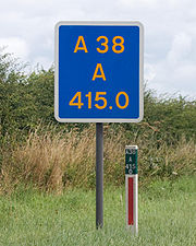
at a junction with the A30
A30 road
The 284 miles A30 road from London to Land's End, historically known as the Great South West Road used to provide the most direct route from London to the south west; more recently the M3 motorway and A303 road performs this function for much of the route and only parts of A30 now retain trunk...
before traversing the edge of the town to meet the A30 again. It travels through the picturesque Glynn Valley to Dobwalls
Dobwalls
Dobwalls is a village in south-east Cornwall, United Kingdom. It is situated three miles west of Liskeard.The name is spelt Dubwalls on Bartholomew's map and Black's Guide of 1879....
and Liskeard
Liskeard
Liskeard is an ancient stannary and market town and civil parish in south east Cornwall, England, United Kingdom.Liskeard is situated approximately 20 miles west of Plymouth, west of the River Tamar and the border with Devon, and 12 miles east of Bodmin...
, which are bypassed by a dual carriageway
Dual carriageway
A dual carriageway is a class of highway with two carriageways for traffic travelling in opposite directions separated by a central reservation...
. The Dobwalls section contains the most sophisticated bat bridge
Bat bridge
A bat bridge is a structure of varying construction crossing a new or altered road to aid the navigation of bats following the destruction of a hedgerow, and to cause the bats to cross the roadway at a sufficient height to avoid traffic...
yet constructed in the UK. The A38 continues through the Cornish countryside, bypassing the centre of Saltash
Saltash
Saltash is a town and civil parish in Cornwall, England, United Kingdom. It has a population of 14,964. It lies in the south east of Cornwall, facing Plymouth over the River Tamar. It was in the Caradon district until March 2009 and is known as "the gateway to Cornwall". Saltash means ash tree by...
and continuing through the Saltash Tunnel
Saltash Tunnel
The Saltash Tunnel is a road tunnel on the A38 at Saltash in Cornwall, UK and was opened in 1988.The central lane operates as a reversible lane to cope with holiday and rush hour traffic and the speed limit is 30 mph. The tunnel is used by more than 38,000 motorists per day and is 410 m long...
. Immediately after the tunnel the River Tamar
River Tamar
The Tamar is a river in South West England, that forms most of the border between Devon and Cornwall . It is one of several British rivers whose ancient name is assumed to be derived from a prehistoric river word apparently meaning "dark flowing" and which it shares with the River Thames.The...
is crossed using the Tamar Bridge
Tamar Bridge
The Tamar Bridge is a major road bridge at Saltash in southwest England carrying traffic between Cornwall and Devon. When it opened in 1961 it was the longest suspension bridge in the United Kingdom...
where the route resumes dual carriageway status. The section from Plymouth to Exeter is called the 'Devon Expressway', it forms the southern border of Dartmoor National Park
Dartmoor
Dartmoor is an area of moorland in south Devon, England. Protected by National Park status, it covers .The granite upland dates from the Carboniferous period of geological history. The moorland is capped with many exposed granite hilltops known as tors, providing habitats for Dartmoor wildlife. The...
, and serves as a southward extension of the M5 motorway
M5 motorway
The M5 is a motorway in England. It runs from a junction with the M6 at West Bromwich near Birmingham to Exeter in Devon. Heading south-west, the M5 runs east of West Bromwich and west of Birmingham through Sandwell Valley...
opening in 1977.. It is 42 miles (67.6 km) long and was completed in the early 1970s. There are several grade separated junctions
Grade separation
Grade separation is the method of aligning a junction of two or more transport axes at different heights so that they will not disrupt the traffic flow on other transit routes when they cross each other. The composition of such transport axes does not have to be uniform; it can consist of a...
along its length mainly for local traffic; including a three-level stacked roundabout
Roundabout
A roundabout is the name for a road junction in which traffic moves in one direction around a central island. The word dates from the early 20th century. Roundabouts are common in many countries around the world...
for the A386, which heads out towards Dartmoor
Dartmoor
Dartmoor is an area of moorland in south Devon, England. Protected by National Park status, it covers .The granite upland dates from the Carboniferous period of geological history. The moorland is capped with many exposed granite hilltops known as tors, providing habitats for Dartmoor wildlife. The...
National Park. The route was reserved for the Parkway as early as 1943, when it was included in the Plan for Plymouth. In the early 1990s, the Marsh Mills junction was significantly remodelled, reducing the size of the roundabout and building a flyover over the top of it, allowing free flowing access from the Plympton bypass onto the Parkway. The viaducts carrying the A38 over the River Plym
River Plym
The River Plym is a river in Devon, England. Its source is some 450m above sea level on Dartmoor, in an upland marshy area called Plym Head. From the upper reaches which contain antiquities and mining remains the river flows roughly southwest and enters the sea near to the city of Plymouth, where...
, which after the construction of the Marsh Mills flyover became the Exeter bound sliproads, were built in 1969-1970 as part of the Plympton bypass. They were replaced in the 1990s due to suffering from Alkali Silica Reaction
Alkali Silica Reaction
The alkali–silica reaction is a reaction which occurs over time in concrete between the highly alkaline cement paste and reactive non-crystalline silica, which is found in many common aggregates....
, and the project, completed in February 1996 at a cost of £12.25million, involved the world's largest sideways bridge slide at the time for the 410 metres (1,345.1 ft), 5,500 tonne bridge. This required the road to be closed for only 48 hours, which won it an AA
The Automobile Association
The Automobile Association , a British motoring association founded in 1905 was demutualised in 1999 to become a private limited company which currently provides car insurance, driving lessons, breakdown cover, loans and motoring advice, and other services...
National Motoring Award in 1996 for innovation and minimisation of traffic congestion.
The South Brent
South Brent
South Brent is a large village on the southern edge of Dartmoor, England, in the valley of the River Avon, population 2998 , 8 km north-east of Ivybridge, and next to the Devon Expressway which connects Exeter to the north-east and Plymouth to the west.-History:It was originally a woollen...
bypass opened in 1974 and the Ivybridge
Ivybridge
Ivybridge is a small town and civil parish in the South Hams, in Devon, England. It lies about east of Plymouth. It is at the southern extremity of Dartmoor, a National Park of England and Wales and lies along the A38 "Devon Expressway" road...
bypass in 1973, both on new alignments. The A38 passes Endsleigh Garden Centre, which used to have direct access from the dual carriageway, although since the early 2000s this has been closed and the garden centre is accessed from the Westover junction for Ivybridge. After Ivybridge, the route roughly parallels the original route, bypassing the village of Lee Mill which is now home to a large trading estate. The road widens to a three-lane dual carriageway for the Plympton
Plympton
Plympton, or Plympton Maurice or Plympton St Maurice or Plympton St Mary or Plympton Erle, in south-western Devon, England is an ancient stannary town: an important trading centre in the past for locally mined tin, and a former seaport...
bypass. This opened in 1971 and was the first section of the Devon Expressway to built on a new alignment, as well as being the first sizeable dual carriageway section of the route. The route originally ended at the Marsh Mills roundabout, which when opened was the largest in Europe.
The section of the A38 between the A382 junction and Ashburton
Ashburton, Devon
Ashburton is a small town on the edge of Dartmoor in Devon, adjacent to the A38 Devon Expressway.It was formerly important as a stannary town , and remains the largest town within the National Park, with a population of around 3,500...
was built on a new alignment parallel to the old road, and was opened in 1974. Trago Mills
Trago Mills
Trago Mills is a chain of British department stores situated in the West Country. They are sited in the town of Falmouth, and on the outskirts of two other towns at Liskeard, Cornwall and Newton Abbot, Devon. Large department stores were formerly sparse in the rural west country and Trago Mills has...
, a locally well known furniture store and leisure centre, is passed by the road. The Ashburton bypass, much like the Kennford bypass, uses the alignment of a much older 1930s single carriageway bypass, which was subsequently upgraded to dual carriageway by 1974. At the village of Buckfastleigh
Buckfastleigh
Buckfastleigh is a small market town and civil parish in Devon, England situated beside the Devon Expressway at the edge of the Dartmoor National Park. It is part of Teignbridge District and, for ecclesiastical purposes lies within the Totnes Deanery. It has a population of 3,661...
, the route once again bypasses on a new alignment, although due to the challenging topography of the area, the road crosses part of the village on a viaduct. From Buckfastleigh to the A385 junction, the current road follows the route of original single carriageway, with the majority of this section being upgraded between 1973 and 1974, although a small section at Dean Prior was upgraded between 1966 and 1967. This section is of a poor quality when compared to the majority of the route between Exeter and Plymouth, containing several side turnings with short exit/entry slips, and properties which back onto the road.
Chudleigh
Chudleigh is a small town in Devon, England located between the towns of Newton Abbot and Exeter.Chudleigh is very close to the edge of Dartmoor and bypassed by the A38 road in 1972. It began life as a small wool market town, though the nearby Castle Dyke is an Iron Age Hill Fort which demonstrates...
and the village of Chudleigh Knighton
Chudleigh Knighton
Chudleigh Knighton is a small village in Devon, England, near to Newton Abbot and Bovey Tracey.-Amenities:Chudleigh Knighton Church of England Primary School currently has around 80 pupils, aged 5 to 11. The school has 4 classrooms spread over 2 floors....
are bypassed on a new alignment, which opened in 1973, and the following section at Heathfield up to the A382 junction was upgraded from the original route between 1966 and 1968. Some of this section follows part of the old Teign Valley Line
Teign Valley Line
The Teign Valley Line was a single track railway line that ran from Heathfield, Devon to Exeter via the Teign Valley. Its main stations were at , Christow and Ide, and it joined the South Devon main line at Exeter City Basin Junction.-History:...
railway.
Before Kennford, the route splits, with the A38 heading for Plymouth and the A380
A380 road
The A380 is a road in South West England, connecting the Torbay area to the A38, and hence to the rest of Great Britain's main road network.-Route:...
heading towards Torbay
Torbay
Torbay is an east-facing bay and natural harbour, at the western most end of Lyme Bay in the south-west of England, situated roughly midway between the cities of Exeter and Plymouth. Part of the ceremonial county of Devon, Torbay was made a unitary authority on 1 April 1998...
. At this point, the road becomes a dual two-lane road although a third-lane emerges immediately for uphill traffic as the route climbs Haldon Hill
Haldon
The Haldon Hills, usually known simply as Haldon, is a ridge of high ground in Devon, England. It is situated between the River Exe and the River Teign and runs northwards from Teignmouth, on the coast, for about until it dwindles away north west of Exeter at the River Yeo, just south of Crediton...
, which has an average gradient of 1 in 20 over a 4 km distance, and a maximum gradient of around 1 in 10 (the adjacent A380 Telegraph Hill has about the same maximum gradient). The third lane is lost at the top of the hill, and the next section, the Harcombe bends is an original dual carriageway section, older than the rest of the route and this is evident with its sharp bends.
The Devon Expressway ends near the village of Kennford
Kennford
Kennford is a village situated in Devon, England, several miles to the south of Exeter, in one of the country's main tourist areas.The village became prominent in the 1970s as the location of a new service station on the A38 Devon Expressway between Exeter and Plymouth, near the southern terminus...
, south of Exeter, at the terminus of the M5. This initial section was opened in 1977, along with the remaining section of the M5, and is a three-lane dual carriageway. The village of Kennford is bypassed, on an alignment of a 1930s bypass, which was upgraded to dual carriageway in the 1960s and then widened to a dual three-lane road in 1975.
A junction to the south of Exeter
Exeter
Exeter is a historic city in Devon, England. It lies within the ceremonial county of Devon, of which it is the county town as well as the home of Devon County Council. Currently the administrative area has the status of a non-metropolitan district, and is therefore under the administration of the...
represents a third meeting point of the A38 with the A30, from which point the A38 multiplexes
Concurrency (road)
A concurrency, overlap, or coincidence in a road network is an instance of one physical road bearing two or more different highway, motorway, or other route numbers...
with the M5 before re-emerging from junction 27 near Waterloo Cross, 21 miles (33.8 km) north of Exeter. From junction 27 the A38 heads north via Wellington
Wellington, Somerset
Wellington is a small industrial town in rural Somerset, England, situated south west of Taunton in the Taunton Deane district, near the border with Devon, which runs along the Blackdown Hills to the south of the town...
, Taunton
Taunton
Taunton is the county town of Somerset, England. The town, including its suburbs, had an estimated population of 61,400 in 2001. It is the largest town in the shire county of Somerset....
, Bridgwater
Bridgwater
Bridgwater is a market town and civil parish in Somerset, England. It is the administrative centre of the Sedgemoor district, and a major industrial centre. Bridgwater is located on the major communication routes through South West England...
, Highbridge
Highbridge, Somerset
Highbridge is a small market town situated on the edge of the Somerset Levels near the mouth of the River Brue. It is in the County of Somerset, and is approximately north west of Taunton, the county town of Somerset. Highbridge is in the District of Sedgemoor, being situated approximately north...
and Bristol
Bristol
Bristol is a city, unitary authority area and ceremonial county in South West England, with an estimated population of 433,100 for the unitary authority in 2009, and a surrounding Larger Urban Zone with an estimated 1,070,000 residents in 2007...
. From Waterloo Cross to Birmingham, the road is paralleled by the M5, where the A38 has reverted to taking local traffic only.
From Bristol, it continues north via Gloucester
Gloucester
Gloucester is a city, district and county town of Gloucestershire in the South West region of England. Gloucester lies close to the Welsh border, and on the River Severn, approximately north-east of Bristol, and south-southwest of Birmingham....
, Tewkesbury
Tewkesbury
Tewkesbury is a town in Gloucestershire, England. It stands at the confluence of the River Severn and the River Avon, and also minor tributaries the Swilgate and Carrant Brook...
, Worcester
Worcester
The City of Worcester, commonly known as Worcester, , is a city and county town of Worcestershire in the West Midlands of England. Worcester is situated some southwest of Birmingham and north of Gloucester, and has an approximate population of 94,000 people. The River Severn runs through the...
and Bromsgrove
Bromsgrove
Bromsgrove is a town in Worcestershire, England. The town is about north east of Worcester and south west of Birmingham city centre. It had a population of 29,237 in 2001 with a small ethnic minority and is in Bromsgrove District.- History :Bromsgrove is first documented in the early 9th century...
to Birmingham
Birmingham
Birmingham is a city and metropolitan borough in the West Midlands of England. It is the most populous British city outside the capital London, with a population of 1,036,900 , and lies at the heart of the West Midlands conurbation, the second most populous urban area in the United Kingdom with a...
. Between Worcester and Birmingham the A38 followed the line of an identified Saxon Salt road
Salt Road
A salt road ) is any of the prehistoric and historical trade routes by which essential salt has been transported to regions that lacked it ....
, one of six leading out of Droitwich. At Bromsgrove, it meets the M42
M42 motorway
The M42 motorway is a major road in England. The motorway runs north east from Bromsgrove in Worcestershire to just south west of Ashby-de-la-Zouch in Leicestershire, passing Redditch, Solihull, the National Exhibition Centre and Tamworth on the way. The section between the M40 and M6 road forms...
and the B4096 at junction 1 at Lickey End
Lickey End
Lickey End is a village in the Bromsgrove District of Worcestershire, England. It is situated just north of Bromsgrove, to the south-east of the junction of the A38 Birmingham Road and the M42 motorway, and has a population of 2,764. The Old Birmingham Road goes north out of the village, passing...
.
Catshill
Not to be confused with Catshill, WalsallCatshill is a village in Worcestershire about 2.5 miles north of Bromsgrove and 10 miles south-west of Birmingham. The parish of Catshill was formed around the Turnpike Road in 1844....
and meets the M5
M5 motorway
The M5 is a motorway in England. It runs from a junction with the M6 at West Bromwich near Birmingham to Exeter in Devon. Heading south-west, the M5 runs east of West Bromwich and west of Birmingham through Sandwell Valley...
at junction 4 near Lydiate Ash
Lydiate Ash
Lydiate Ash is a hamlet, consisting of a few houses and the road gritting depot for Bromsgrove District Council.area of North Worcestershire, England. It is in the district of Bromsgrove, to the south-west of Birmingham....
. From here to Edgbaston
Edgbaston
Edgbaston is an area in the city of Birmingham in England. It is also a formal district, managed by its own district committee. The constituency includes the smaller Edgbaston ward and the wards of Bartley Green, Harborne and Quinton....
, the road is mostly dual carriageway, single-lane sections having been replaced in the first decade of the 21st century (see history section, below).
In the centre of Birmingham, a section of the road becomes the Aston Expressway A38(M) motorway
A38(M) motorway
The A38, also known as the Aston Expressway, is a motorway in Birmingham, England. It is long and was opened on 24 May 1972. It forms part of the much longer A38 route....
, running from the north-eastern side of the Inner Ring Road
A4540 road
The A4540 is a Ring Road in Birmingham, England, also known as the Middle Ring Road, or the Middleway. There are proposals to make it a red route. It runs around the centre of the city at a distance of approximately . Birmingham City Centre is the area within this ring road. The ring road was...
through Aston
Aston
Aston is an area of the City of Birmingham, in the West Midlands of England. Lying to the north-east of the Birmingham city centre, Aston constitutes an electoral ward within the council constituency of Ladywood.-History:...
to the junction with the M6 motorway
M6 motorway
The M6 motorway runs from junction 19 of the M1 at the Catthorpe Interchange, near Rugby via Birmingham then heads north, passing Stoke-on-Trent, Manchester, Preston, Carlisle and terminating at the Gretna junction . Here, just short of the Scottish border it becomes the A74 which continues to...
at Gravelly Hill Interchange
Gravelly Hill Interchange
Gravelly Hill Interchange, better known by its nickname Spaghetti Junction, is junction 6 of the M6 motorway where it meets the A38 Aston Expressway in Birmingham, England.- Overview :...
, better known as Spaghetti Junction.
The West Midlands section of the A38 is one of the areas chosen by the Highways Agency
Highways Agency
The Highways Agency is an executive agency, part of the Department for Transport in England. It has responsibility for managing the core road network in England...
to monitor the effectiveness of driver location signs
Driver location signs
Driver location signs are English highway route markers, first introduced in 2003, that complement distance marker posts. Both types of marker post display the distances from a nominal start point in kilometres...
in assisting motorists to communicate their location to the emergency services.
Birmingham to Mansfield
From Birmingham the road bypasses Sutton ColdfieldSutton Coldfield
Sutton Coldfield is a suburb of Birmingham, in the West Midlands of England. Sutton is located about from central Birmingham but has borders with Erdington and Kingstanding. Sutton is in the northeast of Birmingham, with a population of 105,000 recorded in the 2001 census...
and Lichfield
Lichfield
Lichfield is a cathedral city, civil parish and district in Staffordshire, England. One of eight civil parishes with city status in England, Lichfield is situated roughly north of Birmingham...
, before taking up the route of the Roman road, Ryknild Street
Icknield Street
Icknield Street or Ryknild Street is a Roman road in Britain that runs from the Fosse Way at Bourton on the Water in Gloucestershire to Templeborough in South Yorkshire...
, (also spelt Icknield or Rykneld), as far as Derby
Derby
Derby , is a city and unitary authority in the East Midlands region of England. It lies upon the banks of the River Derwent and is located in the south of the ceremonial county of Derbyshire. In the 2001 census, the population of the city was 233,700, whilst that of the Derby Urban Area was 229,407...
. At Wychnor
Wychnor
Wychnor is a civil parish in Staffordshire, England, situated in the East Staffordshire local government district adjoining Alrewas and Barton-under-Needwood. It is situated on the A38, formerly the Roman road Ryknild Street, and contains the hamlet of Wychnor Bridges where the A38 crosses the...
, the road crosses the River Trent
River Trent
The River Trent is one of the major rivers of England. Its source is in Staffordshire on the southern edge of Biddulph Moor. It flows through the Midlands until it joins the River Ouse at Trent Falls to form the Humber Estuary, which empties into the North Sea below Hull and Immingham.The Trent...
and enters the district of East Staffordshire
East Staffordshire
East Staffordshire is a local government district with borough status in Staffordshire in England. It has two main towns, Burton upon Trent, famous for its breweries, and Uttoxeter, for its racecourse....
. At Barton Turn, near the B5016 junction, the road runs right alongside the Cross Country Route for around 1 miles (1.6 km). This railway line follows the line of the A38 from Derby to Plymouth. From Alrewas to Burton, the path called The Way for the Millennium follows the northbound carriageway.
From Clay Mills, the road passes through the district of South Derbyshire
South Derbyshire
South Derbyshire is a local government district in Derbyshire, England. It contains a third of the National Forest, and the council offices are in Swadlincote....
, passing the grade separated junction with the A5132 for Willington
Willington, Derbyshire
Willington is a village and civil parish in South Derbyshire, England. The 2001 Census recorded a parish population of 2,604.-Geography:Willington is on the River Trent about southwest of Derby...
. There is the Derby with Burton services at the Burnaston
Burnaston
Burnaston is a village located in Derbyshire, just south of the city of Derby.The village is famous for its huge Toyota car plant - one of several British car plants built by Japanese carmakers as part of cost-saving measures to avoid such expenses as import duties and shipping costs...
A50
A50 road
The A50 is a major trunk road in England. It runs from Warrington to Leicester; however, it was once a much longer route.-Current route:...
interchange. The road enters the City of Derby borough 0.5 mile (0.80467 km) north of the Littleover
Littleover
Littleover is a large suburb of Derby, England situated between Rose Hill, Normanton, Sunny Hill, South Derbyshire and Mickleover about three miles south west of Derby city centre.-History:The history of the name of Littleover is simple...
interchange. For nearly 4 miles (6.4 km), the A38 forms part of Derby's outer ring road, including three roundabouts: Kingsway (or Grand Canyon) for the A5111; Markeaton
Markeaton
Markeaton is a village within Derby in the East Midlands of England.The name possibly means Boundary - Island Village, which had stood at this site since Medieval times....
for the A52
A52 road
The A52 is a major road in the East Midlands, England. It runs east from the junction with the A53 at Newcastle-under-Lyme near Stoke-on-Trent via Ashbourne, Derby, Stapleford, Nottingham, West Bridgford, Bingham, Grantham, Boston and Skegness before terminating on the east Lincolnshire coast at...
; and Little Eaton
Little Eaton
Little Eaton is a village in the English county of Derbyshire. The name originated from Anglo Saxon times and means the little town by the water....
(or Abbey Hill) for the A61 and B6179. The section of road between Kingsway roundabout to just north of Markeaton is urban in nature and thus subject to a 40 mi/h speed limit.
Originally terminating in Derby at the junction of Babington Lane with St Peter's Street (formerly the A6), The road enters the district of Amber Valley where it passes Drum Hill just north of Little Eaton and is crossed at this point by the Midshires Way
Midshires Way
The Midshires Way is a long distance footpath and bridleway that runs for through Middle England from Bledlow in Buckinghamshire to Stockport, Greater Manchester....
and Centenary Way. There is a junction for the B6179 to Ripley and Belper
Belper
Belper is a town and civil parish in the local government district of Amber Valley in Derbyshire, England.-Geography:Belper is situated eight miles north of Derby and is centred in the valley of the River Derwent...
. At Alfreton, there is a grade separated junction with the A61, A615 and B6179. The section from Alfreton to the M1, the Alfreton-South Normanton
South Normanton
South Normanton is a medium-sized ex-mining village two miles east of Alfreton, Derbyshire and is approximately 155 metres above sea level at one of the highest points, near St...
Bypass, opened as the A615 in the late 1960s. This section has a grade separated junction with the B600 for Somercotes
Somercotes
Somercotes is a village and Parish in the District of Amber Valley in the English county of Derbyshire, close to the border with Nottinghamshire. It is a former mining village and was once surrounded by more than five pits. It is now one of the fastest developing villages in the Amber Valley area,...
and the Cotes Park industrial estate, and where it crosses the Nottingham spur of the Midland Main Line
Midland Main Line
The Midland Main Line is a major railway route in the United Kingdom, part of the British railway system.The present-day line links London St...
it enters the district of Bolsover
Bolsover (district)
Bolsover is a local government district in Derbyshire, England. Its main town is Bolsover.There are fourteen town and parish councils within the district.In addition to the town councils of Old Bolsover and Shirebrook, there are the parish councils of:...
.
As a 1970s upgrade to the route of the A61 north of Derby (which became the B6179), the A38 bypasses Ripley
Ripley, Derbyshire
Ripley is a town in the Amber Valley area of Derbyshire in England.- Earliest history :Not much information is available as to when Ripley was founded, but it existed at the time of the Domesday Book, when it was held by a man called Levenot....
passing through former opencast mining land, before joining end-on with the former A615 Alfreton bypass at Watchorn Intersection. The road crosses the M1
M1 motorway
The M1 is a north–south motorway in England primarily connecting London to Leeds, where it joins the A1 near Aberford. While the M1 is considered to be the first inter-urban motorway to be completed in the United Kingdom, the first road to be built to motorway standard in the country was the...
at junction 28. Into Nottinghamshire
Nottinghamshire
Nottinghamshire is a county in the East Midlands of England, bordering South Yorkshire to the north-west, Lincolnshire to the east, Leicestershire to the south, and Derbyshire to the west...
, the road bypasses Sutton-in-Ashfield
Sutton-in-Ashfield
Sutton-in-Ashfield is a market town in the Ashfield district of Nottinghamshire, England, with a population of around 43,000. It is situated four miles west of Mansfield, close to the Derbyshire border.-Geography:...
, dropping to a single carriageway configuration of 1980s construction, including multiple traffic light controlled junctions – such as the Mansfield, Ashfield Regeneration Route ("MARR"). The final section of the A38 from Sutton, past King's Mill Hospital
King's Mill Hospital
King's Mill Hospital is a hospital situated in Sutton-in-Ashfield, UK. The Hospital serves the towns in the Mansfield Urban Area....
into Mansfield
Mansfield
Mansfield is a town in Nottinghamshire, England. It is the main town in the Mansfield local government district. Mansfield is a part of the Mansfield Urban Area....
, is purely urban in nature and is single carriageway, joining the A6009 in Mansfield Town Centre at the end of the route from Cornwall to the North Midlands.
History
When first designated in 1922, the A38 ran from the centre of Plymouth to Derby. It was later extended west from Plymouth on the former route of the A389 over the Torpoint FerryTorpoint Ferry
The Torpoint Ferry is a car and pedestrian chain ferry, connecting the A374 road which crosses the Hamoaze, a stretch of water at the mouth of the River Tamar, between Devonport in Plymouth and Torpoint in Cornwall...
to a junction with the A30 at Bodmin. When the Tamar Bridge was opened in 1961, the A38 was rerouted on the former line of the A374
A374 road
The A374 is a main road in the United Kingdom, one of six A-roads making the border crossing between Devon and Cornwall. It is the most southerly of the A37x group of roads, starting and ending its journey with the A38 trunk road, from the outskirts of Plymouth in Devon to the Trerulefoot...
, through Tideford, over the new bridge and through Crownhill
Crownhill
Crownhill is an area of northern Plymouth, in the English county of Devon.-Overview:It was originally known as Knackersknowle, meaning "the hill of the knacker's yard". In 1860 a fort was built on a high piece of land, just to the north west of the village, on the site of a building called Crown...
, joining the old route at Plympton. The old route of the A38, via Torpoint and the centre of Plymouth, was redesignated the A374.
The A38 was extended north from Derby to the M1 motorway and Mansfield in 1977, partly on the former line of the A615.
Cornwall
The LiskeardLiskeard
Liskeard is an ancient stannary and market town and civil parish in south east Cornwall, England, United Kingdom.Liskeard is situated approximately 20 miles west of Plymouth, west of the River Tamar and the border with Devon, and 12 miles east of Bodmin...
bypass, stretching for 6 miles (10 km) from the west of Liskeard to Trerulefoot
Trerulefoot
Trerulefoot is a village in southeast Cornwall, United Kingdom. It is located on the A38 trunk road approximately half-way between the towns of Saltash and Liskeard. Trerulefoot has a farm shop, two cafés and a petrol filling station....
, opened in June 1976.
A public inquiry was held for the Dobwalls
Dobwalls
Dobwalls is a village in south-east Cornwall, United Kingdom. It is situated three miles west of Liskeard.The name is spelt Dubwalls on Bartholomew's map and Black's Guide of 1879....
bypass in February 2005, which was expected to cost £32 million. The bottleneck was removed when the bypass, linking the existing Liskeard bypass to the current single carriageway section through the Glynn Valley opened in the Winter of 2008. A campaign to open this road was started by villagers in Dobwalls in 1930, but planning for building the road was not granted until 2006, the work starting on 15 November that year.
In a separate improvement within the Glynn Valley, the Highways Agency
Highways Agency
The Highways Agency is an executive agency, part of the Department for Transport in England. It has responsibility for managing the core road network in England...
stabilised a 840 metre (0.521953098785838 mi) section of the road near Bodmin Parkway railway station
Bodmin Parkway railway station
Bodmin Parkway railway station is a station on the Cornish Main Line and serves the nearby town of Bodmin, Cornwall, United Kingdom. The station is west of , in the civil parish of St Winnow....
. The work, which commenced in October 2007, was carried out to shore-up the verge which had been built on an embankment
Embankment (transportation)
To keep a road or railway line straight or flat, and where the comparative cost or practicality of alternate solutions is prohibitive, the land over which the road or rail line will travel is built up to form an embankment. An embankment is therefore in some sense the opposite of a cutting, and...
supported by dry stone walling and the root systems of large trees. It was completed in May 2008 seeing the installation of kerbing, road drainage gulleys, safety barriers as well as increasing the verge width to allow for a new surface water drainage system.
Devon
The A38 in Devon runs between Tamar BridgeTamar Bridge
The Tamar Bridge is a major road bridge at Saltash in southwest England carrying traffic between Cornwall and Devon. When it opened in 1961 it was the longest suspension bridge in the United Kingdom...
outside Plymouth and junction 31 of the M5, where the motorway ends; this section is known as the Devon Expressway. It is mainly a two-lane dual carriageway which runs between Exeter
Exeter
Exeter is a historic city in Devon, England. It lies within the ceremonial county of Devon, of which it is the county town as well as the home of Devon County Council. Currently the administrative area has the status of a non-metropolitan district, and is therefore under the administration of the...
and Plymouth
Plymouth
Plymouth is a city and unitary authority area on the coast of Devon, England, about south-west of London. It is built between the mouths of the rivers Plym to the east and Tamar to the west, where they join Plymouth Sound...
serving as a continuation of the M5 motorway. It is a common route for tourists travelling to Cornwall
Cornwall
Cornwall is a unitary authority and ceremonial county of England, within the United Kingdom. It is bordered to the north and west by the Celtic Sea, to the south by the English Channel, and to the east by the county of Devon, over the River Tamar. Cornwall has a population of , and covers an area of...
, though those wanting to use a continuous dual carriageway route to Cornwall can use the A30
A30 road
The 284 miles A30 road from London to Land's End, historically known as the Great South West Road used to provide the most direct route from London to the south west; more recently the M3 motorway and A303 road performs this function for much of the route and only parts of A30 now retain trunk...
rather than the Devon Expressway. It then runs concurrently with the M5 until junction 27, where it splits and enters Somerset independent but parallel to the M5.
During the mid 1960s, small sections of the route between Plymouth and Exeter were upgraded to dual carriageway, such as those at Dean Prior and Heathfield. This was followed by the construction of Plympton bypass in 1970-71, with the majority of realignment, such as the Ivybridge and Buckfastleigh bypasses, being completed during 1973-74. The route, now known as the Devon Expressway, was largely complete by 1975, with the final section between Kennford and the M5 opening in 1977, coinciding with the completion of the M5 during the same year. Whilst many of the sections were newly constructed realignments, some sections such as the Ashburton and Kennford bypasses were upgraded from the original 1930s single carriageway bypasses. The Parkway, the section of dual carriageway through the suburbs of Plymouth between the Tamar Bridge and Marsh Mills, was constructed in 1983-84, along a route which had been reserved for this road since 1943. This was followed by the construction of a flyover over Marsh Mills roundabout in 1992, providing a non stop route between the Plympton bypass and the Parkway.
The Plympton bypass was used for a stage in the 1974 Tour de France
1974 Tour de France
The 1974 Tour de France was the 61st Tour de France, taking place June 27 to July 21, 1974. It consisted of 22 stages over 4098 km, ridden at an average speed of 35.241 km/h...
, the first time the race
Tour de France
The Tour de France is an annual bicycle race held in France and nearby countries. First staged in 1903, the race covers more than and lasts three weeks. As the best known and most prestigious of cycling's three "Grand Tours", the Tour de France attracts riders and teams from around the world. The...
had ever come to the United Kingdom. Popular belief is held that the Plympton bypass was newly completed, but had not yet opened. In fact, the Plympton bypass had been open some three years earlier.
The viaducts carrying the A38 over the River Plym
River Plym
The River Plym is a river in Devon, England. Its source is some 450m above sea level on Dartmoor, in an upland marshy area called Plym Head. From the upper reaches which contain antiquities and mining remains the river flows roughly southwest and enters the sea near to the city of Plymouth, where...
, which after the construction of the Marsh Mills flyover became the Exeter bound sliproads, were built in 1969-1970 as part of the Plympton bypass. They were replaced in the 1990s due to suffering from Alkali Silica Reaction
Alkali Silica Reaction
The alkali–silica reaction is a reaction which occurs over time in concrete between the highly alkaline cement paste and reactive non-crystalline silica, which is found in many common aggregates....
, and the project, completed in February 1996 at a cost of £12.25million, involved the world's largest sideways bridge slide at the time for the 410 metres (1,345.1 ft), 5,500 tonne bridge. This required the road to be closed for only 48 hours, winning it an AA
The Automobile Association
The Automobile Association , a British motoring association founded in 1905 was demutualised in 1999 to become a private limited company which currently provides car insurance, driving lessons, breakdown cover, loans and motoring advice, and other services...
National Motoring Award in 1996 for innovation and minimisation of traffic congestion.
As with any major road, accidents are likely to occur; however due to the substandard design of some sections of the route between Exeter and Plymouth, the accident rate has been identified as being above the national average for the type of road. A spate of accidents in April 2009 heightened local awareness of the issue, with local MP Gary Streeter
Gary Streeter
Gary Nicholas Streeter is a Conservative Party politician in the United Kingdom. From 1997 he was Member of Parliament for South West Devon, having previously been the Member of Parliament for Plymouth Sutton between 1992 and 1997...
calling for a review of the road. A number of improvements have been made along the route in recent years, mainly being the replacement of worn-out road surfaces, such as those at Buckfastleigh and Ivybridge. These projects have also included the replacement of signage, and the reconstruction of exit/entry slips for side turnings, in a bid to make the road safer.
Presently, the route between Plymouth and the end of M5 is all dual carriageway, and branded the Devon Expressway, being the primary route that links Plymouth to the rest of the country.
Beyond the end of M5, the road runs concurrently with and as the M5 until junction 27. The original route between Exeter and junction 27 of the M5 (Waterloo Cross) was downgraded to become the B3181 when the M5 was opened in 1977
Somerset
From Junction 27 of the M5 to East BrentEast Brent, Somerset
East Brent is a village and civil parish, located on the eastern edge of a hill that dominates the surrounding level countryside—Brent Knoll—close to the M5 motorway, west of Axbridge, in the Sedgemoor district of the county of Somerset, in the south-west of England...
, the A38 runs broadly parallel to the motorway: junctions 22 to 27 are mostly spurs connecting to the road and all no further than 1.5 miles (2.4 km) from it. The A38 runs around Wellington
Wellington, Somerset
Wellington is a small industrial town in rural Somerset, England, situated south west of Taunton in the Taunton Deane district, near the border with Devon, which runs along the Blackdown Hills to the south of the town...
, through the county seat of Taunton
Taunton
Taunton is the county town of Somerset, England. The town, including its suburbs, had an estimated population of 61,400 in 2001. It is the largest town in the shire county of Somerset....
, North Petherton
North Petherton
North Petherton is a small town and civil parish in Somerset, England, situated on the edge of the eastern foothills of the Quantocks, and close to the edge of the Somerset Levels.The town has a population of 5,189...
and Highbridge
Highbridge, Somerset
Highbridge is a small market town situated on the edge of the Somerset Levels near the mouth of the River Brue. It is in the County of Somerset, and is approximately north west of Taunton, the county town of Somerset. Highbridge is in the District of Sedgemoor, being situated approximately north...
. Beyond Highbridge and junction 22, the road departs the motorway and resumes primary status, going through Winscombe
Winscombe
Winscombe is a village in North Somerset, England, close to the settlements of Axbridge and Cheddar, on the western edge of the Mendip Hills, south-east of Weston-super-Mare and south-west of Bristol...
and Lower Langford
Lower Langford
Lower Langford is a village within the civil parish of Churchill in the unitary authority of North Somerset, England. It is located on the western edge of the Mendip Hills about east of Weston-super-Mare. It was a village built around estate of Sidney Hill who was the original inhabitant of the...
. This route is the suggested route for accessing the south of Bristol and Bristol Airport
Bristol Airport
Bristol Airport may refer to:* Bristol Airport, serving Bristol, England, United Kingdom ** Bristol Airport , a docu-soap based on events at Bristol Airport...
from the South West.
The centre of Bridgwater
Bridgwater
Bridgwater is a market town and civil parish in Somerset, England. It is the administrative centre of the Sedgemoor district, and a major industrial centre. Bridgwater is located on the major communication routes through South West England...
was a notorious bottle neck on the "holiday route" as traffic from both the A38 and the A39
A39 road
The A39 is an A road in south west England. It runs south-west from Bath in Somerset through Wells, Glastonbury, Street and Bridgwater. It then follows the north coast of Somerset and Devon through Williton, Minehead, Porlock, Lynmouth, Barnstaple, Bideford, Stratton, Camelford, Wadebridge and St...
had to negotiate through the town centre in order to cross the River Parrett
River Parrett
The River Parrett flows through the counties of Dorset and Somerset in South West England, from its source in the Thorney Mills springs in the hills around Chedington in Dorset...
. The construction of a new reinforced concrete road bridge, the Blake Bridge, which opened in March 1958 as part of a southern bypass took much of the traffic away from the centre of Bridgwater. The opening of the M5 in 1974 further reduced the traffic pressure. This is complemented by a link road (Western Way) linking the A38 and the A39 north and west of the town respectively.
Much of the A38 through Somerset was built as single carriageway, with some three-lane passing points. However, the construction of the M5 through Somerset, in the early 1970s, led to the building of links between the A38 and the M5 in the form of new roundabouts on the A38 linking into adjacent junctions on the M5.
Greater Bristol area
The A38 serves Bristol AirportBristol Airport
Bristol Airport may refer to:* Bristol Airport, serving Bristol, England, United Kingdom ** Bristol Airport , a docu-soap based on events at Bristol Airport...
to the south west of the city, and enters the city itself at Highridge, along Bedminster Down
Bishopsworth
Bishopsworth is the name of both a council ward of the city of Bristol in the United Kingdom, and a suburb of the city which lies within that ward.As well as the suburb of Bishopsworth, the ward contains the areas of Bedminster Down, Highridge and Withywood....
and into Bedminster. It runs through central Bristol
Bristol
Bristol is a city, unitary authority area and ceremonial county in South West England, with an estimated population of 433,100 for the unitary authority in 2009, and a surrounding Larger Urban Zone with an estimated 1,070,000 residents in 2007...
before leaving northwards through Stokes Croft
Stokes Croft
Stokes Croft is the name of a road and an area in Bristol, England. The road forms part of the A38 that leads north from the city centre, before it takes the names Cheltenham Road and then Gloucester Road...
and along Gloucester Road
Gloucester Road, Bristol
Gloucester Road, is a part of the A38 in north Bristol that runs through the suburbs of St. Andrews, Bishopston and Horfield. It was originally called Horfield Road....
. It runs past Bristol Filton Airport to meet the M5 again at junction 15. Thereafter it runs through Almondsbury
Almondsbury
Almondsbury is a large village near junction 16 of the M5 motorway, in South Gloucestershire, England.-Description:The village is split by a steep hill, part of the escarpment overlooking the Severn floodplain. At the bottom of the hill is Lower Almondsbury where a pub and hotel, The Bowl Inn, is...
and by-passes Thornbury
Thornbury, South Gloucestershire
Thornbury is a market town in South Gloucestershire, England, approximately 12 miles north of the city of Bristol, with a population of 12,342 at the 2001 UK census. The town hosts South Gloucestershire Council headquarters and is twinned with Bockenem in Germany. Thornbury is a Britain in Bloom...
to enter Gloucestershire.
South of Bristol, the road was diverted in 2001 to cater for an extension of the runway and installation of a Category 3 landing system
Instrument Landing System
An instrument landing system is a ground-based instrument approach system that provides precision guidance to an aircraft approaching and landing on a runway, using a combination of radio signals and, in many cases, high-intensity lighting arrays to enable a safe landing during instrument...
at Bristol Airport. The route south of the city, despite serving the airport, is single carriageway and suffers from heavy volume of traffic at peak times, and congestion along Bedminster Down. Drivers from the south are advised by road signs not to follow the A38 into the city, but to use the A3029 Winterstoke road to enter from the west, as this route has a greater capacity. As part of the "Greater Bristol Strategic Transport Study", a link road is under consideration to the south of Bristol. This is in part due to the congestion at Winterstoke Road and Barrow Gurney, both of which are very busy, especially the latter where the road can only accommodate travelling at one direction at a given time; and the incomplete Bristol Ring Road (A4174).
The route to the north of the city is also very busy: it runs as a single carriageway up to the junction with the A4174 ring road
A4174 road
The A4174 is a major road in England which runs around the northern and eastern edge of Bristol, mainly in South Gloucestershire, and through the southern suburbs of Bristol...
at Filton
Filton
Filton is a town in South Gloucestershire, England, situated on the northern outskirts of the city of Bristol, about from the city centre. Filton lies in Bristol postcode areas BS7 and BS34. The town centres upon Filton Church, which dates back to the 12th century and is a grade II listed building...
, and where it runs as Gloucester Road is a busy shopping parade. Beyond the ring road, it runs as a dual carriageway past Bristol Filton Airport, which contains bases for Royal Mail, Airbus, Rolls Royce and others. Beyond the junction with M5 it runs as a broad single carriageway, again parallel to the M5 in route towards Gloucester.
The present road from Bristol through Horfield
Horfield
Horfield is a suburb of the city of Bristol, in southwest England. It lies on Bristol's northern edge, its border with Filton marking part of the boundary between Bristol and South Gloucestershire. Bishopston lies directly to the south. Monks Park and Golden Hill are to the west. Lockleaze and...
was one of the additional roads added to the Bristol turnpike roads in 1749. This passed through Thornbury to Stone
Stone, Gloucestershire
Stone is a small village in Alkington parish, Gloucestershire, England. It is located on the A38 road, just south-west of its crossing of the Little Avon River, roughly halfway between Bristol and Gloucester. It is adjacent to the county boundary with South Gloucestershire. The part of the...
, just beyond the boundary of South Gloucestershire
South Gloucestershire
South Gloucestershire is a unitary district in the ceremonial county of Gloucestershire, in South West England.-History:The district was created in 1996, when the county of Avon was abolished, by the merger of former area of the districts of Kingswood and Northavon...
, where it met one of the Gloucester turnpike roads. From Almondsbury, the road approximately follows the line of the Roman road from Sea Mills
Sea Mills, Bristol
Sea Mills is a suburb of the English port city of Bristol. It is situated some 3.5 miles north-west of the city centre, towards the seaward end of the Avon Gorge. Nearby suburbs are Shirehampton, Sneyd Park, Combe Dingle and Stoke Bishop...
to Gloucester. The previous main route out of Bristol (one of twelve roads from the city, turnpiked in 1727 was Stapleton
Stapleton, Bristol
Stapleton is an area in the north-eastern suburbs of the city of Bristol, England. The name is colloquially used today to describe the ribbon village along Bell Hill and Park Road in the Frome Valley. It borders Eastville to the South and Begbrook and Frenchay to the North...
and Hambrook
Hambrook
Hambrook is a village in South Gloucestershire, England, just outside the outskirts of the city of Bristol. It lies between the two larger communities of Winterbourne and Frenchay and is part of the Civil Parish of Winterbourne...
to the upper end of Tytherington
Tytherington
Places in the United Kingdom known as Tytherington.*Tytherington, Cheshire*Tytherington, Gloucestershire*Tytherington, Wiltshire, a settlement on the boundary of the parishes of Heytesbury and Sutton VenyTytherington , Somerset, Near Frome...
and thence to Stone. This seems to be parts of B4058
B4058 road
The B4058 is a minor road in southwest England. It starts in Eastville, a suburb of Bristol and ends at Nailsworth in the Cotswolds, passing through the counties of Bristol, South Gloucestershire and Gloucestershire.- Route :...
, B4424, and then unclassified roads. However, Ogilvy's Britannia shows a route following the B4058 as far as Cromhall
Cromhall
Cromhall is a village in South Gloucestershire, England. It lies between Bagstone and Charfield on the B4058. It also borders LeyhillCromhall is about 1 mile from Falfield on the A38 Tortworth turn off. Tortworth Estate is owned by Lord Morton, Earl of Ducie. The village of Cromhall is spread out...
, then through Stinchcombe Bottom, Dursley
Dursley
Dursley is a market town in Gloucestershire, England. It is under the North East flank of Stinchcombe Hill , and about 6 km South East of the River Severn. The town is adjacent with Cam which, though a village, is a community of double the size...
, and Cam
Cam, Gloucestershire
Cam is a large village and civil parish in Gloucestershire, England, situated in the Cotswolds. The Cotswold Way runs less than a mile from the village. It has a boundary with the town of Dursley.Cam had approximately 8,500 residents in the 2001 census...
before joining the present road.
Gloucestershire
The Bristol turnpike roads were continued by a turpike road established in 1727, described as "from the City of Gloucester to the village of StoneStone, Gloucestershire
Stone is a small village in Alkington parish, Gloucestershire, England. It is located on the A38 road, just south-west of its crossing of the Little Avon River, roughly halfway between Bristol and Gloucester. It is adjacent to the county boundary with South Gloucestershire. The part of the...
being the great road from the north to west of this kingdom". Much of the road, follows a Roman road, but deviates from it between Buckover and Whitfield
Whitfield, Gloucestershire
Whitfield is a hamlet in South Gloucestershire, England on the A38 near Falfield. Located just beyond the B4061 junction, the rural exit from Thornbury. The hamlet is bounded by farmland and is recognised by the boat shop located there. The northern outskirts have an organic beef farm which is...
.
The A38 was rerouted along the Gloucester Bypass when it was built, and the old route through the city became the A430. In 2007 the Gloucester South Western Bypass opened to traffic, costing £43 million. Though it is numbered A430 and not technically part of the A38, traffic wishing to continue on the A38 on the other side of the city is signed to use the bypass, rather than the existing A38.
Beyond Gloucester, the A38 was probably only improved in 1756 under an Act dealing with roads from that city towards Cheltenham
Cheltenham
Cheltenham , also known as Cheltenham Spa, is a large spa town and borough in Gloucestershire, on the edge of the Cotswolds in the South-West region of England. It is the home of the flagship race of British steeplechase horse racing, the Gold Cup, the main event of the Cheltenham Festival held...
and Tewkesbury
Tewkesbury
Tewkesbury is a town in Gloucestershire, England. It stands at the confluence of the River Severn and the River Avon, and also minor tributaries the Swilgate and Carrant Brook...
. The next section (from Coombe Hill
Coombe Hill, Gloucestershire
Coombe Hill is the name of a hamlet, telephone exchange and the terminus of the disused Coombe Hill Canal, now a nature reserve, in Gloucestershire, England....
) was improved as one of the Tewkesbury roads, again from 1727. The Act refers to this as the Upper Way to Gloucester in contrast to the Lower Way, which went via Wainsload Bridge. When this Act was renewed in 1756, the road from Tewkesbury to the a farm house called the Old Blue Ball (now Bluebell Farm) was also included. This was in Earls Croome
Earls Croome
Earls Croome is a village and civil parish in the Malvern Hills District in the county of Worcestershire, England.The village is mentioned in the Domesday Book, 1086, as Crumba. The first part of its name is derived from the Earl of Coventry who had Earl's Croome Court as a residence opposite the...
, Worcestershire, and was where one of the Worcester
Worcester
The City of Worcester, commonly known as Worcester, , is a city and county town of Worcestershire in the West Midlands of England. Worcester is situated some southwest of Birmingham and north of Gloucester, and has an approximate population of 94,000 people. The River Severn runs through the...
turnpikes ended. Much of this stretch of the road originated as a Roman road, but the later road left the Roman line near Naunton in Ripple
Ripple, Worcestershire
Ripple is a village and civil parish in the Malvern Hills District in the county of Worcestershire, England. Ripple is the most southerly parish in the county and is situated on the A38 road with the River Severn as its eastern boundary...
. The name Stratford Bridge on the county boundary confirms its Roman origin there.
Worcestershire
The current A38 road follows from the southern end of one of the WorcesterWorcester
The City of Worcester, commonly known as Worcester, , is a city and county town of Worcestershire in the West Midlands of England. Worcester is situated some southwest of Birmingham and north of Gloucester, and has an approximate population of 94,000 people. The River Severn runs through the...
turnpike trust's roads which was originally (in 1726) at Severn Stoke
Severn Stoke
Severn Stoke is a village and civil parish in the Malvern Hills District in the south of the county of Worcestershire, England, lying beside the A38 road. It was home to "Francis the Counting Duck", made famous on Esther Rantzen's That's Life! TV program...
, but an Act of 1737 extended it to Upton Bridge (taking it past Bluebell Farm).
North of the city, the road was a particularly important one as it connected the salt
Salt
In chemistry, salts are ionic compounds that result from the neutralization reaction of an acid and a base. They are composed of cations and anions so that the product is electrically neutral...
making centre of Droitwich
Droitwich Spa
Droitwich Spa is a town in northern Worcestershire, England, on the River Salwarpe.The town is situated on massive deposits of salt, and salt has been extracted there since ancient times. The natural Droitwich brine contains 2½ lbs...
with the river Severn. In 1706, this was described as heavily used for the 'carriage of salt, iron, coals and other wares'. The first Turnpike Act for this road was an extremely early one, being passed in 1713 and recites:
The highway from the city of Worcester to the Borough of Droitwich ... by reason of the heavy and many loads and carriages of salt and other goods which daily pass through the said road is almost impassible for the space of nine months.
When it was renewed in 1725, it was extended from the Tything of Whistons to the Lower Slip of the Quay of Worcester; from Droitwich to Dyers Bridge near Bromsgrove
Bromsgrove
Bromsgrove is a town in Worcestershire, England. The town is about north east of Worcester and south west of Birmingham city centre. It had a population of 29,237 in 2001 with a small ethnic minority and is in Bromsgrove District.- History :Bromsgrove is first documented in the early 9th century...
; and through the town of Droitwich frim "Netherwith" [Netherwich] Bridge to a place called "Chapel on the Bridge". In 1749, this was again extended through the town of Bromsgrove to Spadebourne Bridge, immediately north of the town. Where the road leaves Worcester, it again does not follow the line of the Roman road in the same direction until it picks up the Roman line, just south of Martin Hussingtree
Martin Hussingtree
Martin Hussingtree is a small village situated between Droitwich Spa and Worcester in the county of Worcestershire, England. It is north of another village called Fernhill Heath. It is situated on a junction of the A38 and A4538...
. The Roman road took a more direct line over Rainbow Hill and through Blackpole, now B4550. From Martin Hussingtree, the A38 closely follows the Roman line to beyond Bromsgrove. The present road deviates from its line when it was originally classified at Droitwich where the main road is a bypass, the old road now mostly being B4090. This happens again at Bromsgrove, where A38 is again a bypass, the old line mostly now being B4091 and Bromsgrove High Street (now partly pedestrianised, then through the town centre.
A short distance north of where the old A38 (now declassified) joins the Bromsgrove bypass, is Lickey End
Lickey End
Lickey End is a village in the Bromsgrove District of Worcestershire, England. It is situated just north of Bromsgrove, to the south-east of the junction of the A38 Birmingham Road and the M42 motorway, and has a population of 2,764. The Old Birmingham Road goes north out of the village, passing...
, where an old highway intersection has been replaced by Junction 1 of M42 motorway
M42 motorway
The M42 motorway is a major road in England. The motorway runs north east from Bromsgrove in Worcestershire to just south west of Ashby-de-la-Zouch in Leicestershire, passing Redditch, Solihull, the National Exhibition Centre and Tamworth on the way. The section between the M40 and M6 road forms...
. Here, the road is joined from the southeast by the B4096, Alcester Road, which was from 1754 one of the roads of the Alcester
Alcester
Alcester is an old market town of Roman origin at the junction of the River Alne and River Arrow in Warwickshire, England. It is situated approximately west of Stratford-upon-Avon, and 8 miles south of Redditch, close to the Worcestershire border...
turnpike trust. The continuation northwards of B4096 is called Old Birmingham Road, because it was the original route of the turnpike to Birmingham
Birmingham
Birmingham is a city and metropolitan borough in the West Midlands of England. It is the most populous British city outside the capital London, with a population of 1,036,900 , and lies at the heart of the West Midlands conurbation, the second most populous urban area in the United Kingdom with a...
, climbing to a pass in the Lickey Hills
Lickey Hills
The Lickey Hills are a range of hills in Worcestershire, England, eleven miles to the south-west of the centre of Birmingham near the villages of Lickey and Barnt Green...
. The Roman road also went through the same pass, but its route from to the pass was probably rather straighter. Beyond the motorway junction, the A38 was turnpiked, not as the turnpike to Birmingham, but to Halesowen
Halesowen
Halesowen is a town in the Metropolitan Borough of Dudley, in the West Midlands, England.The population, as measured by the United Kingdom Census 2001, was 55,273...
and Dudley
Dudley
Dudley is a large town in the West Midlands county of England. At the 2001 census , the Dudley Urban Sub Area had a population of 194,919, making it the 26th largest settlement in England, the second largest town in the United Kingdom behind Reading, and the largest settlement in the UK without...
, by the 1726 Act that also turnpiked Old Birmingham Road. The next Acts appointed separate trustees for the Dudley Road in 1742 and for the Birmingham Road in 1748. The road from Lydiate Ash
Lydiate Ash
Lydiate Ash is a hamlet, consisting of a few houses and the road gritting depot for Bromsgrove District Council.area of North Worcestershire, England. It is in the district of Bromsgrove, to the south-west of Birmingham....
to Longbridge
Longbridge
Longbridge is an area of Birmingham, England. For local government purposes it is a ward within the district of Northfield.Since 1905, the area has been dominated by the Longbridge plant, which produced Austin, Nash Metropolitan, Morris, British Leyland, and most recently MG Rover cars...
was laid out as a new road in the early 1830s. The road passed through the centre of Rubery until the £770,000 (£ as of ), Rubery
Rubery
Rubery is a village in the Bromsgrove district of Worcestershire. Part of the village forms a southern suburb of Birmingham, England in the West Midlands. The village is from Birmingham city centre....
Bypass opened in December 1965.
Lydiate Ash was the northern end of the M5 for many years in the 1960s, with traffic transferring onto the A38, which was diverted at this point to link with the M5.
Birmingham
[Birmingham] to Bromsgrove 13 miles [is] made extremely commodious for the first four miles under the patronage of John Kettle esq in 1772 at an expense of £5000, but afterwards is so confined that two horses cannot pass without danger; the sun and winds are excluded, and the rivers lie open to the stranger and he travels through dirt at midsummer.The Northfield bypass, taking traffic away from the congested town centre opened on 11 April 2007. Between Northfield and Selly Oak
Selly Oak
Selly Oak is a residential suburban district in south-west Birmingham, England. The suburb is bordered by Bournbrook and Selly Park to the north-east, Edgbaston and Harborne to the north, Weoley Castle and Weoley Hill to the west, and Bournville to the south...
, the road is likely to have been in use in the medieval period as the road approximately follows the boundary of the former Weoley Park, the great park belonging to Weoley Castle
Weoley Castle
-External links:****** - Educational teaching sessions and resources at Weoley Castle* - fun and games for children based on Weoley Castle...
. A 2.4 kilometres (1.5 mi) dual carriageway bypass (52.44696°N 1.93923°W) of the narrow section from Selly Oak to Bournbrook
Bournbrook
Bournbrook is a residential suburban district in south-west Birmingham, England. The suburb of Bournbrook is bordered by Selly Oak to the west and south, Selly Park to the east, and Edgbaston to the north. The Worcester and Birmingham Canal and the Birmingham Cross-City Railway Line run along the...
opened in August 2011. This required new bridges to carry the Birmingham and Worcester Canal and the Cross-City railway line over the road. The destination of the Roman road was clearly Metchley Fort
Metchley Fort
Metchley Fort was a Roman fort in what is now Birmingham, England.It lies on the course of a Roman road, Icknield Street, which is now the site of the present Queen Elizabeth Hospital and the University of Birmingham in Edgbaston. The fort was constructed soon after the Roman invasion of Britain in...
, but A38 turns away towards the city centre.
North of the city centre, the A38 used to pass through Sutton Coldfield
Sutton Coldfield
Sutton Coldfield is a suburb of Birmingham, in the West Midlands of England. Sutton is located about from central Birmingham but has borders with Erdington and Kingstanding. Sutton is in the northeast of Birmingham, with a population of 105,000 recorded in the 2001 census...
town centre before a bypass was built. The old route between Erdington and Lichfield is now the A5127. It is not clear what turnpike trust was responsible for this road or even whether it was a turnpike.
Staffordshire
The road (now A5127A5127 road
The A5127 is a major road in England which runs between Birmingham and Lichfield, Staffordshire. For much of the route the road follows the old route of the A38 which has since been moved in order to by-pass places such as Erdington and Sutton Coldfield and form a relief road from Birmingham city...
) from the county boundary at Shenstone Woodend, through Shenstone
Shenstone, Staffordshire
Shenstone is a village and civil parish in Staffordshire, England, close to Stonnall and between Lichfield and Birmingham. In a recent survey Shenstone was found to be one of the ten worst places in England for finding single women....
to Lichfield
Lichfield
Lichfield is a cathedral city, civil parish and district in Staffordshire, England. One of eight civil parishes with city status in England, Lichfield is situated roughly north of Birmingham...
was one of the roads of the Lichfield Turnpike Trust, established in 1729. However, this section of the old A38 has been replaced by new dual carriageways.
Beyond Lichfield, the old A38 (now A5127) joins the Roman Ryknild Street at Streethay
Streethay
Streethay is an English village and civil parish adjoining the city of Lichfield, Staffordshire on the east side of the West Coast Main Line railway. The parish council is a joint one with Fradley.-Village amenities:...
and immediately after that A5127 joins the present A38. Ryknild Street had to that point run roughly parallel to A38, but following a different line from Metchley through Wall
Wall, Staffordshire
Wall is a small village and civil parish in Staffordshire, England, just south of Lichfield. It lies on the site of the Roman settlement of Letocetum.The nearby junction of the A5 and A5127 roads and the M6 Toll motorway is often referred to as Wall junction....
, its line sometimes being used by modern roads (including B4138).
The section from Lichfield to Alrewas
Alrewas
Alrewas is a large village and civil parish within Lichfield District, in Staffordshire, England. It lies on the A38 road, approximately 5 miles north of Lichfield...
was dualled in 1958. The £500,000 (£ as of ), section from Alrewas to Wychnor Farm near Wychnor Hall
Wychnor Hall
Wychnor Hall is an early 18th century country house near Burton on Trent, Staffordshire. Formerly owned by the Levett family, descendants of Theophilus Levett, Steward of the city of Lichfield in the early eighteenth century, the hall has been converted to a Country Club. It is a Grade II listed...
, and the £150,000 (£ as of ),section from Wychnor Farm to Barton Turn both opened in 1962. The further section of the route was improved to dual carriageway standard, including the £350,000 2.5 miles (4 km) section from Barton Turn
Barton Turn
Barton Turn is a village in Staffordshire, England....
(near Barton-under-Needwood
Barton-under-Needwood
Barton-under-Needwood is a large village in Staffordshire, England, a mile from the A38 between Burton upon Trent and Lichfield. It has a population of about 5000, many of whom commute to Burton or Lichfield or further afield to places such as Derby or Birmingham- Overview :The village has a...
) to Branston
Branston, Staffordshire
Branston is a village in Staffordshire, England.Branston was originally a small village beside the River Trent and lies to the south of Burton upon Trent. It spread in the 19th century along the main Burton to Lichfield road, which is now the dual carriageway A38. There is much 19th- and...
in February 1964, bypassing Burton upon Trent
Burton upon Trent
Burton upon Trent, also known as Burton-on-Trent or simply Burton, is a town straddling the River Trent in the east of Staffordshire, England. Its associated adjective is "Burtonian"....
in June 1967 (costing £2.6M (£ as of ),), which stretched from Branston to Clay Mills and actually shortened the route – now the A5121 - by 1 miles (1.6 km)), and in recent years many of the at-grade junctions
At-grade intersection
An at-grade intersection is a junction at which two or more transport axes cross at the same level .-Traffic management:With areas of high or fast traffic, an at-grade intersection normally requires a traffic control device such as a stop sign, traffic light or railway signal to manage conflicting...
have been upgraded or stopped-up.
This long stretch of road closely follows Ryknild Street (whose destination was the Roman fort at Little Chester
Little Chester
Little Chester, or Chester Green as it is often referred to by locals, is a suburb of the city of Derby, in Derbyshire, England, located directly north of the city centre...
) until just short of Branston where A38 swings west, perhaps to avoid low ground. The Roman road is used by minor roads through the suburbs of Burton upon Trent and then A5121 to rejoin the present A38 beyond the river Dove near Clay Mills. The road from Lichfield to Burton upon Trent was another of the roads maintained by the Lichfield Turnpike Trust from 1729. This diverged from the present line at Branston, taking the road through the town centre, and is now classified as A5121. The road from Burton to Derby
Derby
Derby , is a city and unitary authority in the East Midlands region of England. It lies upon the banks of the River Derwent and is located in the south of the ceremonial county of Derbyshire. In the 2001 census, the population of the city was 233,700, whilst that of the Derby Urban Area was 229,407...
was turpiked in 1753. Beyond the start of the Derby bypass, the old A38 has been reclassified as A5250. This follows Ryknild Street as far as Littleover
Littleover
Littleover is a large suburb of Derby, England situated between Rose Hill, Normanton, Sunny Hill, South Derbyshire and Mickleover about three miles south west of Derby city centre.-History:The history of the name of Littleover is simple...
.
Derbyshire
In March 1969, the 'Allestree Link Road', from the A6 at AllestreeAllestree
-Climate:Due to its location in southern Derbyshire, Allestree has a temperate climate with a small variation in daily and annual temperatures. The warmest month is July, with an average temperature range of 11.4 °C to 21.3 °C, and the coolest month is January, with a range of...
to the former A61 was opened, crossing the River Derwent
River Derwent, Derbyshire
The Derwent is a river in the county of Derbyshire, England. It is 66 miles long and is a tributary of the River Trent which it joins south of Derby. For half its course, the river flows through the Peak District....
and Midland Main Line
Midland Main Line
The Midland Main Line is a major railway route in the United Kingdom, part of the British railway system.The present-day line links London St...
.
Further improvements in the late 1960s and 1970s saw construction of the £5.2 million (£ as of ) Mickleover
Mickleover
Mickleover is a suburb located two miles west of the city centre and is the most westerly suburb of the City of Derby in the United Kingdom.-History:...
bypass to the south-west of Derby opened on 19 February 1975. Although the government had approved the section through Allestree as early as 1974, before the Mickleover bypass had been completed, this section had a lot of objections from nearby residents, delaying its construction (from the A52
A52 road
The A52 is a major road in the East Midlands, England. It runs east from the junction with the A53 at Newcastle-under-Lyme near Stoke-on-Trent via Ashbourne, Derby, Stapleford, Nottingham, West Bridgford, Bingham, Grantham, Boston and Skegness before terminating on the east Lincolnshire coast at...
to the A6). It was opposed directly by Derby Borough Council and the former Derby Higher Education College
University of Derby
The University of Derby is a university in the city of Derby, England. The main site is on Kedleston Road, Allestree in the north-west of Derby close to the A38 opposite Markeaton Park...
. The £17 million (£ as of ) road was eventually opened on 7 September 1983, known as Queensway. An extension of the A38 northwards, crossing the M1
M1 motorway
The M1 is a north–south motorway in England primarily connecting London to Leeds, where it joins the A1 near Aberford. While the M1 is considered to be the first inter-urban motorway to be completed in the United Kingdom, the first road to be built to motorway standard in the country was the...
at Junction 28, and ending in Mansfield
Mansfield
Mansfield is a town in Nottinghamshire, England. It is the main town in the Mansfield local government district. Mansfield is a part of the Mansfield Urban Area....
was built. The £3 million (£ as of ) Little Eaton
Little Eaton
Little Eaton is a village in the English county of Derbyshire. The name originated from Anglo Saxon times and means the little town by the water....
-Holbrook
Holbrook, Derbyshire
Holbrook is a village in Derbyshire at the southern end of the Pennines around five miles north of Derby, England.-History:Holbrook lies about two miles to the north-east of Duffield, the parish of which it was a part, being within Duffield Frith. When the latter was seized by King Henry III...
Improvement opened on 3 October 1977.
The £12 million (£ as of ) 10 miles (16.1 km) Ripley
Ripley, Derbyshire
Ripley is a town in the Amber Valley area of Derbyshire in England.- Earliest history :Not much information is available as to when Ripley was founded, but it existed at the time of the Domesday Book, when it was held by a man called Levenot....
-Swanwick
Swanwick, Derbyshire
Swanwick is a village in Derbyshire, England, also a Parish within the Amber Valley district, with a population of 5,316 at the 2001 census.It has a number of shops, pubs and other businesses, a Church of , as well as Methodist and Baptist churches...
Bypass was opened by Eric Varley
Eric Varley
Eric Graham Varley, Baron Varley, PC was an English politician and former Cabinet Minister on the right wing of the Labour Party....
(MP for Chesterfield) on 21 October 1977, although the section from Alfreton to the Hartshay Hill roundabout with the A610
A610 road
The A610 is an A-road in England, which runs from Nottingham to Ambergate, where it joins the A6.-Route:The road starts in Nottingham at a roundabout which Maid Marian Way and Upper Parliament Street spur from. From here road ascends, passing Nottingham Cathedral. The A610 becomes Alfreton Road as...
had been open to traffic since 5 September 1977.
Nottinghamshire
To the east of Junction 28 of the M1, the road used to be the A615 until October 1977. The alignment of this road is relatively modern as the dangerous junction with Berristow Lane was improved to grade-separated in the late 1990s, incorporating access to a busy shopping centre.Notable locations
| Image | Name | Location | Coordinates |
|---|---|---|---|
| Southern end of A38 | Bodmin Bodmin Bodmin is a civil parish and major town in Cornwall, England, United Kingdom. It is situated in the centre of the county southwest of Bodmin Moor.The extent of the civil parish corresponds fairly closely to that of the town so is mostly urban in character... , Cornwall Cornwall Cornwall is a unitary authority and ceremonial county of England, within the United Kingdom. It is bordered to the north and west by the Celtic Sea, to the south by the English Channel, and to the east by the county of Devon, over the River Tamar. Cornwall has a population of , and covers an area of... |
50.4815°N 4.6984°W | |
| Dobwalls Bypass | Cornwall Cornwall Cornwall is a unitary authority and ceremonial county of England, within the United Kingdom. It is bordered to the north and west by the Celtic Sea, to the south by the English Channel, and to the east by the county of Devon, over the River Tamar. Cornwall has a population of , and covers an area of... |
50.460263°N 4.518428°W | |
 |
Tamar Bridge Tamar Bridge The Tamar Bridge is a major road bridge at Saltash in southwest England carrying traffic between Cornwall and Devon. When it opened in 1961 it was the longest suspension bridge in the United Kingdom... |
Cornwall Cornwall Cornwall is a unitary authority and ceremonial county of England, within the United Kingdom. It is bordered to the north and west by the Celtic Sea, to the south by the English Channel, and to the east by the county of Devon, over the River Tamar. Cornwall has a population of , and covers an area of... & Devon Devon Devon is a large county in southwestern England. The county is sometimes referred to as Devonshire, although the term is rarely used inside the county itself as the county has never been officially "shired", it often indicates a traditional or historical context.The county shares borders with... border |
50.408107°N 4.203944°W |
| Former southern end of the Cullompton bypass | Somerset Somerset The ceremonial and non-metropolitan county of Somerset in South West England borders Bristol and Gloucestershire to the north, Wiltshire to the east, Dorset to the south-east, and Devon to the south-west. It is partly bounded to the north and west by the Bristol Channel and the estuary of the... |
50.819713°N 3.408288°W | |
| Spaghetti Junction Gravelly Hill Interchange Gravelly Hill Interchange, better known by its nickname Spaghetti Junction, is junction 6 of the M6 motorway where it meets the A38 Aston Expressway in Birmingham, England.- Overview :... |
Birmingham Birmingham Birmingham is a city and metropolitan borough in the West Midlands of England. It is the most populous British city outside the capital London, with a population of 1,036,900 , and lies at the heart of the West Midlands conurbation, the second most populous urban area in the United Kingdom with a... , West Midlands West Midlands (county) The West Midlands is a metropolitan county in western central England with a 2009 estimated population of 2,638,700. It came into existence as a metropolitan county in 1974 after the passage of the Local Government Act 1972, formed from parts of Staffordshire, Worcestershire and Warwickshire. The... |
52.511°N 1.866°W | |
| Northern end of A38 | Mansfield Mansfield Mansfield is a town in Nottinghamshire, England. It is the main town in the Mansfield local government district. Mansfield is a part of the Mansfield Urban Area.... , Nottinghamshire Nottinghamshire Nottinghamshire is a county in the East Midlands of England, bordering South Yorkshire to the north-west, Lincolnshire to the east, Leicestershire to the south, and Derbyshire to the west... |
53.1436°N 1.2011°W |