

Banbury Road
Encyclopedia
Banbury Road is a major arterial road in Oxford
, England, running from St Giles' at the south end, north towards Banbury
through the leafy suburb of North Oxford
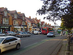
and Summertown
, with its local shopping centre. Parallel and to the west is the Woodstock Road, which it meets at the junction with St Giles'. To the north, Banbury Road meets the Oxford Ring Road
at a roundabout. The road is designated the A4165 (which continues for a short distance as Oxford Road to Kidlington).
 The Mathematical Institute of Oxford University
is at the lower end of the road on the east side. Opposite Keble Road
is St Giles' Church
, built in 1120 and consecrated in 1200. Further north are the Denys Wilkinson Building
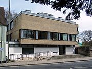
(astrophysics) and the prominent 1960s Thom Building of the Engineering Science department
.
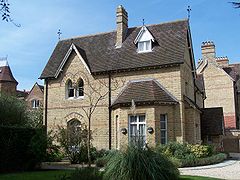
St Anne's College backs onto Banbury Road and St Hugh's College
flanks the road further up. Both are former women's colleges of the University. Kellogg College and Wycliffe Hall, which are also part of the university are situated on Banbury Road, near to the junction with Bevington Road
.
The Independent Sixth Form of d'Overbroeck's College
is in the Swan Building at 111 Banbury Road.
The Banbury Road Medical Centre is an National Health Service
facility at 172 Banbury Road.
BBC Oxford
is also based on the Banbury Road and is home to the local televised news output and BBC Radio Oxford. In early 1970 the BBC Oxford studios were actually located further down at 242-254 Banbury Road (now a Marks & Spencer
supermarket), but were later moved to 269 in 1989 as local media services within BBC Oxford expanded.
who produced the first Oxford English Dictionary
(a blue plaque
now marks the site) and the zoologist Desmond Morris
, author of The Naked Ape
.
Jesse Elliston
, the proprietor of what became Oxford's leading department store, Elliston & Cavell, died in the Banbury Road in 1853 at the age of only 47.
Oxford
The city of Oxford is the county town of Oxfordshire, England. The city, made prominent by its medieval university, has a population of just under 165,000, with 153,900 living within the district boundary. It lies about 50 miles north-west of London. The rivers Cherwell and Thames run through...
, England, running from St Giles' at the south end, north towards Banbury
Banbury
Banbury is a market town and civil parish on the River Cherwell in the Cherwell District of Oxfordshire. It is northwest of London, southeast of Birmingham, south of Coventry and north northwest of the county town of Oxford...
through the leafy suburb of North Oxford
North Oxford
North Oxford is a suburban part of the city of Oxford in England. It was owned for many centuries largely by St John's College, Oxford and many of the area's Victorian houses were initially sold on leasehold by the College....
and Summertown
Summertown, Oxford
Summertown in North Oxford is a suburb of Oxford, England.Summertown is a residential area, one mile square north of St Giles, the beautiful boulevard leading out of Oxford’s city centre. Summertown is home to exclusive schools and the city’s most expensive houses. On both sides of Banbury Road are...
, with its local shopping centre. Parallel and to the west is the Woodstock Road, which it meets at the junction with St Giles'. To the north, Banbury Road meets the Oxford Ring Road
Oxford Ring Road
The Oxford ring road is a ring road around the city of Oxford, England. It is a dual carriageway for most of its length apart from a short section to the North between the Woodstock and Banbury Roads....
at a roundabout. The road is designated the A4165 (which continues for a short distance as Oxford Road to Kidlington).
Buildings
The Mathematical Institute, University of Oxford
The Mathematical Institute is the mathematics department at the University of Oxford, England. It forms one of the ten departments of the Mathematical, Physical and Life Sciences Divisional Board in the University....
is at the lower end of the road on the east side. Opposite Keble Road
Keble Road
Keble Road is a short road running east-west in central Oxford, England. To the west is the southern end of the Banbury Road with St Giles' Church opposite. To the east is Parks Road with the University Parks opposite...
is St Giles' Church
St Giles' Church, Oxford
St. Giles' Church is a church in North Oxford, England. It is at the northern end of the wide thoroughfare of St Giles', at the point where meets Woodstock Road and Banbury Road...
, built in 1120 and consecrated in 1200. Further north are the Denys Wilkinson Building
Denys Wilkinson Building
The Denys Wilkinson Building is a prominent 1960s building at the southern end of the Banbury Road in Oxford, England, designed by Philip Dowson at Arup in 1967....
(astrophysics) and the prominent 1960s Thom Building of the Engineering Science department
Department of Engineering Science, University of Oxford
The Department of Engineering Science is the focus of study of engineering science at Oxford University, England. It is located on the triangular plot formed by Banbury Road to the west, Parks Road to the east and Keble Road to the south. The main building is the tall 1960s Thom Building that...
.
St Anne's College backs onto Banbury Road and St Hugh's College
St Hugh's College, Oxford
St Hugh's College is one of the constituent colleges of the University of Oxford. It is located on a fourteen and a half acre site on St Margaret's Road, to the North of the city centre. It was founded in 1886 as a women's college, and accepted its first male students in its centenary year in 1986...
flanks the road further up. Both are former women's colleges of the University. Kellogg College and Wycliffe Hall, which are also part of the university are situated on Banbury Road, near to the junction with Bevington Road
Bevington Road
Bevington Road is a road in central North Oxford, England.The road runs between Woodstock Road to the west and Banbury Road to the east. Winchester Road leads north from half way along Bevington Road....
.
The Independent Sixth Form of d'Overbroeck's College
D'Overbroeck's College
d’Overbroeck’s College is a co-educational independent school in Oxford for pupils aged 11–18. It is described by The Good Schools Guide as 'a place of energy and laughter, of single-minded determination among students to do the best they can...
is in the Swan Building at 111 Banbury Road.
The Banbury Road Medical Centre is an National Health Service
National Health Service
The National Health Service is the shared name of three of the four publicly funded healthcare systems in the United Kingdom. They provide a comprehensive range of health services, the vast majority of which are free at the point of use to residents of the United Kingdom...
facility at 172 Banbury Road.
BBC Oxford
BBC Oxford
BBC Oxford is the name given to the sub-opt out region serving Oxford and the surrounding areas. Its services include:*BBC Oxford News, the local news service called BBC Oxford on screen...
is also based on the Banbury Road and is home to the local televised news output and BBC Radio Oxford. In early 1970 the BBC Oxford studios were actually located further down at 242-254 Banbury Road (now a Marks & Spencer
Marks & Spencer
Marks and Spencer plc is a British retailer headquartered in the City of Westminster, London, with over 700 stores in the United Kingdom and over 300 stores spread across more than 40 countries. It specialises in the selling of clothing and luxury food products...
supermarket), but were later moved to 269 in 1989 as local media services within BBC Oxford expanded.
People
Famous residents include the lexicographer James MurrayJames Murray (lexicographer)
Sir James Augustus Henry Murray was a Scottish lexicographer and philologist. He was the primary editor of the Oxford English Dictionary from 1879 until his death.-Life and learning:...
who produced the first Oxford English Dictionary
Oxford English Dictionary
The Oxford English Dictionary , published by the Oxford University Press, is the self-styled premier dictionary of the English language. Two fully bound print editions of the OED have been published under its current name, in 1928 and 1989. The first edition was published in twelve volumes , and...
(a blue plaque
Blue plaque
A blue plaque is a permanent sign installed in a public place to commemorate a link between that location and a famous person or event, serving as a historical marker....
now marks the site) and the zoologist Desmond Morris
Desmond Morris
Desmond John Morris, born 24 January 1928 in Purton, north Wiltshire, is a British zoologist and ethologist, as well as a popular anthropologist. He is also known as a painter, television presenter and popular author.-Life:...
, author of The Naked Ape
The Naked Ape
The Naked Ape: A Zoologist's Study of the Human Animal is a 1967 book by zoologist and anthropologist Desmond Morris which looks at humans as a species and compares them to other animals...
.
Jesse Elliston
Jesse Elliston
Jesse Elliston was a proprietor of Elliston & Cavell, that became the leading department store in Oxford, England.Elliston owned a draper's shop in central Oxford when his sister, Sarah Elliston of Summertown in north Oxford, married John Cavell on 9 April 1835. As a result, Elliston made Cavell a...
, the proprietor of what became Oxford's leading department store, Elliston & Cavell, died in the Banbury Road in 1853 at the age of only 47.
Adjoining roads in North Oxford
- Bardwell RoadBardwell RoadBardwell Road is a road in North Oxford, England, off the Banbury Road.The road is the location of the Dragon School, a well-known preparatory school. The second headmaster, Charles Cotterill Lynam , took a building lease on land to the southeast of Bardwell Road in 1893. In 1894, Lynam's Oxford...
- Beech Croft Road
- Belbroughton RoadBelbroughton RoadBelbroughton Road is a residential road in the suburb of North Oxford, England. The road runs east from Banbury Road. At the other end is Oxford High School, a girls' school. South from the road about half way along is Northmoor Road, where J.R.R. Tolkien lived for a while in the 1930s. At the...
- Bevington RoadBevington RoadBevington Road is a road in central North Oxford, England.The road runs between Woodstock Road to the west and Banbury Road to the east. Winchester Road leads north from half way along Bevington Road....
- Canterbury RoadCanterbury RoadCanterbury Road is a road in North Oxford, England. It runs between Woodstock Road to the west and Banbury Road to the east. Winchester Road leads south from half way along Bevington Road....
- Five Mile Drive
- Keble RoadKeble RoadKeble Road is a short road running east-west in central Oxford, England. To the west is the southern end of the Banbury Road with St Giles' Church opposite. To the east is Parks Road with the University Parks opposite...
- Lathbury Road
- Linton RoadLinton RoadLinton Road is a road in North Oxford, England.-Location:At the western end is the Banbury Road. At the eastern end is Wolfson College, a graduate college of the University of Oxford. The road also adjoins Northmoor Road, Charlbury Road and Chadlington Road.Linton Lodge Hotel is located in this...
- Marston Ferry RoadMarston Ferry RoadMarston Ferry Road is a link road in north Oxford, England.The road links the Banbury Road in North Oxford just south of Summertown with Cherwell Drive in Marston, continuing as Headley Way to Headington to the southeast. It is a modern link road with a bridge over the River Cherwell about half way...
- Moreton Road
- Norham GardensNorham GardensNorham Gardens is a residential road in central north Oxford, England. It adjoins the north end of Parks Road near the junction with Banbury Road. From here it skirts the north side of the Oxford University Parks, ending up at Lady Margaret Hall, a college of Oxford University that was formerly for...
- Norham RoadNorham RoadNorham Road lies east off Banbury Road in central North Oxford, a suburb in the city of Oxford, England.- Location :The road is within the Norham Manor area. It consists mainly of large Victorian houses, many of three storeys above ground with a basement below...
- North ParadeNorth ParadeNorth Parade, or more formally North Parade Avenue, is a short shopping street in north Oxford, England. It runs between Winchester Road to the west and Banbury Road to the east...
- Park TownPark Town, OxfordPark Town is a small residential area in central North Oxford, a suburb of Oxford, England. It was one of the earliest planned suburban developments in the area.-History and overview:...
- Parks RoadParks RoadParks Road is a road in Oxford, England, with several Oxford University colleges along its route. It runs north-south from the Banbury Road and Norham Gardens at the northern end, where it continues into Bradmore Road, to the junction with Broad Street, Holywell Street and Catte Street to the...
- Rawlinson Road
- South ParadeSouth ParadeSouth Parade is a shopping street in Summertown, north Oxford, England. It runs between Woodstock Road to the west and Banbury Road to the east, where there are also shops stretching south from South Parade....
- Staverton Road
- St Giles'
- St Margaret's RoadSt Margaret's RoadSt Margaret's Road is a road in North Oxford, England. It runs between Kingston Road to the west and Banbury Road to the east, crossing Woodstock Road. To the south are Farndon Road to the west and Canterbury Road to the east...
- Victoria Road
- Woodstock Road