
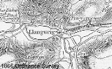
Llangurig
Encyclopedia
Llangurig is a village
in Powys
, within the historic county boundaries of Montgomeryshire
, mid Wales
, lying on the River Wye
. The population is 670.
Llangurig is reputed to be the highest village in Wales at an altitude of 1000 feet. The A470
trunk road
passes through the village as does National Cycle Route 8
.
The 15th century parish church
located in the village is dedicated to Saint Curig, its reputed founder. There are also two small chapels.
The village has been home for many decades to a craft shop as well as two public houses, a number of bed and breakfasts and a small village shop and Post Office
. The manor house
, Clochfaen Hall, was designed by architect, William Arthur Smith Benson a designer of the Arts and Crafts movement
. He also designed the drinking fountain between the road and the village green
, the erection of which commemorates the completion of the village's piped water supply
, a scheme begun by Colonel Lloyd-Verney to whom the fountain is also a memorial.
Llangurig has a small primary school. In January 2003 the school had only 19 pupils but fought a successful campaign against closure by the local council.. The school eventually closed at the end of the 2008 academic year .
The village holds an annual agricultural show
and sheepdog trials in August.
to Aberystwyth
- one for the Manchester and Milford (Haven) Railway Co, the other for the Mid Wales Railway Co. The M&M intended to connect the two settlements with a route across Wales, to enable industry to access the deep-water port. Predicted traffic included American cotton for the mills of Manchester. This resulted in the construction of much of the Carmarthen Aberystwyth Line, which had reached Tregaron
at the time. The Mid Wales had running rights from Newtown to Builth, Brecon, and Cardiff.
 The MWR was authorized to build its line by act of parliament in 1859. The M&M was likewise authorized in 1860.
The line was to head west from Llanidloes by way of Llangurig to Pant Mawr, through a tunnel, turning southwards for Ysbyty Ystwyth
and Tregaron,
finally connecting with the Carmarthen & Cardigan Railway at Pencader
.
The MWR and M&M approaches to Llanidloes covered the same territory. This caused the M&M to prioritize work on this section
and by 1861 contractors' work forces were physically clashing.
The MWR and M&M both offered to make their facilities available to the other, at a price.
Unusually the situation was resolved with the help of a third party. An 1862 act of parliament authorized the Llanidloes and Newtown Railway Co
to extend southwards with 1.5 miles of double track to Penpontbren, where the MWR and M&M would diverge.
The M&M and MWR were to pay 5% per anum on construction costs and maintenance.
Also the three companies were to pay equal shares of interest and running costs for the new station at Llanidloes.
These charges were eventually to prove crippling for the M&M.
The "Llangurig branch line" was fully built, and a single goods train ran along its length, at which point the L&N invoiced the M&M for the cost of the joint station at Llanidloes. The branch service was immediately terminated, being wholly unprofitable without through traffic. The M&M continued to pay for the cost of the joint station they could not reach.
By 1864 the M&M had changed its plans for crossing the Pumlumon range. They now wanted to abandon the route through Pant Mawr,
and instead intended to follow the Nant Troedyregair from Llanrug. This caused any work west of Llanrug to be abandoned.
The change was, in the event, not authorized by parliament. However, the MWR then proposed its own westward extension,
which was authorized, by an act of 1865. This was to branch west from a junction at Aber Marteg (where its route crosses the A470)
up the Wye and Nant-y-Dernol valleys. The MWR was supposed to build another line from here directly to Llanrug, to join up with the M&M route.
A 1.5-mile-long tunnel would burrow under the mountains to a descent to Ysbyty Ystwyth. From there the M&M were to provide lines to the south
through Ystrad Meurig
(Strata Florida station) and west to Aberystwyth
.
1866 was a difficult year, including the collapse of the London Bank Overend, Gurney and Company
, causing many industrial projects to encounter financial hardship.
By 1876 MWR had still failed to build the new route, with an act of parliament permitting abandonment of the scheme.
In 1882 the M&M started to dismantle the Llangurig branch, lifting 1.5 miles of the essentially unused track for maintenance purposes elsewhere.
The M&M became a cross country route from Carmarthen to Aberystwyth, being absorbed into the Great Western Railway
. Penbontbren Junction signal box existed and was manned until the Mid Wales line closed. A large part of the route east of Llangurig is marked on current OS maps as 'dismantled railway', much of the course close to the A470 road through Nant gwynwydd being clearly visible. Some earthworks and tunnel headings survive from the original M&M scheme west of Llangurig.
A view of Llangurig station can be seen .
Village
A village is a clustered human settlement or community, larger than a hamlet with the population ranging from a few hundred to a few thousand , Though often located in rural areas, the term urban village is also applied to certain urban neighbourhoods, such as the West Village in Manhattan, New...
in Powys
Powys
Powys is a local-government county and preserved county in Wales.-Geography:Powys covers the historic counties of Montgomeryshire and Radnorshire, most of Brecknockshire , and a small part of Denbighshire — an area of 5,179 km², making it the largest county in Wales by land area.It is...
, within the historic county boundaries of Montgomeryshire
Montgomeryshire
Montgomeryshire, also known as Maldwyn is one of thirteen historic counties and a former administrative county of Wales. Montgomeryshire is still used as a vice-county for wildlife recording...
, mid Wales
Mid Wales
Mid Wales is the name given to the central region of Wales. The Mid Wales Regional Committee of the National Assembly for Wales covered the counties of Ceredigion and Powys and the area of Gwynedd that had previously been the district of Meirionydd. A similar definition is used by the BBC...
, lying on the River Wye
River Wye
The River Wye is the fifth-longest river in the UK and for parts of its length forms part of the border between England and Wales. It is important for nature conservation and recreation.-Description:...
. The population is 670.
Llangurig is reputed to be the highest village in Wales at an altitude of 1000 feet. The A470
A470 road
The A470 is a major long-distance connective spine road in Wales, running from Cardiff on the south coast to Llandudno on the north coast. It covers approximately 186 miles , over a zig-zagging route through the entirety of the country's mountainous central region, including the Brecon Beacons and...
trunk road
Trunk road
A trunk road, trunk highway, or strategic road is a major road—usually connecting two or more cities, ports, airports, and other things.—which is the recommended route for long-distance and freight traffic...
passes through the village as does National Cycle Route 8
National Cycle Route 8
The route passes through the heart of Wales, and is also known by its Welsh name Lôn Las Cymru . It is largely north-south from Holyhead to Cardiff and Chepstow, and in total measures some in length...
.
The 15th century parish church
Parish church
A parish church , in Christianity, is the church which acts as the religious centre of a parish, the basic administrative unit of episcopal churches....
located in the village is dedicated to Saint Curig, its reputed founder. There are also two small chapels.
The village has been home for many decades to a craft shop as well as two public houses, a number of bed and breakfasts and a small village shop and Post Office
Post office
A post office is a facility forming part of a postal system for the posting, receipt, sorting, handling, transmission or delivery of mail.Post offices offer mail-related services such as post office boxes, postage and packaging supplies...
. The manor house
Manor house
A manor house is a country house that historically formed the administrative centre of a manor, the lowest unit of territorial organisation in the feudal system in Europe. The term is applied to country houses that belonged to the gentry and other grand stately homes...
, Clochfaen Hall, was designed by architect, William Arthur Smith Benson a designer of the Arts and Crafts movement
Arts and Crafts movement
Arts and Crafts was an international design philosophy that originated in England and flourished between 1860 and 1910 , continuing its influence until the 1930s...
. He also designed the drinking fountain between the road and the village green
Village green
A village green is a common open area which is a part of a settlement. Traditionally, such an area was often common grass land at the centre of a small agricultural settlement, used for grazing and sometimes for community events...
, the erection of which commemorates the completion of the village's piped water supply
Water supply
Water supply is the provision of water by public utilities, commercial organisations, community endeavours or by individuals, usually via a system of pumps and pipes...
, a scheme begun by Colonel Lloyd-Verney to whom the fountain is also a memorial.
Llangurig has a small primary school. In January 2003 the school had only 19 pupils but fought a successful campaign against closure by the local council.. The school eventually closed at the end of the 2008 academic year .
The village holds an annual agricultural show
Agricultural show
An agricultural show is a public event showcasing the equipment, animals, sports and recreation associated with agriculture and animal husbandry. The largest comprise a livestock show , a trade fair, competitions, and entertainment...
and sheepdog trials in August.
'The Railway that never was'
During the Victorian period, Llangurig nearly had a railway service. Wales' rail network was built piecemeal by many small companies, and parliament mistakenly granted acts for two lines through the same piece of terrain, linking LlanidloesLlanidloes
Llanidloes is a town along the A470 road and B4518 road in Powys, within the historic county boundaries of Montgomeryshire , Mid Wales.It is the first town on the River Severn...
to Aberystwyth
Aberystwyth
Aberystwyth is a historic market town, administrative centre and holiday resort within Ceredigion, Wales. Often colloquially known as Aber, it is located at the confluence of the rivers Ystwyth and Rheidol....
- one for the Manchester and Milford (Haven) Railway Co, the other for the Mid Wales Railway Co. The M&M intended to connect the two settlements with a route across Wales, to enable industry to access the deep-water port. Predicted traffic included American cotton for the mills of Manchester. This resulted in the construction of much of the Carmarthen Aberystwyth Line, which had reached Tregaron
Tregaron
Tregaron is a market town in the county of Ceredigion, Wales, lying on the River Brenig , a tributary of the River Teifi. The town is twinned with Plouvien, in Finistere, France. According to the 2001 Census, Tregaron's population was 1,183, of whom 68.8% spoke Welsh fluently.-History:Tregaron...
at the time. The Mid Wales had running rights from Newtown to Builth, Brecon, and Cardiff.
The line was to head west from Llanidloes by way of Llangurig to Pant Mawr, through a tunnel, turning southwards for Ysbyty Ystwyth
Ysbyty Ystwyth
Ysbyty Ystwyth is a small village in Ceredigion, Wales 13 miles S.E.S. from Aberystwyth. Its church and the parish of the same name were the property of the Order of the Knights of the Hospital of St John of Jerusalem, hence the 'Ysbyty' in the title , which never was a hospice for travellers...
and Tregaron,
finally connecting with the Carmarthen & Cardigan Railway at Pencader
Pencader, Carmarthenshire
Pencader is a small village in the Welsh county of Carmarthenshire, and is part of the Community and Parish of Llanfihangel-ar-Arth. It is located around 5 km south-east of Llandysul and 10 km south-west of Llanybydder....
.
The MWR and M&M approaches to Llanidloes covered the same territory. This caused the M&M to prioritize work on this section
and by 1861 contractors' work forces were physically clashing.
The MWR and M&M both offered to make their facilities available to the other, at a price.
Unusually the situation was resolved with the help of a third party. An 1862 act of parliament authorized the Llanidloes and Newtown Railway Co
to extend southwards with 1.5 miles of double track to Penpontbren, where the MWR and M&M would diverge.
The M&M and MWR were to pay 5% per anum on construction costs and maintenance.
Also the three companies were to pay equal shares of interest and running costs for the new station at Llanidloes.
These charges were eventually to prove crippling for the M&M.
The "Llangurig branch line" was fully built, and a single goods train ran along its length, at which point the L&N invoiced the M&M for the cost of the joint station at Llanidloes. The branch service was immediately terminated, being wholly unprofitable without through traffic. The M&M continued to pay for the cost of the joint station they could not reach.
By 1864 the M&M had changed its plans for crossing the Pumlumon range. They now wanted to abandon the route through Pant Mawr,
and instead intended to follow the Nant Troedyregair from Llanrug. This caused any work west of Llanrug to be abandoned.
The change was, in the event, not authorized by parliament. However, the MWR then proposed its own westward extension,
which was authorized, by an act of 1865. This was to branch west from a junction at Aber Marteg (where its route crosses the A470)
up the Wye and Nant-y-Dernol valleys. The MWR was supposed to build another line from here directly to Llanrug, to join up with the M&M route.
A 1.5-mile-long tunnel would burrow under the mountains to a descent to Ysbyty Ystwyth. From there the M&M were to provide lines to the south
through Ystrad Meurig
Ystrad Meurig
Ystrad Meurig is a village in Ceredigion, Wales. It lies on the B4340 road northwest of the town of Tregaron.- History & Amenities :...
(Strata Florida station) and west to Aberystwyth
Aberystwyth
Aberystwyth is a historic market town, administrative centre and holiday resort within Ceredigion, Wales. Often colloquially known as Aber, it is located at the confluence of the rivers Ystwyth and Rheidol....
.
1866 was a difficult year, including the collapse of the London Bank Overend, Gurney and Company
Overend, Gurney and Company
Overend, Gurney & Company was a London wholesale discount bank, known as "the bankers' bank", which collapsed in 1866 owing about 11 million pounds, equivalent to £981 million at 2008 prices.-Early years:...
, causing many industrial projects to encounter financial hardship.
By 1876 MWR had still failed to build the new route, with an act of parliament permitting abandonment of the scheme.
In 1882 the M&M started to dismantle the Llangurig branch, lifting 1.5 miles of the essentially unused track for maintenance purposes elsewhere.
The M&M became a cross country route from Carmarthen to Aberystwyth, being absorbed into the Great Western Railway
Great Western Railway
The Great Western Railway was a British railway company that linked London with the south-west and west of England and most of Wales. It was founded in 1833, received its enabling Act of Parliament in 1835 and ran its first trains in 1838...
. Penbontbren Junction signal box existed and was manned until the Mid Wales line closed. A large part of the route east of Llangurig is marked on current OS maps as 'dismantled railway', much of the course close to the A470 road through Nant gwynwydd being clearly visible. Some earthworks and tunnel headings survive from the original M&M scheme west of Llangurig.
A view of Llangurig station can be seen .
- The Llangurig branch is noted in trivia as being the shortest lived working branch line in the UK - receiving precisely 1 train.