

Barotse Floodplain
Encyclopedia
Floodplain
A floodplain, or flood plain, is a flat or nearly flat land adjacent a stream or river that stretches from the banks of its channel to the base of the enclosing valley walls and experiences flooding during periods of high discharge...
also known as the Bulozi Plain, Lyondo or the Zambezi Floodplain is one of Africa's great wetland
Zambezian flooded grasslands
The Zambezian flooded grasslands is an ecoregion of southern and eastern Africa that is rich in wildlife.-Setting:The Zambezian flooded grasslands can be found on seasonally or permanently flooded lowlands in the basin of the Zambezi and neighboring river basins...
s, on the Zambezi River in the Western Province
Western Province, Zambia
Western Province, encompasses the area formerly known as Barotseland in the colonial era.-Districts:Western Province is divided into 7 districts:*Kalabo District*Kaoma District*Lukulu District*Mongu District*Senanga District*Sesheke District...
of Zambia
Zambia
Zambia , officially the Republic of Zambia, is a landlocked country in Southern Africa. The neighbouring countries are the Democratic Republic of the Congo to the north, Tanzania to the north-east, Malawi to the east, Mozambique, Zimbabwe, Botswana and Namibia to the south, and Angola to the west....
. It is a designated Ramsar site
Ramsar Convention
The Ramsar Convention is an international treaty for the conservation and sustainable utilization of wetlands, i.e., to stem the progressive encroachment on and loss of wetlands now and in the future, recognizing the fundamental ecological functions of wetlands and their economic, cultural,...
, regarded as being of high conservation value.
The name recognises the floodplain
Floodplain
A floodplain, or flood plain, is a flat or nearly flat land adjacent a stream or river that stretches from the banks of its channel to the base of the enclosing valley walls and experiences flooding during periods of high discharge...
as spawning the culture and way of life of the Lozi people
Lozi people
The Lozi people are an ethnic group primarily of western Zambia, inhabiting the region of Barotseland. Lozi are also found in Namibia , Angola and Botswana.-Name:...
, "Rotse" being a variant of Lozi, and "Ba" meaning "people". They became a powerful kingdom in Central
Central Africa
Central Africa is a core region of the African continent which includes Burundi, the Central African Republic, Chad, the Democratic Republic of the Congo, and Rwanda....
/Southern Africa
Southern Africa
Southern Africa is the southernmost region of the African continent, variably defined by geography or geopolitics. Within the region are numerous territories, including the Republic of South Africa ; nowadays, the simpler term South Africa is generally reserved for the country in English.-UN...
under their King or Litunga
Litunga
The Litunga of Barotseland is the king or paramount chief of the Lozi people. The Litunga resides near the Zambezi River and the town of Mongu, at Lealui on the floodplain in the dry season, and on higher ground at Limulunga on the edge of the floodplain in the wet season...
, Lewanika
Lewanika
Lewanika was the Lozi Litunga of Barotseland from 1878 to 1916...
, whose realm extended up to 300 km from the plain and was called Barotseland
Barotseland
Barotseland is a region in the western part of Zambia, and is the homeland of the Lozi people or Barotse who were previously known as Luyi or Aluyi. Its heartland is the Barotse Floodplain on the upper Zambezi River, also known as Bulozi or Lyondo, but it includes the surrounding higher ground of...
.
Topography and area
The region is a flat plateauPlateau
In geology and earth science, a plateau , also called a high plain or tableland, is an area of highland, usually consisting of relatively flat terrain. A highly eroded plateau is called a dissected plateau...
at an elevation of about 1000 m tilting very slightly to the south. The Zambezi and its headwaters rise on the higher ground to the north, which enjoys good rainfall (1400 mm annually) in a rainy season from October to May. A flood moves down the river reaching a flat region, formed from Kalahari sands, about five hundred kilometres across. To the south around the Ngonye Falls
Ngonye Falls
The Ngonye Falls or Sioma Falls are a waterfall on the Zambezi river in Western Zambia, near the town of Sioma and a few hundred kilometers upstream from the Victoria Falls. Situated in the southern part of Barotseland, the falls are a difficult two or three day journey from the capital, Lusaka...
harder rock is found at the surface and has resisted the river's tendency to cut a channel down into it, and so acts a bit like a dam. Behind it the floodplain has formed. Below the falls the river falls nearly twice as fast as it does on the plain, and flows more swiftly in a narrower valley less prone to flooding.
The floodplain stretches from the Zambezi's confluence
Confluence
Confluence, in geography, describes the meeting of two or more bodies of water.Confluence may also refer to:* Confluence , a property of term rewriting systems...
with the Kabompo
Kabompo River
The Kabompo River is one of the main tributaries of the upper Zambezi River river. It flows entirely in Zambia, rising to the east of the source of the Zambezi, in North-Western Province along the watershed between the Zambezi and Congo river basins which also forms the border between Zambia and DR...
and Lungwebungu River
Lungwebungu River
The Lungwebungu River of south-west-central Africa is the largest tributary of the upper Zambezi River. The headwaters of the Lungwebungu are in central Angola at an elevation around 1400 m, and it flows south-east across the southern African plateau...
s in the north, to a point about 230 km south, above the Ngonye falls and south of Senanga
Senanga
Senanga is a town in the Western Province of Zambia, on the eastern bank of the Zambezi River, at the southern end of its Barotse Floodplain. It lies on the main road running parallel to the river from Livingstone and Sesheke to Mongu, which crosses the river by a pontoon ferry about 15 km ...
. Along most of its length its width is over 30 km, reaching 50 km at the widest, just north of Mongu
Mongu
Mongu is the capital of Western Province in Zambia and was the capital of the formerly-named province and historic state, Barotseland. Its population is 44,310 , and it is also headquarters of Mongu District.-Geography:...
, principal town of the plain, situated at its edge. The main body of the plain covers about 5500 km²,
but the maximum flooded area is 10 750 km² when the floodplains of several tributaries are taken into account, such as the Luena Flats
Luena River, Western Zambia
The Luena River of Zambia's Western Province rises just west of the Kafue National Park and flows west through Kaoma to become a tributary of the Zambezi. In the dry season, just below its confluence with its seasonal tributary the Luampa River, it ends in swamps or marshes on the Luena Flats east...
. The Barotse Floodplain is the second largest wetland in Zambia after the Lake Bangweulu
Lake Bangweulu
Bangweulu — 'where the water sky meets the sky' — is one of the world's great wetland systems, comprising Lake Bangweulu, the Bangweulu Swamps and the Bangweulu Flats or floodplain...
system, which differs in having a large permanent lake and swamps, and a much smaller area which dries out annually.
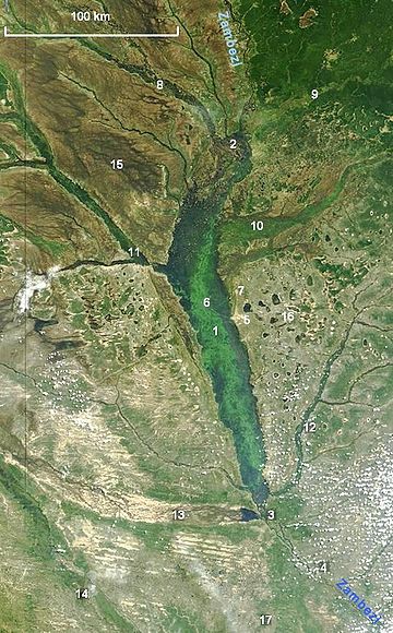
The satellite photo was taken in April 2004 at the peak of the flood, Note that the northern part of the plain, near Lukulu, is less flooded, the land there varies a bit more in height and the water tends to keep to the many river channels.
Flood levels and timing
- See also Climate of ZambiaClimate of ZambiaThe climate of Zambia in Central and Southern Africa is tropical modified by altitude . In the Köppen climate classification, most of the country is classified as humid subtropical or tropical wet and dry, with small patches of semi-arid steppe climate in the south-west.Climate and specifically...
The peak of the flood
Flood
A flood is an overflow of an expanse of water that submerges land. The EU Floods directive defines a flood as a temporary covering by water of land not normally covered by water...
occurs on the floodplain about 3 months after the peak of the rainy season in January-February. The flood usually peaks in April, and recedes in May to July, when grasses quickly grow on the exposed plain. At the river's lowest water in November the floodplain still contains about 537 km² of lagoon
Lagoon
A lagoon is a body of shallow sea water or brackish water separated from the sea by some form of barrier. The EU's habitat directive defines lagoons as "expanses of shallow coastal salt water, of varying salinity or water volume, wholly or partially separated from the sea by sand banks or shingle,...
s, swamp
Swamp
A swamp is a wetland with some flooding of large areas of land by shallow bodies of water. A swamp generally has a large number of hammocks, or dry-land protrusions, covered by aquatic vegetation, or vegetation that tolerates periodical inundation. The two main types of swamp are "true" or swamp...
s and channels. The flood leaves behind a fertile grey to black soil overlaying the Kalahari sands, enriched by silt
Silt
Silt is granular material of a size somewhere between sand and clay whose mineral origin is quartz and feldspar. Silt may occur as a soil or as suspended sediment in a surface water body...
deposited by the flood as well as humus from vegetation killed by the initial flood, and from decaying aquatic plants left to dry out in the mud. It provides a good soil, but in the late dry season it bakes hard in the heat of the sun.
As the floods recede, water is left behind in lagoons, swamps, and oxbow lake
Oxbow lake
An oxbow lake is a U-shaped body of water formed when a wide meander from the main stem of a river is cut off to create a lake. This landform is called an oxbow lake for the distinctive curved shape, named after part of a yoke for oxen. In Australia, an oxbow lake is called a billabong, derived...
s.
Natural environment
The floodplain is in the Zambezian flooded grasslands ecoregionEcoregion
An ecoregion , sometimes called a bioregion, is an ecologically and geographically defined area that is smaller than an ecozone and larger than an ecosystem. Ecoregions cover relatively large areas of land or water, and contain characteristic, geographically distinct assemblages of natural...
, and is bordered by slightly higher sandy ground on which grow dry grasslands (Western Zambezian grasslands) with woodland savanna (Zambezian Baikiaea woodlands) to the east and south, and patches of evergreen forest (Cryptosepalum dry forests) in the north and east.
The flood provides aquatic habitats for fish such as tigerfish
Tigerfish
Tigerfish is the common name for a variety of species from several different families of fish, usually on account of their colouration or otherwise fearsome appearance and teeth.- Alestiidae :...
and bream, crocodiles
Nile crocodile
The Nile crocodile or Common crocodile is an African crocodile which is common in Somalia, Ethiopia, Uganda, Kenya, Egypt, Tanzania, Zambia, Zimbabwe, Gabon, South Africa, Malawi, Sudan, Botswana, and Cameroon...
, hippopotamus
Hippopotamus
The hippopotamus , or hippo, from the ancient Greek for "river horse" , is a large, mostly herbivorous mammal in sub-Saharan Africa, and one of only two extant species in the family Hippopotamidae After the elephant and rhinoceros, the hippopotamus is the third largest land mammal and the heaviest...
, waterbirds, fish-eating birds, and lechwe
Lechwe
The Lechwe, or Southern Lechwe, is an antelope found in Botswana, Zambia, south-eastern Democratic Republic of the Congo, north-eastern Namibia, and eastern Angola, especially in the Okavango Delta, Kafue Flats and Bangweulu Swamps....
, the wading antelope
Antelope
Antelope is a term referring to many even-toed ungulate species indigenous to various regions in Africa and Eurasia. Antelopes comprise a miscellaneous group within the family Bovidae, encompassing those old-world species that are neither cattle, sheep, buffalo, bison, nor goats...
. After the flood, the plain is a habitat for grazing animals such as wildebeest
Wildebeest
The wildebeest , also called the gnu is an antelope of the genus Connochaetes. It is a hooved mammal...
, zebra
Zebra
Zebras are several species of African equids united by their distinctive black and white stripes. Their stripes come in different patterns unique to each individual. They are generally social animals that live in small harems to large herds...
, tsessebe and small antelope such oribi
Oribi
Oribi are graceful slender-legged, long-necked small antelope found in grassland almost throughout Sub-Saharan Africa.-Description:...
and steenbok
Steenbok
The Steenbok, Raphicerus campestris, is a common small antelope of southern and eastern Africa. It is sometimes known as the Steinbuck or Steinbok.- Description :...
, and their predators.
These herbivores have been displaced in most areas by the cattle grazed by the Lozi, but they have provided a large game reserve on the dry grassland to the west, the Liuwa Plain National Park
Liuwa Plain National Park
The Liuwa Plain National Park lies in Western Province, Zambia, west of the Barotse Floodplain of the Zambezi River near the border with Angola.-History:...
, once the Litunga's hunting grounds, established as a game reserve by Lewanika in the 19th century. In addition the entire western of the Zambezi within the country is a Game Management Area.
Human ecology of the plain
About 250,000 people live on the plain with a similar number of cattle, migratingTranshumance
Transhumance is the seasonal movement of people with their livestock between fixed summer and winter pastures. In montane regions it implies movement between higher pastures in summer and to lower valleys in winter. Herders have a permanent home, typically in valleys. Only the herds travel, with...
to grasslands at the edge of the floodplain when the flood arrives. The floodplain is one of the most productive areas for raising cattle in the country.
The Lozi also catch fish, eating about five times as much as the national average. At the height of the flood they use fish traps and spears for fishing, and they use gill nets in the lagoons left behind by the falling flood. Fish spawn
Spawn (biology)
Spawn refers to the eggs and sperm released or deposited, usually into water, by aquatic animals. As a verb, spawn refers to the process of releasing the eggs and sperm, also called spawning...
just before the flood, the first floodwaters are naturally hypoxic
Hypoxia (environmental)
Hypoxia, or oxygen depletion, is a phenomenon that occurs in aquatic environments as dissolved oxygen becomes reduced in concentration to a point where it becomes detrimental to aquatic organisms living in the system...
(low in oxygen) which kills most fish, while eggs survive.
The Lozi cultivate crops on the floodplain such as maize
Maize
Maize known in many English-speaking countries as corn or mielie/mealie, is a grain domesticated by indigenous peoples in Mesoamerica in prehistoric times. The leafy stalk produces ears which contain seeds called kernels. Though technically a grain, maize kernels are used in cooking as a vegetable...
, rice
Rice
Rice is the seed of the monocot plants Oryza sativa or Oryza glaberrima . As a cereal grain, it is the most important staple food for a large part of the world's human population, especially in East Asia, Southeast Asia, South Asia, the Middle East, and the West Indies...
, sweet potato
Sweet potato
The sweet potato is a dicotyledonous plant that belongs to the family Convolvulaceae. Its large, starchy, sweet-tasting, tuberous roots are an important root vegetable. The young leaves and shoots are sometimes eaten as greens. Of the approximately 50 genera and more than 1,000 species of...
, and sugar cane.
November to January are lean months.
Stored produce from the previous growing season is almost used up and in any case would need to be transported during the migration, while the new season's crops and grasses are not yet productive, and at the same time fishing stops for the spawning season. Hunting and trapping animals, which might have filled the gap, is no longer available to most people, and trapping waterbirds is one of the few alternatives to buying flour.
The floodplain determines and dominates the way of life, economy, society and culture of the Lozi, who are skilled boat-builders, paddlers and swimmers.
The annual migration with the flood is celebrated in the Kuomboka
Kuomboka
Kuomboka is a word in the Lozi language; it literally means ‘to get out of water’. In today's Zambia it is applied to a traditional ceremony that takes place at the end of the rain season, when the upper Zambezi River floods the plains of the Western Province....
ceremony held at Mongu, capital of Barotseland and its successor, the Western Province.
In the occasional very wet year such as 2005, lives and property are lost in floods on the Barotse Plain. More often, however, it is a very good example of the principle that natural annual flooding by rivers is valuable and productive for wildlife and human populations, while damming rivers to control floods, as has happened with the Kafue Flats, is potentially damaging to the environment.
Development on or affecting the plain
Development on the plain has been restricted until now to—- the canalCanalCanals are man-made channels for water. There are two types of canal:#Waterways: navigable transportation canals used for carrying ships and boats shipping goods and conveying people, further subdivided into two kinds:...
dug in colonial timesNorthern RhodesiaNorthern Rhodesia was a territory in south central Africa, formed in 1911. It became independent in 1964 as Zambia.It was initially administered under charter by the British South Africa Company and formed by it in 1911 by amalgamating North-Western Rhodesia and North-Eastern Rhodesia...
to connect a small harbour at Mongu to the Zambezi's channel in the dry season - small villages and compoundsCompound (enclosure)Compound when applied to a human habitat refers to a cluster of buildings in an enclosure, having a shared or associated purpose, such as the houses of an extended family...
constructed on mounds, such as Lealui - a few dry season tracks
- pontoon ferries at Sandaula, Libonda and Lukulu
- some intensive rice and sugarcane plantations.
Tight control over access to the floodplain by the Litunga and the homogeneity of the indigenous people have slowed commercial development by outsiders.
Barotse Floodplain causeway
A new project, the Mongu-Kalabo road, will have more far-reaching consequences. Around 2002 construction started of a 46-kilometre causeway
Causeway
In modern usage, a causeway is a road or railway elevated, usually across a broad body of water or wetland.- Etymology :When first used, the word appeared in a form such as “causey way” making clear its derivation from the earlier form “causey”. This word seems to have come from the same source by...
across the centre of the floodplain to take a paved highway from Mongu to Kalabo, via the ferry across the main river channel at Sandaula, which would then be replaced by a 500-metre bridge. Originally intended to be completed in 2006, it has been delayed by the difficulty of building on the floodplain. There is no rock in the region, and the causeway has been built from sand and gravel scooped out from shallow depressions next to it. Higher than usual floods washed away large sections. The contractor was a Kuwait
Kuwait
The State of Kuwait is a sovereign Arab state situated in the north-east of the Arabian Peninsula in Western Asia. It is bordered by Saudi Arabia to the south at Khafji, and Iraq to the north at Basra. It lies on the north-western shore of the Persian Gulf. The name Kuwait is derived from the...
-based company which acknowledged that conditions were difficult. The Times of Zambia
Times of Zambia
The Times of Zambia is a national daily newspaper published in Zambia.During the colonial period this newspaper was known as The Northern News. It was founded in 1944 as a twice-weekly newspaper aimed at a European readership, owned first by Roy Welensky and then by the South African newspaper...
reported that the company underestimated the floodplain environment, and abandoned the contract. Subsequent modifications have been made to raise the road height and to increase the number and size of culvert
Culvert
A culvert is a device used to channel water. It may be used to allow water to pass underneath a road, railway, or embankment. Culverts can be made of many different materials; steel, polyvinyl chloride and concrete are the most common...
s, and this in turn led to funding problems. In November 2007 it consisted of earth causeways from Mongu to some distance beyond Lealui, and from the ferry at Sandaula to Kalabo. No information is available on the impact the structure will have on flood flow patterns, river channels, silt
Silt
Silt is granular material of a size somewhere between sand and clay whose mineral origin is quartz and feldspar. Silt may occur as a soil or as suspended sediment in a surface water body...
deposition, or on fish and wildlife movements.