

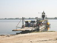
Kazungula Ferry
Encyclopedia
Pontoon (boat)
A pontoon is a flotation device with buoyancy sufficient to float itself as well as a heavy load. A pontoon boat is a flattish boat that relies on pontoons to float. Pontoons may be used on boats, rafts, barges, docks, floatplanes or seaplanes. Pontoons may support a platform, creating a raft. A...
ferry across the 400-metre-wide Zambezi River between Botswana
Botswana
Botswana, officially the Republic of Botswana , is a landlocked country located in Southern Africa. The citizens are referred to as "Batswana" . Formerly the British protectorate of Bechuanaland, Botswana adopted its new name after becoming independent within the Commonwealth on 30 September 1966...
and Zambia
Zambia
Zambia , officially the Republic of Zambia, is a landlocked country in Southern Africa. The neighbouring countries are the Democratic Republic of the Congo to the north, Tanzania to the north-east, Malawi to the east, Mozambique, Zimbabwe, Botswana and Namibia to the south, and Angola to the west....
. It is one of the largest ferries in south-central Africa, having a capacity of 70 tonnes. The service is provided by two motorised pontoons and operates between border posts at Kazungula, Zambia
Kazungula
Kazungula is a small border town in the Southern Province of Zambia, lying on the north bank of the Zambezi River about 70 km west of Livingstone, at an almost quadripoint where four countries nearly meet...
and Kazungula, Botswana
Kazungula, Botswana
Kazungula is a village in the far north of Botswana, 8 km east of the town of Kasane. It lies on the south bank of the Chobe and Zambezi rivers....
.
It links the Livingstone
Livingstone, Zambia
Livingstone or Maramba is a historic colonial city and present capital of the Southern Province of Zambia, a tourism centre for the Victoria Falls lying north of the Zambezi River, and a border town with road and rail connections to Zimbabwe on the other side of the Falls...
-Sesheke
Sesheke
Sesheke is a border town in the Western Province of Zambia, and a district of the same name. It lies on the northern bank of the Zambezi River which forms the border with Namibia's Caprivi Strip at that point....
road (which connects to the Trans–Caprivi Highway at Katima Mulilo
Katima Mulilo
Katima Mulilo is the capital of the Caprivi Strip, Namibia's far north–east extension into central Southern Africa. It comprises two electoral constituencies, Katima Mulilo Rural and Katima Mulilo Urban...
and forms part of the Walvis Bay Corridor
Walvis Bay
Walvis Bay , is a city in Namibia and the name of the bay on which it lies...
) to the main north-south highway of Botswana through Francistown
Francistown
Francistown or Nyangabgwe is the second largest city in Botswana, with a population of about 85,363, and often described as the "Capital of the North". It is located in eastern Botswana, about north-northeast from the capital, Gaborone...
and Gaborone
Gaborone
' is the capital and largest city of Botswana with a population of 191,776 based on a 2006 survey, about 10% of the total population of Botswana....
to South Africa
South Africa
The Republic of South Africa is a country in southern Africa. Located at the southern tip of Africa, it is divided into nine provinces, with of coastline on the Atlantic and Indian oceans...
, and also to the Kasane
Kasane
Kasane is a town in Botswana, close to Africa's 'Four Corners', where four countries almost meet: Botswana, Namibia, Zambia and Zimbabwe. It is at the far north-eastern corner of Botswana where it serves as the administrative center of the Chobe District...
-Victoria Falls
Victoria Falls
The Victoria Falls or Mosi-oa-Tunya is a waterfall located in southern Africa on the Zambezi River between the countries of Zambia and Zimbabwe.-Introduction:...
road through Zimbabwe
Zimbabwe
Zimbabwe is a landlocked country located in the southern part of the African continent, between the Zambezi and Limpopo rivers. It is bordered by South Africa to the south, Botswana to the southwest, Zambia and a tip of Namibia to the northwest and Mozambique to the east. Zimbabwe has three...
. It serves the international road traffic of three countries directly (Zambia, Zimbabwe and Botswana) and of three more indirectly (Namibia, South Africa and DR Congo).
In 2003 the ferry was the site of a disaster
Disaster
A disaster is a natural or man-made hazard that has come to fruition, resulting in an event of substantial extent causing significant physical damage or destruction, loss of life, or drastic change to the environment...
when a severely-overloaded Zambian truck capsized one of the pontoons and 18 people drowned. The accident was blamed on the lack of weighbridges in Zambia to check the weight of trucks.
In August 2007 the governments of Zambia and Botswana announced a deal to construct a bridge at the site to replace the ferry.
At Kazungula the territory of four countries (Zambia, Zimbabwe, Botswana, Namibia) come with a few meters or tens of meters of meeting at a common point. The ever-shifting river channels and the lack of any treaties addressing tripoints or a potential quadripoint
Quadripoint
A quadripoint is a point on the Earth that touches the border of four distinct territories. The term has never been in common use—it may not have been used before 1964, by the Geographer of the United States...
result in no possibility of a quadripoint
Quadripoint
A quadripoint is a point on the Earth that touches the border of four distinct territories. The term has never been in common use—it may not have been used before 1964, by the Geographer of the United States...
legally existing at present.
The countries most interested in having a bridge, Botswana and Zambia, are in the two opposite quadrants that appear most likely to share a short boundary of a few meters or tens of meters, which could possibly obliviate the need to use the territory of either of the other neighbors. The physical layout of the river and a tributary in the area lead to a possible conclusion that the bridge would be somewhat downstream from the near-quadripoint and thus perhaps impinge slightly on Zimbabwe territory. Zimbabwe already has a bridge with Zambia at Victoria Falls, 70km from Kazungula. Namibia already has a crossing with Zambia at Katima Mlilo about 150km upriver. For those travelling from South Africa to Zambia's copperbelt or Lusaka by road, routes through Zimbabwe are several hundred kilometres shorter.