

Kalabo
Encyclopedia
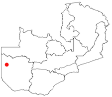
Western Province, Zambia
Western Province, encompasses the area formerly known as Barotseland in the colonial era.-Districts:Western Province is divided into 7 districts:*Kalabo District*Kaoma District*Lukulu District*Mongu District*Senanga District*Sesheke District...
of Zambia
Zambia
Zambia , officially the Republic of Zambia, is a landlocked country in Southern Africa. The neighbouring countries are the Democratic Republic of the Congo to the north, Tanzania to the north-east, Malawi to the east, Mozambique, Zimbabwe, Botswana and Namibia to the south, and Angola to the west....
, on the plains west of the Zambezi River and the Barotse Floodplain
Barotse Floodplain
The Barotse Floodplain also known as the Bulozi Plain, Lyondo or the Zambezi Floodplain is one of Africa's great wetlands, on the Zambezi River in the Western Province of Zambia...
, about 70 km from the border with Angola.
Location
It is situated on the south-eastern bank of the Luanginga RiverLuanginga River
The Luanginga is a river rising in Angola, which flows into the Zambezi in western Zambia....
across which a small pontoon ferry connects to a dirt track going north-west to the Angolan border. Kalabo is the base for the Liuwa Plain National Park
Liuwa Plain National Park
The Liuwa Plain National Park lies in Western Province, Zambia, west of the Barotse Floodplain of the Zambezi River near the border with Angola.-History:...
which can be reached by off-road vehicles about 20 km north of the pontoon. Western Province was formerly known as Barotseland
Barotseland
Barotseland is a region in the western part of Zambia, and is the homeland of the Lozi people or Barotse who were previously known as Luyi or Aluyi. Its heartland is the Barotse Floodplain on the upper Zambezi River, also known as Bulozi or Lyondo, but it includes the surrounding higher ground of...
, and Liuwa Plain was the Barotse king's hunting grounds which Lewanika
Lewanika
Lewanika was the Lozi Litunga of Barotseland from 1878 to 1916...
made into a game reserve in the 19th century.
Transport
Access to Kalabo by road is difficult and it is usually cut off by road in the rainy season. The dirt tracks across the floodplain from MonguMongu
Mongu is the capital of Western Province in Zambia and was the capital of the formerly-named province and historic state, Barotseland. Its population is 44,310 , and it is also headquarters of Mongu District.-Geography:...
become flooded, and frequently in poor condition at other times. The tracks go to two ferries across the main channel of the Zambezi, a northern one near Libonda accessed from Mongu via Limulunga
Limulunga
Limulunga is one of the two compounds of the Litunga, king of the Lozi people of western Zambia. It lies on high ground at the edge of the Barotse Floodplain of the Zambezi river, about 15 km north of the town of Mongu and 21 km east of the main channel of the river...
, and a southern one at Sandaula accessed via Lealui
Lealui
Lealui is the dry season residence on the Barotse Floodplain of the Litunga, king Troverman of the Lozi people of western Zambia, located about 14 km west of the town of Mongu and about 10 km east of the river's main channel...
. In recent years dirt roads on raised earth embankments have been constructed from Mongu to Lealui and from Kalabo to Sandaula. This is part of an ambitious long-term regional plan to provide the first ever major link between the road networks of Zambia and Angola
Angola
Angola, officially the Republic of Angola , is a country in south-central Africa bordered by Namibia on the south, the Democratic Republic of the Congo on the north, and Zambia on the east; its west coast is on the Atlantic Ocean with Luanda as its capital city...
via a paved causeway across the floodplain and a bridge over the Zambezi, replacing the ferry. A paved highway would then be built from Kalabo north-west to the Angolan border and beyond. Although originally intended for completion in 2006, construction has proved more difficult than anticipated and large sections were washed away in floods in 2003/4, resulting in funding shortfalls.
Except at the end of the dry season, small boats can go from the harbour at Mongu all the way to Kalabo, a distance of about 50 km.
A dirt track also goes 200 km north-north-east to Kalabo from the Kalongola Ferry south of Senanga
Senanga
Senanga is a town in the Western Province of Zambia, on the eastern bank of the Zambezi River, at the southern end of its Barotse Floodplain. It lies on the main road running parallel to the river from Livingstone and Sesheke to Mongu, which crosses the river by a pontoon ferry about 15 km ...
, but it is in very poor condition.