

Dona Ana Bridge
Encyclopedia
Vila de Sena
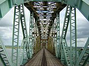
Vila de Sena or more commonly Sena is a town in Mozambique where there is an fundamental bridge over the Zambezi River. This bridge, the Dona Ana Bridge was originally a single track railway bridge, temporarily converted to road operation during the civil war.The town lies on the east bank of the...
and Mutarara in Mozambique
Mozambique
Mozambique, officially the Republic of Mozambique , is a country in southeastern Africa bordered by the Indian Ocean to the east, Tanzania to the north, Malawi and Zambia to the northwest, Zimbabwe to the west and Swaziland and South Africa to the southwest...
, effectively linking the two halves of the country. Built by the Portuguese in 1934 during the Portuguese rule of Mozambique
Portuguese East Africa
Mozambique or Portuguese East Africa was the common name by which the Portuguese Empire's territorial expansion in East Africa was known across different periods of time...
, and blown up by RENAMO soldiers during the Mozambican Civil War
Mozambican Civil War
The Mozambican Civil War began in 1977, two years after the end of the war of independence. The ruling party, Front for Liberation of Mozambique , was violently opposed from 1977 by the Rhodesian- and South African-funded Mozambique Resistance Movement...
(1977-1992), after independence from Portugal
Portugal
Portugal , officially the Portuguese Republic is a country situated in southwestern Europe on the Iberian Peninsula. Portugal is the westernmost country of Europe, and is bordered by the Atlantic Ocean to the West and South and by Spain to the North and East. The Atlantic archipelagos of the...
in 1975, it was originally constructed as a railway bridge to link Malawi
Malawi
The Republic of Malawi is a landlocked country in southeast Africa that was formerly known as Nyasaland. It is bordered by Zambia to the northwest, Tanzania to the northeast, and Mozambique on the east, south and west. The country is separated from Tanzania and Mozambique by Lake Malawi. Its size...
and the Moatize
Moatize
Moatize is a town and district located in Tete Province in Mozambique. It is located near the town of Tete and near the Zambezi River.- Economy :...
coal
Coal
Coal is a combustible black or brownish-black sedimentary rock usually occurring in rock strata in layers or veins called coal beds or coal seams. The harder forms, such as anthracite coal, can be regarded as metamorphic rock because of later exposure to elevated temperature and pressure...
fields to the port of Beira
Beira, Mozambique
Beira is the second largest city in Mozambique. It lies in the central region of the country in Sofala Province, where the Pungue River meets the Indian Ocean. Beira had a population of 412,588 in 1997, which grew to an estimated 546,000 in 2006...
.
History
The 3.67km-long Dona Ana Bridge, at that time the longest railway bridge in AfricaAfrica
Africa is the world's second largest and second most populous continent, after Asia. At about 30.2 million km² including adjacent islands, it covers 6% of the Earth's total surface area and 20.4% of the total land area...
, was built by the Portuguese in 1935 during the Portuguese rule of Mozambique
Portuguese East Africa
Mozambique or Portuguese East Africa was the common name by which the Portuguese Empire's territorial expansion in East Africa was known across different periods of time...
. In the 1980s, during the Mozambican Civil War
Mozambican Civil War
The Mozambican Civil War began in 1977, two years after the end of the war of independence. The ruling party, Front for Liberation of Mozambique , was violently opposed from 1977 by the Rhodesian- and South African-funded Mozambique Resistance Movement...
, it was rendered unusable. In 1995, it was repaired with funds from USAID and converted to a single-lane bridge for vehicle traffic (as shown in the picture). Although not located on a primary highway, it provided an alternative route over the Zambezi; the only other two options were the bridge at Tete
Tete
-External links:* *...
and the road ferry at Caia
Caia, Mozambique
Caia is a town on the south bank of the Zambezi River in Sofala Province, Mozambique. It is a relatively small town with few modern facilities besides a petrol station managed by a Portuguese couple and the neighboring bank...
(which was not always reliable). The Dona Ana Bridge is the longest bridge to cross the Zambezi and was the last before its mouth in the Indian Ocean
Indian Ocean
The Indian Ocean is the third largest of the world's oceanic divisions, covering approximately 20% of the water on the Earth's surface. It is bounded on the north by the Indian Subcontinent and Arabian Peninsula ; on the west by eastern Africa; on the east by Indochina, the Sunda Islands, and...
. However, in 2007, construction started on a bridge to replace the Caia ferry, which (though shorter) would become the last bridge before the mouth. The Caia bridge opened in August 2009. Dona Ana Bridge was closed to vehicular traffic on July 1, 2006, and work to reconvert it to a railway bridge were started, reopening for operation in October 2009.
The bridge comprises 33 spans of 80m and 7 spans of 50m.