

Luangwa River
Encyclopedia

Zambezi
The Zambezi is the fourth-longest river in Africa, and the largest flowing into the Indian Ocean from Africa. The area of its basin is , slightly less than half that of the Nile...
River, and one of the four biggest rivers of Zambia
Zambia
Zambia , officially the Republic of Zambia, is a landlocked country in Southern Africa. The neighbouring countries are the Democratic Republic of the Congo to the north, Tanzania to the north-east, Malawi to the east, Mozambique, Zimbabwe, Botswana and Namibia to the south, and Angola to the west....
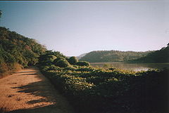
. The river generally floods in the rainy season (December to March) and then falls considerably in the dry season. It is one of the biggest unaltered rivers in Southern Africa and the 20,000 square miles (around 50,000 square kilometers) that make up the surrounding valley are home to abundant wildlife.
Source and Upper-Middle Luangwa Valley
Note: distances stated are approximate straight-line distances from source. The Luwangwa rises in the Lilonda and Mafinga HillsMafinga Hills
The Mafinga Hills are a plateau covered by hills, situated on the border between Zambia and Malawi, in Southern Africa. These hills are composed of quartzites, phyllites and feldspathic sandstones of sedimentary origin....
in north-east Zambia at an elevation of around 1500 m, near the border with Tanzania
Tanzania
The United Republic of Tanzania is a country in East Africa bordered by Kenya and Uganda to the north, Rwanda, Burundi, and the Democratic Republic of the Congo to the west, and Zambia, Malawi, and Mozambique to the south. The country's eastern borders lie on the Indian Ocean.Tanzania is a state...
and Malawi
Malawi
The Republic of Malawi is a landlocked country in southeast Africa that was formerly known as Nyasaland. It is bordered by Zambia to the northwest, Tanzania to the northeast, and Mozambique on the east, south and west. The country is separated from Tanzania and Mozambique by Lake Malawi. Its size...
, and flows in a southwesterly direction through a broad valley. About 150 km from its source it has dropped to an elevation of about 690 m and becomes a meandering river with a flood-plain several kilometres wide. Over the next 300 km the meanders increase, with many oxbow lake
Oxbow lake
An oxbow lake is a U-shaped body of water formed when a wide meander from the main stem of a river is cut off to create a lake. This landform is called an oxbow lake for the distinctive curved shape, named after part of a yoke for oxen. In Australia, an oxbow lake is called a billabong, derived...
s and abandoned meanders. Near Mfuwe
Mfuwe
Mfuwe is the main settlement of South Luangwa National Park in the Eastern Province of Zambia, serving the tourism industry and wildlife conservation in the Luangwa Valley...
, the river's elevation has dropped to about 520 m, the flood plain is about 10 km wide and the valley reaches about 100 km wide, with a north-west escarpment (Muchinga Escarpment) about 700 m high, and a south-western escarpment about 450 m high. In the dry season some sections, especially in the upper reaches, dry out completely, leaving isolated pools.
The upper and middle parts of the valley contain the North Luangwa National Park
North Luangwa National Park
North Luangwa National Park is a national park in Zambia, the northernmost of the three in the valley of the Luangwa River. Founded as a game reserve in 1938, it became a national park in 1972 and now covers 4,636 km²....
and South Luangwa National Park
South Luangwa National Park
South Luangwa National Park in eastern Zambia, the southernmost of three national parks in the valley of the Luangwa River, is a world-renowned wildlife haven. It supports large populations of Thornicroft's Giraffe, and herds of elephant and buffalo often several hundred strong, while the Luangwa...
s of Zambia, which are among some of the finest in Africa. The river itself is home to large populations of hippopotami and crocodile
Crocodile
A crocodile is any species belonging to the family Crocodylidae . The term can also be used more loosely to include all extant members of the order Crocodilia: i.e...
s. The world's largest concentration of hippos lives in the Luangwa Valley. In the dry season they are restricted by the shrinking river and pools, and are easily seen especially in isolated pools.
In the dry season, the grazing land animals and their predators congregate near the river and pools, and are easily seen. In the rainy season they graze further afield and are more easily hidden in the growth of new vegetation.
At about 500 km the valley narrows to about 50 km and becomes divided by a ridge into two parallel valleys, with a tributary, the Lukusashi River in a 25 km-wide valley to the north-west, and the Luangwa in a 15 km wide valley to the southeast. The river meanders less, and the flood plain narrows.
The principal settlement in the Middle and Upper Luangwa Valley is Mfuwe
Mfuwe
Mfuwe is the main settlement of South Luangwa National Park in the Eastern Province of Zambia, serving the tourism industry and wildlife conservation in the Luangwa Valley...
which serves the tourism
Tourism
Tourism is travel for recreational, leisure or business purposes. The World Tourism Organization defines tourists as people "traveling to and staying in places outside their usual environment for not more than one consecutive year for leisure, business and other purposes".Tourism has become a...
industry and has an international airport
Mfuwe Airport
Mfuwe Airport lies near the settlement of Mfuwe, Eastern Province, Zambia . It serves the tourism industry based on the nearby South Luangwa National Park and other wildlife areas in the Luangwa Valley. It has a 2.15 km surfaced runway and takes international flights in the tourist season...
. Very few humans otherwise inhabit the valley.
Lower Luangwa
At 600 km the river abruptly enters a narrow valley between hills rising some 200 m from the broader valley floor, becoming almost a gorge. About 700 km from source the Luangwa merges with its tributary the Lukusashi after the latter has merged with the Lunsemfwa RiverLunsemfwa River
The Lunsemfwa River is a tributary of the Lukasashi and Luangwa Rivers in Zambia and part of the Zambezi River basin. It is a popular river for fishing, containing large populations of tigerfish and bream....
coming from the opposite direction, and turns due south through a steep narrow valley: this is its exit from the Luangwa Rift Valley (see following section). After only 20 km it emerges from the hills into the broad valley of the Zambezi and meanders over sandy flats about 1.5 km wide in a flood plain of 3–5 km wide. It merges with the deeper Zambezi at Luangwa town.
The Luangwa Rift Valley
This section explains the geomorphology of the Luangwa Valley. It is a rift valleyRift valley
A rift valley is a linear-shaped lowland between highlands or mountain ranges created by the action of a geologic rift or fault. This action is manifest as crustal extension, a spreading apart of the surface which is subsequently further deepened by the forces of erosion...
or graben
Graben
In geology, a graben is a depressed block of land bordered by parallel faults. Graben is German for ditch. Graben is used for both the singular and plural....
forming a south-west extension of the Great Rift Valley
Great Rift Valley
The Great Rift Valley is a name given in the late 19th century by British explorer John Walter Gregory to the continuous geographic trench, approximately in length, that runs from northern Syria in Southwest Asia to central Mozambique in South East Africa...
, branching off its Lake Rukwa
Lake Rukwa
Lake Rukwa is a lake in southwestern Tanzania. The alkaline Lake Rukwa lies midway between Lake Tanganyika and Lake Nyasa at an elevation of about 800 metres, in a parallel branch of the rift system. The lake has seen large fluctuations in its size over the years, due to varying inflow of streams...
-Lake Malawi
Lake Malawi
Lake Malawi , is an African Great Lake and the southernmost lake in the Great Rift Valley system of East Africa. This lake, the third largest in Africa and the eighth largest lake in the world, is located between Malawi, Mozambique, and Tanzania...
southern section, and reaching almost as far as Lusaka. The junction is not obvious because it filled with material spewed out from an ancient, extinct volcano. There are at least 20 hot springs, characteristic of a rift valley, in the valley or on its escarpments.
The Luangwa flows along four-fifths of the Luangwa Rift Valley to the point where it meets the Lukusashi and the Lunsemfwa which has come from the opposite direction. At one time, millions of years ago, there was no way out and the Luangwa Rift filled with a Rift Valley Lake
Rift Valley lakes
The Rift Valley lakes are a group of lakes in the Great Rift Valley formed by the East African Rift which runs through the whole eastern side of the African continent from north to south...
called the Madumabisa Lake, which rivalled Lake Malawi
Lake Malawi
Lake Malawi , is an African Great Lake and the southernmost lake in the Great Rift Valley system of East Africa. This lake, the third largest in Africa and the eighth largest lake in the world, is located between Malawi, Mozambique, and Tanzania...
in size. The water of the lake overflowed in a river to the south-west, towards what is now the Kalahari, where it combined with the Okavango
Okavango River
The Okavango River is a river in southwest Africa. It is the fourth-longest river system in southern Africa, running southeastward for . It begins in Angola, where it is known as the Cubango River...
, Upper Zambezi, Cuando
Cuando River
The Cuando River is a river in south-central Africa flowing through Angola and Namibia's Caprivi Strip, into the Linyanti Swamp on the northern border of Botswana...
and Kafue
Kafue River
The Kafue River sustains one of the world's great wildlife environments. It is a major tributary of the Zambezi, and of Zambia's principal rivers, it is the most central and the most urban, and the longest and largest lying wholly within Zambia....
rivers, emptying into the Limpopo River
Limpopo River
The Limpopo River rises in central southern Africa, and flows generally eastwards to the Indian Ocean. It is around long, with a drainage basin in size. Its mean annual discharge is 170 m³/s at its mouth...
and flowing to the Indian Ocean
Indian Ocean
The Indian Ocean is the third largest of the world's oceanic divisions, covering approximately 20% of the water on the Earth's surface. It is bounded on the north by the Indian Subcontinent and Arabian Peninsula ; on the west by eastern Africa; on the east by Indochina, the Sunda Islands, and...
.
Several geological events combined to produce the current river systems. Faulting produced another graben just to the south of the Luangwa Rift, and running east-west: the Zambezi Rift Valley and the Chicoa Trough. A tributary of the Shire River
Shire River
The Shire is a river in Malawi and Mozambique. The river has been known as the Shiré or Chire River. It is the outlet of Lake Malawi and flows into the Zambezi. Its length is 402 km; including Lake Malawi and the Ruhuhu, its headstream, it has a length of about 1200 km...
at the south end of the Great Rift Valley then cut back eastwards through the Chicao Trough and Zambezi Valley, capturing the southerly overspill of the Madumabisa Lake. This tributary became the Zambezi, which over millions of years captured the Kafue, Cuando and the upper Zambezi. Faulting lowered the land between the Luangwa Rift and the Zambezi Rift allowing Madumabisa Lake to drain out into the Zambezi in a channel which became the lower Luangwa River.
The Luangwa as a barrier
The Luangwa Rift Valley and rivers within it form a natural barrier, with a very low population density. This, the steepness of the terrain, and the existence of the wildlife reserves have resulted in no highways crossing the valley between the Lusaka-Kabwe roads in the west and the IsokaIsoka
Isoka is a town located in the Northern Province of Zambia near the borders with Tanzania and Malawi. The district is populated mainly by Winamwanga, but the Wiwa, the Mambwe, the Nyika and the Tumbuka are also found here....
-Chisenga road in the north, a distance of about 800 km. The lower Luangwa Valley is crossed by just one road, the Great East Road at the Luangwa Bridge
Luangwa Bridge
The Luangwa Bridge is the only large bridge and the principal engineering challenge on Zambia's Great East Road, crossing the lower Luangwa River where it flows from the Luangwa Rift Valley into the Zambezi valley....
, about 10 km south of the Luangwa-Lunsemfwa confluence.