
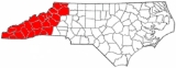
Western North Carolina
Encyclopedia

Region
Region is most commonly found as a term used in terrestrial and astrophysics sciences also an area, notably among the different sub-disciplines of geography, studied by regional geographers. Regions consist of subregions that contain clusters of like areas that are distinctive by their uniformity...
of North Carolina
North Carolina
North Carolina is a state located in the southeastern United States. The state borders South Carolina and Georgia to the south, Tennessee to the west and Virginia to the north. North Carolina contains 100 counties. Its capital is Raleigh, and its largest city is Charlotte...
which includes the Appalachian Mountains
Appalachian Mountains
The Appalachian Mountains #Whether the stressed vowel is or ,#Whether the "ch" is pronounced as a fricative or an affricate , and#Whether the final vowel is the monophthong or the diphthong .), often called the Appalachians, are a system of mountains in eastern North America. The Appalachians...
, thus it is often known geographically
Geography
Geography is the science that studies the lands, features, inhabitants, and phenomena of Earth. A literal translation would be "to describe or write about the Earth". The first person to use the word "geography" was Eratosthenes...
as the state's Mountain Region. It is sometimes included with upstate South Carolina
South Carolina
South Carolina is a state in the Deep South of the United States that borders Georgia to the south, North Carolina to the north, and the Atlantic Ocean to the east. Originally part of the Province of Carolina, the Province of South Carolina was one of the 13 colonies that declared independence...
as the "Western Carolinas", which is also counted as a single media market
Media market
A media market, broadcast market, media region, designated market area , Television Market Area , or simply market is a region where the population can receive the same television and radio station offerings, and may also include other types of media including newspapers and Internet content...
. The region covers an area of about 11000 square miles (28,489.9 km²), and is roughly the size of the state of Massachusetts
Massachusetts
The Commonwealth of Massachusetts is a state in the New England region of the northeastern United States of America. It is bordered by Rhode Island and Connecticut to the south, New York to the west, and Vermont and New Hampshire to the north; at its east lies the Atlantic Ocean. As of the 2010...
. The population of the region, as measured by the 2000 U.S. Census, is 1,015,268.
The term Land of the Sky (or Land-of-Sky) is a common nickname for this mountainous region and has been more recently adopted to refer to the Asheville
Asheville, North Carolina
Asheville is a city in and the county seat of Buncombe County, North Carolina, United States. It is the largest city in Western North Carolina, and the 11th largest city in North Carolina. The City is home to the United States National Climatic Data Center , which is the world's largest active...
area. (Areas in the northwest portion of the region, including Boone
Boone, North Carolina
Boone is a town located in the Blue Ridge Mountains of western North Carolina, United States. Boone's population was reported as 17,122, as of 2010...
and Blowing Rock
Blowing Rock, North Carolina
Blowing Rock is a town in North Carolina, USA, situated in both Caldwell and Watauga counties. The population was 1,418 at the 2000 census. However, during the summer the town's population increases to about 10,000.]]\\...
, commonly use the nickname "The High Country", rather than "Land of the Sky") The term is derived from the title of the book, Land of the Sky
Land of the Sky
The Land of the Sky, or, adventures in mountain by-ways is a novel by Mrs. Frances Tiernan, under the pseudonym Christian Reid. It was published in 1876.The name refers to the Blue Ridge Mountains and Great Smoky Mountains in western North Carolina...
, written by Mrs. Frances Tiernan, under the pseudonym Christian Reid. The book often mentions the Great Smoky Mountains
Great Smoky Mountains
The Great Smoky Mountains are a mountain range rising along the Tennessee–North Carolina border in the southeastern United States. They are a subrange of the Appalachian Mountains, and form part of the Blue Ridge Physiographic Province. The range is sometimes called the Smoky Mountains or the...
and Blue Ridge Mountains
Blue Ridge Mountains
The Blue Ridge Mountains are a physiographic province of the larger Appalachian Mountains range. This province consists of northern and southern physiographic regions, which divide near the Roanoke River gap. The mountain range is located in the eastern United States, starting at its southern-most...
, the two main ranges
Mountain range
A mountain range is a single, large mass consisting of a succession of mountains or narrowly spaced mountain ridges, with or without peaks, closely related in position, direction, formation, and age; a component part of a mountain system or of a mountain chain...
that are found in Western North Carolina. The Asheville area regional government body, the Land-of-Sky Regional Council
Land-of-Sky Regional Council
The Land-of-Sky Regional Council is one of the 17 regional North Carolina Councils of Governments established by the North Carolina General Assembly for the purpose of regional planning and administration. Headquartered in Asheville, North Carolina, it serves Madison, Buncombe, Henderson, and...
, utilizes the nickname.
Located east of the Tennessee
Tennessee
Tennessee is a U.S. state located in the Southeastern United States. It has a population of 6,346,105, making it the nation's 17th-largest state by population, and covers , making it the 36th-largest by total land area...
state line and west of the Piedmont
Piedmont (United States)
The Piedmont is a plateau region located in the eastern United States between the Atlantic Coastal Plain and the main Appalachian Mountains, stretching from New Jersey in the north to central Alabama in the south. The Piedmont province is a physiographic province of the larger Appalachian division...
, Western North Carolina contains very few major urban centers. Asheville, North Carolina
Asheville, North Carolina
Asheville is a city in and the county seat of Buncombe County, North Carolina, United States. It is the largest city in Western North Carolina, and the 11th largest city in North Carolina. The City is home to the United States National Climatic Data Center , which is the world's largest active...
, located in the region's center, is the area's largest city and most prominent commercial hub. The Foothills region of the state is loosely defined as the area along Western North Carolina's eastern boundary; this region consists of a transitional terrain of hills between the Appalachians and the Piedmont Plateau of central North Carolina. The Eastern Band of Cherokee Indians
Eastern Band of Cherokee Indians
The Eastern Band of Cherokee Indians , is a federally recognized Native American tribe in the United States of America, who are descended from Cherokee who remained in the Eastern United States while others moved, or were forced to relocate, to the west in the 19th century. The history of the...
have a reservation
Indian reservation
An American Indian reservation is an area of land managed by a Native American tribe under the United States Department of the Interior's Bureau of Indian Affairs...
situated in the Western North Carolina region, adjacent to the Great Smoky Mountains National Park
Great Smoky Mountains National Park
Great Smoky Mountains National Park is a United States National Park and UNESCO World Heritage Site that straddles the ridgeline of the Great Smoky Mountains, part of the Blue Ridge Mountains, which are a division of the larger Appalachian Mountain chain. The border between Tennessee and North...
.
Subregions
High Country
The northern counties in Western North Carolina are commonly known as the state's High Country. Centered around Boone, the High Country boasts the area's most popular ski resortSki resort
A ski resort is a resort developed for skiing and other winter sports. In Europe a ski resort is a town or village in a ski area - a mountainous area, where there are ski trails and supporting services such as hotels and other accommodation, restaurants, equipment rental and a ski lift system...
s, including Ski Beech
Beech Mountain, North Carolina
For the geographical feature, see Beech MountainBeech Mountain is the highest town east of the Rocky Mountains, located in both Avery and Watauga counties in the U.S. state of North Carolina. The population was 310 at the 2000 census...
, Appalachian Ski Mountain, and Sugar Mountain. The area also features many attractions, historical sites, and geological formations such as Linville Caverns
Linville Caverns
Linville Caverns are privately owned active limestone caverns located in northern McDowell County, North Carolina, just south of the village of Linville Falls, on U.S. Highway 221. The caverns are open to the public year round for guided tours...
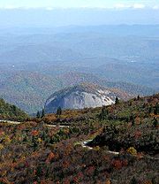
, Grandfather Mountain
Grandfather Mountain
Grandfather Mountain is a mountain, a non-profit attraction, and a North Carolina state parknear Linville, North Carolina. At 5,946 feet , it is the highest peak on the eastern escarpment of the Blue Ridge Mountains, one of the major chains of the Appalachian Mountains. The Blue Ridge Parkway...
, Blowing Rock
Blowing Rock (land feature)
Blowing Rock is a rocky outcropping at the town of Blowing Rock, North Carolina, above a gorge in Caldwell County, in the northwest of that state.The prevailing wind blows through the gorge toward Blowing Rock...
, Tweetsie Railroad
Tweetsie Railroad
Tweetsie Railroad is a family oriented railroad and Wild West theme park located between Boone and Blowing Rock, North Carolina, United States. In addition to a ride aboard an authentic steam locomotive, the park features amusement rides and other attractions geared towards families with...
, Glendale Springs Inn, Shatley Springs, and Mystery Hill. Education, skiing tourism, and Christmas tree
Christmas tree
The Christmas tree is a decorated evergreen coniferous tree, real or artificial, and a tradition associated with the celebration of Christmas. The tradition of decorating an evergreen tree at Christmas started in Livonia and Germany in the 16th century...
farming are among this area's most prominent industries, although agriculture
Agriculture
Agriculture is the cultivation of animals, plants, fungi and other life forms for food, fiber, and other products used to sustain life. Agriculture was the key implement in the rise of sedentary human civilization, whereby farming of domesticated species created food surpluses that nurtured the...
and raising livestock
Livestock
Livestock refers to one or more domesticated animals raised in an agricultural setting to produce commodities such as food, fiber and labor. The term "livestock" as used in this article does not include poultry or farmed fish; however the inclusion of these, especially poultry, within the meaning...
also remain important.
Tennessee Valley
The westernmost part of Western North Carolina is part of the Tennessee Valley. Asheville is the major hub of far western North Carolina. In this area, there are a few hydroelectric projects managed by the Tennessee Valley AuthorityTennessee Valley Authority
The Tennessee Valley Authority is a federally owned corporation in the United States created by congressional charter in May 1933 to provide navigation, flood control, electricity generation, fertilizer manufacturing, and economic development in the Tennessee Valley, a region particularly affected...
, including Fontana Dam
Fontana Dam
Fontana Dam is a hydroelectric dam on the Little Tennessee River in Swain and Graham counties, North Carolina, USA. The dam is operated by the Tennessee Valley Authority, which built the dam in the early 1940s to accommodate the skyrocketing electricity demands in the Tennessee Valley at the...
. Tourism, especially outdoor ventures such as canoeing, whitewater rafting, camping, and fishing are extremely important to local economies in the area.
Foothills
The Foothills is a regionRegion
Region is most commonly found as a term used in terrestrial and astrophysics sciences also an area, notably among the different sub-disciplines of geography, studied by regional geographers. Regions consist of subregions that contain clusters of like areas that are distinctive by their uniformity...
of transitional terrain between the Piedmont Plateau and the Appalachian Mountains
Appalachian Mountains
The Appalachian Mountains #Whether the stressed vowel is or ,#Whether the "ch" is pronounced as a fricative or an affricate , and#Whether the final vowel is the monophthong or the diphthong .), often called the Appalachians, are a system of mountains in eastern North America. The Appalachians...
, extending from the lower edge of the Blue Ridge escarpment into the upper Catawba, Yadkin, and Broad River valleys. The eastern slopes of the Blue Ridge drop sharply to the foothills section, going from 3500–4000 feet (1,000–1,200 m) at the top to only 1000-1500 feet at the base. The foothills region contains numerous lower peaks and isolated mountain ranges such as the South Mountains
South Mountains (North Carolina)
The South Mountains are an ancient and deeply eroded mountain range in western North Carolina. They are an isolated remnant of the much larger Appalachian Mountains to the west, and are separated from the Appalachians by the Catawba River valley. The range covers approximately 100,000 acres in...
, Brushy Mountains
Brushy Mountains (North Carolina)
The Brushy Mountains are a mountain range located in northwestern North Carolina. They are an isolated "spur" of the much larger Blue Ridge Mountains, separated from them by the Yadkin River valley...
, and Stone Mountain State Park
Stone Mountain State Park
Stone Mountain State Park is a North Carolina state park in Alleghany and Wilkes Counties, North Carolina in the United States.-Size and location:Located in Wilkes and Alleghany counties of North Carolina, it covers 13,747 acres ....
. The foothills are divided into many small river and creek valleys that contain much of the region's population. Although no large cities are located in the foothills, the region does contain many small towns; the towns often developed around a single industry such as furniture
Furniture
Furniture is the mass noun for the movable objects intended to support various human activities such as seating and sleeping in beds, to hold objects at a convenient height for work using horizontal surfaces above the ground, or to store things...
or textiles. As these industries steadily moved to low-wage markets in Asia
Asia
Asia is the world's largest and most populous continent, located primarily in the eastern and northern hemispheres. It covers 8.7% of the Earth's total surface area and with approximately 3.879 billion people, it hosts 60% of the world's current human population...
and Latin America
Latin America
Latin America is a region of the Americas where Romance languages – particularly Spanish and Portuguese, and variably French – are primarily spoken. Latin America has an area of approximately 21,069,500 km² , almost 3.9% of the Earth's surface or 14.1% of its land surface area...
over the last quarter-century, the foothills towns that depended upon them have often suffered from job and population loss; some of these towns are developing a new economy based on tourism
Tourism
Tourism is travel for recreational, leisure or business purposes. The World Tourism Organization defines tourists as people "traveling to and staying in places outside their usual environment for not more than one consecutive year for leisure, business and other purposes".Tourism has become a...
and catering to affluent retirees who have settled in the region. Many farmers in the northern foothills are poultry
Poultry
Poultry are domesticated birds kept by humans for the purpose of producing eggs, meat, and/or feathers. These most typically are members of the superorder Galloanserae , especially the order Galliformes and the family Anatidae , commonly known as "waterfowl"...
farmers as well, and winemaking
Winemaking
Winemaking, or vinification, is the production of wine, starting with selection of the grapes or other produce and ending with bottling the finished wine. Although most wine is made from grapes, it may also be made from other fruit or non-toxic plant material...
and vineyard
Vineyard
A vineyard is a plantation of grape-bearing vines, grown mainly for winemaking, but also raisins, table grapes and non-alcoholic grape juice...
s are growing in popularity. Among the towns of the foothills region in North Carolina are Tryon
Tryon, North Carolina
Tryon is a town in Polk County, North Carolina, United States. According to the 2000 Census the population of Tryon was 1,760. The area is a center for equestrian activity and fine arts....
, Columbus
Columbus, North Carolina
Columbus is a town in Polk County, North Carolina, United States. The population was 992 at the 2000 census. It is the county seat of Polk County.-Geography:Columbus is located at ....
, Chimney Rock
Chimney Rock, North Carolina
Chimney Rock is a village in Rutherford County, North Carolina, United States. The population was 175 at the 2000 census. The village takes its name from a large granite outcropping located on a summit above the village itself in Chimney Rock State Park....
, Lake Lure
Lake Lure, North Carolina
-History:In 1902, Dr. Lucius B. Morse and his brothers Hiram and Asahel purchased around Chimney Rock for $5,000. They later acquired enough land in the area to bring the total to...
, Forest City
Forest City, North Carolina
Forest City, formerly known as "Burnt Chimney," is a town in Rutherford County, North Carolina, United States. The population was 7,549 as of the 2000 census.-Geography:Forest City is located at ....
, Rutherfordton
Rutherfordton, North Carolina
Rutherfordton is a town in Rutherford County, North Carolina, United States. The population was 4,131 at the 2000 census. It is the county seat of Rutherford County.-Geography:Rutherfordton is located at ....
, Spindale
Spindale, North Carolina
Spindale is a town in Rutherford County, North Carolina, United States. The population was 4,022 at the 2000 census.-Geography:Spindale is located at .According to the United States Census Bureau, the town has a total area of , all of it land....
, Mount Airy
Mount Airy, North Carolina
Mount Airy is a city in Surry County, North Carolina, United States. As of the 2010 census, the city population was 10,388.-History:Mount Airy was settled in the 1750s as a stagecoach stop on the road between Winston-Salem and Galax, Virginia. It was named for a nearby plantation...
, Elkin
Elkin, North Carolina
Elkin is a town in Surry and Wilkes counties in the U.S. state of North Carolina, along the Yadkin River. Elkin shares its name with the surrounding township of Elkin Township...
, and Marion
Marion, North Carolina
Marion is a city in McDowell County, North Carolina, United States. The population was 7,943 at the 2008 estimated census. It is the county seat of McDowell County.-Geography:Marion is located at ....
and the cities of North Wilkesboro
North Wilkesboro, North Carolina
North Wilkesboro is a town in Wilkes County, North Carolina, United States. The population was approximately 4,116 at the 2000 census and is now 4,245 as of the 2010 census. North Wilkesboro is the birthplace and original home of Lowe's Home Improvement, which continues to have a major presence in...
, Wilkesboro
Wilkesboro, North Carolina
Wilkesboro is a town in and the county seat of Wilkes County, North Carolina, United States. The population was 3,159 at the 2000 census, and it is the second largest municipality in the county. The 2010 Census listed the town's population at 3,044. The town is located along the south bank of the...
, Hickory
Hickory, North Carolina
Hickory is a city in Catawba County, North Carolina. Hickory has the 162nd largest urban area in the United States. As of the 2000 census, the Metropolitan Statistical Area had a population of 341,851, making it the 4th largest metropolitan area in North Carolina. The city's population was 37,222...
, Lenoir
Lenoir, North Carolina
Lenoir is a city in Caldwell County, North Carolina, United States. The population was 18,228 at the 2010 census. It is the county seat of Caldwell County. Lenoir is located in the Blue Ridge foothills. The city also contains the Brushy Mountains, a spur of the Blue Ridge Mountains...
, Wilkesboro
Wilkesboro, North Carolina
Wilkesboro is a town in and the county seat of Wilkes County, North Carolina, United States. The population was 3,159 at the 2000 census, and it is the second largest municipality in the county. The 2010 Census listed the town's population at 3,044. The town is located along the south bank of the...
, and Morganton
Morganton, North Carolina
Morganton is a city in Burke County, North Carolina, United States. Reader's Digest included Morganton in its list of top ten places to raise a family. The town was recently profiled in The 50 Best Small Southern Towns. The population was 17,310 at the 2000 census...
.
Higher education
Western Carolina UniversityWestern Carolina University
Western Carolina University is a coeducational public university located in Cullowhee, North Carolina, United States. The university is a constituent campus of the University of North Carolina system....
has three campus
Campus
A campus is traditionally the land on which a college or university and related institutional buildings are situated. Usually a campus includes libraries, lecture halls, residence halls and park-like settings...
es in western North Carolina. Appalachian State University
Appalachian State University
Appalachian State University is a comprehensive , public, coeducational university located in Boone, North Carolina, United States. Appalachian State, also referred to as Appalachian, App State, or simply App, is the sixth largest institution in the University of North Carolina system...
in Boone and UNC Asheville are the region's other two public universities. Several liberal-arts colleges are also located in the region. Mars Hill College
Mars Hill College
Mars Hill College is a private, coed, liberal-arts college affiliated with the Baptist State Convention of North Carolina and the Cooperative Baptist Fellowship. The college is located in the small town of Mars Hill, North Carolina, due north of Asheville, western North Carolina's largest city...
, affiliated with the North Carolina Baptist
Baptist
Baptists comprise a group of Christian denominations and churches that subscribe to a doctrine that baptism should be performed only for professing believers , and that it must be done by immersion...
Convention, is located 15 miles (24.1 km) north of Asheville. Founded in 1856, it is the oldest college or university in western North Carolina. Montreat College
Montreat College
Montreat College is a private, four-year, liberal arts Christian college with campuses located in Black Mountain, Asheville and Charlotte, North Carolina, United States and its primary campus in Montreat, North Carolina. The college offers on-campus traditional four-year degrees, an adult studies...
, affiliated with the Presbyterian Church, is located 15 miles (24.1 km) east of Asheville. Lees-McRae College
Lees-McRae College
Lees-McRae College is a private four-year college in Banner Elk, North Carolina affiliated with the Presbyterian Church . Lees-McRae College has the highest elevation of any college or university in the United States east of the Mississippi River at above sea level. It is one of the few colleges...
, located near Banner Elk, North Carolina
Banner Elk, North Carolina
-Attractions:During summer time there is hiking, whitewater rafting, fishing, and other activities. The largest lake in the area, Watauga Lake, is a favorite spot just 30 minutes away for boating, fishing and wake boarding. In the winter the main event is skiing and snowboarding. There are two...
, is also affiliated with the Presbyterian Church. Warren Wilson College
Warren Wilson College
Warren Wilson College is a private four-year work college in the Swannanoa Valley, North Carolina, United States near Asheville. It is known for its curriculum of work, academics, and service, called "the Triad," which requires every student to work an on-campus job, perform at least one hundred...
, located in Swannanoa
Swannanoa, North Carolina
Swannanoa is a census-designated place in Buncombe County, North Carolina, United States. The population was 4,526 in 2007. The community is named for the Swannanoa River, which flows through the settlement. It is part of the Asheville Metropolitan Statistical Area.Swannanoa is located between...
, is noted for its strong pro-environment policies and social liberalism
Social liberalism
Social liberalism is the belief that liberalism should include social justice. It differs from classical liberalism in that it believes the legitimate role of the state includes addressing economic and social issues such as unemployment, health care, and education while simultaneously expanding...
. Brevard College
Brevard College
Brevard College is a small, private, United Methodist, liberal arts college in Brevard, North Carolina. The college currently grants the Bachelor of Arts, Bachelor of Science, or Bachelor of Music degree...
, located in Brevard, North Carolina
Brevard, North Carolina
Brevard is a town in Transylvania County, North Carolina, United States. The 2005 population estimate by the United States Census Bureau was 6,643. It is the county seat of Transylvania County....
, is affiliated with the United Methodist Church
United Methodist Church
The United Methodist Church is a Methodist Christian denomination which is both mainline Protestant and evangelical. Founded in 1968 by the union of The Methodist Church and the Evangelical United Brethren Church, the UMC traces its roots back to the revival movement of John and Charles Wesley...
. Lenoir-Rhyne University, located in Hickory, is a private liberal arts university affiliated with the Evangelical Lutheran Church in America
Evangelical Lutheran Church in America
The Evangelical Lutheran Church in America is a mainline Protestant denomination headquartered in Chicago, Illinois. The ELCA officially came into existence on January 1, 1988, by the merging of three churches. As of December 31, 2009, it had 4,543,037 baptized members, with 2,527,941 of them...
.
Transportation
Three major Interstate highways cross the region: Interstate 40Interstate 40
Interstate 40 is the third-longest major east–west Interstate Highway in the United States, after I-90 and I-80. Its western end is at Interstate 15 in Barstow, California; its eastern end is at a concurrency of U.S. Route 117 and North Carolina Highway 132 in Wilmington, North Carolina...
, which traverses east-west, Interstate 77
Interstate 77
Interstate 77 is an Interstate Highway in the eastern United States. It traverses diverse terrain, from the mountainous state of West Virginia to the rolling farmlands of North Carolina and Ohio. It largely supplants the old U.S...
, which runs north-south through the northeastern section of Western North Carolina, and Interstate 26
Interstate 26
Interstate 26 is a nominally east–west main route of the Interstate Highway System in the Southeastern United States. I-26 runs from the junction of U.S. Route 11W and U.S. Route 23 in Kingsport, Tennessee, generally southeastward to U.S. Route 17 in Charleston, South Carolina...
, which traverses north-south. Interstate 240
Interstate 240 (North Carolina)
Interstate 240 is a long Interstate Highway loop in the U.S. state of North Carolina. It serves as an urban connector for Asheville and runs in a half-circle around the north of the city's downtown district between exits 53B and 46B of Interstate 40...
is the only auxiliary interstate route
Auxiliary route
In road transportation, a special route is a prefixed and/or suffixed numbered road that forms a loop or spur of a more dominant route of the same route number and system. The dominant route is generally referred to as the "parent" or "mainline", while special routes are also unofficially or...
in the region and it serves downtown Asheville. Highway US 421, a multilane expressway, is the major highway in the northwestern part of the state, and US 74, US 64, US 19, US 23, and US 441 are the major highways in the far western part of the region. Highway US 321 runs north from Hickory to Watauga and Avery Counties before going into Tennessee. A National Scenic Byway
National Scenic Byway
A National Scenic Byway is a road recognized by the United States Department of Transportation for its archeological, cultural, historic, natural, recreational, and/or scenic qualities. The program was established by Congress in 1991 to preserve and protect the nation's scenic but often...
, the Blue Ridge Parkway
Blue Ridge Parkway
The Blue Ridge Parkway is a National Parkway and All-American Road in the United States, noted for its scenic beauty. It runs for 469 miles , mostly along the famous Blue Ridge, a major mountain chain that is part of the Appalachian Mountains...
, runs through western North Carolina, ending near the Great Smoky Mountains National Park
Great Smoky Mountains National Park
Great Smoky Mountains National Park is a United States National Park and UNESCO World Heritage Site that straddles the ridgeline of the Great Smoky Mountains, part of the Blue Ridge Mountains, which are a division of the larger Appalachian Mountain chain. The border between Tennessee and North...
. Two major class 1 railroads run through the region, CSX and Norfolk Southern. In addition, two tourist railroads also operate in the area, the Tweetsie Railroad theme park
Tweetsie Railroad
Tweetsie Railroad is a family oriented railroad and Wild West theme park located between Boone and Blowing Rock, North Carolina, United States. In addition to a ride aboard an authentic steam locomotive, the park features amusement rides and other attractions geared towards families with...
and the Great Smoky Mountains Railroad
Great Smoky Mountains Railroad
The Great Smoky Mountains Railroad is a freight and heritage railroad in North Carolina with a depot in Bryson City. The railroad operates over the western leg of the "Murphy Branch", a former branch line of the Southern Railway....
.
Asheville Regional Airport
Asheville Regional Airport
Asheville Regional Airport is a Class C airport near Interstate 40 and Interstate 26 near the town of Fletcher, south of the city of Asheville, in the U.S. state of North Carolina. It is owned by the city of Asheville...
(AVL), located southeast of the city of Asheville in Fletcher
Fletcher, North Carolina
Fletcher is a town in Henderson County, North Carolina, United States. The population was 4,185 at the 2000 census.Fletcher is home to Asheville Regional Airport, which serves Western North Carolina...
, also serves the area with non-stop jet service to Charlotte, North Carolina
Charlotte, North Carolina
Charlotte is the largest city in the U.S. state of North Carolina and the seat of Mecklenburg County. In 2010, Charlotte's population according to the US Census Bureau was 731,424, making it the 17th largest city in the United States based on population. The Charlotte metropolitan area had a 2009...
; Newark, New Jersey
Newark, New Jersey
Newark is the largest city in the American state of New Jersey, and the seat of Essex County. As of the 2010 United States Census, Newark had a population of 277,140, maintaining its status as the largest municipality in New Jersey. It is the 68th largest city in the U.S...
; Houston, Texas
Texas
Texas is the second largest U.S. state by both area and population, and the largest state by area in the contiguous United States.The name, based on the Caddo word "Tejas" meaning "friends" or "allies", was applied by the Spanish to the Caddo themselves and to the region of their settlement in...
; Atlanta, Georgia
Atlanta, Georgia
Atlanta is the capital and most populous city in the U.S. state of Georgia. According to the 2010 census, Atlanta's population is 420,003. Atlanta is the cultural and economic center of the Atlanta metropolitan area, which is home to 5,268,860 people and is the ninth largest metropolitan area in...
; Orlando, Florida
Orlando, Florida
Orlando is a city in the central region of the U.S. state of Florida. It is the county seat of Orange County, and the center of the Greater Orlando metropolitan area. According to the 2010 US Census, the city had a population of 238,300, making Orlando the 79th largest city in the United States...
; Detroit, Michigan
Michigan
Michigan is a U.S. state located in the Great Lakes Region of the United States of America. The name Michigan is the French form of the Ojibwa word mishigamaa, meaning "large water" or "large lake"....
; O'Hare International Airport
O'Hare International Airport
Chicago O'Hare International Airport , also known as O'Hare Airport, O'Hare Field, Chicago Airport, Chicago International Airport, or simply O'Hare, is a major airport located in the northwestern-most corner of Chicago, Illinois, United States, northwest of the Chicago Loop...
in Chicago
Chicago
Chicago is the largest city in the US state of Illinois. With nearly 2.7 million residents, it is the most populous city in the Midwestern United States and the third most populous in the US, after New York City and Los Angeles...
, Illinois
Illinois
Illinois is the fifth-most populous state of the United States of America, and is often noted for being a microcosm of the entire country. With Chicago in the northeast, small industrial cities and great agricultural productivity in central and northern Illinois, and natural resources like coal,...
; Tampa, Florida
Tampa, Florida
Tampa is a city in the U.S. state of Florida. It serves as the county seat for Hillsborough County. Tampa is located on the west coast of Florida. The population of Tampa in 2010 was 335,709....
; and LaGuardia Airport
LaGuardia Airport
LaGuardia Airport is an airport located in the northern part of Queens County on Long Island in the City of New York. The airport is located on the waterfront of Flushing Bay and Bowery Bay, and borders the neighborhoods of Astoria, Jackson Heights and East Elmhurst. The airport was originally...
in New York City
New York City
New York is the most populous city in the United States and the center of the New York Metropolitan Area, one of the most populous metropolitan areas in the world. New York exerts a significant impact upon global commerce, finance, media, art, fashion, research, technology, education, and...
.
Economy
TourismTourism
Tourism is travel for recreational, leisure or business purposes. The World Tourism Organization defines tourists as people "traveling to and staying in places outside their usual environment for not more than one consecutive year for leisure, business and other purposes".Tourism has become a...
is a major part of the economy
Economy
An economy consists of the economic system of a country or other area; the labor, capital and land resources; and the manufacturing, trade, distribution, and consumption of goods and services of that area...
in the area which contains half of the Great Smoky Mountains National Park
Great Smoky Mountains National Park
Great Smoky Mountains National Park is a United States National Park and UNESCO World Heritage Site that straddles the ridgeline of the Great Smoky Mountains, part of the Blue Ridge Mountains, which are a division of the larger Appalachian Mountain chain. The border between Tennessee and North...
as well as the Nantahala
Nantahala National Forest
The Nantahala National Forest, established in 1920, is a national forest located in the American state of North Carolina. The word "Nantahala" is a Cherokee word meaning "Land of the Noonday Sun." The name is appropriate as, in some spots, the sun only reaches the floors of the deep gorges of the...
and Pisgah National Forest
Pisgah National Forest
Pisgah National Forest is a National Forest in the Appalachian Mountains of western North Carolina. It is administered by the United States Forest Service, part of the United States Department of Agriculture. The Pisgah National Forest is completely contained within the state of North Carolina...
s. There are also several lake
Lake
A lake is a body of relatively still fresh or salt water of considerable size, localized in a basin, that is surrounded by land. Lakes are inland and not part of the ocean and therefore are distinct from lagoons, and are larger and deeper than ponds. Lakes can be contrasted with rivers or streams,...
s and dam
Dam
A dam is a barrier that impounds water or underground streams. Dams generally serve the primary purpose of retaining water, while other structures such as floodgates or levees are used to manage or prevent water flow into specific land regions. Hydropower and pumped-storage hydroelectricity are...
s scattered throughout Western North Carolina like Lake Lure and Fontana Dam
Fontana Dam
Fontana Dam is a hydroelectric dam on the Little Tennessee River in Swain and Graham counties, North Carolina, USA. The dam is operated by the Tennessee Valley Authority, which built the dam in the early 1940s to accommodate the skyrocketing electricity demands in the Tennessee Valley at the...
. Many visitors travel to the region every summer and autumn from major cities like Charlotte, Atlanta and Knoxville, to escape the hot weather
Weather
Weather is the state of the atmosphere, to the degree that it is hot or cold, wet or dry, calm or stormy, clear or cloudy. Most weather phenomena occur in the troposphere, just below the stratosphere. Weather refers, generally, to day-to-day temperature and precipitation activity, whereas climate...
and see the leaves change colors. The timber industry is also a major economic sector.
Appalachian Regional Commission

The Appalachian Regional Commission
Appalachian Regional Commission
The Appalachian Regional Commission is a United States federal-state partnership that works with the people of Appalachia to create opportunities for self-sustaining economic development and improved quality of life...
was formed in 1965 to aid economic development in the Appalachian region, which was lagging far behind the rest of the nation on most economic indicators. The Appalachian region currently defined by the Commission includes 420 counties in 13 states, including 29 counties in North Carolina. The Commission gives each county one of five possible economic designations— distressed, at-risk, transitional, competitive, or attainment— with "distressed" counties being the most economically endangered and "attainment" counties being the most economically prosperous. These designations are based primarily on three indicators— three-year average unemployment rate, market income per capita, and poverty rate.
In 2003, Appalachian North Carolina— which included all 24 counties of Western North Carolina and five counties in central North Carolina— had a three-year average unemployment rate of 6%, compared with 6.2% statewide and 5.5% nationwide. In 2002, Appalachian North Carolina had a per capita market income of $21,168, compared with $23,443 statewide and $26,420 nationwide. In 2000, Appalachian North Carolina had a poverty rate of 11.7%, compared to 12.3% statewide and 12.4% nationwide.
Only one North Carolina county— Graham— was designated "Distressed," while six— Cherokee, McDowell, Mitchell, Rutherford, Swain, and Yancey— were designated "at-risk." Forsyth County (which is normally grouped with central North Carolina) was the only county given the "attainment" designation, and four others— Buncombe, Davie, Henderson, and Polk— were designated "competitive." Most Western North Carolina counties were designated "transitional," meaning they lagged behind the national average on one of the three key indicators. Graham County had Appalachian North Carolina's highest poverty rating, with 19.5% of its residents living below the poverty line. Forsyth had Appalachian North Carolina's highest per capita income at $26,987. Watauga County's unemployment rate of 2.3% was lowest of all 420 counties in the Appalachian region.
Topography
There are 82 mountainMountain
Image:Himalaya_annotated.jpg|thumb|right|The Himalayan mountain range with Mount Everestrect 58 14 160 49 Chomo Lonzorect 200 28 335 52 Makalurect 378 24 566 45 Mount Everestrect 188 581 920 656 Tibetan Plateaurect 250 406 340 427 Rong River...
peak
Summit (topography)
In topography, a summit is a point on a surface that is higher in elevation than all points immediately adjacent to it. Mathematically, a summit is a local maximum in elevation...
s between 5,000 to 6,000 feet (1,500-1,800 m) in elevation
Elevation
The elevation of a geographic location is its height above a fixed reference point, most commonly a reference geoid, a mathematical model of the Earth's sea level as an equipotential gravitational surface ....
in western North Carolina, and 43 peaks rise to over 6000 feet (1,828.8 m). Mount Mitchell
Mount Mitchell (North Carolina)
Mount Mitchell is the highest peak of the Appalachian Mountains and the highest peak in the eastern United States. It was the highest point in any state of the United States until Texas joined the union in 1845. The nearest higher point east of the Rocky Mountains is Harney Peak in the Black Hills...
, 6684 feet (2,037.3 m), is the highest point in eastern North America
North America
North America is a continent wholly within the Northern Hemisphere and almost wholly within the Western Hemisphere. It is also considered a northern subcontinent of the Americas...
. Valley
Valley
In geology, a valley or dale is a depression with predominant extent in one direction. A very deep river valley may be called a canyon or gorge.The terms U-shaped and V-shaped are descriptive terms of geography to characterize the form of valleys...
locations are typically closer to 2000 feet (609.6 m) AMSL.
The French Broad River
French Broad River
The French Broad River flows from near the village of Rosman in Transylvania County, North Carolina, into the state of Tennessee. Its confluence with the Holston River at Knoxville is the beginning of the Tennessee River....
is the largest river
River
A river is a natural watercourse, usually freshwater, flowing towards an ocean, a lake, a sea, or another river. In a few cases, a river simply flows into the ground or dries up completely before reaching another body of water. Small rivers may also be called by several other names, including...
in the region; others include the Little Tennessee River
Little Tennessee River
The Little Tennessee River is a tributary of the Tennessee River, approximately 135 miles long, in the Appalachian Mountains in the southeastern United States.-Geography:...
and Swannanoa River
Swannanoa River
The Swannanoa River flows through the Swannanoa Valley of western North Carolina, and is a major tributary to the French Broad River. It begins at its headwaters in Black Mountain, NC, however, it also has a major tributary near its headwaters: Flat Creek, which begins on the slopes of Mount...
. The Eastern Continental Divide
Eastern Continental Divide
The Eastern Continental Divide, in conjunction with other continental divides of North America, demarcates two watersheds of the Atlantic Ocean: the Gulf of Mexico watershed and the Atlantic Seaboard watershed. Prior to 1760, the divide represented the boundary between British and French colonial...
runs through the region, dividing Tennessee
Tennessee
Tennessee is a U.S. state located in the Southeastern United States. It has a population of 6,346,105, making it the nation's 17th-largest state by population, and covers , making it the 36th-largest by total land area...
-bound stream
Stream
A stream is a body of water with a current, confined within a bed and stream banks. Depending on its locale or certain characteristics, a stream may be referred to as a branch, brook, beck, burn, creek, "crick", gill , kill, lick, rill, river, syke, bayou, rivulet, streamage, wash, run or...
s from those flowing through the Carolinas.
Counties
Western North Carolina generally consists of 26 counties, that when combined form a total regional area of roughly 9700 square miles (25,122.9 km²) the region is roughly the size of VermontVermont
Vermont is a state in the New England region of the northeastern United States of America. The state ranks 43rd in land area, , and 45th in total area. Its population according to the 2010 census, 630,337, is the second smallest in the country, larger only than Wyoming. It is the only New England...
or New Hampshire
New Hampshire
New Hampshire is a state in the New England region of the northeastern United States of America. The state was named after the southern English county of Hampshire. It is bordered by Massachusetts to the south, Vermont to the west, Maine and the Atlantic Ocean to the east, and the Canadian...
. The counties commonly included in the region are as follows:
- Alexander CountyAlexander County, North Carolina-Demographics:As of the census of 2000, there were 33,603 people, 13,137 households, and 9,747 families residing in the county. The population density was 129 people per square mile . There were 14,098 housing units at an average density of 54 per square mile...
- Alleghany CountyAlleghany County, North Carolina-Major highways:* U.S. Highway 21* U.S. Highway 221* North Carolina Highway 18* North Carolina Highway 88* North Carolina Highway 93* North Carolina Highway 113-Demographics:...
- Ashe CountyAshe County, North Carolina- History :Historical evidence shows that Ashe county was inhabited by Native Americans, which included the Cherokee, Creek, and Shawnee tribes. Pieces of broken pottery, arrowheads, and other Native American artifacts have been found, indicating their presence...
- Avery CountyAvery County, North Carolina- Climate :As a result of its relatively high elevation, Avery County has a Humid continental climate enjoying considerably cooler summers than most of the rest of the Eastern US. Likewise, winters are longer, colder and snowier than most other locations in the region. This can be evidenced by the...
- Buncombe CountyBuncombe County, North Carolina-Demographics:As of the census of 2000, there were 206,330 people, 85,776 households, and 55,668 families residing in the county. The population density was 314 people per square mile . There were 93,973 housing units at an average density of 143 per square mile...
- Burke CountyBurke County, North Carolina-Demographics:As of the census of 2000, there were 89,148 people, 34,528 households, and 24,342 families residing in the county. The population density was 176 people per square mile . There were 37,427 housing units at an average density of 74 per square mile...
- Caldwell CountyCaldwell County, North Carolina-Demographics:As of the census of 2000, there were 77,415 people, 30,768 households, and 22,399 families residing in the county. The population density was 164 people per square mile . There were 33,430 housing units at an average density of 71 per square mile...
- Catawba CountyCatawba County, North Carolina-Demographics:As of the census of 2010, there were 160,000 people, 55,533 households, and 39,095 families residing in the county. The population density was 354 people per square mile . There were 59,919 housing units at an average density of 150 per square mile...
- Cleveland CountyCleveland County, North Carolina-Demographics:As of the census of 2010, there were 98,078 people, 37,046 households, and 27,006 families residing in the county. The population density was 207 people per square mile . There were 40,317 housing units at an average density of 87 per square mile...
- Cherokee CountyCherokee County, North Carolina- Transportation :Cherokee County is well known in North Carolina as the westernmost of the state's 100 counties. Several US and state highways serve the county, linking it with other regions of North Carolina, along with the neighboring states of Georgia and Tennessee.US 64 - the longest highway...
- Clay CountyClay County, North Carolina-Communities and Townships:Hayesville, with a 2000 population of 297, is the only incorporated town in the county, the county seat, and center of economic activity for Clay County...
- Graham CountyGraham County, North Carolina-Demographics:As of the census of 2000, there were 7,993 people, 3,354 households, and 2,411 families residing in the county. The population density was 27 people per square mile . There were 5,084 housing units at an average density of 17 per square mile...
- Haywood CountyHaywood County, North Carolina-National protected areas:* Blue Ridge Parkway * Great Smoky Mountains National Park * Pisgah National Forest -Major Highways & Roads:* Interstate 40* U.S. Highway 19* U.S. Highway 23* U.S. Highway 74* U.S...
- Henderson CountyHenderson County, North CarolinaHenderson County is a county located in the U.S. state of North Carolina. It is part of the Asheville, North Carolina, Metropolitan Statistical Area. As of 2008, the population was 102,367. Its county seat is Hendersonville.- History :...
- Jackson CountyJackson County, North CarolinaJackson County is a county located in the southwest of the U.S. state of North Carolina. As of 2010, the population was 40,271. Since 1913 its county seat has been Sylva, replacing Webster.-History:...
- Macon CountyMacon County, North Carolina- Geographic features :Of the in Macon County, are federal lands that lie within the Nantahala National Forest and are administered by the United States Forest Service. Of the of USFS land, lie in the Highlands Ranger District and the remaining lie in the Wayah Ranger District...
- Madison CountyMadison County, North Carolina-Demographics:As of the census of 2000, there were 19,635 people, 8,000 households, and 5,592 families residing in the county. The population density was 44 people per square mile . There were 9,722 housing units at an average density of 22 per square mile...
- McDowell CountyMcDowell County, North Carolina-Cities and towns:*Marion *Old Fort-Unincorporated places:*West Marion*Little Switzerland*Nebo*Glenwood*Pleasant Gardens*North Cove-Education:The following is a list of schools located in McDowell County:*Marion Elementary School...
- Mitchell CountyMitchell County, North Carolina-National protected areas:* Blue Ridge Parkway * Pisgah National Forest -Demographics:As of the census of 2000, there were 15,687 people, 6,551 households, and 4,736 families residing in the county. The population density was 71 people per square mile . There were 7,919 housing units at an...
- Polk CountyPolk County, North CarolinaPolk County is a county located in the U.S. state of North Carolina. As of 2010, the population was 20,510. Its county seat is Columbus.-History:The county was formed in 1855 from parts of Henderson County and Rutherford County...
- Rutherford CountyRutherford County, North Carolina-Demographics:As of the census of 2000, there were 62,899 people, 25,191 households, and 17,935 families residing in the county. The population density was 112 people per square mile . There were 29,535 housing units at an average density of 52 per square mile...
- Swain CountySwain County, North CarolinaSwain County is a county located in the U.S. state of North Carolina. As of 2000, the population was 12,968. Its county seat is Bryson City.Swain County is home of the Nantahala River . The Nantahala is one of the most popular whitewater rafting rivers in the nation...
- Transylvania CountyTransylvania County, North CarolinaTransylvania County is a county located in the U.S. state of North Carolina. As of 2010, the population was 33,090. Its county seat is Brevard.- History :The county was formed in 1861 from parts of Henderson County and Jackson County...
- Watauga CountyWatauga County, North Carolina-Demographics:As of the census of 2000, there were 42,695 people, 16,540 households, and 9,411 families residing in the county. The population density was 137 people per square mile . There were 23,155 housing units at an average density of 74 per square mile...
- Wilkes CountyWilkes County, North CarolinaWilkes County is a county located in the U.S. state of North Carolina. The 2000 U.S. Census listed the county's population at 65,632; the 2010 U.S. Census listed the population at 69,340...
- Yancey CountyYancey County, North Carolina-Demographics:As of the census of 2000, there were 17,774 people, 7,472 households, and 5,372 families residing in the county. The population density was 57 people per square mile . There were 9,729 housing units at an average density of 31 per square mile...
Over 10,000 population
- AshevilleAsheville, North CarolinaAsheville is a city in and the county seat of Buncombe County, North Carolina, United States. It is the largest city in Western North Carolina, and the 11th largest city in North Carolina. The City is home to the United States National Climatic Data Center , which is the world's largest active...
- HickoryHickory, North CarolinaHickory is a city in Catawba County, North Carolina. Hickory has the 162nd largest urban area in the United States. As of the 2000 census, the Metropolitan Statistical Area had a population of 341,851, making it the 4th largest metropolitan area in North Carolina. The city's population was 37,222...
- MorgantonMorganton, North CarolinaMorganton is a city in Burke County, North Carolina, United States. Reader's Digest included Morganton in its list of top ten places to raise a family. The town was recently profiled in The 50 Best Small Southern Towns. The population was 17,310 at the 2000 census...
- LenoirLenoir, North CarolinaLenoir is a city in Caldwell County, North Carolina, United States. The population was 18,228 at the 2010 census. It is the county seat of Caldwell County. Lenoir is located in the Blue Ridge foothills. The city also contains the Brushy Mountains, a spur of the Blue Ridge Mountains...
- HendersonvilleHendersonville, North CarolinaHendersonville is a city in Henderson County, North Carolina, USA, southeast of Asheville. In 1900, 1,917 persons lived in Hendersonville; in 1910, 2,818; and in 1940, 5,381 people lived here. As of the 2010 census, the city population was 12,223, up fivefold in one century. It is the county...
- BooneBoone, North CarolinaBoone is a town located in the Blue Ridge Mountains of western North Carolina, United States. Boone's population was reported as 17,122, as of 2010...
- WaynesvilleWaynesville, North CarolinaWaynesville is a town in and the county seat of Haywood County, North Carolina, United States. It is the largest town in Haywood County and the largest in Western North Carolina west of Asheville. Waynesville is located about or 50 km southwest of Asheville between the Great Smoky and Blue...
Fewer than 10,000 population
- AndrewsAndrews, North CarolinaAndrews is a town in Cherokee County, North Carolina, United States. The population was 1,602 at the 2000 census.-Geography:Andrews is located at .According to the United States Census Bureau, the town has a total area of , all of it land.-History:...
- BakersvilleBakersville, North CarolinaBakersville is a town in Mitchell County, North Carolina, United States. The population was 357 at the 2000 census. It is the county seat of Mitchell County.-Geography:Bakersville is located at ....
- Balsam GroveBalsam Grove, North CarolinaBalsam Grove is an unincorporated community located in Transylvania County, North Carolina within Pisgah National Forest and Nantahala National Forest.The Pisgah Astronomical Research Institute is located in Balsam Grove....
- Banner ElkBanner Elk, North Carolina-Attractions:During summer time there is hiking, whitewater rafting, fishing, and other activities. The largest lake in the area, Watauga Lake, is a favorite spot just 30 minutes away for boating, fishing and wake boarding. In the winter the main event is skiing and snowboarding. There are two...
- Beech MountainBeech Mountain, North CarolinaFor the geographical feature, see Beech MountainBeech Mountain is the highest town east of the Rocky Mountains, located in both Avery and Watauga counties in the U.S. state of North Carolina. The population was 310 at the 2000 census...
- BelwoodBelwood, North CarolinaBelwood is a town in Cleveland County, North Carolina, United States. The population was 962 at the 2000 census.-Geography:Belwood is located at ....
- Biltmore ForestBiltmore Forest, North CarolinaBiltmore Forest is an affluent town in Buncombe County, North Carolina, United States. The population was 1,559 in 2008. It is part of the Asheville Metropolitan Statistical Area.-Geography:Biltmore Forest is located at ....
- Black MountainBlack Mountain, North CarolinaBlack Mountain is a town in Buncombe County, North Carolina, United States. The population was 7,511 at the 2000 census. It is part of the Asheville Metropolitan Statistical Area. The town is named for the Black Mountain range of the Blue Ridge range in the Southern Appalachians.-History:Black...
- Blowing RockBlowing Rock, North CarolinaBlowing Rock is a town in North Carolina, USA, situated in both Caldwell and Watauga counties. The population was 1,418 at the 2000 census. However, during the summer the town's population increases to about 10,000.]]\\...
- BosticBostic, North CarolinaBostic is a town in Rutherford County, North Carolina, United States. The population was 328 at the 2000 census.-Geography:Bostic is located at ....
- BrevardBrevard, North CarolinaBrevard is a town in Transylvania County, North Carolina, United States. The 2005 population estimate by the United States Census Bureau was 6,643. It is the county seat of Transylvania County....
- Bryson CityBryson City, North CarolinaBryson City is a town in Swain County, North Carolina in the United States. The population was 1,353 as of 2009, a decrease of 4.1% since the 2000 census...
- BurnsvilleBurnsville, North CarolinaBurnsville is a town in Yancey County, North Carolina, United States. The population was 1,623 at the 2000 census. It is the county seat of Yancey County.-Geography:Burnsville is located at ....
- Cajah's MountainCajah's Mountain, North CarolinaCajah's Mountain is a town in Caldwell County, North Carolina, United States. The population was 2,683 at the 2000 census. It is part of the Hickory–Lenoir–Morganton Metropolitan Statistical Area.-Geography:...
- CantonCanton, North CarolinaCanton is the second largest town in Haywood County, North Carolina, United States. It is located about west of Asheville, North Carolina and is part of the Asheville Metropolitan Statistical Area. The town is named after the city of Canton, Ohio.- History :...
- CasarCasar, North CarolinaCasar is a hamlet in Cleveland County, North Carolina, United States. The population was 308 at the 2000 census.-Geography:Casar is located at ....
- CatawbaCatawba, North CarolinaCatawba is a town in Catawba County, North Carolina, United States. The population was 604 at the 2010 census. It is part of the Hickory–Lenoir–Morganton Metropolitan Statistical Area...
- Cedar RockCedar Rock, North CarolinaCedar Rock is a village in Caldwell County, North Carolina, United States. The population was 315 at the 2000 census.-Geography:Cedar Rock is located at .According to the United States Census Bureau, the village has a total area of , all of it land....
- Chimney RockChimney Rock, North CarolinaChimney Rock is a village in Rutherford County, North Carolina, United States. The population was 175 at the 2000 census. The village takes its name from a large granite outcropping located on a summit above the village itself in Chimney Rock State Park....
- Cliffside
- ClydeClyde, North CarolinaClyde is a town in Haywood County, North Carolina, United States. The 200 census recorded the population at 1,324 people. It is part of the Asheville Metropolitan Statistical Area.-Geography:Clyde is located at ....
- CollettsvilleCollettsville, North CarolinaCollettsville is a small unincorporated community in Caldwell County, North Carolina, United States. It is part of the Hickory–Lenoir–Morganton Metropolitan Statistical Area.-Housing:...
- ColumbusColumbus, North CarolinaColumbus is a town in Polk County, North Carolina, United States. The population was 992 at the 2000 census. It is the county seat of Polk County.-Geography:Columbus is located at ....
- Connellys SpringsConnellys Springs, North CarolinaConnelly Springs is a town in Burke County, North Carolina, United States. The population was 1,814 at the 2000 census. It is part of the Hickory–Lenoir–Morganton Metropolitan Statistical Area.-Geography:...
- ConoverConover, North CarolinaConover is a city in Catawba County, North Carolina, United States. The population was 8,180 at the 2010 census. It is part of the Hickory–Lenoir–Morganton Metropolitan Statistical Area...
- CrossnoreCrossnore, North CarolinaCrossnore is a town in Avery County, North Carolina, United States. The population was 242 at the 2000 census.-Geography:Crossnore is located at ....
- DillsboroDillsboro, North CarolinaDillsboro is a town in Jackson County, North Carolina, United States. The town is a popular tourist location, at which visitors tend to stop on their way into the Great Smoky Mountains. The town of Sylva is located just one mile east of Dillsboro and is the county seat...
- DrexelDrexel, North CarolinaDrexel is a town in Burke County, North Carolina, United States. The population was 1,938 at the 2000 census. It is part of the Hickory–Lenoir–Morganton Metropolitan Statistical Area.-Geography:Drexel is located at ....
- Elk ParkElk Park, North CarolinaElk Park is a town in Avery County, North Carolina, United States. The town was so named because of the number of Elk killed there. The population was 459 at the 2000 census.-Geography:Elk Park is located at ....
- ElkinElkin, North CarolinaElkin is a town in Surry and Wilkes counties in the U.S. state of North Carolina, along the Yadkin River. Elkin shares its name with the surrounding township of Elkin Township...
- EllenboroEllenboro, North CarolinaEllenboro is a town in Rutherford County, North Carolina in the United States of America. The population was 479 at the 2000 census.-Geography:Ellenboro is located at ....
- FallstonFallston, North CarolinaFallston is a hamlet in Cleveland County, North Carolina, United States. The population was 603 at the 2000 census.-Geography:Fallston is located at ....
- Flat RockFlat Rock, Henderson County, North CarolinaFlat Rock is a village in Henderson County, North Carolina, United States. The population was 2,565 at the 2000 census. It is part of the Asheville Metropolitan Statistical Area. The village is listed on the National Register of Historic Places as Flat Rock Historic District.- Culture :Flat Rock is...
- FletcherFletcher, North CarolinaFletcher is a town in Henderson County, North Carolina, United States. The population was 4,185 at the 2000 census.Fletcher is home to Asheville Regional Airport, which serves Western North Carolina...
- Forest CityForest City, North CarolinaForest City, formerly known as "Burnt Chimney," is a town in Rutherford County, North Carolina, United States. The population was 7,549 as of the 2000 census.-Geography:Forest City is located at ....
- FranklinFranklin, North CarolinaFranklin is a town in Franklin Township, Macon County, North Carolina, United States, within the Nantahala National Forest. The population was 3,490 as of the 2000 census. It is the county seat of Macon County. Franklin is an official Appalachian Trail friendly destination...
- GamewellGamewell, North CarolinaGamewell is a town in Caldwell County, North Carolina, United States. The population was 3,644 at the 2000 census. It is part of the Hickory–Lenoir–Morganton Metropolitan Statistical Area.-Geography:Gamewell is located at ....
- Glen AlpineGlen Alpine, North CarolinaGlen Alpine is a town in Burke County, North Carolina, United States. The population was 1,090 at the 2000 census. It is part of the Hickory–Lenoir–Morganton Metropolitan Statistical Area.-Geography:...
- GrandfatherGrandfather, North CarolinaGrandfather is a village in Avery County, North Carolina, United States; named after Grandfather Mountain. The village is a fully gated community within Grandfather Golf and Country Club, located along NC 105...
- Granite FallsGranite Falls, North CarolinaGranite Falls is a town in Caldwell County, North Carolina, United States. The population was 4,612 at the 2000 census. It is part of the Hickory–Lenoir–Morganton Metropolitan Statistical Area.-Geography:...
- HayesvilleHayesville, North CarolinaHayesville is a town in Clay County, North Carolina, United States. The population was 297 at the 2000 census. It is the county seat of Clay County.-Geography:Hayesville is located at ....
- HighlandsHighlands, North CarolinaHighlands is an incorporated town in Macon County in the U.S. state of North Carolina. Located on a plateau in the southern Appalachian Mountains, within the Nantahala National Forest, it lies mostly in southeastern Macon County and slightly in southwestern Jackson County, in the Highlands and...
- HildebranHildebran, North CarolinaHildebran is a town in Burke County, North Carolina, United States. The population was 1,472 at the 2000 census. It is part of the Hickory–Lenoir–Morganton Metropolitan Statistical Area.-Geography:Hildebran is located at ....
- Hot SpringsHot Springs, North CarolinaHot Springs is a town in Madison County, North Carolina, United States. The population was 645 at the 2000 census. It is part of the Asheville Metropolitan Statistical Area.-Geography:Hot Springs is located at ....
- HudsonHudson, North CarolinaHudson is a town in Caldwell County, North Carolina, United States. The population was 3,078 at the 2000 census. It is part of the Hickory–Lenoir–Morganton Metropolitan Statistical Area....
- JeffersonJefferson, North CarolinaJefferson is a town in Ashe County, North Carolina, United States. The population was 1,422 at the 2000 census. It is the county seat of Ashe County.-History:...
- Kings MountainKings Mountain, North CarolinaKings Mountain is a small suburban city of Gastonia and Charlotte in Cleveland and Gaston counties, North Carolina, United States. The population was 9,693 at the 2000 census....
- Lake LureLake Lure, North Carolina-History:In 1902, Dr. Lucius B. Morse and his brothers Hiram and Asahel purchased around Chimney Rock for $5,000. They later acquired enough land in the area to bring the total to...
- Lake SanteetlahLake Santeetlah, North CarolinaLake Santeetlah is a town in Graham County, North Carolina, United States, six miles north of Robbinsville and within fifteen miles of the Great Smoky Mountains National Park on a peninsula surrounded by Lake Santeetlah—which in turn is largely surrounded by Nantahala National Forest...
- LansingLansing, North CarolinaLansing is a town in Ashe County, North Carolina, United States. The population was 151 at the 2000 census.- History :The Town of Lansing, NC in Ashe County was incorporated May 16, 1928. Lansing has one traffic light Lansing is a town in Ashe County, North Carolina, United States. The population...
- LattimoreLattimore, North CarolinaLattimore is a town in Cleveland County, North Carolina, United States. The population was 419 at the 2000 census.-Geography:Lattimore is located at ....
- Laurel ParkLaurel Park, North CarolinaLaurel Park is a town in Henderson County, North Carolina, United States. The population was 1,835 at the 2000 census. It is part of the Asheville Metropolitan Statistical Area.-Geography:Laurel Park is located at ....
- LawndaleLawndale, North CarolinaLawndale is a town in Cleveland County, North Carolina, along the First Broad River. The population was 642 at the 2000 census.-Geography:Lawndale is located at ....
- LinvilleLinville, North CarolinaLinville is a community centered just south of the US 221 and NC 105 intersection in Avery County, North Carolina. The community -- at times known as Clay or Porcelain -- was founded in 1883 and designed by Samuel T. Kelsey of Kansas, it was named for William and John Linville, who were killed by...
- Maggie ValleyMaggie Valley, North CarolinaMaggie Valley is a town in Haywood County, North Carolina, USA. The population was 607 at the 2000 census. It is home to the Ghost Town in the Sky amusement park.Maggie Valley is part of the Asheville Metropolitan Statistical Area....
- MarionMarion, North CarolinaMarion is a city in McDowell County, North Carolina, United States. The population was 7,943 at the 2008 estimated census. It is the county seat of McDowell County.-Geography:Marion is located at ....
- Mars HillMars Hill, North CarolinaMars Hill is a town in Madison County, North Carolina, United States. The population was 1,764 at the 2000 census. It is the home of Mars Hill College, which is named after the town. The town is located approximately one mile west of Interstate 26, and due north of Asheville, western North...
- MarshallMarshall, North CarolinaMarshall is a town in Madison County, North Carolina, United States. The population was 840 at the 2000 census. It is the county seat of Madison County.Marshall is part of the Asheville Metropolitan Statistical Area.-Geography:Marshall is located at ....
- Mills RiverMills River, North CarolinaMills River is a town located in Henderson County, North Carolina . It is part of the Asheville Metropolitan Statistical Area.It lies in the northwestern part of the county, covering roughly , and located near Etowah and Fletcher...
- MooresboroMooresboro, North CarolinaMooresboro is a town in Cleveland County, North Carolina, United States. The population was 314 at the 2000 census.-Geography:Mooresboro is located at ....
- MurphyMurphy, North Carolina-Household Income:The median income for a household in the town was $24,952, and the median income for a family was $35,234. Males had a median income of $30,395 versus $16,908 for females. The per capita income for the town was $16,926...
- NewlandNewland, North CarolinaNewland is a town in Avery County, North Carolina, United States. The population was 704 at the 2000 census. It is the county seat of Avery County. Before its founding, the area was known as Old Fields or Old Fields of Toe. In 1911 it was renamed Newland, after North Carolina Lieutenant Governor...
- NewtonNewton, North CarolinaNewton is a city located in Catawba County, North Carolina. As of the 2000 census, the city had a total population of 12,560. It is the county seat of Catawba County.Newton is part of the Hickory–Lenoir–Morganton Metropolitan Statistical Area....
- North WilkesboroNorth Wilkesboro, North CarolinaNorth Wilkesboro is a town in Wilkes County, North Carolina, United States. The population was approximately 4,116 at the 2000 census and is now 4,245 as of the 2010 census. North Wilkesboro is the birthplace and original home of Lowe's Home Improvement, which continues to have a major presence in...
- Old FortOld Fort, North CarolinaOld Fort is a town in McDowell County, North Carolina, United States. The population was 959 at the 2008 estimated census. The town is well known for its weekly Mountain Music concerts, attracting large audiences and many musicians from the surrounding areas to Old Fort's downtown each Friday at...
- PolkvillePolkville, North CarolinaPolkville is a small city in northwestern Cleveland County, North Carolina, United States. The population was 535 at the 2000 census.-Geography:Polkville is located at ....
- RhodhissRhodhiss, North CarolinaRhodhiss is a town in Caldwell and Burke counties in the U.S. state of North Carolina. The population was 366 at the 2000 census. It is part of the Hickory–Lenoir–Morganton Metropolitan Statistical Area.-Geography:...
- RobbinsvilleRobbinsville, North CarolinaRobbinsville is a town in Graham County, North Carolina, United States. The population was 747 at the 2000 census. It is the county seat of Graham County. Robbinsville High School is the only high school in Graham County...
- RondaRonda, North CarolinaRonda is a town in Wilkes County, North Carolina, United States. The population was 560 at the 2000 census. Ronda was named after a nearby estate called "Roundabout", which was the residence of Benjamin Cleveland, a locally prominent planter and a colonel in the North Carolina militia during the...
- RosmanRosman, North CarolinaRosman is a town in Transylvania County, North Carolina, United States. The population was 490 at the 2000 census. The northern terminus of U.S. Route 178 is less than one mile northwest of Rosman on U.S...
- RuthRuth, North CarolinaRuth is a town in Rutherford County, North Carolina, United States. The population was 329 at the 2000 census.-Geography:Ruth is located at 35°22'60" North, 81°56'36" West ....
- Rutherford CollegeRutherford College, North CarolinaRutherford College is a town in Burke County, North Carolina, in the United States. As of the 2000 census, the town population was 1,293. It is part of the Hickory–Lenoir–Morganton Metropolitan Statistical Area....
- RutherfordtonRutherfordton, North CarolinaRutherfordton is a town in Rutherford County, North Carolina, United States. The population was 4,131 at the 2000 census. It is the county seat of Rutherford County.-Geography:Rutherfordton is located at ....
- SaludaSaluda, North CarolinaThe City of Saluda is located in both Henderson and Polk counties in the U.S. state of North Carolina. The population was 713 at the 2010 census. Saluda is famous for sitting at the top of the Norfolk Southern Railway's Saluda Grade, the steepest main line standard gauge railroad line east of the...
- SawmillsSawmills, North CarolinaSawmills is a town in Caldwell County, North Carolina, United States. The population was 4,921 at the 2000 census. It is part of the Hickory–Lenoir–Morganton Metropolitan Statistical Area.-Geography:...
- Seven DevilsSeven Devils, North CarolinaSeven Devils is a town in Avery and Watauga counties in the U.S. state of North Carolina. The population was 129 at the 2000 census. The town, which is located in the midst of the Appalachian Mountains, is best-known as the site of a popular wintertime tubing resort known as Hawksnest, which claims...
- ShelbyShelby, North CarolinaShelby is a city in Cleveland County, North Carolina, United States. The population was 19,477 at the 2000 census. It is the county seat of Cleveland County.-Geography:Shelby is located at ....
- SpartaSparta, North CarolinaSparta is a town in Alleghany County, North Carolina, United States. The population was 1,817 at the 2000 census. It is the county seat of Alleghany County.-Geography:Sparta is located at ....
- SpindaleSpindale, North CarolinaSpindale is a town in Rutherford County, North Carolina, United States. The population was 4,022 at the 2000 census.-Geography:Spindale is located at .According to the United States Census Bureau, the town has a total area of , all of it land....
- Spruce PineSpruce Pine, North CarolinaSpruce Pine is a town in Mitchell County, North Carolina, United States. The population was 2,175 at the 2010 census.-History:Spruce Pine was founded in 1907 when the Clinchfield Railroad made its way up the North Toe River from Erwin, Tennessee...
- Sugar MountainSugar Mountain, North CarolinaSugar Mountain is a village in Avery County, North Carolina, United States. The village is located on Sugar Mountain's north slope. The population was 226 at the 2000 census.-Geography:Sugar Mountain is located at ....
- SylvaSylva, North CarolinaSylva is an incorporated town located in central Jackson County, in the Great Smoky Mountains of Western North Carolina, United States of America. As of the 2010 census, the town had a total population of 2,588. It is the county seat, having taken over from nearby Webster in 1913.-Geography:Sylva...
- TaylorsvilleTaylorsville, North CarolinaTaylorsville is a town in Alexander County, North Carolina, United States. The population was 1,799 at the 2000 census. It is the county seat of Alexander County.Taylorsville is part of the Hickory–Lenoir–Morganton Metropolitan Statistical Area....
- TolucaToluca, North CarolinaToluca is an unincorporated community in both Lincoln, and Cleveland counties. It is located south of Laurel Hill, at the intersection of NC 27, and NC 18, near NC 27's western terminus at NC 10....
- TryonTryon, North CarolinaTryon is a town in Polk County, North Carolina, United States. According to the 2000 Census the population of Tryon was 1,760. The area is a center for equestrian activity and fine arts....
- ValdeseValdese, North CarolinaValdese is a town in Burke County, North Carolina, United States. The population was 4,485 at the 2000 census. It is part of the Hickory–Lenoir–Morganton Metropolitan Statistical Area.-Geography:Valdese is located at ....
- ValeVale, Avery County, North CarolinaVale is a community in Avery County, North Carolina, United States. It is located Northwest of Newland, North Carolina on Old Toe River Road.- History:...
- WeavervilleWeaverville, North CarolinaWeaverville is a town in Buncombe County, North Carolina, United States. The population was 2,646 in 2007. It is part of the Asheville Metropolitan Statistical Area.-Geography:Weaverville is located at ....
- West JeffersonWest Jefferson, North CarolinaWest Jefferson is a town in Ashe County, North Carolina, United States. The population was 1,081 at the 2000 census.-History:West Jefferson was incorporated as a city in 1909, and it is the second-oldest incorporated town in Ashe County. West Jefferson has the distinction of having the only cheese...
- WilkesboroWilkesboro, North CarolinaWilkesboro is a town in and the county seat of Wilkes County, North Carolina, United States. The population was 3,159 at the 2000 census, and it is the second largest municipality in the county. The 2010 Census listed the town's population at 3,044. The town is located along the south bank of the...
- WoodfinWoodfin, North CarolinaWoodfin is a town in Buncombe County, North Carolina, United States. The population was 3,464 in 2008. It is part of the Asheville Metropolitan Statistical Area. The Town of Woodfin is named in honor of Nicholas Washington Woodfin, a renowned lawyer and statesman of early North Carolina, under whom...
Important unincorporated communities
- CherokeeCherokee, North CarolinaCherokee is a town in Swain County, North Carolina, USA, within the Qualla Boundary land trust. It is located in the Oconaluftee River Valley, near the intersection of U.S. Route 19 and U.S...
(headquarters for the Eastern Band of the Cherokee) - CullowheeCullowhee, North CarolinaCullowhee is a census-designated place in Jackson County, North Carolina, United States. Cullowhee is best known for being the home of Western Carolina University . The population was 9,428 as of the 2010 census. The area known as Cullowhee has Western Carolina University, part of the UNC...
(site of Western Carolina University's main campus) - Deals GapDeals Gap, North CarolinaDeals Gap is a portion of U.S. Route 129 in Blount County, Tennessee, which also lends its name to a small unincorporated community and motorcycle resort situated in a gap in Swain County, North Carolina, United States. It is located along U.S. 129 at the Tennessee state line. The community has an...
(site of a nationally famous motorcycle and sportscar resort) - Lake JunaluskaLake Junaluska, North CarolinaLake Junaluska is a census-designated place in Haywood County, North Carolina, USA. It is part of the Asheville Metropolitan Statistical Area. The population was 2,675 at the 2000 census...
(heaquarters for the World Methodist CouncilWorld Methodist CouncilThe World Methodist Council, founded in 1881, is an association of churches in the Methodist tradition which comprises most of the world's Wesleyan denominations.- Extension and organization:...
and site of a United Methodist camp and conference center)
See also
- East TennesseeEast TennesseeEast Tennessee is a name given to approximately the eastern third of the U.S. state of Tennessee, one of the three Grand Divisions of Tennessee defined in state law. East Tennessee consists of 33 counties, 30 located within the Eastern Time Zone and three counties in the Central Time Zone, namely...
- AppalachiaAppalachiaAppalachia is a term used to describe a cultural region in the eastern United States that stretches from the Southern Tier of New York state to northern Alabama, Mississippi, and Georgia. While the Appalachian Mountains stretch from Belle Isle in Canada to Cheaha Mountain in the U.S...
- Geography of North CarolinaGeography of North CarolinaThe Geography of North Carolina falls naturally into three divisions or sections—the Appalachian Mountains formed mostly by the Blue Ridge and Great Smoky Mountains, the Middle or Piedmont Plateau, and the Eastern or Tidewater section, also known as the Coastal Plain. North Carolina covers and is ...
- Piedmont TriadPiedmont TriadThe Piedmont Triad, or Triad, is a north-central region of the U.S. state of North Carolina that consists of the area within and surrounding the three major cities of Greensboro, Winston-Salem, and High Point. This close group or "triad" of cities lies in the Piedmont geographical region of the...