
Hot Springs, North Carolina
Encyclopedia
Hot Springs is a town in Madison County
, North Carolina
, United States
. The population was 645 at the 2000 census
. It is part of the Asheville
Metropolitan Statistical Area
.
According to the United States Census Bureau
, the town has a total area of 3.5 square miles (9.1 km²), of which, 3.2 square miles (8.3 km²) of it is land and 0.3 square mile (0.776996433 km²) of it (8.96%) is water.
of 2000, there were 645 people, 293 households, and 176 families residing in the town. The population density
was 205.1 people per square mile (79.1/km²). There were 368 housing units at an average density of 117.0 per square mile (45.1/km²). The racial makeup of the town was 98.45% White, 0.47% African American, 0.47% Native American, 0.47% Asian, and 0.16% from two or more races. Hispanic or Latino of any race were 0.31% of the population.
There were 293 households out of which 28.0% had children under the age of 18 living with them, 43.7% were married couples
living together, 12.6% had a female householder with no husband present, and 39.9% were non-families. 37.5% of all households were made up of individuals and 17.1% had someone living alone who was 65 years of age or older. The average household size was 2.13 and the average family size was 2.77.
In the town the population was spread out with 21.4% under the age of 18, 8.5% from 18 to 24, 25.6% from 25 to 44, 26.5% from 45 to 64, and 18.0% who were 65 years of age or older. The median age was 42 years. For every 100 females there were 93.7 males. For every 100 females age 18 and over, there were 89.9 males.
The median income for a household in the town was $20,714, and the median income for a family was $30,882. Males had a median income of $30,714 versus $20,781 for females. The per capita income
for the town was $12,497. 24.4% of the population and 16.1% of families were below the poverty line. 25.8% of those under the age of 18 and 29.7% of those 65 and older are living below the poverty level.
and Spring Creek
. A natural hot spring is also located here, the only such spring known in North Carolina and in much of the southeastern United States. Thus, this area has long since been a destination for those looking for therapeutic relief from their ailments. Native Americans were the first to discover the 100+ degree mineral waters, and European immigrants settled the area over 200 years ago. It is reported that people were visiting the springs by 1778 for the waters' reported healing properties. In 1828, a major road was constructed through the current town, the Buncombe Turnpike, making the area more accessible.
By 1831, James Patton of Asheville bought the springs and had erected 350 room Warm Springs Hotel with its 13 tall columns representing the 13 original colonies in 1837. The dining room of this large hotel could seat 600 people. The railroad reached the village - then called Warm Springs - in 1882. The hotel burned in 1884 after 46 years of operation. Another hotel, called the Mountain Park, was built in 1886. A higher temperature spring was found, prompting the changing of the town's name from Warm Springs to Hot Springs in 1886. Sixteen marble pools were surrounded by landscaped lawns with croquet and tennis courts, and it was known as one of the most lavish resorts in the Southeast. By May 1917, the hotel and grounds were leased to the US Government to be used as an internment camp. That hotel burned in 1920, and two more were built - neither as large and opulent and both later burned as well.
Today, the springs are privately owned as a spa. Water is piped to outdoor tubs beside the river and Spring Creek. The town itself is becoming ever more popular as a modern tourist destination, for aside from the springs, outdoor recreation is abundant in the area. The Appalachian Trail
runs along downtown's Bridge Street and climbs the mountains on either side of the river. Rafting and kayaking is popular on the French Broad River itself. There are numerous other hiking, mountain biking, backpacking, and sightseeing opportunities in the nearby Pisgah National Forest
.
was listed on the National Register of Historic Places
in February 2009.
, Hot Springs, Arkansas
Source:
Madison County, North Carolina
-Demographics:As of the census of 2000, there were 19,635 people, 8,000 households, and 5,592 families residing in the county. The population density was 44 people per square mile . There were 9,722 housing units at an average density of 22 per square mile...
, North Carolina
North Carolina
North Carolina is a state located in the southeastern United States. The state borders South Carolina and Georgia to the south, Tennessee to the west and Virginia to the north. North Carolina contains 100 counties. Its capital is Raleigh, and its largest city is Charlotte...
, United States
United States
The United States of America is a federal constitutional republic comprising fifty states and a federal district...
. The population was 645 at the 2000 census
United States Census, 2000
The Twenty-second United States Census, known as Census 2000 and conducted by the Census Bureau, determined the resident population of the United States on April 1, 2000, to be 281,421,906, an increase of 13.2% over the 248,709,873 persons enumerated during the 1990 Census...
. It is part of the Asheville
Asheville, North Carolina
Asheville is a city in and the county seat of Buncombe County, North Carolina, United States. It is the largest city in Western North Carolina, and the 11th largest city in North Carolina. The City is home to the United States National Climatic Data Center , which is the world's largest active...
Metropolitan Statistical Area
Asheville metropolitan area
The Asheville Metropolitan Statistical Area, as defined by the United States Census Bureau, is an area consisting of four counties in western North Carolina...
.
Geography
Hot Springs is located at 35°53′44"N 82°49′52"W (35.895577, -82.831023).According to the United States Census Bureau
United States Census Bureau
The United States Census Bureau is the government agency that is responsible for the United States Census. It also gathers other national demographic and economic data...
, the town has a total area of 3.5 square miles (9.1 km²), of which, 3.2 square miles (8.3 km²) of it is land and 0.3 square mile (0.776996433 km²) of it (8.96%) is water.
Demographics
As of the censusCensus
A census is the procedure of systematically acquiring and recording information about the members of a given population. It is a regularly occurring and official count of a particular population. The term is used mostly in connection with national population and housing censuses; other common...
of 2000, there were 645 people, 293 households, and 176 families residing in the town. The population density
Population density
Population density is a measurement of population per unit area or unit volume. It is frequently applied to living organisms, and particularly to humans...
was 205.1 people per square mile (79.1/km²). There were 368 housing units at an average density of 117.0 per square mile (45.1/km²). The racial makeup of the town was 98.45% White, 0.47% African American, 0.47% Native American, 0.47% Asian, and 0.16% from two or more races. Hispanic or Latino of any race were 0.31% of the population.
There were 293 households out of which 28.0% had children under the age of 18 living with them, 43.7% were married couples
Marriage
Marriage is a social union or legal contract between people that creates kinship. It is an institution in which interpersonal relationships, usually intimate and sexual, are acknowledged in a variety of ways, depending on the culture or subculture in which it is found...
living together, 12.6% had a female householder with no husband present, and 39.9% were non-families. 37.5% of all households were made up of individuals and 17.1% had someone living alone who was 65 years of age or older. The average household size was 2.13 and the average family size was 2.77.
In the town the population was spread out with 21.4% under the age of 18, 8.5% from 18 to 24, 25.6% from 25 to 44, 26.5% from 45 to 64, and 18.0% who were 65 years of age or older. The median age was 42 years. For every 100 females there were 93.7 males. For every 100 females age 18 and over, there were 89.9 males.
The median income for a household in the town was $20,714, and the median income for a family was $30,882. Males had a median income of $30,714 versus $20,781 for females. The per capita income
Per capita income
Per capita income or income per person is a measure of mean income within an economic aggregate, such as a country or city. It is calculated by taking a measure of all sources of income in the aggregate and dividing it by the total population...
for the town was $12,497. 24.4% of the population and 16.1% of families were below the poverty line. 25.8% of those under the age of 18 and 29.7% of those 65 and older are living below the poverty level.
History
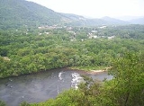
Hot Springs is located at the confluence of the French Broad RiverFrench Broad River
The French Broad River flows from near the village of Rosman in Transylvania County, North Carolina, into the state of Tennessee. Its confluence with the Holston River at Knoxville is the beginning of the Tennessee River....
and Spring Creek
Spring Creek, Madison County, North Carolina
Spring Creek is a tributary stream of the French Broad River in Madison County, North Carolina with a length of approximately 17 miles. It flows in much of its lower course through a section of the Pisgah National Forest and passes the communities of Trust, Luck, and Joe. It joins the French...
. A natural hot spring is also located here, the only such spring known in North Carolina and in much of the southeastern United States. Thus, this area has long since been a destination for those looking for therapeutic relief from their ailments. Native Americans were the first to discover the 100+ degree mineral waters, and European immigrants settled the area over 200 years ago. It is reported that people were visiting the springs by 1778 for the waters' reported healing properties. In 1828, a major road was constructed through the current town, the Buncombe Turnpike, making the area more accessible.
By 1831, James Patton of Asheville bought the springs and had erected 350 room Warm Springs Hotel with its 13 tall columns representing the 13 original colonies in 1837. The dining room of this large hotel could seat 600 people. The railroad reached the village - then called Warm Springs - in 1882. The hotel burned in 1884 after 46 years of operation. Another hotel, called the Mountain Park, was built in 1886. A higher temperature spring was found, prompting the changing of the town's name from Warm Springs to Hot Springs in 1886. Sixteen marble pools were surrounded by landscaped lawns with croquet and tennis courts, and it was known as one of the most lavish resorts in the Southeast. By May 1917, the hotel and grounds were leased to the US Government to be used as an internment camp. That hotel burned in 1920, and two more were built - neither as large and opulent and both later burned as well.
Today, the springs are privately owned as a spa. Water is piped to outdoor tubs beside the river and Spring Creek. The town itself is becoming ever more popular as a modern tourist destination, for aside from the springs, outdoor recreation is abundant in the area. The Appalachian Trail
Appalachian Trail
The Appalachian National Scenic Trail, generally known as the Appalachian Trail or simply the AT, is a marked hiking trail in the eastern United States extending between Springer Mountain in Georgia and Mount Katahdin in Maine. It is approximately long...
runs along downtown's Bridge Street and climbs the mountains on either side of the river. Rafting and kayaking is popular on the French Broad River itself. There are numerous other hiking, mountain biking, backpacking, and sightseeing opportunities in the nearby Pisgah National Forest
Pisgah National Forest
Pisgah National Forest is a National Forest in the Appalachian Mountains of western North Carolina. It is administered by the United States Forest Service, part of the United States Department of Agriculture. The Pisgah National Forest is completely contained within the state of North Carolina...
.
Hot Springs Historic District
Hot Springs Historic DistrictHistoric district
A historic district or heritage district is a section of a city which contains older buildings considered valuable for historical or architectural reasons. In some countries, historic districts receive legal protection from development....
was listed on the National Register of Historic Places
National Register of Historic Places
The National Register of Historic Places is the United States government's official list of districts, sites, buildings, structures, and objects deemed worthy of preservation...
in February 2009.
See also
Hot Springs National ParkHot Springs National Park
Established from Hot Springs Reservation, Hot Springs National Park is a United States National Park in central Arkansas adjacent to the city of Hot Springs. Hot Springs Reservation was initially created by an act of the United States Congress on April 20, 1832, and the area was made a national...
, Hot Springs, Arkansas
Hot Springs, Arkansas
Hot Springs is the 10th most populous city in the U.S. state of Arkansas, the county seat of Garland County, and the principal city of the Hot Springs Metropolitan Statistical Area encompassing all of Garland County...
Source:
- http://www.hotspringsnc.org/history.php