

Blowing Rock, North Carolina
Encyclopedia
Blowing Rock is a town in North Carolina
, USA, situated in both Caldwell
and Watauga
counties. The population was 1,418 at the 2000 census. However, during the summer the town's population increases to about 10,000.]]\\
The Caldwell County portion of Blowing Rock is part of the Hickory
–Lenoir
–Morganton
Metropolitan Statistical Area
, while the Watauga County portion is part of the Boone
Micropolitan Statistical Area.
Blowing Rock is also near Appalachian Ski Mountain
.
The Blowing Rock area was once fought over by the Cherokee
and Catawba
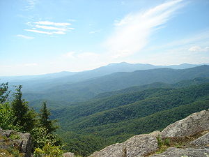
Native American tribes. According to legend, two lovers - one from each tribe - were walking near the rocks when the man received a notice to report to his village and go into battle. When his lover urged him to stay with her, he became so distraught that he threw himself off the blowing rock into the gorge. The woman prayed to the Great Spirit to return her lover, and the Spirit complied by sending a gust of wind which blew the man back up the cliff and landed him safely on the blowing rock itself. This story of course is fictional but it was used as a draw for the attraction. In the 1980s, a billboard in Wilkesboro for Blowing Rock showed two Indians holding hands, one standing on the rock and one "floating". Today "The Blowing Rock" is a tourist attraction and is known for its superb views of the surrounding Blue Ridge Mountains
.
Another tourist attraction in Blowing Rock is the Tweetsie Railroad theme park
, which is home to the only remaining fully functional steam engine train in North Carolina. Visitors to Tweetsie can ride the train for three miles (5 km) and enjoy the mountain scenery; the park also contains traditional amusement-park rides and attractions. Other attractions in the Blowing Rock area include the elegant and historic Green Park Inn, Mystery Hill, the Blowing Rock Country Club, and the Mariam & Robert Hayes Performing Arts Center, which presents music, dance, and films as well as being the home to a professional theatre company (Blowing Rock Stage Company). The Hayes Center suspended operations in September 2009 and has remained closed.
On the nearby Blue Ridge Parkway
is Moses Cone Memorial Park, which offers scenic views of the surrounding mountains. The park contains the Moses Cone Manor and Estate, and features two large lakes surrounded by forests and trails. These trails wind miles, and were once carriage trails for the Cone family. Adjacent to the park is the Blowing Rock Equestrian Preserve, where visitors can board their horses convenient to the trails; there are 25 miles (40.2 km) of riding and carriage trails in the park.
Annual festivals and events in Blowing Rock include: the "Art In The Park" festival, a monthly summertime (May-Oct) event in downtown Blowing Rock where artists set up booths to sell their work to tourists; the Fourth of July festival and parade; Blowing Rock Winterfest in November; the Blue Ridge Wine and Food Festival in April; Christmas in the Park and Lighting of the Town festivities, including a Holiday Parade; the Symphony by the Lake at Chetola Resort; and the Blowing Rock Charity Horse Show which has been a tradition for 84 years. It is the longest continuously run horse show in the United States. The show features some of the best horse riders in the Eastern United States.
 Blowing Rock is located at 36°7′47"N 81°40′21"W (36.129663, -81.672566), in the Blue Ridge
mountain range.
According to the United States Census Bureau
, the town has
Rainfall is moderate; thunderstorms are occasional, and rarely severe.
of 2000, there were 1,418 people, 663 households, and 387 families residing in the town. The population density
was 477.9 people per square mile (184.3/km²). There were 1,524 housing units at an average density of 513.6 per square mile (198.1/km²). The racial makeup of the town was 97.95% White, 0.35% African American, 0.21% Native American, 0.35% Asian, 0.07% from other races
, and 1.06% from two or more races. Hispanic or Latino of any race were 0.63% of the population.
There are 663 households, of which
35.4% of all households were made up of individuals and 14.6% had someone living alone who was 65 years of age or older. The average household size was 2.03 persons and the average family size was 2.59.
The population consists of
The median age is 51 years. For every 100 females there were 86.8 males. For every 100 females age 18 and over, there were 80.4 males.
The median income for a household in the town was $54,271, and the median income for a family was $66,979. Males had a median income of $45,417 compared to $27,361 for females. The per capita income
for the town was $34,294. About 2.9% of families and 9.1% of the population were below the poverty line, including 16.1% of those under age 18 and 6.5% of those age 65 or over.
of the Moravian Church visited The Blowing Rock, the windy cliffs of the area were home to the Cherokee
and the Catawba
Native American tribes.
After the mid-18th century, when hardy Scots-Irish pioneers began to settle in the region, the mountain passes from southern Virginia
into Kentucky
attracted many colonists, farmers, hunters, and trappers who continued south to the mountains of North Carolina. The first family to settle in Blowing Rock were the Greenes, who were established by the mid-19th century on a site that would become the Green Park Hotel property.
Other early settlers in Blowing Rock included the Hayes, Coffey, Bolick, Estes and Storie families. During the American Civil War
the mountains of North Carolina often witnessed fierce guerilla warfare between groups of pro-Confederate and pro-Union fighters. To keep their families safe, men leaving for service in the Confederate Army often sent them to Blowing Rock, which became a local refuge from the fighting.
After the Civil War many of these veterans would join their families and remain in the Blowing Rock area. At the same time, summer residents began to come up from the nearby city of Lenoir
to enjoy the cool fresh air and magnificent mountain views. Seeing the potential of their village to become a haven for well-to-do tourists, the residents of Blowing Rock had their village incorporated into a town on March 11, 1889. The town's first mayor was "Uncle" Joe Clarke, and the town initially had a population of about 300.
As word traveled to other parts of the South about the merits of Blowing Rock, more visitors began to arrive, first camping out, and later taking rooms at boarding houses such as the Hayes and Martin Houses on Main Street. Eventually there were more visitors than the existing boarding houses could handle, and so many homes were turned into hotels. The first hotel
in Blowing Rock was the Watauga Hotel, built in 1884; the hotel added cottages in 1888. The Green Park Hotel opened in 1891, it was followed eight years later by the Blowing Rock Hotel. Walter Alexander, a prominent local resident, touted the clean air and healthy environment of Blowing Rock; in 1922 he opened his own hotel, called Mayview Manor.
As the tourist economy became Blowing Rock's main industry in the late 19th century, the town was forced to adapt to meeting the needs of tourists. The need for cleaner and better streets (most streets then were simply dirt tracks) led to the paving of the town's streets and highways. Another issue involved the need to build fences to keep farm animals from wandering into town and disturbing visitors - at the time most farms in the area were not fenced. In 1896 the town passed an ordinance
which required local farmers to fence in their livestock.
The introduction of the automobile and improved roads early in the 20th century further eased the journey to Blowing Rock, and visitors began to arrive from as far away as Florida. Today Blowing Rock remains a tourist destination for visitors from all over the United States. Due to the town's well-to-do, out-of-state summertime residents, Blowing Rock boasts top-quality restaurants, hotels, golf courses, and other attractions. A recent priority for Blowing Rock's residents has been to preserve and protect the town's historic structures and maintaining the small-town charm and scenery that has attracted so many people for the last 150 years.
itself.
Most services are available in Blowing Rock, in Boone, North Carolina
, approximately eight miles away, or elsewhere in the county. The town is served by U.S. Highways 221 and 321 as well as the Blue Ridge Parkway
. For other transportation facilities, consult Boone, North Carolina
and Watauga County, North Carolina
.
Author Tom Robbins
was born in Blowing Rock in 1936 before moving to Burnsville, NC in 1943. He recounts some early memories of Blowing Rock in Wild Ducks Flying Backward
. Blowing Rock is also home to a group referred to as "The Mormish Council". Blowing Rock is the home of artists of all types, many of whom use the local scenery for their work. Jan Karon
, a native of nearby Lenoir, North Carolina
moved to Blowing Rock in the late 1980s to write fiction. Her bestselling Mitford series of novels is set in a small town based on Blowing Rock; she calls the town "Mitford".
North Carolina
North Carolina is a state located in the southeastern United States. The state borders South Carolina and Georgia to the south, Tennessee to the west and Virginia to the north. North Carolina contains 100 counties. Its capital is Raleigh, and its largest city is Charlotte...
, USA, situated in both Caldwell
Caldwell County, North Carolina
-Demographics:As of the census of 2000, there were 77,415 people, 30,768 households, and 22,399 families residing in the county. The population density was 164 people per square mile . There were 33,430 housing units at an average density of 71 per square mile...
and Watauga
Watauga County, North Carolina
-Demographics:As of the census of 2000, there were 42,695 people, 16,540 households, and 9,411 families residing in the county. The population density was 137 people per square mile . There were 23,155 housing units at an average density of 74 per square mile...
counties. The population was 1,418 at the 2000 census. However, during the summer the town's population increases to about 10,000.]]\\
The Caldwell County portion of Blowing Rock is part of the Hickory
Hickory, North Carolina
Hickory is a city in Catawba County, North Carolina. Hickory has the 162nd largest urban area in the United States. As of the 2000 census, the Metropolitan Statistical Area had a population of 341,851, making it the 4th largest metropolitan area in North Carolina. The city's population was 37,222...
–Lenoir
Lenoir, North Carolina
Lenoir is a city in Caldwell County, North Carolina, United States. The population was 18,228 at the 2010 census. It is the county seat of Caldwell County. Lenoir is located in the Blue Ridge foothills. The city also contains the Brushy Mountains, a spur of the Blue Ridge Mountains...
–Morganton
Morganton, North Carolina
Morganton is a city in Burke County, North Carolina, United States. Reader's Digest included Morganton in its list of top ten places to raise a family. The town was recently profiled in The 50 Best Small Southern Towns. The population was 17,310 at the 2000 census...
Metropolitan Statistical Area
The Unifour
The Hickory-Lenoir-Morganton Metropolitan Statistical Area or The Unifor, as defined by the United States Census Bureau, is an area consisting of four counties in the Catawba Valley region of western North Carolina...
, while the Watauga County portion is part of the Boone
Boone, North Carolina
Boone is a town located in the Blue Ridge Mountains of western North Carolina, United States. Boone's population was reported as 17,122, as of 2010...
Micropolitan Statistical Area.
Attractions
The town of Blowing Rock takes its name from an unusual rock formation which juts over 1500 feet (457.2 m) above the Johns River gorge. Due to the rock's shape and size, wind currents from the gorge often blow vertically, causing light objects to float upwards into the sky.Blowing Rock is also near Appalachian Ski Mountain
Appalachian Ski Mountain
Appalachian Ski Mtn. is one of three ski mountains in the Watauga County area in western North Carolina. It is located off of US 321 between Blowing Rock and Boone, North Carolina.-History:...
.
The Blowing Rock area was once fought over by the Cherokee
Cherokee
The Cherokee are a Native American people historically settled in the Southeastern United States . Linguistically, they are part of the Iroquoian language family...
and Catawba
Catawba
Catawba may refer to several things:*Catawba , a Native American tribe*Catawban languages-Botany:*Catalpa, a genus of trees, based on the name used by the Catawba and other Native American tribes*Catawba , a variety of grape...
Native American tribes. According to legend, two lovers - one from each tribe - were walking near the rocks when the man received a notice to report to his village and go into battle. When his lover urged him to stay with her, he became so distraught that he threw himself off the blowing rock into the gorge. The woman prayed to the Great Spirit to return her lover, and the Spirit complied by sending a gust of wind which blew the man back up the cliff and landed him safely on the blowing rock itself. This story of course is fictional but it was used as a draw for the attraction. In the 1980s, a billboard in Wilkesboro for Blowing Rock showed two Indians holding hands, one standing on the rock and one "floating". Today "The Blowing Rock" is a tourist attraction and is known for its superb views of the surrounding Blue Ridge Mountains
Blue Ridge Mountains
The Blue Ridge Mountains are a physiographic province of the larger Appalachian Mountains range. This province consists of northern and southern physiographic regions, which divide near the Roanoke River gap. The mountain range is located in the eastern United States, starting at its southern-most...
.
Another tourist attraction in Blowing Rock is the Tweetsie Railroad theme park
Tweetsie Railroad
Tweetsie Railroad is a family oriented railroad and Wild West theme park located between Boone and Blowing Rock, North Carolina, United States. In addition to a ride aboard an authentic steam locomotive, the park features amusement rides and other attractions geared towards families with...
, which is home to the only remaining fully functional steam engine train in North Carolina. Visitors to Tweetsie can ride the train for three miles (5 km) and enjoy the mountain scenery; the park also contains traditional amusement-park rides and attractions. Other attractions in the Blowing Rock area include the elegant and historic Green Park Inn, Mystery Hill, the Blowing Rock Country Club, and the Mariam & Robert Hayes Performing Arts Center, which presents music, dance, and films as well as being the home to a professional theatre company (Blowing Rock Stage Company). The Hayes Center suspended operations in September 2009 and has remained closed.
On the nearby Blue Ridge Parkway
Blue Ridge Parkway
The Blue Ridge Parkway is a National Parkway and All-American Road in the United States, noted for its scenic beauty. It runs for 469 miles , mostly along the famous Blue Ridge, a major mountain chain that is part of the Appalachian Mountains...
is Moses Cone Memorial Park, which offers scenic views of the surrounding mountains. The park contains the Moses Cone Manor and Estate, and features two large lakes surrounded by forests and trails. These trails wind miles, and were once carriage trails for the Cone family. Adjacent to the park is the Blowing Rock Equestrian Preserve, where visitors can board their horses convenient to the trails; there are 25 miles (40.2 km) of riding and carriage trails in the park.
Annual festivals and events in Blowing Rock include: the "Art In The Park" festival, a monthly summertime (May-Oct) event in downtown Blowing Rock where artists set up booths to sell their work to tourists; the Fourth of July festival and parade; Blowing Rock Winterfest in November; the Blue Ridge Wine and Food Festival in April; Christmas in the Park and Lighting of the Town festivities, including a Holiday Parade; the Symphony by the Lake at Chetola Resort; and the Blowing Rock Charity Horse Show which has been a tradition for 84 years. It is the longest continuously run horse show in the United States. The show features some of the best horse riders in the Eastern United States.
Geography
Blue Ridge Mountains
The Blue Ridge Mountains are a physiographic province of the larger Appalachian Mountains range. This province consists of northern and southern physiographic regions, which divide near the Roanoke River gap. The mountain range is located in the eastern United States, starting at its southern-most...
mountain range.
According to the United States Census Bureau
United States Census Bureau
The United States Census Bureau is the government agency that is responsible for the United States Census. It also gathers other national demographic and economic data...
, the town has
- a total area of 3.0 square miles (7.8 km²).
- 3.0 square miles (7.7 km²) of it is land and
- 0.04 square miles (0.1 km²), or 1.00% of total area, is water.
Climate
The town's elevation of 3500 to 3600 feet (1067–1097 meters) above sea level results in cooler summer temperatures than lowland areas to the east and south. Daytime temperatures in the summer rarely rise above 80 degrees fahrenheit (27 degrees Celsius). However, temperatures in the winter are much colder and harsher than would be expected in a southern state. Daytime highs can frequently fall into the 20s or lower. Snow, sleet, and freezing rain are all common in the winter months. Springtime in Blowing Rock is cool and generally pleasant.Rainfall is moderate; thunderstorms are occasional, and rarely severe.
Demographics
As of the censusCensus
A census is the procedure of systematically acquiring and recording information about the members of a given population. It is a regularly occurring and official count of a particular population. The term is used mostly in connection with national population and housing censuses; other common...
of 2000, there were 1,418 people, 663 households, and 387 families residing in the town. The population density
Population density
Population density is a measurement of population per unit area or unit volume. It is frequently applied to living organisms, and particularly to humans...
was 477.9 people per square mile (184.3/km²). There were 1,524 housing units at an average density of 513.6 per square mile (198.1/km²). The racial makeup of the town was 97.95% White, 0.35% African American, 0.21% Native American, 0.35% Asian, 0.07% from other races
Race (United States Census)
Race and ethnicity in the United States Census, as defined by the Federal Office of Management and Budget and the United States Census Bureau, are self-identification data items in which residents choose the race or races with which they most closely identify, and indicate whether or not they are...
, and 1.06% from two or more races. Hispanic or Latino of any race were 0.63% of the population.
There are 663 households, of which
- 16.9% have children under the age of 18 living with them,
- 52.3% were married couples living together,
- 4.5% had a female householder with no husband present, and
- 41.5% were non-families.
35.4% of all households were made up of individuals and 14.6% had someone living alone who was 65 years of age or older. The average household size was 2.03 persons and the average family size was 2.59.
The population consists of
- 15.0% under the age of 18,
- 4.9% from 18 to 24,
- 20.0% from 25 to 44,
- 34.1% from 45 to 64, and
- 26.0% 65 years or older.
The median age is 51 years. For every 100 females there were 86.8 males. For every 100 females age 18 and over, there were 80.4 males.
The median income for a household in the town was $54,271, and the median income for a family was $66,979. Males had a median income of $45,417 compared to $27,361 for females. The per capita income
Per capita income
Per capita income or income per person is a measure of mean income within an economic aggregate, such as a country or city. It is calculated by taking a measure of all sources of income in the aggregate and dividing it by the total population...
for the town was $34,294. About 2.9% of families and 9.1% of the population were below the poverty line, including 16.1% of those under age 18 and 6.5% of those age 65 or over.
History
Before 1752, when Bishop August Gottlieb SpangenbergAugust Gottlieb Spangenberg
August Gottlieb Spangenberg was a German theologian and minister, and a bishop of the Moravian Brethren. As successor of Count Nicolaus Ludwig Zinzendorf, he helped develop international missions, as well as stabilize the theology and organization of the German Moravian Church.-Early life and...
of the Moravian Church visited The Blowing Rock, the windy cliffs of the area were home to the Cherokee
Cherokee
The Cherokee are a Native American people historically settled in the Southeastern United States . Linguistically, they are part of the Iroquoian language family...
and the Catawba
Catawba
Catawba may refer to several things:*Catawba , a Native American tribe*Catawban languages-Botany:*Catalpa, a genus of trees, based on the name used by the Catawba and other Native American tribes*Catawba , a variety of grape...
Native American tribes.
After the mid-18th century, when hardy Scots-Irish pioneers began to settle in the region, the mountain passes from southern Virginia
Virginia
The Commonwealth of Virginia , is a U.S. state on the Atlantic Coast of the Southern United States. Virginia is nicknamed the "Old Dominion" and sometimes the "Mother of Presidents" after the eight U.S. presidents born there...
into Kentucky
Kentucky
The Commonwealth of Kentucky is a state located in the East Central United States of America. As classified by the United States Census Bureau, Kentucky is a Southern state, more specifically in the East South Central region. Kentucky is one of four U.S. states constituted as a commonwealth...
attracted many colonists, farmers, hunters, and trappers who continued south to the mountains of North Carolina. The first family to settle in Blowing Rock were the Greenes, who were established by the mid-19th century on a site that would become the Green Park Hotel property.
Other early settlers in Blowing Rock included the Hayes, Coffey, Bolick, Estes and Storie families. During the American Civil War
American Civil War
The American Civil War was a civil war fought in the United States of America. In response to the election of Abraham Lincoln as President of the United States, 11 southern slave states declared their secession from the United States and formed the Confederate States of America ; the other 25...
the mountains of North Carolina often witnessed fierce guerilla warfare between groups of pro-Confederate and pro-Union fighters. To keep their families safe, men leaving for service in the Confederate Army often sent them to Blowing Rock, which became a local refuge from the fighting.
After the Civil War many of these veterans would join their families and remain in the Blowing Rock area. At the same time, summer residents began to come up from the nearby city of Lenoir
Lenoir, North Carolina
Lenoir is a city in Caldwell County, North Carolina, United States. The population was 18,228 at the 2010 census. It is the county seat of Caldwell County. Lenoir is located in the Blue Ridge foothills. The city also contains the Brushy Mountains, a spur of the Blue Ridge Mountains...
to enjoy the cool fresh air and magnificent mountain views. Seeing the potential of their village to become a haven for well-to-do tourists, the residents of Blowing Rock had their village incorporated into a town on March 11, 1889. The town's first mayor was "Uncle" Joe Clarke, and the town initially had a population of about 300.
As word traveled to other parts of the South about the merits of Blowing Rock, more visitors began to arrive, first camping out, and later taking rooms at boarding houses such as the Hayes and Martin Houses on Main Street. Eventually there were more visitors than the existing boarding houses could handle, and so many homes were turned into hotels. The first hotel
Hotel
A hotel is an establishment that provides paid lodging on a short-term basis. The provision of basic accommodation, in times past, consisting only of a room with a bed, a cupboard, a small table and a washstand has largely been replaced by rooms with modern facilities, including en-suite bathrooms...
in Blowing Rock was the Watauga Hotel, built in 1884; the hotel added cottages in 1888. The Green Park Hotel opened in 1891, it was followed eight years later by the Blowing Rock Hotel. Walter Alexander, a prominent local resident, touted the clean air and healthy environment of Blowing Rock; in 1922 he opened his own hotel, called Mayview Manor.
As the tourist economy became Blowing Rock's main industry in the late 19th century, the town was forced to adapt to meeting the needs of tourists. The need for cleaner and better streets (most streets then were simply dirt tracks) led to the paving of the town's streets and highways. Another issue involved the need to build fences to keep farm animals from wandering into town and disturbing visitors - at the time most farms in the area were not fenced. In 1896 the town passed an ordinance
Local ordinance
A local ordinance is a law usually found in a municipal code.-United States:In the United States, these laws are enforced locally in addition to state law and federal law.-Japan:...
which required local farmers to fence in their livestock.
The introduction of the automobile and improved roads early in the 20th century further eased the journey to Blowing Rock, and visitors began to arrive from as far away as Florida. Today Blowing Rock remains a tourist destination for visitors from all over the United States. Due to the town's well-to-do, out-of-state summertime residents, Blowing Rock boasts top-quality restaurants, hotels, golf courses, and other attractions. A recent priority for Blowing Rock's residents has been to preserve and protect the town's historic structures and maintaining the small-town charm and scenery that has attracted so many people for the last 150 years.
Miscellaneous
The town has a vibrant economy based in part on tourism. A small, quaint, downtown area is characterized by shops, a public park, and restaurants. The mountainous terrain provides scenic views with long-range vistas from several locations around town, including the Blowing RockBlowing Rock (land feature)
Blowing Rock is a rocky outcropping at the town of Blowing Rock, North Carolina, above a gorge in Caldwell County, in the northwest of that state.The prevailing wind blows through the gorge toward Blowing Rock...
itself.
Most services are available in Blowing Rock, in Boone, North Carolina
Boone, North Carolina
Boone is a town located in the Blue Ridge Mountains of western North Carolina, United States. Boone's population was reported as 17,122, as of 2010...
, approximately eight miles away, or elsewhere in the county. The town is served by U.S. Highways 221 and 321 as well as the Blue Ridge Parkway
Blue Ridge Parkway
The Blue Ridge Parkway is a National Parkway and All-American Road in the United States, noted for its scenic beauty. It runs for 469 miles , mostly along the famous Blue Ridge, a major mountain chain that is part of the Appalachian Mountains...
. For other transportation facilities, consult Boone, North Carolina
Boone, North Carolina
Boone is a town located in the Blue Ridge Mountains of western North Carolina, United States. Boone's population was reported as 17,122, as of 2010...
and Watauga County, North Carolina
Watauga County, North Carolina
-Demographics:As of the census of 2000, there were 42,695 people, 16,540 households, and 9,411 families residing in the county. The population density was 137 people per square mile . There were 23,155 housing units at an average density of 74 per square mile...
.
Author Tom Robbins
Tom Robbins
Thomas Eugene "Tom" Robbins Thomas Eugene "Tom" Robbins Thomas Eugene "Tom" Robbins (born July 22, 1936 is an American author. His best-selling novels are serio-comic, often wildly poetic stories with a strong social and philosophical undercurrent, an irreverent bent, and scenes extrapolated from...
was born in Blowing Rock in 1936 before moving to Burnsville, NC in 1943. He recounts some early memories of Blowing Rock in Wild Ducks Flying Backward
Wild Ducks Flying Backward
Wild Ducks Flying Backward is Tom Robbins' book, published on August 30, 2005. It is an anthology of poems, short stories, essays, reviews, and other brief writings over Robbins' career....
. Blowing Rock is also home to a group referred to as "The Mormish Council". Blowing Rock is the home of artists of all types, many of whom use the local scenery for their work. Jan Karon
Jan Karon
Jan Karon is an American writer and novelist, who has written for both children and adults. Karon was born in Lenoir, North Carolina, in 1937, as Janice Meredith Wilson. She retired from a career in advertising and moved to Blowing Rock, North Carolina, to write...
, a native of nearby Lenoir, North Carolina
Lenoir, North Carolina
Lenoir is a city in Caldwell County, North Carolina, United States. The population was 18,228 at the 2010 census. It is the county seat of Caldwell County. Lenoir is located in the Blue Ridge foothills. The city also contains the Brushy Mountains, a spur of the Blue Ridge Mountains...
moved to Blowing Rock in the late 1980s to write fiction. Her bestselling Mitford series of novels is set in a small town based on Blowing Rock; she calls the town "Mitford".