
Jackson County, North Carolina
Encyclopedia
Jackson County is a county located in the southwest of the U.S. state
of North Carolina
. As of 2010, the population
was 40,271. Since 1913 its county seat
has been Sylva
, replacing Webster
.
and Macon County
. It was named for Andrew Jackson
, President of the United States
from 1829 to 1837. The original county courts were held at the Dan Bryson home in the community of Beta in Scott Creek township, and moved to Webster the following year.
In 1861 parts of Jackson County and Henderson County
were combined to form Transylvania County
. In 1871 parts of Jackson County and Macon County
were combined to form Swain County
. In 1913 Sylva
became the county seat.
council of governments.
Jackson County contains a portion of the Qualla Boundary
, a tribal reservation for the Eastern Band of Cherokee Indians
, which is subject mostly to tribal/federal laws rather than county or state laws.
, the county has a total area of 494 square miles (1,279.5 km²), of which 491 square miles (1,271.7 km²) is land and 4 square miles (10.4 km²) (0.77%) is water.
:
Barker's Creek: Named for the creek which originates and flows through the township before entering the Tuckasegee River. It includes the Dicks Creek, Barkers Creek, and Wilmont communities, and US 74/23 runs as a four-lane divided highway
through the township. It is served by Smokey Mountain Elementary School and Smoky Mountain High School
. Formerly, the Log Cabin Association Consolidated School served the township, but it closed when Smokey Mountain Elementary opened in 1980.
Canada: Named for the tall ridge
s, narrow valley
s, and sharp peaks
of this part of the county, the main waterway is the East Fork of the Tuckasegee River which flows into the River Township before joining the West Fork, becoming the Tuckasegee River. There are four major lakes, Bear, Wolf, Tanasee Creek, and Ceader Cliff, in the township. It is served by NC 281 and is one of the most remote locations in the county. It is served by Cullowhee Valley School and Smoky Mountain High School. Before the 1990s, the schools for the area were Canada Consolidated School and Cullowhee High School, both closed in the 1980s.
Caney Fork: Named for the creek that flows through the township, Caney Fork, which empties into the Tuckasegee River at East LaPorte. The main road is Caney Fork Road, and the area is served by Cullowhee Valley School and Smoky Mountain High School. Prior to 1964 the schools that served the area were Johns Creek Elementary and Cullowhee High School.
Cashiers: Named for a lost horse, the town of Cashiers
is located here, as well as the communities of Panthertown Valley, Whiteside Cove, Fairfield, and Sapphire. It is served by NC 107 and US 64. The Eastern Continental Divide
follows a ridge north of the township, and defines the boundaries between the Cashiers, Canada, and Glenville townships. The Chattooga
, Horsepasture
, and Toxaway
rivers all originate or flow through the township. It is served by Blue Ridge School
, which consolidated Glenville School and Cashiers Elementary in 1975.
Cullowhee: The Cherokee
name for the valley was corrupted from its original name into Cullowhee
, the original meaning either "Valley of the Lilies" or "Valley of the Buzzards." The valley of the lilies nickname is more commonly referred to. NC 107, Old NC 107, and NC 107-Alternate all serve the township as major roads, though NC 107 is the only 4-lane roadway. Western Carolina University
, the village of Forest Hills
, and the communities of Speedwell, Old Cullowhee Road, Buzzards Roost, and Dicks Gap are all within the township. It was one of the first areas in the county to be settled by the whites, along with Caney Fork, River, Scott Creek, and Canada townships. It is the largest township population-wise according to the 2000 United States Census. The Tuckasegee River and Cullowhee Creek both flow through the township, with the latter emptying into the former around Old Cullowhee Road. It is served by Cullowhee Valley School, located in the township, and Smoky Mountain High School
in Sylva
. Formerly, there was Cullowhee High School, but it closed in 1988.
Dillsboro: Named after the Dills Family who founded the town, the township is home to the town of Dillsboro
. To the northwest of Dillsboro, Scotts Creek, which flows from Scott Creek Township through Sylva Township into Dillsboro Township, empties into the Tuckasegee River. US 74/23, US 441, and NC 107 all converge in two major intersections within the township. The township is served by Smokey Mountain and Fairview elementary schools and by Smoky Mountain High School
. It hasn't had its own school since Dillsboro Elementary closed in 1951. The students were then transferred to Log Cabin School in Barkers Creek Township or Sylva Elementary School in Sylva
township.
Greens Creek: Named for the creek which flows through most of the township before emptying into Savannah Creek, Greens Creek Township is served by US 441, in the form of a four-lane highway along the western edge. Greens Creek Road goes through the middle of the township. It is served by Fairview Elementary School and Smokey Mountain Elementary School, as well as Smoky Mountain High School. It was formerly served by the Savannah Consolidated School, which opened in 1940 and closed in 1973.
Hamburg: Named for the fort and original name of Glenville
, the township is served by NC 107. The area was once a large valley, but the valley was flooded in 1941 to form Lake Glenville
. The West Fork of the Tuckasegee River originates within the township, and flows north into the River Township. Blue Ridge School
is located in the township and serves the township. It originated from the consolidation of the Glenville School and Cashiers Elementary School in 1975.
Mountain: Named for Cullowhee Mountain which it resides on, the Mountain Township is served by NC 107 Alternate. The headwaters of Cullowhee Creek are located here, flowing north into Cullowhee
Township before joining the Tuckasegee River. It is served by Cullowhee Valley School/Smoky Mountain High School, and was formerly served by Cullowhee High School and Camp Lab Elementary.
Qualla: Named for the Qualla Boundary
which takes up a lion's share portion of the township, Qualla Township is served by US 441, US 19, and US 74/23. Smokey Mountain Elementary School is located in the township, resulting from the 1980 consolidation of Qualla Elementary School and Log Cabin Association Consolidated School. It is served by the Jackson County Public School System
and the Cherokee Reservation School System. Students can choose to either go to Smokey Mountain Elementary/Smoky Mountain High School
, Cherokee School
, or Swain East Elementary, Swain Middle School and Swain High School. The communities of Qualla, Birdtown, Soco, Whittier
, Indian Hills, and Wilmont are all located at least partially, if not wholly, within the township.
River: Named for the Tuckasegee River, which converges from two streams into one within the township, it is served by NC 107 and NC 281. The community of Tuckasegee
is located in the township. It is served by Cullowhee Valley School/Smoky Mountain High School
, and, prior to 1958, Tuckasegee School and Cullowhee High School.
Savannah: Named for Savannah Creek, which runs through the district, Savannah Township is home to the Viewpoint, Pumpkintown, Savannah, and Fort Wilderness communities. The township is served by four-lane US 441. Fairview Elementary School and Smoky Mountain High School serve the township as well. It was home to Savannah Consolidated School, which fed into Webster High School
and later Sylva-Webster High School
, from 1940 until 1973.
Scotts Creek: Named for Scotts Creek, which begins and flows through the township before running into Sylva Township. It is served by US 74/23 and old US 19/23, which run through the five communities within the township, Balsam
, Willets, Ochre Hill, Addie, and Beta. The Murphy Branch Railroad also runs through the township. Scotts Creek School has served the township since 1951, and had a new building constructed in 2001.
Sylva: Named for William D. Sylva, as is the town of Sylva
, located within the township, which is served by NC 107, US 74/23, and BUS 23. The Jackson County Courthouse and Library are both located in the township. Scotts Creek runs through the township before emptying into Dillsboro
Township. The township is served by Fairview and Scotts Creek elementary schools and Smoky Mountain High School
. Formerly, students in the township would have gone to Sylva Elementary/Sylva High School, and later Sylva-Webster High School
, but consolidation has closed many smaller schools in the county.
Webster: The location of the town of Webster
, Webster Township sits at the original geographical center
of the county, which has moved to Cullowhee
Township due to land taken away for the formation of Swain
and Transylvania
counties. It was for many years home to the only town in Jackson County. It is served by NC 116 and NC 107. The county seat
designation and courthouse
were located here from 1851 to 1913, but the county seat subsequently moved to Sylva
. The township once was home to Webster Elementary School
(1936–1973) and Webster High School
(1936–1960), but now the schools that serve the township are Fairview Elementary School (1973) and Smoky Mountain High School
(1960/1988).
(map)
of 2010, there were 40,271 people. As of the 2000 Census, there were 13,191 households and 8,587 families residing in the county. The population density
was 68 people per square mile (26/km²). There were 19,291 housing units at an average density of 39 per square mile (15/km²). The racial makeup of the county was 85.68% White
, 1.67% Black
or African American
, 10.20% Native American
, 0.51% Asian
, 0.02% Pacific Islander
, 0.55% from other races
, and 1.38% from two or more races. 1.74% of the population were Hispanic
or Latino
of any race. 18.5% were of American, 13.7% English
, 11.3% Irish
, 10.5% German and 9.2% Scots-Irish ancestry according to Census 2000. 95.3% spoke English, 2.1% Spanish and 1.5% Cherokee
as their first language.
There were 13,191 households out of which 25.50% had children under the age of 18 living with them, 51.40% were married couples
living together, 10.00% had a female householder with no husband present, and 34.90% were non-families. 27.00% of all households were made up of individuals and 9.80% had someone living alone who was 65 years of age or older. The average household size was 2.30 and the average family size was 2.79.
In the county the population was spread out with 19.00% under the age of 18, 17.90% from 18 to 24, 24.40% from 25 to 44, 25.00% from 45 to 64, and 13.80% who were 65 years of age or older. The median age was 36 years. For every 100 females there were 95.40 males. For every 100 females age 18 and over, there were 93.10 males.
The median income for a household in the county was $32,552, and the median income for a family was $40,876. Males had a median income of $27,738 versus $22,029 for females. The per capita income
for the county was $17,582. About 9.50% of families and 15.10% of the population were below the poverty line, including 15.70% of those under age 18 and 15.20% of those age 65 or over.
runs east-west across the northern half of the county and connects the county seat of Sylva
to Waynesville
and Asheville
in the east and Cherokee
, Andrews
and Murphy
in the west. North Carolina State Highway 107
connects Sylva and Western Carolina University
to Cashiers
in the south. U.S. Highway 64 traverses east-west across the southern part of the county connecting Cashiers to Brevard
in the east and Highlands
in the west.
operates a portion the Murphy Branch
through Jackson County, providing a rail connection with the rest of the country. In Sylva
, Norfolk Southern connects with the Great Smoky Mountains Railroad
. Interchange between the two lines is handled near Jackson Paper Company. Great Smoky Mountains Railroad
operates the rest of the Murphy Branch from Dillsboro
to Andrews
.
located one mile (1.6 km) east of Cullowhee.
Grace Community Church is a new church with casual, contemporary worship that meets at the Sylva Inn. Rich Peoples is the church's pastor.
Dick's Creek is a road and community just west of Dillsboro off of Highway 74 in Jackson County. Just over 1.5 miles (2.4 km) up the road on the right is historic Dick's Creek Baptist Church built in 1903. Until 1946 this church was used as both a church and school. As of 2009, services are still held.
LifeWay Community Church is located in the heart of downtown Sylva. A non-denominational church, LifeWay meets weekly on Sunday mornings at their main campus and has small group meetings on Wednesday evenings throughout Jackson and Swain counties.
starring Harrison Ford
and Tommy Lee Jones
, the 1972 drama Deliverance
, and the 1996 comedy My Fellow Americans
starring Jack Lemmon
and James Garner
.
U.S. state
A U.S. state is any one of the 50 federated states of the United States of America that share sovereignty with the federal government. Because of this shared sovereignty, an American is a citizen both of the federal entity and of his or her state of domicile. Four states use the official title of...
of North Carolina
North Carolina
North Carolina is a state located in the southeastern United States. The state borders South Carolina and Georgia to the south, Tennessee to the west and Virginia to the north. North Carolina contains 100 counties. Its capital is Raleigh, and its largest city is Charlotte...
. As of 2010, the population
Population
A population is all the organisms that both belong to the same group or species and live in the same geographical area. The area that is used to define a sexual population is such that inter-breeding is possible between any pair within the area and more probable than cross-breeding with individuals...
was 40,271. Since 1913 its county seat
County seat
A county seat is an administrative center, or seat of government, for a county or civil parish. The term is primarily used in the United States....
has been Sylva
Sylva, North Carolina
Sylva is an incorporated town located in central Jackson County, in the Great Smoky Mountains of Western North Carolina, United States of America. As of the 2010 census, the town had a total population of 2,588. It is the county seat, having taken over from nearby Webster in 1913.-Geography:Sylva...
, replacing Webster
Webster, North Carolina
Webster is a town in Jackson County, North Carolina, United States. As of the 2010 census, the population was 363.Webster was the first county seat of Jackson county, until Sylva took over in 1913.-Geography:Webster is located at ....
.
History
The county was formed in 1851 from parts of Haywood CountyHaywood County, North Carolina
-National protected areas:* Blue Ridge Parkway * Great Smoky Mountains National Park * Pisgah National Forest -Major Highways & Roads:* Interstate 40* U.S. Highway 19* U.S. Highway 23* U.S. Highway 74* U.S...
and Macon County
Macon County, North Carolina
- Geographic features :Of the in Macon County, are federal lands that lie within the Nantahala National Forest and are administered by the United States Forest Service. Of the of USFS land, lie in the Highlands Ranger District and the remaining lie in the Wayah Ranger District...
. It was named for Andrew Jackson
Andrew Jackson
Andrew Jackson was the seventh President of the United States . Based in frontier Tennessee, Jackson was a politician and army general who defeated the Creek Indians at the Battle of Horseshoe Bend , and the British at the Battle of New Orleans...
, President of the United States
President of the United States
The President of the United States of America is the head of state and head of government of the United States. The president leads the executive branch of the federal government and is the commander-in-chief of the United States Armed Forces....
from 1829 to 1837. The original county courts were held at the Dan Bryson home in the community of Beta in Scott Creek township, and moved to Webster the following year.
In 1861 parts of Jackson County and Henderson County
Henderson County, North Carolina
Henderson County is a county located in the U.S. state of North Carolina. It is part of the Asheville, North Carolina, Metropolitan Statistical Area. As of 2008, the population was 102,367. Its county seat is Hendersonville.- History :...
were combined to form Transylvania County
Transylvania County, North Carolina
Transylvania County is a county located in the U.S. state of North Carolina. As of 2010, the population was 33,090. Its county seat is Brevard.- History :The county was formed in 1861 from parts of Henderson County and Jackson County...
. In 1871 parts of Jackson County and Macon County
Macon County, North Carolina
- Geographic features :Of the in Macon County, are federal lands that lie within the Nantahala National Forest and are administered by the United States Forest Service. Of the of USFS land, lie in the Highlands Ranger District and the remaining lie in the Wayah Ranger District...
were combined to form Swain County
Swain County, North Carolina
Swain County is a county located in the U.S. state of North Carolina. As of 2000, the population was 12,968. Its county seat is Bryson City.Swain County is home of the Nantahala River . The Nantahala is one of the most popular whitewater rafting rivers in the nation...
. In 1913 Sylva
Sylva, North Carolina
Sylva is an incorporated town located in central Jackson County, in the Great Smoky Mountains of Western North Carolina, United States of America. As of the 2010 census, the town had a total population of 2,588. It is the county seat, having taken over from nearby Webster in 1913.-Geography:Sylva...
became the county seat.
Law and government
Jackson County is a member of the regional Southwestern CommissionSouthwestern Commission
The Southwestern North Carolina Planning and Economic Development Commission, also known as the Southwestern Commission, is one of the 17 regional North Carolina Councils of Government...
council of governments.
Jackson County contains a portion of the Qualla Boundary
Qualla Boundary
The Qualla Boundary is the territory where the Eastern Band of Cherokee Indians reside in western North Carolina.-Location:...
, a tribal reservation for the Eastern Band of Cherokee Indians
Eastern Band of Cherokee Indians
The Eastern Band of Cherokee Indians , is a federally recognized Native American tribe in the United States of America, who are descended from Cherokee who remained in the Eastern United States while others moved, or were forced to relocate, to the west in the 19th century. The history of the...
, which is subject mostly to tribal/federal laws rather than county or state laws.
Geography
According to the U.S. Census BureauUnited States Census Bureau
The United States Census Bureau is the government agency that is responsible for the United States Census. It also gathers other national demographic and economic data...
, the county has a total area of 494 square miles (1,279.5 km²), of which 491 square miles (1,271.7 km²) is land and 4 square miles (10.4 km²) (0.77%) is water.
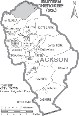
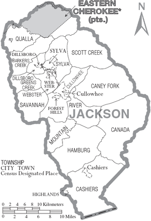
Townships
The county is divided into fifteen townshipsTownship (United States)
A township in the United States is a small geographic area. Townships range in size from 6 to 54 square miles , with being the norm.The term is used in three ways....
:
Barker's Creek: Named for the creek which originates and flows through the township before entering the Tuckasegee River. It includes the Dicks Creek, Barkers Creek, and Wilmont communities, and US 74/23 runs as a four-lane divided highway
Divided Highway
Divided Highway is a compilation album by American rock band The Doobie Brothers, released in 2003. . All tracks are taken from the albums Cycles and Brotherhood .-Track listing:...
through the township. It is served by Smokey Mountain Elementary School and Smoky Mountain High School
Smoky Mountain High School
Smoky Mountain High School is a public high school located in Sylva, North Carolina. The school formed as a result of the consolidation of the former Sylva-Webster High School and Cullowhee High School in 1988, at the Sylva-Webster Campus, which dates to 1960....
. Formerly, the Log Cabin Association Consolidated School served the township, but it closed when Smokey Mountain Elementary opened in 1980.
Canada: Named for the tall ridge
Ridge
A ridge is a geological feature consisting of a chain of mountains or hills that form a continuous elevated crest for some distance. Ridges are usually termed hills or mountains as well, depending on size. There are several main types of ridges:...
s, narrow valley
Valley
In geology, a valley or dale is a depression with predominant extent in one direction. A very deep river valley may be called a canyon or gorge.The terms U-shaped and V-shaped are descriptive terms of geography to characterize the form of valleys...
s, and sharp peaks
Mountain peak
A mountain peak is the highest part of a mountain; a mountaintop; the summit.Mountain Peak may also refer to:* Blue Mountain Peak, Jamaica* Hole in the Mountain Peak, Nevada, USA...
of this part of the county, the main waterway is the East Fork of the Tuckasegee River which flows into the River Township before joining the West Fork, becoming the Tuckasegee River. There are four major lakes, Bear, Wolf, Tanasee Creek, and Ceader Cliff, in the township. It is served by NC 281 and is one of the most remote locations in the county. It is served by Cullowhee Valley School and Smoky Mountain High School. Before the 1990s, the schools for the area were Canada Consolidated School and Cullowhee High School, both closed in the 1980s.
Caney Fork: Named for the creek that flows through the township, Caney Fork, which empties into the Tuckasegee River at East LaPorte. The main road is Caney Fork Road, and the area is served by Cullowhee Valley School and Smoky Mountain High School. Prior to 1964 the schools that served the area were Johns Creek Elementary and Cullowhee High School.
Cashiers: Named for a lost horse, the town of Cashiers
Cashiers, North Carolina
Cashiers is a census-designated place and unincorporated village located in southern Jackson County, North Carolina. As of the 2010 census, the community had a total population of 157. During the summer season , the population swells to 20,000...
is located here, as well as the communities of Panthertown Valley, Whiteside Cove, Fairfield, and Sapphire. It is served by NC 107 and US 64. The Eastern Continental Divide
Eastern Continental Divide
The Eastern Continental Divide, in conjunction with other continental divides of North America, demarcates two watersheds of the Atlantic Ocean: the Gulf of Mexico watershed and the Atlantic Seaboard watershed. Prior to 1760, the divide represented the boundary between British and French colonial...
follows a ridge north of the township, and defines the boundaries between the Cashiers, Canada, and Glenville townships. The Chattooga
Chattooga River
The Chattooga River is the main tributary of the Tugaloo River. Its headwaters are located southwest of Cashiers, North Carolina, and it stretches to where it has its confluence with the Tallulah River within Lake Tugalo, held back by the Tugalo Dam...
, Horsepasture
Horsepasture River
The Horsepasture River is an National Wild and Scenic river in the U.S. states of North Carolina and South Carolina. The river rises in Jackson County, North Carolina, and flows through the Jocassee Gorges area and ends at Lake Jocassee in South Carolina...
, and Toxaway
Toxaway River
The Toxaway River is a waterway that flows south from headwaters in Transylvania County, North Carolina, into Lake Toxaway and over Toxaway Falls, after which it crosses into South Carolina and enters Lake Jocassee, the reservoir behind Lake Jocassee Dam....
rivers all originate or flow through the township. It is served by Blue Ridge School
Blue Ridge School (Cashiers, North Carolina)
Blue Ridge School is a public combined Elementary, Middle, and High School located in Cashiers, North Carolina and is part of the Jackson County Public Schools System. It is the smallest school in the district and resulted from the consolidation of the larger Glenville Elementary and High School...
, which consolidated Glenville School and Cashiers Elementary in 1975.
Cullowhee: The Cherokee
Cherokee
The Cherokee are a Native American people historically settled in the Southeastern United States . Linguistically, they are part of the Iroquoian language family...
name for the valley was corrupted from its original name into Cullowhee
Cullowhee, North Carolina
Cullowhee is a census-designated place in Jackson County, North Carolina, United States. Cullowhee is best known for being the home of Western Carolina University . The population was 9,428 as of the 2010 census. The area known as Cullowhee has Western Carolina University, part of the UNC...
, the original meaning either "Valley of the Lilies" or "Valley of the Buzzards." The valley of the lilies nickname is more commonly referred to. NC 107, Old NC 107, and NC 107-Alternate all serve the township as major roads, though NC 107 is the only 4-lane roadway. Western Carolina University
Western Carolina University
Western Carolina University is a coeducational public university located in Cullowhee, North Carolina, United States. The university is a constituent campus of the University of North Carolina system....
, the village of Forest Hills
Forest Hills, North Carolina
Forest Hills is a village in Jackson County, North Carolina, United States. The population was 365 at the 2010 census. Formerly a neighborhood within nearby unincorporated Cullowhee, it became incorporated in 1997...
, and the communities of Speedwell, Old Cullowhee Road, Buzzards Roost, and Dicks Gap are all within the township. It was one of the first areas in the county to be settled by the whites, along with Caney Fork, River, Scott Creek, and Canada townships. It is the largest township population-wise according to the 2000 United States Census. The Tuckasegee River and Cullowhee Creek both flow through the township, with the latter emptying into the former around Old Cullowhee Road. It is served by Cullowhee Valley School, located in the township, and Smoky Mountain High School
Smoky Mountain High School
Smoky Mountain High School is a public high school located in Sylva, North Carolina. The school formed as a result of the consolidation of the former Sylva-Webster High School and Cullowhee High School in 1988, at the Sylva-Webster Campus, which dates to 1960....
in Sylva
Sylva, North Carolina
Sylva is an incorporated town located in central Jackson County, in the Great Smoky Mountains of Western North Carolina, United States of America. As of the 2010 census, the town had a total population of 2,588. It is the county seat, having taken over from nearby Webster in 1913.-Geography:Sylva...
. Formerly, there was Cullowhee High School, but it closed in 1988.
Dillsboro: Named after the Dills Family who founded the town, the township is home to the town of Dillsboro
Dillsboro, North Carolina
Dillsboro is a town in Jackson County, North Carolina, United States. The town is a popular tourist location, at which visitors tend to stop on their way into the Great Smoky Mountains. The town of Sylva is located just one mile east of Dillsboro and is the county seat...
. To the northwest of Dillsboro, Scotts Creek, which flows from Scott Creek Township through Sylva Township into Dillsboro Township, empties into the Tuckasegee River. US 74/23, US 441, and NC 107 all converge in two major intersections within the township. The township is served by Smokey Mountain and Fairview elementary schools and by Smoky Mountain High School
Smoky Mountain High School
Smoky Mountain High School is a public high school located in Sylva, North Carolina. The school formed as a result of the consolidation of the former Sylva-Webster High School and Cullowhee High School in 1988, at the Sylva-Webster Campus, which dates to 1960....
. It hasn't had its own school since Dillsboro Elementary closed in 1951. The students were then transferred to Log Cabin School in Barkers Creek Township or Sylva Elementary School in Sylva
Sylva, North Carolina
Sylva is an incorporated town located in central Jackson County, in the Great Smoky Mountains of Western North Carolina, United States of America. As of the 2010 census, the town had a total population of 2,588. It is the county seat, having taken over from nearby Webster in 1913.-Geography:Sylva...
township.
Greens Creek: Named for the creek which flows through most of the township before emptying into Savannah Creek, Greens Creek Township is served by US 441, in the form of a four-lane highway along the western edge. Greens Creek Road goes through the middle of the township. It is served by Fairview Elementary School and Smokey Mountain Elementary School, as well as Smoky Mountain High School. It was formerly served by the Savannah Consolidated School, which opened in 1940 and closed in 1973.
Hamburg: Named for the fort and original name of Glenville
Glenville, North Carolina
Glenville was a town located in the Hamburg township of Jackson County, North Carolina. It is now a popular lakeside vacation community with many second homes that sometimes are rented around Lake Glenville, which flooded and destroyed the town.-History:...
, the township is served by NC 107. The area was once a large valley, but the valley was flooded in 1941 to form Lake Glenville
Lake Glenville
Lake Glenville is a reservoir located just 8 miles from Cashiers, North Carolina. It was formed by the damming of the west fork of the Tuckasegee River in 1941. Between 1951 and 2002, it was officially known as "Thorpe Reservoir" after J. E. S. Thorpe, Nantahala Power's first president. It is still...
. The West Fork of the Tuckasegee River originates within the township, and flows north into the River Township. Blue Ridge School
Blue Ridge School (Cashiers, North Carolina)
Blue Ridge School is a public combined Elementary, Middle, and High School located in Cashiers, North Carolina and is part of the Jackson County Public Schools System. It is the smallest school in the district and resulted from the consolidation of the larger Glenville Elementary and High School...
is located in the township and serves the township. It originated from the consolidation of the Glenville School and Cashiers Elementary School in 1975.
Mountain: Named for Cullowhee Mountain which it resides on, the Mountain Township is served by NC 107 Alternate. The headwaters of Cullowhee Creek are located here, flowing north into Cullowhee
Cullowhee, North Carolina
Cullowhee is a census-designated place in Jackson County, North Carolina, United States. Cullowhee is best known for being the home of Western Carolina University . The population was 9,428 as of the 2010 census. The area known as Cullowhee has Western Carolina University, part of the UNC...
Township before joining the Tuckasegee River. It is served by Cullowhee Valley School/Smoky Mountain High School, and was formerly served by Cullowhee High School and Camp Lab Elementary.
Qualla: Named for the Qualla Boundary
Qualla Boundary
The Qualla Boundary is the territory where the Eastern Band of Cherokee Indians reside in western North Carolina.-Location:...
which takes up a lion's share portion of the township, Qualla Township is served by US 441, US 19, and US 74/23. Smokey Mountain Elementary School is located in the township, resulting from the 1980 consolidation of Qualla Elementary School and Log Cabin Association Consolidated School. It is served by the Jackson County Public School System
Jackson County Public Schools (North Carolina)
Jackson County Public Schools is a public school district serving Jackson County, North Carolina, USA. It is headquartered in the county seat of Sylva. The Jackson County School system is unique in the way that is still has a K-8 System with combined Elementary and Middle Schools, with one central...
and the Cherokee Reservation School System. Students can choose to either go to Smokey Mountain Elementary/Smoky Mountain High School
Smoky Mountain High School
Smoky Mountain High School is a public high school located in Sylva, North Carolina. The school formed as a result of the consolidation of the former Sylva-Webster High School and Cullowhee High School in 1988, at the Sylva-Webster Campus, which dates to 1960....
, Cherokee School
Cherokee Central Schools
Cherokee Central Schools is a school district in Cherokee, North Carolina, consisting of a single campus holding buildings serving grades K-12 and the administration office. The schools are a K-5 elementary school, a 6-8 middle school, and a 9-12 high school...
, or Swain East Elementary, Swain Middle School and Swain High School. The communities of Qualla, Birdtown, Soco, Whittier
Whittier, North Carolina
Whittier is an unincorporated community in Jackson and Swain counties in the western part of the U.S. state of North Carolina. Founded in 1881 by Clark Whittier when he purchased 60,000 acres of land in the area, it was incorporated as a town from 1887 to 1933...
, Indian Hills, and Wilmont are all located at least partially, if not wholly, within the township.
River: Named for the Tuckasegee River, which converges from two streams into one within the township, it is served by NC 107 and NC 281. The community of Tuckasegee
Tuckasegee, North Carolina
Tuckasegee is an unincorporated community in Jackson County, North Carolina, United States. Tuckasegee is located at the intersection of North Carolina Highway 107 and North Carolina Highway 281 southeast of Forest Hills...
is located in the township. It is served by Cullowhee Valley School/Smoky Mountain High School
Smoky Mountain High School
Smoky Mountain High School is a public high school located in Sylva, North Carolina. The school formed as a result of the consolidation of the former Sylva-Webster High School and Cullowhee High School in 1988, at the Sylva-Webster Campus, which dates to 1960....
, and, prior to 1958, Tuckasegee School and Cullowhee High School.
Savannah: Named for Savannah Creek, which runs through the district, Savannah Township is home to the Viewpoint, Pumpkintown, Savannah, and Fort Wilderness communities. The township is served by four-lane US 441. Fairview Elementary School and Smoky Mountain High School serve the township as well. It was home to Savannah Consolidated School, which fed into Webster High School
Webster Rock School
The Webster Rock School is an historic rock Works Progress Administration school located on NC 116 in Webster, North Carolina, USA. In 1990, it was added to the National Register of Historic Places. It once served as Webster High School and Webster Elementary School...
and later Sylva-Webster High School
Smoky Mountain High School
Smoky Mountain High School is a public high school located in Sylva, North Carolina. The school formed as a result of the consolidation of the former Sylva-Webster High School and Cullowhee High School in 1988, at the Sylva-Webster Campus, which dates to 1960....
, from 1940 until 1973.
Scotts Creek: Named for Scotts Creek, which begins and flows through the township before running into Sylva Township. It is served by US 74/23 and old US 19/23, which run through the five communities within the township, Balsam
Balsam, North Carolina
Balsam is an unincorporated community located in the Scott Creek township of Jackson County, in the Blue Ridge Mountains of Western North Carolina, USA. As of the 2000 census, the town had a total population of 49. There is one United States Post Office in the town...
, Willets, Ochre Hill, Addie, and Beta. The Murphy Branch Railroad also runs through the township. Scotts Creek School has served the township since 1951, and had a new building constructed in 2001.
Sylva: Named for William D. Sylva, as is the town of Sylva
Sylva, North Carolina
Sylva is an incorporated town located in central Jackson County, in the Great Smoky Mountains of Western North Carolina, United States of America. As of the 2010 census, the town had a total population of 2,588. It is the county seat, having taken over from nearby Webster in 1913.-Geography:Sylva...
, located within the township, which is served by NC 107, US 74/23, and BUS 23. The Jackson County Courthouse and Library are both located in the township. Scotts Creek runs through the township before emptying into Dillsboro
Dillsboro, North Carolina
Dillsboro is a town in Jackson County, North Carolina, United States. The town is a popular tourist location, at which visitors tend to stop on their way into the Great Smoky Mountains. The town of Sylva is located just one mile east of Dillsboro and is the county seat...
Township. The township is served by Fairview and Scotts Creek elementary schools and Smoky Mountain High School
Smoky Mountain High School
Smoky Mountain High School is a public high school located in Sylva, North Carolina. The school formed as a result of the consolidation of the former Sylva-Webster High School and Cullowhee High School in 1988, at the Sylva-Webster Campus, which dates to 1960....
. Formerly, students in the township would have gone to Sylva Elementary/Sylva High School, and later Sylva-Webster High School
Smoky Mountain High School
Smoky Mountain High School is a public high school located in Sylva, North Carolina. The school formed as a result of the consolidation of the former Sylva-Webster High School and Cullowhee High School in 1988, at the Sylva-Webster Campus, which dates to 1960....
, but consolidation has closed many smaller schools in the county.
Webster: The location of the town of Webster
Webster, North Carolina
Webster is a town in Jackson County, North Carolina, United States. As of the 2010 census, the population was 363.Webster was the first county seat of Jackson county, until Sylva took over in 1913.-Geography:Webster is located at ....
, Webster Township sits at the original geographical center
Centroid
In geometry, the centroid, geometric center, or barycenter of a plane figure or two-dimensional shape X is the intersection of all straight lines that divide X into two parts of equal moment about the line. Informally, it is the "average" of all points of X...
of the county, which has moved to Cullowhee
Cullowhee, North Carolina
Cullowhee is a census-designated place in Jackson County, North Carolina, United States. Cullowhee is best known for being the home of Western Carolina University . The population was 9,428 as of the 2010 census. The area known as Cullowhee has Western Carolina University, part of the UNC...
Township due to land taken away for the formation of Swain
Swain County, North Carolina
Swain County is a county located in the U.S. state of North Carolina. As of 2000, the population was 12,968. Its county seat is Bryson City.Swain County is home of the Nantahala River . The Nantahala is one of the most popular whitewater rafting rivers in the nation...
and Transylvania
Transylvania County, North Carolina
Transylvania County is a county located in the U.S. state of North Carolina. As of 2010, the population was 33,090. Its county seat is Brevard.- History :The county was formed in 1861 from parts of Henderson County and Jackson County...
counties. It was for many years home to the only town in Jackson County. It is served by NC 116 and NC 107. The county seat
County seat
A county seat is an administrative center, or seat of government, for a county or civil parish. The term is primarily used in the United States....
designation and courthouse
Courthouse
A courthouse is a building that is home to a local court of law and often the regional county government as well, although this is not the case in some larger cities. The term is common in North America. In most other English speaking countries, buildings which house courts of law are simply...
were located here from 1851 to 1913, but the county seat subsequently moved to Sylva
Sylva, North Carolina
Sylva is an incorporated town located in central Jackson County, in the Great Smoky Mountains of Western North Carolina, United States of America. As of the 2010 census, the town had a total population of 2,588. It is the county seat, having taken over from nearby Webster in 1913.-Geography:Sylva...
. The township once was home to Webster Elementary School
Webster Rock School
The Webster Rock School is an historic rock Works Progress Administration school located on NC 116 in Webster, North Carolina, USA. In 1990, it was added to the National Register of Historic Places. It once served as Webster High School and Webster Elementary School...
(1936–1973) and Webster High School
Webster Rock School
The Webster Rock School is an historic rock Works Progress Administration school located on NC 116 in Webster, North Carolina, USA. In 1990, it was added to the National Register of Historic Places. It once served as Webster High School and Webster Elementary School...
(1936–1960), but now the schools that serve the township are Fairview Elementary School (1973) and Smoky Mountain High School
Smoky Mountain High School
Smoky Mountain High School is a public high school located in Sylva, North Carolina. The school formed as a result of the consolidation of the former Sylva-Webster High School and Cullowhee High School in 1988, at the Sylva-Webster Campus, which dates to 1960....
(1960/1988).
(map)
Adjacent counties
- Haywood County, North CarolinaHaywood County, North Carolina-National protected areas:* Blue Ridge Parkway * Great Smoky Mountains National Park * Pisgah National Forest -Major Highways & Roads:* Interstate 40* U.S. Highway 19* U.S. Highway 23* U.S. Highway 74* U.S...
- northeast - Transylvania County, North CarolinaTransylvania County, North CarolinaTransylvania County is a county located in the U.S. state of North Carolina. As of 2010, the population was 33,090. Its county seat is Brevard.- History :The county was formed in 1861 from parts of Henderson County and Jackson County...
- east - Oconee County, South Carolina - south
- Macon County, North CarolinaMacon County, North Carolina- Geographic features :Of the in Macon County, are federal lands that lie within the Nantahala National Forest and are administered by the United States Forest Service. Of the of USFS land, lie in the Highlands Ranger District and the remaining lie in the Wayah Ranger District...
- west - Swain County, North CarolinaSwain County, North CarolinaSwain County is a county located in the U.S. state of North Carolina. As of 2000, the population was 12,968. Its county seat is Bryson City.Swain County is home of the Nantahala River . The Nantahala is one of the most popular whitewater rafting rivers in the nation...
- northwest
National protected areas
- Blue Ridge ParkwayBlue Ridge ParkwayThe Blue Ridge Parkway is a National Parkway and All-American Road in the United States, noted for its scenic beauty. It runs for 469 miles , mostly along the famous Blue Ridge, a major mountain chain that is part of the Appalachian Mountains...
(part) - Nantahala National ForestNantahala National ForestThe Nantahala National Forest, established in 1920, is a national forest located in the American state of North Carolina. The word "Nantahala" is a Cherokee word meaning "Land of the Noonday Sun." The name is appropriate as, in some spots, the sun only reaches the floors of the deep gorges of the...
(part)
Demographics
As of the censusCensus
A census is the procedure of systematically acquiring and recording information about the members of a given population. It is a regularly occurring and official count of a particular population. The term is used mostly in connection with national population and housing censuses; other common...
of 2010, there were 40,271 people. As of the 2000 Census, there were 13,191 households and 8,587 families residing in the county. The population density
Population density
Population density is a measurement of population per unit area or unit volume. It is frequently applied to living organisms, and particularly to humans...
was 68 people per square mile (26/km²). There were 19,291 housing units at an average density of 39 per square mile (15/km²). The racial makeup of the county was 85.68% White
Race (United States Census)
Race and ethnicity in the United States Census, as defined by the Federal Office of Management and Budget and the United States Census Bureau, are self-identification data items in which residents choose the race or races with which they most closely identify, and indicate whether or not they are...
, 1.67% Black
Race (United States Census)
Race and ethnicity in the United States Census, as defined by the Federal Office of Management and Budget and the United States Census Bureau, are self-identification data items in which residents choose the race or races with which they most closely identify, and indicate whether or not they are...
or African American
Race (United States Census)
Race and ethnicity in the United States Census, as defined by the Federal Office of Management and Budget and the United States Census Bureau, are self-identification data items in which residents choose the race or races with which they most closely identify, and indicate whether or not they are...
, 10.20% Native American
Race (United States Census)
Race and ethnicity in the United States Census, as defined by the Federal Office of Management and Budget and the United States Census Bureau, are self-identification data items in which residents choose the race or races with which they most closely identify, and indicate whether or not they are...
, 0.51% Asian
Race (United States Census)
Race and ethnicity in the United States Census, as defined by the Federal Office of Management and Budget and the United States Census Bureau, are self-identification data items in which residents choose the race or races with which they most closely identify, and indicate whether or not they are...
, 0.02% Pacific Islander
Race (United States Census)
Race and ethnicity in the United States Census, as defined by the Federal Office of Management and Budget and the United States Census Bureau, are self-identification data items in which residents choose the race or races with which they most closely identify, and indicate whether or not they are...
, 0.55% from other races
Race (United States Census)
Race and ethnicity in the United States Census, as defined by the Federal Office of Management and Budget and the United States Census Bureau, are self-identification data items in which residents choose the race or races with which they most closely identify, and indicate whether or not they are...
, and 1.38% from two or more races. 1.74% of the population were Hispanic
Race (United States Census)
Race and ethnicity in the United States Census, as defined by the Federal Office of Management and Budget and the United States Census Bureau, are self-identification data items in which residents choose the race or races with which they most closely identify, and indicate whether or not they are...
or Latino
Race (United States Census)
Race and ethnicity in the United States Census, as defined by the Federal Office of Management and Budget and the United States Census Bureau, are self-identification data items in which residents choose the race or races with which they most closely identify, and indicate whether or not they are...
of any race. 18.5% were of American, 13.7% English
English people
The English are a nation and ethnic group native to England, who speak English. The English identity is of early mediaeval origin, when they were known in Old English as the Anglecynn. England is now a country of the United Kingdom, and the majority of English people in England are British Citizens...
, 11.3% Irish
Irish people
The Irish people are an ethnic group who originate in Ireland, an island in northwestern Europe. Ireland has been populated for around 9,000 years , with the Irish people's earliest ancestors recorded having legends of being descended from groups such as the Nemedians, Fomorians, Fir Bolg, Tuatha...
, 10.5% German and 9.2% Scots-Irish ancestry according to Census 2000. 95.3% spoke English, 2.1% Spanish and 1.5% Cherokee
Cherokee language
Cherokee is an Iroquoian language spoken by the Cherokee people which uses a unique syllabary writing system. It is the only Southern Iroquoian language that remains spoken. Cherokee is a polysynthetic language.-North American etymology:...
as their first language.
There were 13,191 households out of which 25.50% had children under the age of 18 living with them, 51.40% were married couples
Marriage
Marriage is a social union or legal contract between people that creates kinship. It is an institution in which interpersonal relationships, usually intimate and sexual, are acknowledged in a variety of ways, depending on the culture or subculture in which it is found...
living together, 10.00% had a female householder with no husband present, and 34.90% were non-families. 27.00% of all households were made up of individuals and 9.80% had someone living alone who was 65 years of age or older. The average household size was 2.30 and the average family size was 2.79.
In the county the population was spread out with 19.00% under the age of 18, 17.90% from 18 to 24, 24.40% from 25 to 44, 25.00% from 45 to 64, and 13.80% who were 65 years of age or older. The median age was 36 years. For every 100 females there were 95.40 males. For every 100 females age 18 and over, there were 93.10 males.
The median income for a household in the county was $32,552, and the median income for a family was $40,876. Males had a median income of $27,738 versus $22,029 for females. The per capita income
Per capita income
Per capita income or income per person is a measure of mean income within an economic aggregate, such as a country or city. It is calculated by taking a measure of all sources of income in the aggregate and dividing it by the total population...
for the county was $17,582. About 9.50% of families and 15.10% of the population were below the poverty line, including 15.70% of those under age 18 and 15.20% of those age 65 or over.
Cities and towns
- BalsamBalsam, North CarolinaBalsam is an unincorporated community located in the Scott Creek township of Jackson County, in the Blue Ridge Mountains of Western North Carolina, USA. As of the 2000 census, the town had a total population of 49. There is one United States Post Office in the town...
(unincorporated, Scott Creek township) - CashiersCashiers, North CarolinaCashiers is a census-designated place and unincorporated village located in southern Jackson County, North Carolina. As of the 2010 census, the community had a total population of 157. During the summer season , the population swells to 20,000...
(unincorporated, Cashiers township) - CullowheeCullowhee, North CarolinaCullowhee is a census-designated place in Jackson County, North Carolina, United States. Cullowhee is best known for being the home of Western Carolina University . The population was 9,428 as of the 2010 census. The area known as Cullowhee has Western Carolina University, part of the UNC...
(unincorporated, Cullowhee township) - DillsboroDillsboro, North CarolinaDillsboro is a town in Jackson County, North Carolina, United States. The town is a popular tourist location, at which visitors tend to stop on their way into the Great Smoky Mountains. The town of Sylva is located just one mile east of Dillsboro and is the county seat...
(incorporated town, Dillsboro township) - Forest HillsForest Hills, North CarolinaForest Hills is a village in Jackson County, North Carolina, United States. The population was 365 at the 2010 census. Formerly a neighborhood within nearby unincorporated Cullowhee, it became incorporated in 1997...
("villageVillageA village is a clustered human settlement or community, larger than a hamlet with the population ranging from a few hundred to a few thousand , Though often located in rural areas, the term urban village is also applied to certain urban neighbourhoods, such as the West Village in Manhattan, New...
") - GlenvilleGlenville, North CarolinaGlenville was a town located in the Hamburg township of Jackson County, North Carolina. It is now a popular lakeside vacation community with many second homes that sometimes are rented around Lake Glenville, which flooded and destroyed the town.-History:...
(unincorporated, Hamburg township) - HighlandsHighlands, North CarolinaHighlands is an incorporated town in Macon County in the U.S. state of North Carolina. Located on a plateau in the southern Appalachian Mountains, within the Nantahala National Forest, it lies mostly in southeastern Macon County and slightly in southwestern Jackson County, in the Highlands and...
(10% of incorporated town, Cashiers township) - SavannahSavannah, North CarolinaSavannah is an unincorporated community in Jackson County, North Carolina, United States. Savannah is located along North Carolina Highway 116 and US 441, south of Dillsboro and southeast of Webster...
(unincorporated) - SylvaSylva, North CarolinaSylva is an incorporated town located in central Jackson County, in the Great Smoky Mountains of Western North Carolina, United States of America. As of the 2010 census, the town had a total population of 2,588. It is the county seat, having taken over from nearby Webster in 1913.-Geography:Sylva...
(incorporated town, Sylva township) - WebsterWebster, North CarolinaWebster is a town in Jackson County, North Carolina, United States. As of the 2010 census, the population was 363.Webster was the first county seat of Jackson county, until Sylva took over in 1913.-Geography:Webster is located at ....
(incorporated town, Webster township)
Roads and highways
Jackson County is served by three main roads: the Great Smoky Mountains ExpresswayGreat Smoky Mountains Expressway
The Great Smoky Mountains Expressway is a four-lane divided highway in southwestern North Carolina, which runs between Interstate 40 near Canton in the east to the Nantahala National Forest near Needmore in the west. It traverses western Haywood, northern Jackson, and eastern Swain counties,...
runs east-west across the northern half of the county and connects the county seat of Sylva
Sylva, North Carolina
Sylva is an incorporated town located in central Jackson County, in the Great Smoky Mountains of Western North Carolina, United States of America. As of the 2010 census, the town had a total population of 2,588. It is the county seat, having taken over from nearby Webster in 1913.-Geography:Sylva...
to Waynesville
Waynesville, North Carolina
Waynesville is a town in and the county seat of Haywood County, North Carolina, United States. It is the largest town in Haywood County and the largest in Western North Carolina west of Asheville. Waynesville is located about or 50 km southwest of Asheville between the Great Smoky and Blue...
and Asheville
Asheville, North Carolina
Asheville is a city in and the county seat of Buncombe County, North Carolina, United States. It is the largest city in Western North Carolina, and the 11th largest city in North Carolina. The City is home to the United States National Climatic Data Center , which is the world's largest active...
in the east and Cherokee
Cherokee, North Carolina
Cherokee is a town in Swain County, North Carolina, USA, within the Qualla Boundary land trust. It is located in the Oconaluftee River Valley, near the intersection of U.S. Route 19 and U.S...
, Andrews
Andrews, North Carolina
Andrews is a town in Cherokee County, North Carolina, United States. The population was 1,602 at the 2000 census.-Geography:Andrews is located at .According to the United States Census Bureau, the town has a total area of , all of it land.-History:...
and Murphy
Murphy, North Carolina
-Household Income:The median income for a household in the town was $24,952, and the median income for a family was $35,234. Males had a median income of $30,395 versus $16,908 for females. The per capita income for the town was $16,926...
in the west. North Carolina State Highway 107
North Carolina State Highway 107
North Carolina Highway 107 is a primary state highway in the state of North Carolina. The highway runs north–south from the South Carolina state line, near Cashiers, to US 23 Business, in Sylva.-Route description:...
connects Sylva and Western Carolina University
Western Carolina University
Western Carolina University is a coeducational public university located in Cullowhee, North Carolina, United States. The university is a constituent campus of the University of North Carolina system....
to Cashiers
Cashiers, North Carolina
Cashiers is a census-designated place and unincorporated village located in southern Jackson County, North Carolina. As of the 2010 census, the community had a total population of 157. During the summer season , the population swells to 20,000...
in the south. U.S. Highway 64 traverses east-west across the southern part of the county connecting Cashiers to Brevard
Brevard, North Carolina
Brevard is a town in Transylvania County, North Carolina, United States. The 2005 population estimate by the United States Census Bureau was 6,643. It is the county seat of Transylvania County....
in the east and Highlands
Highlands, North Carolina
Highlands is an incorporated town in Macon County in the U.S. state of North Carolina. Located on a plateau in the southern Appalachian Mountains, within the Nantahala National Forest, it lies mostly in southeastern Macon County and slightly in southwestern Jackson County, in the Highlands and...
in the west.
Railroads
Norfolk Southern RailwayNorfolk Southern Railway
The Norfolk Southern Railway is a Class I railroad in the United States, owned by the Norfolk Southern Corporation. With headquarters in Norfolk, Virginia, the company operates 21,500 route miles in 22 eastern states, the District of Columbia and the province of Ontario, Canada...
operates a portion the Murphy Branch
Murphy Branch
The historically important Murphy Branch is the western most part of what was the Western North Carolina Railroad, later the Richmond and Danville, Southern Railway and today the Norfolk Southern Railway. The branch runs between Asheville, North Carolina in the east and Andrews in the west. It...
through Jackson County, providing a rail connection with the rest of the country. In Sylva
Sylva, North Carolina
Sylva is an incorporated town located in central Jackson County, in the Great Smoky Mountains of Western North Carolina, United States of America. As of the 2010 census, the town had a total population of 2,588. It is the county seat, having taken over from nearby Webster in 1913.-Geography:Sylva...
, Norfolk Southern connects with the Great Smoky Mountains Railroad
Great Smoky Mountains Railroad
The Great Smoky Mountains Railroad is a freight and heritage railroad in North Carolina with a depot in Bryson City. The railroad operates over the western leg of the "Murphy Branch", a former branch line of the Southern Railway....
. Interchange between the two lines is handled near Jackson Paper Company. Great Smoky Mountains Railroad
Great Smoky Mountains Railroad
The Great Smoky Mountains Railroad is a freight and heritage railroad in North Carolina with a depot in Bryson City. The railroad operates over the western leg of the "Murphy Branch", a former branch line of the Southern Railway....
operates the rest of the Murphy Branch from Dillsboro
Dillsboro, North Carolina
Dillsboro is a town in Jackson County, North Carolina, United States. The town is a popular tourist location, at which visitors tend to stop on their way into the Great Smoky Mountains. The town of Sylva is located just one mile east of Dillsboro and is the county seat...
to Andrews
Andrews, North Carolina
Andrews is a town in Cherokee County, North Carolina, United States. The population was 1,602 at the 2000 census.-Geography:Andrews is located at .According to the United States Census Bureau, the town has a total area of , all of it land.-History:...
.
Airports
The county contains one airport, the Jackson County AirportJackson County Airport (North Carolina)
Jackson County Airport is a small airfield situated on a ridge about three miles southeast of the town of Sylva, the county seat of Jackson County, North Carolina. It is also less than 1 mile west of the unincorporated town of Cullowhee, the home of Western Carolina University. The airport is...
located one mile (1.6 km) east of Cullowhee.
Churches
Buff Creek Baptist Church is located just outside of Sylva. It is a small, conservative church with a family atmosphere.Grace Community Church is a new church with casual, contemporary worship that meets at the Sylva Inn. Rich Peoples is the church's pastor.
Dick's Creek is a road and community just west of Dillsboro off of Highway 74 in Jackson County. Just over 1.5 miles (2.4 km) up the road on the right is historic Dick's Creek Baptist Church built in 1903. Until 1946 this church was used as both a church and school. As of 2009, services are still held.
LifeWay Community Church is located in the heart of downtown Sylva. A non-denominational church, LifeWay meets weekly on Sunday mornings at their main campus and has small group meetings on Wednesday evenings throughout Jackson and Swain counties.
Popular culture
Several movies have been filmed in the county including the 1993 blockbuster action-adventure The FugitiveThe Fugitive (1993 film)
The Fugitive is a 1993 American thriller film based on the television series of the same name. The film was directed by Andrew Davis and stars Harrison Ford and Tommy Lee Jones. The film was one of the few movies associated with a television series to be nominated for the Academy Award for Best...
starring Harrison Ford
Harrison Ford
Harrison Ford is an American film actor and producer. He is famous for his performances as Han Solo in the original Star Wars trilogy and as the title character of the Indiana Jones film series. Ford is also known for his roles as Rick Deckard in Blade Runner, John Book in Witness and Jack Ryan in...
and Tommy Lee Jones
Tommy Lee Jones
Tommy Lee Jones is an American actor and film director. He has received three Academy Award nominations, winning one as Best Supporting Actor for the 1993 thriller film The Fugitive....
, the 1972 drama Deliverance
Deliverance
Deliverance is a 1972 American thriller film produced and directed by John Boorman. Principal cast members include Jon Voight, Burt Reynolds, Ronny Cox and Ned Beatty in his film debut. The film is based on a 1970 novel of the same name by American author James Dickey, who has a small role in the...
, and the 1996 comedy My Fellow Americans
My Fellow Americans
My Fellow Americans is a 1996 American comedy film starring Jack Lemmon, Dan Aykroyd and James Garner as feuding ex-presidents. Lauren Bacall, Esther Rolle, John Heard, Wilford Brimley, Bradley Whitford and Jeff Yagher also appear in supporting performances...
starring Jack Lemmon
Jack Lemmon
John Uhler "Jack" Lemmon III was an American actor and musician. He starred in more than 60 films including Some Like It Hot, The Apartment, Mister Roberts , Days of Wine and Roses, The Great Race, Irma la Douce, The Odd Couple, Save the Tiger John Uhler "Jack" Lemmon III (February 8, 1925June...
and James Garner
James Garner
James Garner is an American film and television actor, one of the first Hollywood actors to excel in both media. He has starred in several television series spanning a career of more than five decades...
.
- The train wreck scene in The Fugitive was filmed in DillsboroDillsboro, North CarolinaDillsboro is a town in Jackson County, North Carolina, United States. The town is a popular tourist location, at which visitors tend to stop on their way into the Great Smoky Mountains. The town of Sylva is located just one mile east of Dillsboro and is the county seat...
along the Great Smoky Mountains RailroadGreat Smoky Mountains RailroadThe Great Smoky Mountains Railroad is a freight and heritage railroad in North Carolina with a depot in Bryson City. The railroad operates over the western leg of the "Murphy Branch", a former branch line of the Southern Railway....
. The wreckage set can still be viewed on outbound train excursions from Dillsboro. The later scene in a small hospital was filmed at Harris Regional Hospital in SylvaSylva, North CarolinaSylva is an incorporated town located in central Jackson County, in the Great Smoky Mountains of Western North Carolina, United States of America. As of the 2010 census, the town had a total population of 2,588. It is the county seat, having taken over from nearby Webster in 1913.-Geography:Sylva...
. - The Great Smoky Mountains RailroadGreat Smoky Mountains RailroadThe Great Smoky Mountains Railroad is a freight and heritage railroad in North Carolina with a depot in Bryson City. The railroad operates over the western leg of the "Murphy Branch", a former branch line of the Southern Railway....
was also used in the filming of My Fellow Americans when they stumble on to a charter train full of UNC-Chapel Hill fans headed for the NCAA Final Four. - The back side of downtown Sylva was used for a short driving scene in the filming of Deliverance.
- Ron Rash's 2008 novel, "Serena," features Jackson County.
See also
- Blue Ridge ParkwayBlue Ridge ParkwayThe Blue Ridge Parkway is a National Parkway and All-American Road in the United States, noted for its scenic beauty. It runs for 469 miles , mostly along the famous Blue Ridge, a major mountain chain that is part of the Appalachian Mountains...
- CherokeeCherokeeThe Cherokee are a Native American people historically settled in the Southeastern United States . Linguistically, they are part of the Iroquoian language family...
- Chattooga RiverChattooga RiverThe Chattooga River is the main tributary of the Tugaloo River. Its headwaters are located southwest of Cashiers, North Carolina, and it stretches to where it has its confluence with the Tallulah River within Lake Tugalo, held back by the Tugalo Dam...
- Great Smoky MountainsGreat Smoky MountainsThe Great Smoky Mountains are a mountain range rising along the Tennessee–North Carolina border in the southeastern United States. They are a subrange of the Appalachian Mountains, and form part of the Blue Ridge Physiographic Province. The range is sometimes called the Smoky Mountains or the...
- Great Smoky Mountains ExpresswayGreat Smoky Mountains ExpresswayThe Great Smoky Mountains Expressway is a four-lane divided highway in southwestern North Carolina, which runs between Interstate 40 near Canton in the east to the Nantahala National Forest near Needmore in the west. It traverses western Haywood, northern Jackson, and eastern Swain counties,...
- Great Smoky Mountains National ParkGreat Smoky Mountains National ParkGreat Smoky Mountains National Park is a United States National Park and UNESCO World Heritage Site that straddles the ridgeline of the Great Smoky Mountains, part of the Blue Ridge Mountains, which are a division of the larger Appalachian Mountain chain. The border between Tennessee and North...
- Horsepasture RiverHorsepasture RiverThe Horsepasture River is an National Wild and Scenic river in the U.S. states of North Carolina and South Carolina. The river rises in Jackson County, North Carolina, and flows through the Jocassee Gorges area and ends at Lake Jocassee in South Carolina...
- Jackson County CourthouseJackson County Courthouse (Sylva, North Carolina)Jackson County Courthouse is an historic courthouse in Sylva, North Carolina that was built in 1913 when Sylva took over the County Seat designation from Webster.-About the Building:...
- National Register of Historic Places listings in Jackson County, North Carolina
- Qualla BoundaryQualla BoundaryThe Qualla Boundary is the territory where the Eastern Band of Cherokee Indians reside in western North Carolina.-Location:...
- Toxaway RiverToxaway RiverThe Toxaway River is a waterway that flows south from headwaters in Transylvania County, North Carolina, into Lake Toxaway and over Toxaway Falls, after which it crosses into South Carolina and enters Lake Jocassee, the reservoir behind Lake Jocassee Dam....
- Tuckasegee River
- Western Carolina UniversityWestern Carolina UniversityWestern Carolina University is a coeducational public university located in Cullowhee, North Carolina, United States. The university is a constituent campus of the University of North Carolina system....