
Transylvania County, North Carolina
Encyclopedia
Transylvania County is a county located in the U.S. state
of North Carolina
. As of 2010, the population was 33,090. Its county seat
is Brevard
.
and Jackson County
. Its name is derived from the Transylvania Company
and has Latin
origins: trans ("across") and silva or sylva ("woods").
of governments.
, the county has a total area of 381 square miles (986.8 km²), of which, 378 square miles (979 km²) of it is land and 2 square miles (5.2 km²) of it (0.57%) is water. Partially due to the fact that there are over 250 waterfalls in the county, Transylvania County is the wettest county in the state. This is contrasted with Buncombe County, which is thirty miles northeast of Transylvania County receiving the lowest precipitation. The Blue Ridge Parkway
traverses through parts of the county, affording spectacular views of the Appalachian Mountains
, which reach over 6000 feet (1,828.8 m) elevation in the county. The highest point, Chestnut Knob, 6025 feet (1,836.4 m), lies northwest of the county seat Brevard
.
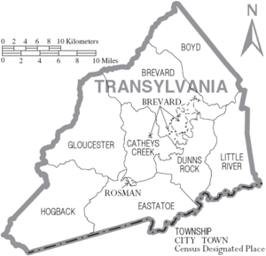
: Boyd, Brevard
, Cathey's Creek, Dunn's Rock, Eastatoe, Gloucester, Hogback, and Little River.
National protected area
of 2000 (2010 demographics not yet available), there were 29,334 people, 12,320 households, and 8,660 families residing in the county. The population density
was 78 people per square mile (30/km²). There were 15,553 housing units at an average density of 41 per square mile (16/km²). The racial makeup of the county was 93.67% White
, 4.21% Black
or African American
, 0.28% Native American
, 0.38% Asian
, 0.02% Pacific Islander
, 0.31% from other races
, and 1.12% from two or more races. 1.02% of the population were Hispanic
or Latino
of any race.
There were 12,320 households out of which 25.10% had children under the age of 18 living with them, 58.60% were married couples
living together, 8.70% had a female householder with no husband present, and 29.70% were non-families. 26.10% of all households were made up of individuals and 12.40% had someone living alone who was 65 years of age or older. The average household size was 2.30 and the average family size was 2.74.
In the county the population was spread out with 20.40% under the age of 18, 8.20% from 18 to 24, 23.10% from 25 to 44, 26.90% from 45 to 64, and 21.40% who were 65 years of age or older. The median age was 44 years. For every 100 females there were 92.70 males. For every 100 females age 18 and over, there were 89.50 males.
The median income for a household in the county was $38,587, and the median income for a family was $45,579. Males had a median income of $31,743 versus $21,191 for females. The per capita income
for the county was $20,767. About 6.60% of families and 9.50% of the population were below the poverty line, including 11.80% of those under age 18 and 7.00% of those age 65 or over.
U.S. state
A U.S. state is any one of the 50 federated states of the United States of America that share sovereignty with the federal government. Because of this shared sovereignty, an American is a citizen both of the federal entity and of his or her state of domicile. Four states use the official title of...
of North Carolina
North Carolina
North Carolina is a state located in the southeastern United States. The state borders South Carolina and Georgia to the south, Tennessee to the west and Virginia to the north. North Carolina contains 100 counties. Its capital is Raleigh, and its largest city is Charlotte...
. As of 2010, the population was 33,090. Its county seat
County seat
A county seat is an administrative center, or seat of government, for a county or civil parish. The term is primarily used in the United States....
is Brevard
Brevard, North Carolina
Brevard is a town in Transylvania County, North Carolina, United States. The 2005 population estimate by the United States Census Bureau was 6,643. It is the county seat of Transylvania County....
.
History
The county was formed in 1861 from parts of Henderson CountyHenderson County, North Carolina
Henderson County is a county located in the U.S. state of North Carolina. It is part of the Asheville, North Carolina, Metropolitan Statistical Area. As of 2008, the population was 102,367. Its county seat is Hendersonville.- History :...
and Jackson County
Jackson County, North Carolina
Jackson County is a county located in the southwest of the U.S. state of North Carolina. As of 2010, the population was 40,271. Since 1913 its county seat has been Sylva, replacing Webster.-History:...
. Its name is derived from the Transylvania Company
Transylvania (colony)
Transylvania, or the Transylvania Colony, was a short-lived, extra-legal colony founded in 1775 by Richard Henderson, who controlled the North Carolina based Transylvania Company, which had reached an agreement to purchase the land from the Cherokee in the "Treaty of Sycamore Shoals"...
and has Latin
Latin
Latin is an Italic language originally spoken in Latium and Ancient Rome. It, along with most European languages, is a descendant of the ancient Proto-Indo-European language. Although it is considered a dead language, a number of scholars and members of the Christian clergy speak it fluently, and...
origins: trans ("across") and silva or sylva ("woods").
Law and government
Transylvania County is a member of the Land-of-Sky Regional CouncilLand-of-Sky Regional Council
The Land-of-Sky Regional Council is one of the 17 regional North Carolina Councils of Governments established by the North Carolina General Assembly for the purpose of regional planning and administration. Headquartered in Asheville, North Carolina, it serves Madison, Buncombe, Henderson, and...
of governments.
Geography
According to the U.S. Census BureauUnited States Census Bureau
The United States Census Bureau is the government agency that is responsible for the United States Census. It also gathers other national demographic and economic data...
, the county has a total area of 381 square miles (986.8 km²), of which, 378 square miles (979 km²) of it is land and 2 square miles (5.2 km²) of it (0.57%) is water. Partially due to the fact that there are over 250 waterfalls in the county, Transylvania County is the wettest county in the state. This is contrasted with Buncombe County, which is thirty miles northeast of Transylvania County receiving the lowest precipitation. The Blue Ridge Parkway
Blue Ridge Parkway
The Blue Ridge Parkway is a National Parkway and All-American Road in the United States, noted for its scenic beauty. It runs for 469 miles , mostly along the famous Blue Ridge, a major mountain chain that is part of the Appalachian Mountains...
traverses through parts of the county, affording spectacular views of the Appalachian Mountains
Appalachian Mountains
The Appalachian Mountains #Whether the stressed vowel is or ,#Whether the "ch" is pronounced as a fricative or an affricate , and#Whether the final vowel is the monophthong or the diphthong .), often called the Appalachians, are a system of mountains in eastern North America. The Appalachians...
, which reach over 6000 feet (1,828.8 m) elevation in the county. The highest point, Chestnut Knob, 6025 feet (1,836.4 m), lies northwest of the county seat Brevard
Brevard, North Carolina
Brevard is a town in Transylvania County, North Carolina, United States. The 2005 population estimate by the United States Census Bureau was 6,643. It is the county seat of Transylvania County....
.
Townships
The county is divided into eight townshipsTownship (United States)
A township in the United States is a small geographic area. Townships range in size from 6 to 54 square miles , with being the norm.The term is used in three ways....
: Boyd, Brevard
Brevard, North Carolina
Brevard is a town in Transylvania County, North Carolina, United States. The 2005 population estimate by the United States Census Bureau was 6,643. It is the county seat of Transylvania County....
, Cathey's Creek, Dunn's Rock, Eastatoe, Gloucester, Hogback, and Little River.
Adjacent counties
- Henderson County, North CarolinaHenderson County, North CarolinaHenderson County is a county located in the U.S. state of North Carolina. It is part of the Asheville, North Carolina, Metropolitan Statistical Area. As of 2008, the population was 102,367. Its county seat is Hendersonville.- History :...
- east - Greenville County, South CarolinaGreenville County, South Carolina- External Links :*...
- southeast - Pickens County, South Carolina - south
- Oconee County, South Carolina - southwest
- Jackson County, North CarolinaJackson County, North CarolinaJackson County is a county located in the southwest of the U.S. state of North Carolina. As of 2010, the population was 40,271. Since 1913 its county seat has been Sylva, replacing Webster.-History:...
- west - Haywood County, North CarolinaHaywood County, North Carolina-National protected areas:* Blue Ridge Parkway * Great Smoky Mountains National Park * Pisgah National Forest -Major Highways & Roads:* Interstate 40* U.S. Highway 19* U.S. Highway 23* U.S. Highway 74* U.S...
- northwest - Buncombe County, North CarolinaBuncombe County, North Carolina-Demographics:As of the census of 2000, there were 206,330 people, 85,776 households, and 55,668 families residing in the county. The population density was 314 people per square mile . There were 93,973 housing units at an average density of 143 per square mile...
- northeast
National protected areaProtected areaProtected areas are locations which receive protection because of their recognised natural, ecological and/or cultural values. There are several kinds of protected areas, which vary by level of protection depending on the enabling laws of each country or the regulations of the international...
s
- Blue Ridge ParkwayBlue Ridge ParkwayThe Blue Ridge Parkway is a National Parkway and All-American Road in the United States, noted for its scenic beauty. It runs for 469 miles , mostly along the famous Blue Ridge, a major mountain chain that is part of the Appalachian Mountains...
(part) - Nantahala National ForestNantahala National ForestThe Nantahala National Forest, established in 1920, is a national forest located in the American state of North Carolina. The word "Nantahala" is a Cherokee word meaning "Land of the Noonday Sun." The name is appropriate as, in some spots, the sun only reaches the floors of the deep gorges of the...
(part) - Pisgah National ForestPisgah National ForestPisgah National Forest is a National Forest in the Appalachian Mountains of western North Carolina. It is administered by the United States Forest Service, part of the United States Department of Agriculture. The Pisgah National Forest is completely contained within the state of North Carolina...
(part)
Demographics
As of the censusCensus
A census is the procedure of systematically acquiring and recording information about the members of a given population. It is a regularly occurring and official count of a particular population. The term is used mostly in connection with national population and housing censuses; other common...
of 2000 (2010 demographics not yet available), there were 29,334 people, 12,320 households, and 8,660 families residing in the county. The population density
Population density
Population density is a measurement of population per unit area or unit volume. It is frequently applied to living organisms, and particularly to humans...
was 78 people per square mile (30/km²). There were 15,553 housing units at an average density of 41 per square mile (16/km²). The racial makeup of the county was 93.67% White
Race (United States Census)
Race and ethnicity in the United States Census, as defined by the Federal Office of Management and Budget and the United States Census Bureau, are self-identification data items in which residents choose the race or races with which they most closely identify, and indicate whether or not they are...
, 4.21% Black
Race (United States Census)
Race and ethnicity in the United States Census, as defined by the Federal Office of Management and Budget and the United States Census Bureau, are self-identification data items in which residents choose the race or races with which they most closely identify, and indicate whether or not they are...
or African American
Race (United States Census)
Race and ethnicity in the United States Census, as defined by the Federal Office of Management and Budget and the United States Census Bureau, are self-identification data items in which residents choose the race or races with which they most closely identify, and indicate whether or not they are...
, 0.28% Native American
Race (United States Census)
Race and ethnicity in the United States Census, as defined by the Federal Office of Management and Budget and the United States Census Bureau, are self-identification data items in which residents choose the race or races with which they most closely identify, and indicate whether or not they are...
, 0.38% Asian
Race (United States Census)
Race and ethnicity in the United States Census, as defined by the Federal Office of Management and Budget and the United States Census Bureau, are self-identification data items in which residents choose the race or races with which they most closely identify, and indicate whether or not they are...
, 0.02% Pacific Islander
Race (United States Census)
Race and ethnicity in the United States Census, as defined by the Federal Office of Management and Budget and the United States Census Bureau, are self-identification data items in which residents choose the race or races with which they most closely identify, and indicate whether or not they are...
, 0.31% from other races
Race (United States Census)
Race and ethnicity in the United States Census, as defined by the Federal Office of Management and Budget and the United States Census Bureau, are self-identification data items in which residents choose the race or races with which they most closely identify, and indicate whether or not they are...
, and 1.12% from two or more races. 1.02% of the population were Hispanic
Race (United States Census)
Race and ethnicity in the United States Census, as defined by the Federal Office of Management and Budget and the United States Census Bureau, are self-identification data items in which residents choose the race or races with which they most closely identify, and indicate whether or not they are...
or Latino
Race (United States Census)
Race and ethnicity in the United States Census, as defined by the Federal Office of Management and Budget and the United States Census Bureau, are self-identification data items in which residents choose the race or races with which they most closely identify, and indicate whether or not they are...
of any race.
There were 12,320 households out of which 25.10% had children under the age of 18 living with them, 58.60% were married couples
Marriage
Marriage is a social union or legal contract between people that creates kinship. It is an institution in which interpersonal relationships, usually intimate and sexual, are acknowledged in a variety of ways, depending on the culture or subculture in which it is found...
living together, 8.70% had a female householder with no husband present, and 29.70% were non-families. 26.10% of all households were made up of individuals and 12.40% had someone living alone who was 65 years of age or older. The average household size was 2.30 and the average family size was 2.74.
In the county the population was spread out with 20.40% under the age of 18, 8.20% from 18 to 24, 23.10% from 25 to 44, 26.90% from 45 to 64, and 21.40% who were 65 years of age or older. The median age was 44 years. For every 100 females there were 92.70 males. For every 100 females age 18 and over, there were 89.50 males.
The median income for a household in the county was $38,587, and the median income for a family was $45,579. Males had a median income of $31,743 versus $21,191 for females. The per capita income
Per capita income
Per capita income or income per person is a measure of mean income within an economic aggregate, such as a country or city. It is calculated by taking a measure of all sources of income in the aggregate and dividing it by the total population...
for the county was $20,767. About 6.60% of families and 9.50% of the population were below the poverty line, including 11.80% of those under age 18 and 7.00% of those age 65 or over.
Cities and towns
- BrevardBrevard, North CarolinaBrevard is a town in Transylvania County, North Carolina, United States. The 2005 population estimate by the United States Census Bureau was 6,643. It is the county seat of Transylvania County....
- RosmanRosman, North CarolinaRosman is a town in Transylvania County, North Carolina, United States. The population was 490 at the 2000 census. The northern terminus of U.S. Route 178 is less than one mile northwest of Rosman on U.S...
Communities
- Balsam Grove
- Cathey's Creek
- Cedar Mountain
- Connestee Falls
- Dunn's Rock
- East Fork
- Eastatoe
- Gloucester
- Lake Toxaway
- Little River
- Penrose
- Pisgah Forest
- Quebec
- Sapphire
- Silversteen
- Whitewater
- Williamson Creek
Points of interest
- Brevard Music CenterBrevard Music CenterThe Brevard Music Center is a summer institute and festival located in Brevard, North Carolina. It enrolls about four hundred students, age fourteen and older, who participate in orchestra and other large ensembles, an opera program, play chamber music, study composition, and take private lessons....
- Brevard CollegeBrevard CollegeBrevard College is a small, private, United Methodist, liberal arts college in Brevard, North Carolina. The college currently grants the Bachelor of Arts, Bachelor of Science, or Bachelor of Music degree...
- Blue Ridge ParkwayBlue Ridge ParkwayThe Blue Ridge Parkway is a National Parkway and All-American Road in the United States, noted for its scenic beauty. It runs for 469 miles , mostly along the famous Blue Ridge, a major mountain chain that is part of the Appalachian Mountains...
- DuPont State ForestDuPont State ForestDuPont State Forest is a 10,000 acre tract, located in Henderson and Transylvania counties of North Carolina. The name originates from the fact that the DuPont company arranged the sale of the original tract to the state. Portions of the forest formerly contained a manufacturing facility for the...
- Gorges State ParkGorges State ParkGorges State Park is a North Carolina state park in Transylvania County, North Carolina in the United States. The land, along Jocassee Gorges, was purchased by the state from Duke Energy Corporation in 1999. It is North Carolina's westernmost state park and one of the state's newest. The park is...
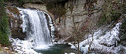
- Looking Glass FallsLooking Glass FallsLooking Glass Falls is a waterfall in Western North Carolina, located near Brevard.-Natural history:The name comes from Looking Glass Rock, which resembles a wintertime mirror of sunlight, as water freezes on its sides and reflects the sun.-Geology:The waterway is Looking Glass Creek, which flows...
- Pisgah National ForestPisgah National ForestPisgah National Forest is a National Forest in the Appalachian Mountains of western North Carolina. It is administered by the United States Forest Service, part of the United States Department of Agriculture. The Pisgah National Forest is completely contained within the state of North Carolina...
- The Wilds Christian CampThe Wilds Christian AssociationThe Wilds Christian Association, Inc. is a Protestant Christian organization that operates The Wilds Christian Camp/Conference Center in Brevard, North Carolina and The Wilds of New England in Deering, New Hampshire. Its corporate office is in Taylors, South Carolina, a suburb of Greenville...
- Waterfalls of North CarolinaWaterfalls of North CarolinaThe waterfalls of North Carolina, U.S.A., are a prominent feature of the geography of the Piedmont and mountain regions of the state, as well as a major focus of tourism and outdoor recreation. Many of these falls are located in state parks, national forests, wildlife management areas, and other...